DocumentsStaff ReportJun 15, 2026Pages 206–213
Staff Report: Development Variance Permit Application - 698, 678, 674 Atkins Ave, and 2792, 2788 Winster Rd
Report regarding a Development Variance Permit application affecting multiple properties on Atkins Avenue and Winster Road, recommending notification that Council will consider issuing the permit.
Key facts
- Addresses involved: 698, 678, 674 Atkins Ave and 2792, 2788 Winster Rd
- Agenda item 9.4; report pages 206–213
- Purpose: provide notice that Council will consider issuing the Development Variance Permit
- Follows standard public notice and consideration processes
Staff Report: Development Variance Permit Application - 698, 678, 674 Atkins Ave, and 2792, 2788 Winster Rd
Date
Monday, June 15, 2026
Department
Planning
Application No.
DVP25-0006
Subject
Application for a Development Variance Permit to allow a variety of variances at 698, 678, 674 Atkins Ave, and 2792, 2788 Winster Rd.
Executive Summary
Stantec Architecture Ltd. has applied on behalf of the City of Colwood, the Town of View Royal, and the City of Langford, for a Development Variance Permit to facilitate the expansion of the Westshore RCMP detachment at 698, 678, 674 Atkins Ave, and 2792, 2788 Winster Rd. The variances encompass a variety of setback, landscaping, and off-street parking requirements of Zoning Bylaw No. 300, which have been proposed to optimize the overall usage of the site and allow for the construction of a new building in approximately the same footprint as an existing, older portion of the detachment to be demolished.
The proposed variances should have minimal to no impact on surrounding neighbours. The setback variances have been reviewed to ensure sight lines for vehicles entering and exiting the property are maintained. The setback variance along Highway No. 14 / Veterans Memorial Parkway has been approved by the Ministry of Transportation and Transit.
Background
Previous Applications
- DP85-0004 to expand the RCMP building at 698 Atkins Ave
- Z95-0003 to rezone 682/686 Atkins Rd from the R1 to P2 zone (698 Atkins Ave) for potential RCMP expansion
- DP95-0013 to expand parking and onsite landscaping at 682/686 Atkins Rd (698 Atkins Ave)
- DVP22-0014 to increase the allowable fence height abutting a highway from 1.2 m (3.9 ft) to 3.5 m (11.5 ft) at 2788 and 2792 Winster Rd
Table 1: Site Data
| Item | Details |
|---|---|
| Applicant | Stantec Architecture Ltd. |
| Owner | City of Colwood, Town of View Royal, and City of Langford |
| Civic Address | 698 Atkins Ave, 678 Atkins Ave, 674 Atkins Ave, 2792 Winster Rd, and 2788 Winster Rd |
| Legal Description | Lot A, Section 72, Esquimalt District, Plan VIP72543, PID No. 025-105-671; Lot 12, Section 72, Esquimalt District, Plan 1954, PID No. 006-737-501; Lot 2, Section 72, Esquimalt District, Plan 34830, PID No. 000-306-118; Lot 1, Section 72, Esquimalt District, Plan 34830, PID No. 000-306-100; Lot 15, Section 72, Esquimalt District, Plan 1954, PID No. 004-188-969 |
| Size of Property | 8,534 m² (combined total) |
| DP Areas | None |
| Zoning Designation | P2, R2 |
| OCP Designation | Corridor |
Site and Surrounding Area
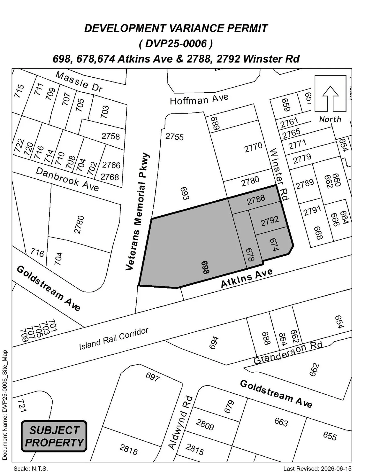
The subject properties that make up the Westshore RCMP detachment include 698, 678, and 674 Atkins Ave, as well as 2792, and 2788 Winster Road. The overall site fronts Atkins Ave and extends between Veterans Memorial Parkway and Winster Road. It contains two main buildings, of which the older (1960s) portion is to be demolished, and the remaining (1990s) portion renovated to facilitate the expansion of the Westshore RCMP detachment. The remainder of the site is used for parking fleet vehicles, and any other storage that may be required.
The subject site is located just outside the City Centre and is surrounded by a variety of land uses. To the north and west, a range of service commercial, retail, and business uses occur along with a new multi-family residential building, while the neighborhood to the east consists of a mix of single-family and duplex residential lots. The E&N trail, directly south of the site, provides connectivity to other parts of Langford and the region.
Table 2: Surrounding Land Uses
| Direction | Zoning | Use |
|---|---|---|
| North | C8 (Community Town Centre Pedestrian) | Multi-tenant commercial building |
| East | R2 (One- and Two-Family Residential) | Single-family; Duplexes |
| South | C8A (Community Town Centre Pedestrian A); C3 (District Commercial); CC1 (City Centre) | Commercial; Mixed-use |
| West | C3 (District Commercial) | Commercial; Service |
Commentary
Development Proposal
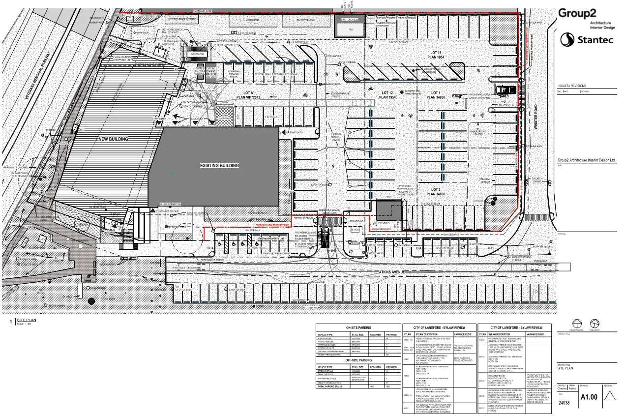
In order to expand the existing Westshore RCMP facility to meet the needs of the detachment over the next 20 years, plans have been developed to demolish the older 1960s portion of the building and replace it with a larger, four-storey structure in a similar footprint. The newer 1990s portion is to remain and will be operational throughout construction.
The subject site is currently split zoned Community Institutional (P2) and One- and Two-Family Residential (R2). While facilities for police services are permitted in any zone, numerous variances have been requested. As these properties will be consolidated into one legal parcel, the proposed expansion has been assessed in relation to the ultimate lot boundaries and their respective definitions under Zoning Bylaw No. 300.
While a number of different site layouts and designs were considered, the final design proposed as part of this application was determined to best optimize the functionality of the site and minimize impacts to the surrounding neighbourhood. Locating the new building along Highway No. 14 / Veterans Memorial Parkway was also a key design objective, to ensure the detachment maintains a strong street presence at this prominent intersection next to downtown Langford. As such, the project team discussed the proposed variances with staff and subsequently submitted this application for further consideration by Council.
In order to facilitate the proposed design, reductions to the exterior side and rear lot line setbacks have been requested. Additionally, there are reductions proposed to exterior and interior side lot line setbacks for a proposed accessory building and an existing structure. Since the exterior and rear lot line setbacks abut a Highway, encroachment into these areas should have minimal to no impact on surrounding neighbours, and the proposed setbacks have been reviewed to ensure sight lines for vehicles entering and exiting the property are maintained. Further, since the proposed setback to Highway No. 14 / Veterans Memorial Parkway (which is a Controlled Access Highway under the Transportation Act) is less than 4.5m, the Ministry of Transportation and Transit has also reviewed and approved the proposed building location and setback variance. The existing driveway exit onto Veteran Memorial Parkway will be maintained.
The applicant is also requesting the removal of certain landscaping and screening requirements to accommodate additional on-site parking. Specifically, the proposal includes eliminating the minimum width requirement for landscape and screening between parking areas abutting highways and other land uses as well as eliminating the requirement to plant low-hardy shrub with a minimum height of 1.2m at time of planting in these landscaped areas for the purpose of screening vehicle headlights. The proposed variances are intended to increase the amount of available parking on-site. There is already a substantial fence in place along the eastern and southern property boundaries, providing some visual separation and screening between the parking areas and adjoining roads.
This application was submitted prior to the adoption of Bylaw No. 2272 on May 19, 2026, which replaced Part 4 – Parking Regulations of Zoning Bylaw No. 300 with updated vehicle and bicycle parking standards. To acknowledge the design and analysis work completed to date, Council may wish to consider this application as “in-stream” and therefore subject to the previous parking regulations. As such, this application requests reducing the amount of off-street parking from the required 185 stalls to 101 stalls. Parking required by the previous Bylaw for police services was per employee, however, parking demand for the site is expected to be lower as the bylaw assumes full capacity at all times. Furthermore, the availability of parking within the Atkins Road right of way and E&N Rail Corridor is expected to mitigate the overall onsite parking demand by providing an additional 61 off-site stalls.
Alternative transportation options exist nearby, including but not limited to, the #95 RapidBus which is roughly a 5-minute walking distance from the subject site. Other options include nearby carshare opportunities, and the proximity of the adjacent E&N trail/Galloping Goose trail that provides connectivity to surrounding communities within the Capital Regional District.
A Development Permit for the form and character of the proposed building is not required due to the institutional use of the building.
Road dedication will be required in order to ensure works such as existing sidewalks are located within dedicated road rights of way rather than remaining on private property. This will occur prior to issuance of a Building Permit, and the five subject properties will be consolidated by the same subdivision plan.
Overall, the proposed variances have been summarized in Table 3 below in relation to the Zoning requirements.
Table 3: Proposal Data
| Required by Zoning Bylaw No. 300 | Proposed Variance |
|---|---|
| Exterior side lot line setback 7.5 m (24.6 ft) |
2.9 m (9.6 ft) |
| Rear lot line setback 10 m (32.8 ft) |
1.1 m (3.7 ft) |
| Accessory building setbacks: Exterior side lot line: 6 m (19.7 ft) Interior side lot line: 1 m (3.3 ft) |
Exterior side lot line: 2 m (6.6 ft) Interior side lot line: 0.5 m (1.65 ft) |
| Landscaping and screening: 1 m (3.3 ft) landscaping strip At least 3 m (9.8 ft) between parking abutting a highway or any other uses Hedge height of 1.2 m (3.9 ft) to screen vehicle headlights |
0 m |
| Off-street parking | 186 → 101 |
Financial Implications
Should the variance requests not be approved, there would be financial implications to RCMP detachment expansion project, and therefore to the City and local governments partners that own and are funding the project.
Legal Implications
Council has the authority to issue a development variance permit pursuant to the Community Charter and the Local Government Act.
Options
Option 1
THAT Council direct staff to provide notice that Council will consider issuing a Development Variance Permit for the properties 698, 678, 674 Atkins Ave, and 2792, 2788 Winster Rd:
With the following variances to setback and landscaping requirements: a. That Section 6.81.05(1) of Zoning Bylaw No. 300 be varied to reduce the exterior side lot line setback from 7.5 m to 2.9 m; b. That Section 6.81.05(3) of Zoning Bylaw No. 300 be varied to reduce the rear lot line setback from 10 m to 1.1 m; c. That Section 3.05.02(5) Zoning Bylaw No. 300 be varied to reduce the exterior side lot line setback for accessory buildings and structures from 6 m to 2 m; d. That Section 3.05.02(5) Zoning Bylaw No. 300 be varied to reduce the side lot line setback for accessory buildings and structures from 1 m to 0.5 m; e. That Section 3.21.01(1) of Zoning Bylaw No. 300 be varied to eliminate the requirement for a 1 m width landscaping and screening area; f. That Section 6.81.06 of Zoning Bylaw No. 300 be varied to eliminate the requirement for a 3 m landscape screening area; g. That Section 3.21.02(3) of Zoning Bylaw No. 300 be varied to eliminate the requirement for a shrub or hedge at a minimum height of 1.2 m between vehicle parking areas and highways; AND
Part 4 of the Zoning Bylaw No. 300 at the date of Development Variance Permit application submission shall be applicable to the development subject to the following variance: a. That Section 4.01.01 (Table 1) of Zoning Bylaw No. 300 be varied to reduce the amount of off-street parking to 101 stalls.
OR Option 2
THAT Council take no action with respect to this application for a Development Variance Permit at 698, 678, 674 Atkins Ave, and 2792, 2788 Winster Rd until the items are addressed and reviewed by Council: a. ______________; b. ______________; c. ____________.
Submitted By
Kelsey Hutt, Planning Technician
Concurrence
- Leah Stohmann, RPP, MCIP, Director of Community Planning and Development
- Melisa Miles, Manager of Legislative Services
- Donna Petrie, Senior Manager of Communications & Economic Development
- Yari Nielsen, Director of Parks, Recreation and Facilities
- Katelyn Balzer, P.Eng., Director of Engineering and Public Works
- Michael Dillabaugh, CPA, CA, Director of Finance
- Marie Watmough, Director of Legislative & Protective Services
- Braden Hutchins, Deputy Chief Administrative Officer
- Darren Kiedyk, Chief Administrative Officer
Appendix A – Proposed Site Map

Appendix B – Location Map
Document Images
(1)