DocumentsStaff ReportAug 21, 2023Pages 192–226
3405 Happy Valley Rd Rezoning Application
Staff report and attachments for the rezoning application for 3405 Happy Valley Road included under Committee Resolutions.
Key facts
- Civic address: 3405 Happy Valley Rd
- Included as Committee Resolutions item 8.5 (pages 192–226)
- Likely includes applicant details, site plans and recommended conditions
3405 Happy Valley Rd Rezoning Application
Staff Report to Sustainable Development Advisory Committee
DATE: Monday, August 14, 2023
DEPARTMENT: Planning
APPLICATION NO.: Z23-0001
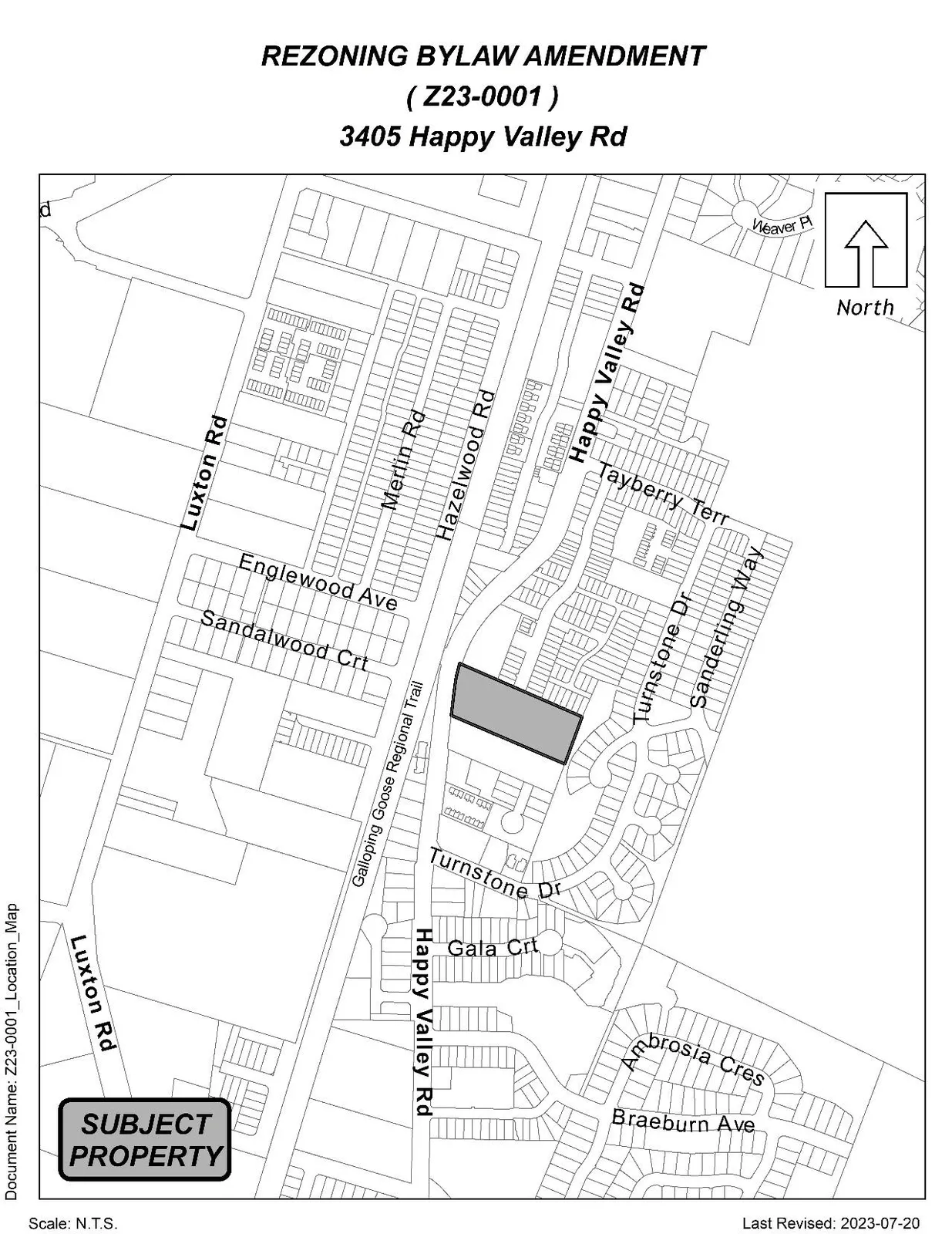
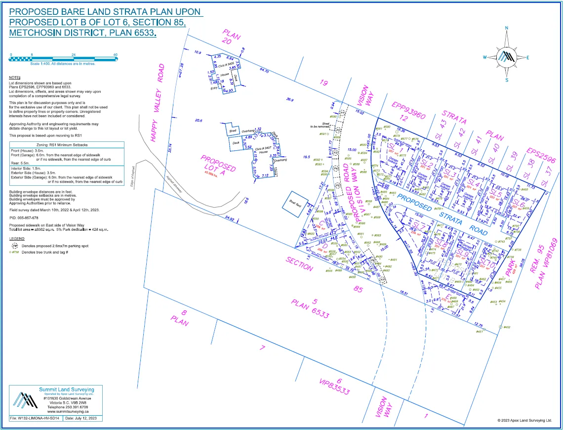
SUBJECT: Application to Rezone 3405 Happy Valley Road from Rural Residential 2 to Residential Small Lot 1 (RS1) to allow for 13 single-family lots.
PURPOSE
Mark Johnston of M.H. Johnston & Associates Inc. has applied on behalf of Patrick Stephenson to rezone 3405 Happy Valley Road from Rural Residential 2 (RR2) to Residential Small Lot 1 (RS1) to allow for development of 13 single-family lots.
BACKGROUND
Previous Applications
- DP13-0003: A development permit was issued for development within the Potential Wildlife Habitat and Biodiversity development permit area to allow for the filling in of a ravine on the property.
Table 1: Site Data
| Item | Details |
|---|---|
| Applicant | Mark Johnston, M.H. Johnston & Associates Inc. |
| Owner | Patrick Stephenson |
| Civic Address | 3405 Happy Valley Road |
| Legal Description | Lot 6, Section 85, Metchosin District, Plan 6533 |
| Size of Property | 2.2 acres (8742 m2) |
| DP Areas | Potential Habitat and Biodiversity |
| Zoning (Existing) | Rural Residential 2 (RR2) |
| Zoning (Proposed) | Residential Small Lot 1 (RS1) |
| OCP Designation (Existing) | Neighbourhood |
| OCP Designation (Proposed) | Neighbourhood |
SITE AND SURROUNDING AREA
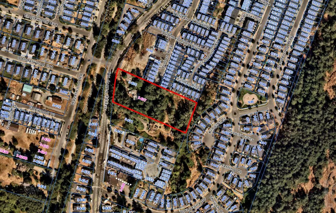
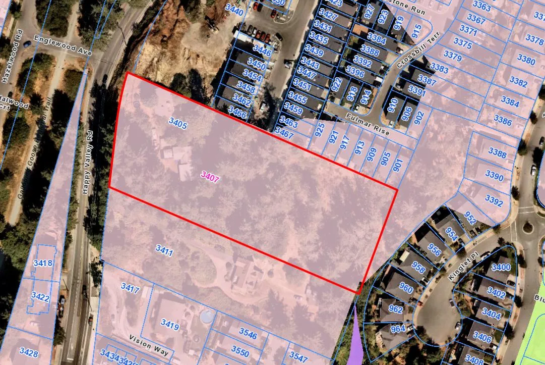
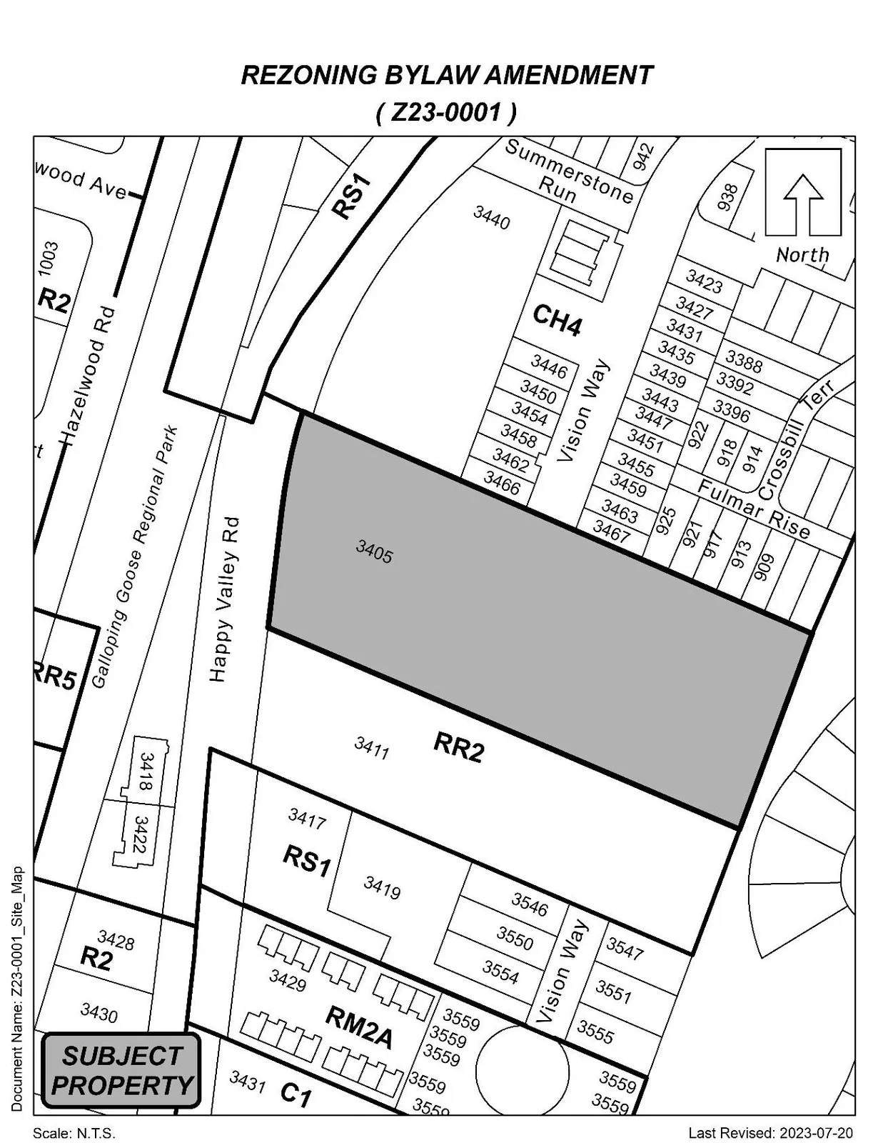
The subject property is approximately two acres in size and located to the east of Happy Valley Road. The site is predominately treed, with a detached two-family dwelling fronting Happy Valley Road. The applicant has submitted an arborist report with their application that will be discussed later in this report. The surrounding neighbourhood is made up of predominately single-family homes on lots varying in size. Vision Way will be extended through the subject property to the south property line.
Happy Valley Elementary School is located approximately 500 m away, on Happy Valley Road and Marwood Avenue. School District No 62 has been made aware of this application such that they can consider the proposed increase in density in this area as part of their long-range facility planning.
The Galloping Goose Regional Trail is located on the east side of Happy Valley Road with an access on Marwood or Englewood Avenue.

Table 2: Surrounding Land Uses
| Direction | Zoning | Use |
|---|---|---|
| North | Cluster Housing 4 (CH4) | Townhouse, Single-Family |
| East | Residential Small Lot 1 (RS1) | Single-Family Residential |
| South | Rural Residential 2 (RR2) / Residential Small Lot 1 (RS1) / Attached Housing (RM2A) | Townhouse, Single-Family |
| West | One- and Two-Family Residential (R2) | Single-Family |
COUNCIL POLICY
OFFICIAL COMMUNITY PLAN
The Official Community Plan (OCP) Bylaw No. 1200 designated the subject properties as Neighbourhood, which is defined by the following text:
- Existing settled areas throughout the community predominantly located on the valley floor.
- Predominantly residential precinct that supports a range of low and medium density housing choices including secondary suites
- This area allows for residential and mixed-use commercial intensification of streets that connect centres and/or are serviced by transit
- Schools, community facilities and other institutional uses are permitted throughout the area
- Retail serving local residents is encouraged along transportation corridors
- Home-based businesses, live-work housing is encouraged
- Parks, open spaces and recreational facilities are integrated throughout the area
- This area allows for Neighbourhood Centres to emerge in the form of medium density mixed-use nodes at key intersections.
The Neighbourhood OCP designation has an overall density objective of 16 units per acre. The proposal put forward by the applicant equates to approximately 7 units per acre, well within the objective. The Neighbourhood area also calls for small lot subdivision and clustered densification in established areas, which is achieved through this proposal.
SOUTH LANGFORD NEIGHBOURHOOD PLAN (SLNP)
The South Langford Neighbourhood Plan designates 3405 Happy Valley Road as Large Lot Residential. This designation calls for a maximum density of 4 units per acre. As noted above, the applicant’s proposal has a density of 7 units per acre which does not meet the definition of Large Lot Residential within the South Langford Neighbourhood Plan.
Council may wish to note that the South Langford Neighbourhood Plan precedes the City’s Official Community Plan. At the time, the SLNP was retained within the design guidelines as a reference. Council may wish to note that zoning is required to comply with the OCP but is not required to comply with the design guidelines (including the SLNP).
DEVELOPMENT PERMIT AREAS
The subject property is located in the Potential Habitat and Biodiversity Area and will require an Environmental Assessment completed by a registered professional biologist as part of the development permit application, should this rezoning be approved. A development permit will also be required to address the Intensive Residential design guidelines, prior to Subdivision Approval.
LOW CARBON CONCRETE
In accordance with Council’s Low Carbon Concrete Policy POL-0167-PLAN, Council may wish to require the applicant to utilize ready-mix concrete that meets or exceeds the weighted average Global Warming Potential targets based on Concrete BC Baseline (average) mix data for the construction of the proposed development.
COMMENTARY
DEVELOPMENT PROPOSAL
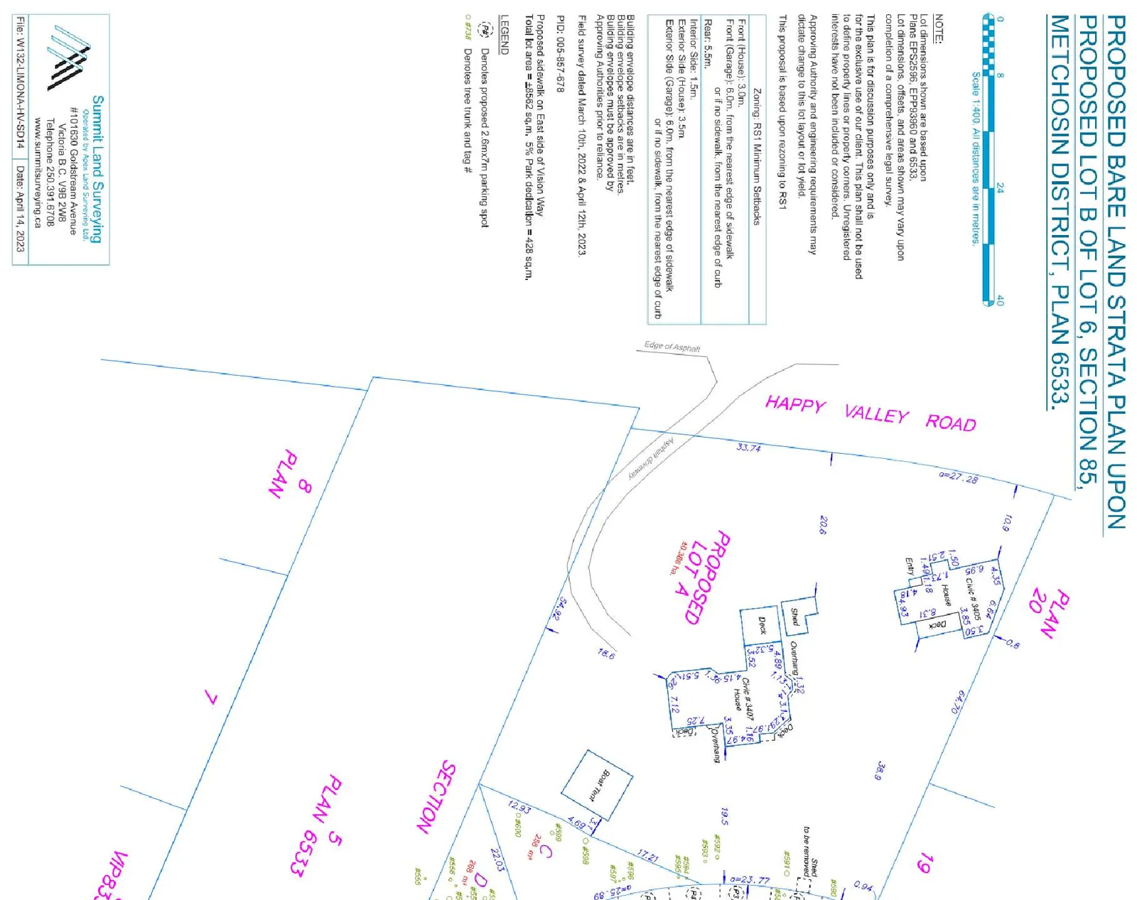
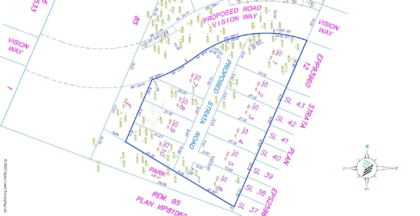
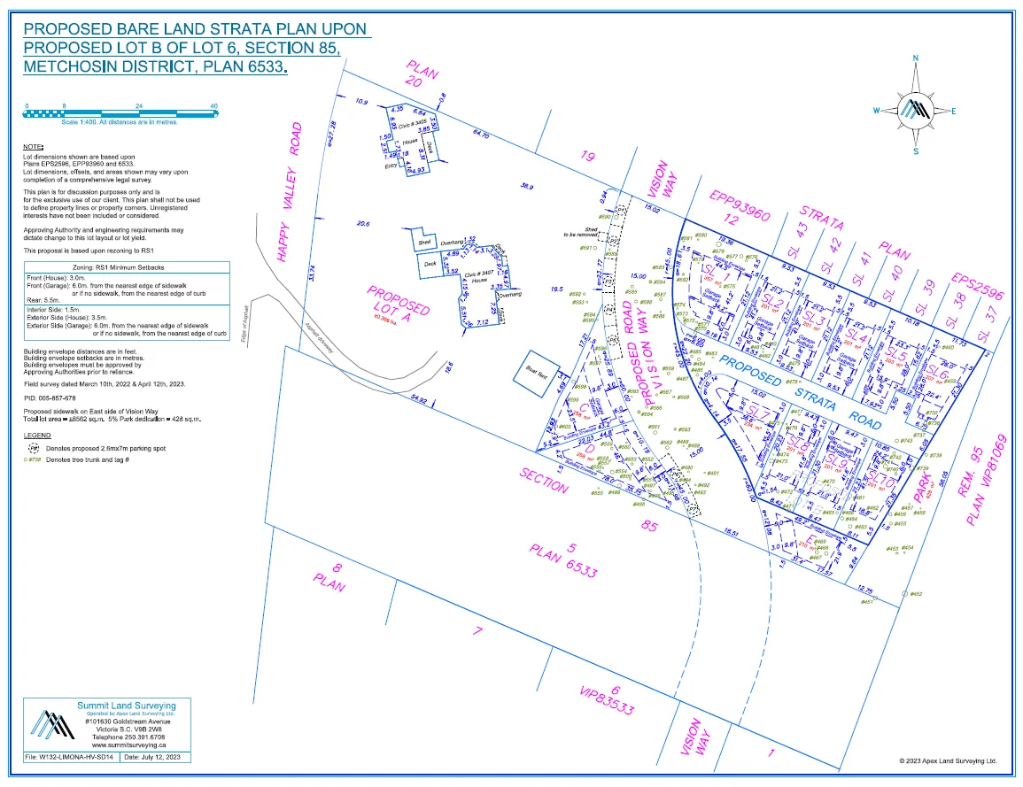
The applicant is seeking to rezone 3405 Happy Valley Road to the RS1 (Residential Small Lot 1) zone to allow for the development of 13 single-family homes and a larger ~0.37 ha lot containing the existing detached duplex. The proposed 13-lot subdivision is within the eastern portion of the subject property and will access via an extension to Vision Way. The lot containing the existing detached duplex is within the western portion of the subject property, and will continue to utilize the existing driveway from Happy Valley Rd. This larger lot is included within the proposed rezoning application, so it could be developed in a similar as the eastern portion of the property at a later date.
The single-family lot sizes proposed as part of this application are all at least 200 m2, in accordance with the RS1 zone regulations. The applicant’s current proposal demonstrates a driveway and garage which can accommodate two vehicles. These details would be confirmed in the required form and character development permit and checked again at the time of building permit. The single-family homes do not require any variances to the requirements of the zone, and each provide ample backyard space with depths of 5.5 m. Council may wish to request that the applicant register a Section 219 Covenant securing that the garages of the new-build single-family homes are not used for storage in a manner that prohibits the parking of vehicles.
Council may wish to note that secondary suites are permitted over 400m2 lots however none of the lots proposed are over the minimum lot size.
In accordance with section 510(5) of the Local Government Act, the Parks, Recreation and Facilities department prefers to receive 5% parkland dedication instead of cash-in-lieu as the proposed parkland is located adjacent to previously obtained parkland dedication. Council may wish to request that the applicant register a Section 219 covenant requiring the parkland be dedicated to the City prior to subdivision approval.
The applicant has submitted an arborist report, which is attached to this report for reference, assessing all trees on and off site that may be impacted to determine their potential for retention. The arborist assessed a total of 109 trees. Of these, 95 trees are proposed for removal due to their health and/or location with respect to the proposed development. 7 trees of these trees are located within the proposed park dedication, however all 7 have been recommended for removal for hazard mitigation purposes. The removal of the trees on this property is subject to the requirements of the Environmental Development Permit. The arborist's report lays out tree protection plan requirements, which should be implemented in accordance with the requirements of Bylaw No. 1000 prior to the commencement of work on-site in relation to any tree within the proposed park that the Director of Parks, Recreation and Facilities confirms to be retained in addition to the 7 trees identified for retention in the report. Additionally, construction fencing should be installed on the border of the proposed park and remainder of the property to mitigate construction impact to the satisfaction of the Director of Parks, Recreation and Facilities.
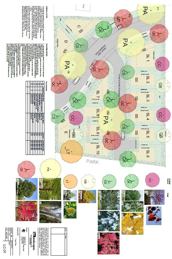
New boulevard tree plantings, replacement tree plantings and other park improvements required by Bylaw No. 1000 can be provided within the dedicated parkland as required by the Director of Parks, Recreation and Facilities as part of the subdivision process. The preliminary landscape plan is attached to this report as Appendix A, indicating the anticipated type and location of new trees.
As the proposed strata road is less than 90 meters, no two-point turnaround is required; however, the proposed extension of Vision Way exceeds 305 meters, which is the maximum distance of a public road without a second route available to emergency vehicles. Due to this, the applicant will require a variance prior to Subdivision Approval. This variance is an interim solution until the road can be extended as part of a future redevelopment of the adjacent property to the south, and connect to the other portion of Vision Way, which intersects with Happy Valley Rd. The Fire Chief has indicated that he does not object to the variance, provided that the temporary two-point turnaround can accommodate fire trucks’ movements.
Table 3: Proposal Data
| Item | Permitted by RR2 (Current Zoning) | Permitted by RS1 (Proposed Zoning) | Proposed by Rezoning Application |
|---|---|---|---|
| Permitted Use | Single-family home with suite, duplex, agriculture, golf course, equestrian facility, group daycare, cemetery, among others | Single-family home, duplex and home occupation. | Single-family homes |
| Density (FAR and/or min. lot size) | 4-hectare min. lot size | 200m2 single-family lots | 200m2 single-family lots |
| Height | 10.5 m | 9 m | 9 m |
| Site Coverage | N/A | 50% | N/A |
| Front Yard Setback | 7.5 m | 3 m or 6 m for garage | 3 m or 6 m for garage |
| Interior Side Yard Setback | 3 m | 1.5 m | 1.5 m |
| Exterior Side Yard Setback | 3 m or 5.5 m for garage | 3.5 or 6 m for garage | 3.5 or 6 m for garage |
| Rear Yard Setback | 10 m | 5.5 m | 5.5 m |
| Vehicle Parking Requirement | 2 spaces + 1 additional for a suite | 2 spaces | 2 spaces |
MULTI-MODAL NETWORK
BC Transit bus stops are located near the development site, and provide service to Routes 48, 54, 55, and 64 to the Langford Exchange and Metchosin. Most of these routes only run once per hour or two, with increased service during peak commuting hours. It’s anticipated that as the population in this neighbourhood grows, transit service will improve.
As per the site plan, driveway access to the single-family homes will occur off Vision Way. The Director of Engineering has noted that no Traffic Impact Assessment is required, and the property falls inside of the 800 m highway buffer which will require Ministry of Transportation and Infrastructure approval. The Ministry has indicated that they have no objections with regards to this application.
INFRASTRUCTURE
STORMWATER MANAGEMENT
The applicant will be required to provide a stormwater management plan to the satisfaction of the Director of Engineering prior to the issuance of a building permit or subdivision approval, whichever is first. As part of their application, the applicant has submitted a stormwater technical memo outlining how they plan to adequately manage stormwater on-site. This memo has been reviewed and approved by the Director of Engineering.
SEWER
A sewer main exists within Happy Valley and Vision Way fronting this site. The developer will be required to connect new development to the main, through approved civil drawings. Any sewer works within dedicated road right of ways will be constructed by West Shore Environmental Services at the applicant’s expense.
ROAD DEDICATION
The applicant has proposed road dedication of approximately 3 metres in width along Happy Valley Road. The exact amount of road dedication along Happy Valley Road still needs to be determined and dedicated prior to bylaw adoption, to the satisfaction of the Director of Engineering.
FRONTAGE IMPROVEMENTS
The proposed extension of Vision Way will require full frontage improvements prior to issuance of a building permit or subdivision approval, whichever is first. Additionally, Happy Valley Road at this location will require full frontage improvements however Council may wish to require the applicant to register a section 219 covenant prior to bylaw adoption that ensures the applicant constructs the frontage improvements along Happy Valley Road prior to subdivision of “Proposed Lot A”.
NEIGHBOURHOOD IMPACT
POTENTIAL NUISANCES
As has been past practice in this neighbourhood, Council may wish to require the applicant to provide a Section 219 Covenant registered on title prior to Bylaw Adoption that provides future landowners with the understanding that a variety of agricultural uses and the South Vancouver Island Rangers gun range are located within close proximity of the site, that these pre-existing uses may result in general nuisances, and that future landowners understand and accept the potential disruption to their residential occupancy of the site.
CONSTRUCTION PARKING AND TRAFFIC MANAGEMENT PLAN
Council may wish to require a Construction Parking and Traffic Management Plan as a condition of rezoning and require that it be provided to the satisfaction of the Director of Engineering prior to any land alteration. This should be secured within a covenant, prior to Bylaw Adoption.
NEIGHBOURHOOD CONSULTATION
The applicant has stated they will be sending letters to the surrounding neighbours of this development and will be completed prior to the Sustainable Development Advisory Committee meeting.
FINANCIAL IMPLICATIONS
Rezoning the subject properties to permit higher density of development will increase the assessed value of lands and eventually will increase municipal revenue due to the number of units created. As the developer is responsible to complete all frontage improvements, the direct capital costs to the City associated with this development will be negligible. A summary of Amenity Contributions and Development Cost Charges that the developer will be expected to pay, is outlined in Tables 4 and 5 below.
Table 4 – Amenity Contributions per Council Policy
| Amenity Item | Per unit contribution | Total (13 SFDs) |
|---|---|---|
| General Amenity Reserve Fund | $3,960 per single family lot under 550 m2 | $51,480 |
| Affordable Housing Reserve Fund | $660 per single family lot under 550 m2 | $8,580 |
| TOTAL POLICY CONTRIBUTIONS | $60,060 |
Table 5 - Development Cost Charges
| Development Cost Charge | Per Unit Contribution | Total (13 SFDs) |
|---|---|---|
| Roads | $3,865 per small lot (≤300 m2) | $46,380 |
| $5,876 per single-family (>300m2) | $5,876 | |
| Storm Drainage | $1,166 per small lot (≤300 m2) | $13,992 |
| $1,878 per single-family (>300m2) | $1,878 | |
| Park Improvement | $1,948 per small lot (≤300 m2) | $23,376 |
| $3,146 per single-family (>300m2) | $3,146 | |
| Park Acquisition | $130 per small lot (≤300 m2) | $1,560 |
| $211 per single-family (>300m2) | $211 | |
| ISIF | $371.25 per residential lot < 400m2 (no suite) | $4,826.25 |
| ISA | $52 | $676 |
| Subtotal (DCC’s to Langford) | $101,921.25 | |
| CRD Water | Low Density Residential ($2,922/unit) | $37,986 |
| School Site Acquisition | Low Density Residential ($1,000/unit) | $13,000 |
| TOTAL DCC’s (estimated) | $152,907.25 |
As noted, the larger lot containing the existing detached duplex, while not proposed to be subdivided at this time, will have subdivision potential under the proposed RS1 Zone. If and when this lot subdivides in the future, additional amenity contributions and DCCs will be required at that time.
LEGAL IMPLICATIONS
Should Council choose to proceed with consideration of this rezoning, a Public Hearing will be scheduled in accordance with the requirements of the Local Government Act.
The amenity contributions specified in Table 4 above are incorporated into a bylaw, and will be payable at the time of subdivision approval along with the current Development Cost Charges specified in the various DCC Bylaws.
Council’s other conditions of approval would be registered in a Section 219 Covenant in priority of all other charges on title prior to consideration of Bylaw Adoption.
OPTIONS
Option 1
THAT the Sustainable Development Advisory Committee recommend that Council:
Direct staff to prepare a bylaw to amend the zoning designation of 3405 Happy Valley Road from the Rural Residential (RR2) zone to the Residential Small Lot 1 (RS1) zone subject to the following terms and conditions:
a. That the applicant provides, as a bonus for increased density, the following contributions per lot, prior to the issuance of a building permit:
i. $660 towards the Affordable Housing Reserve Fund per lot under 550m2; and
ii. $3,960 towards the General Amenity Reserve Fund per lot under 550m2;b. That the applicant registers, prior to Bylaw Adoption, a road dedication plan, to the satisfaction of the Director of Engineering;
c. That the applicant provides, prior to Bylaw Adoption, a Section 219 covenant, registered in priority of all other charges on title, that agrees to the following:
i. That the following will be provided and implemented to Bylaw No. 1000 standards to the satisfaction of the Director of Engineering prior to the issuance of a building permit or subdivision approval, whichever is first:
- A storm water management plan; and
- A construction parking management plan.
ii. That full frontage improvements along the extension of Vision Way will be provided and implemented to Bylaw No. 1000 standards to the satisfaction of the Director of Engineering prior to the issuance of a building permit or subdivision approval, whichever is first.
iii. That full frontage improvements along Happy Valley Road will be provided and implemented to Bylaw No. 1000 standards to the satisfaction of the Director of Engineering prior to subdivision approval of “Proposed Lot A”.
iv. That a separate covenant be registered prior to issuance of a building permit for the proposed development agreeing that the garages are to be used for the parking of vehicles and not the storage of items preventing the parking of vehicles therein.
v. That, prior to commencement of work, tree protection measures inclusive of tree protection fencing are implemented to protect the trees identified for retention in the arborist report, and as confirmed by the Director of Parks, Recreation and Facilities with respect to the dedicated parkland, throughout the construction period;
vi. That, prior to commencement of work, construction fencing is installed to delineate the dedicated parkland from the remainder of the property to the satisfaction of the Director of Parks, Recreation and Facilities throughout the construction period;
vii. That 5% of the lot area be dedicated as parkland and any improvement including hazard tree mitigation, replanting, invasive removal, and other improvements are completed under the supervision of a Registered Profession Biologist and to the satisfaction of the Director of Parks, Recreation and Facilities prior to subdivision approval;
viii. That all concrete used on-site will utilize ready-mix concrete that meets or exceeds the weighted average Global Warming Potential targets based on Concrete BC Baseline (average) mix data, and that prior to the issuance of a Building Permit the applicant shall provide a Type III Environmental Product Declaration that is 3rd party verified specifying the total Global Warming Potential value;
AND
Direct staff to provide notice that Council will consider issuing a Development Variance Permit for the property at 3405 Happy Valley Road with the following variance:
a. That Section 4.17.1 of the Subdivision and Development Servicing, Bylaw No. 1000, be varied to increase the minimum length of road requiring two access routes available to emergency vehicles from 305 m to 370 m, subject to:
i. That a temporary turnaround is constructed and secured to the satisfaction of the Fire Chief, prior to subdivision approval.
OR Option 2
That the Sustainable Development Advisory Committee recommend that Council take no action with respect to this application to rezone 3405 Happy Valley Road until such time as the following items are addressed and reviewed by the Sustainable Development Advisory Committee:
- ________________;
- ________________;
- ________________.
SUBMITTED BY: Matt Notley, Planner I
Concurrences:
Leah Stohmann, MCIP, RPP, Deputy Director of Planning and Subdivision
Donna Petrie, Senior Manager of Business Development and Events
Yari Nielsen, Director of Parks, Recreation and Facilities
Matthew Baldwin, MCIP, RPP, Director of Planning and Subdivision
Katelyn Balzer, P.Eng., Director of Engineering and Public Works
Michael Dillabaugh, CPA, CA, Director of Finance
Marie Watmough, Deputy Director of Corporate Services
Braden Hutchins, Director of Corporate Services
Darren Kiedyk, Chief Administrative Officer
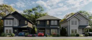
Appendix A – Landscape Plan
Appendix B – Site Plan
Appendix C – Site Map
Appendix D – Location Map
Arborist Report
Capital Tree Service Inc.
Arborist Report
3405 Happy Valley Road, Langford, BC V9C 2X9
July 21, 2023
Revised July 28, 2023
Prepared for: TEKloch Homes
Prepared by: Capital Tree Service Inc.
Cover / Contact
Capital Tree Service Inc.
310-777 Royal Oak Dr, PO Box 53512, Victoria BC, V8X 5K2
Ph: 250-217-8370, email: joelcreese@capitaltreeservice.ca
capitaltreeservice.ca
GST # 861289783RT0001
WSBC Account #713323
Liability and Professional E and O, HSM Insurance - $5 Million
Summary / Scope of Work
Capital Tree Service Inc. (CTS) was contacted by John Sercombe of TEKloch Homes (Client), a local development firm, regarding a strata development at 3405 Happy Valley Road (the Site) in the city of Langford. The Client has requested that CTS provide an Arborist Report regarding the trees on the site. A tree inventory is included as Appendix ‘A’. Photographs and a Site Plan are included as Appendix ‘B’ of this report.
Methodology
The Site was entered on March 7, 2023 by CTS for the purpose of conducting tree assessments and collecting inventory. Joel Creese and Ray Praud, a consulting arborists and representatives of CTS, provided the BVTA for the site. The weather that day was 8°C and Overcast with a 10km/h South Breeze.
The Site was assessed from grade. No form of diagnostic tools or invasive techniques were used during the assessment, including excavation or assessment of roots below. Diameters were measured using a Richter Diameter Tape. Diameter at Breast Height (DBH) was measured approximately 1.4m above grade. Measurements and observations were recorded with the intent to provide a static representation of the area. A tree inventory is included as Appendix ‘A’ of this report. Photographs and a Site Plan are included as Appendix ‘B’ of this report.
During the assessment, one hundred and nine (109) trees of concern were observed – all (109) of which are protected as they are located within a Habitat and Biodiversity Development Permit Area. Trees referenced in Appendix ‘A’ and located on the site have been tagged. Tags are located approximately 1.5-2m above grade on tree stems and were visible at the time of assessment.
Protected Root Zone
Protected Root Zone calculations are based on the ISA recommended one foot for each one inch of trunk diameter (0.3m for each 2.5 cm). Matheny and Clark’s ‘Trees and Development’ was used to assess relative tolerance to Development Impacts.
Discussion
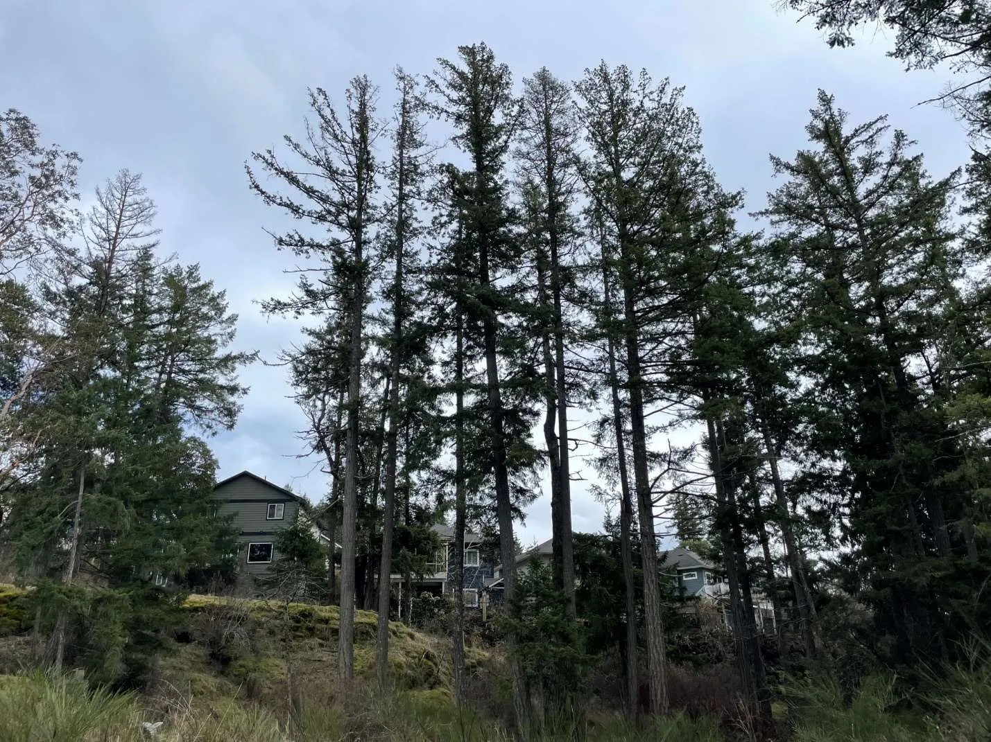
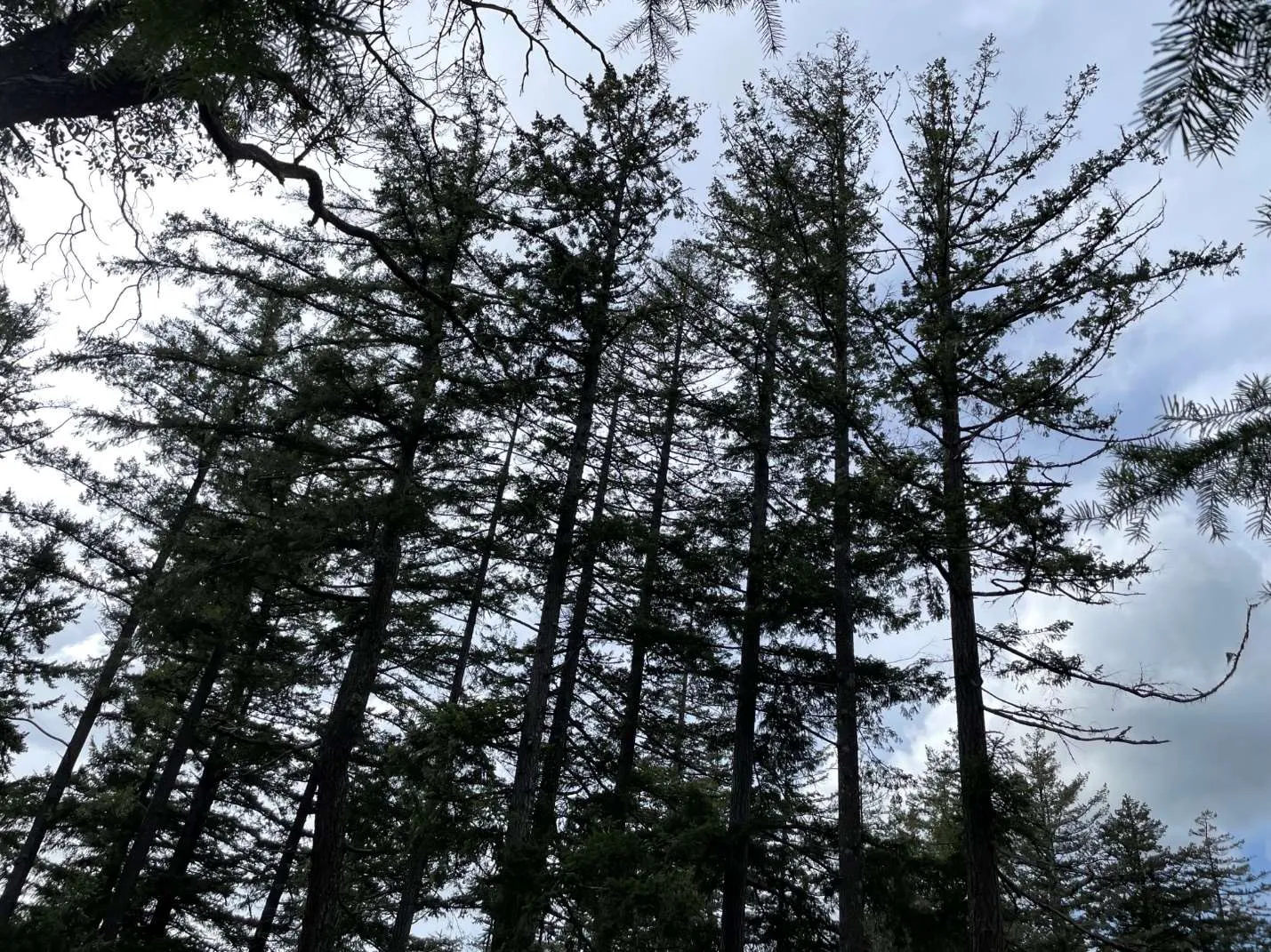
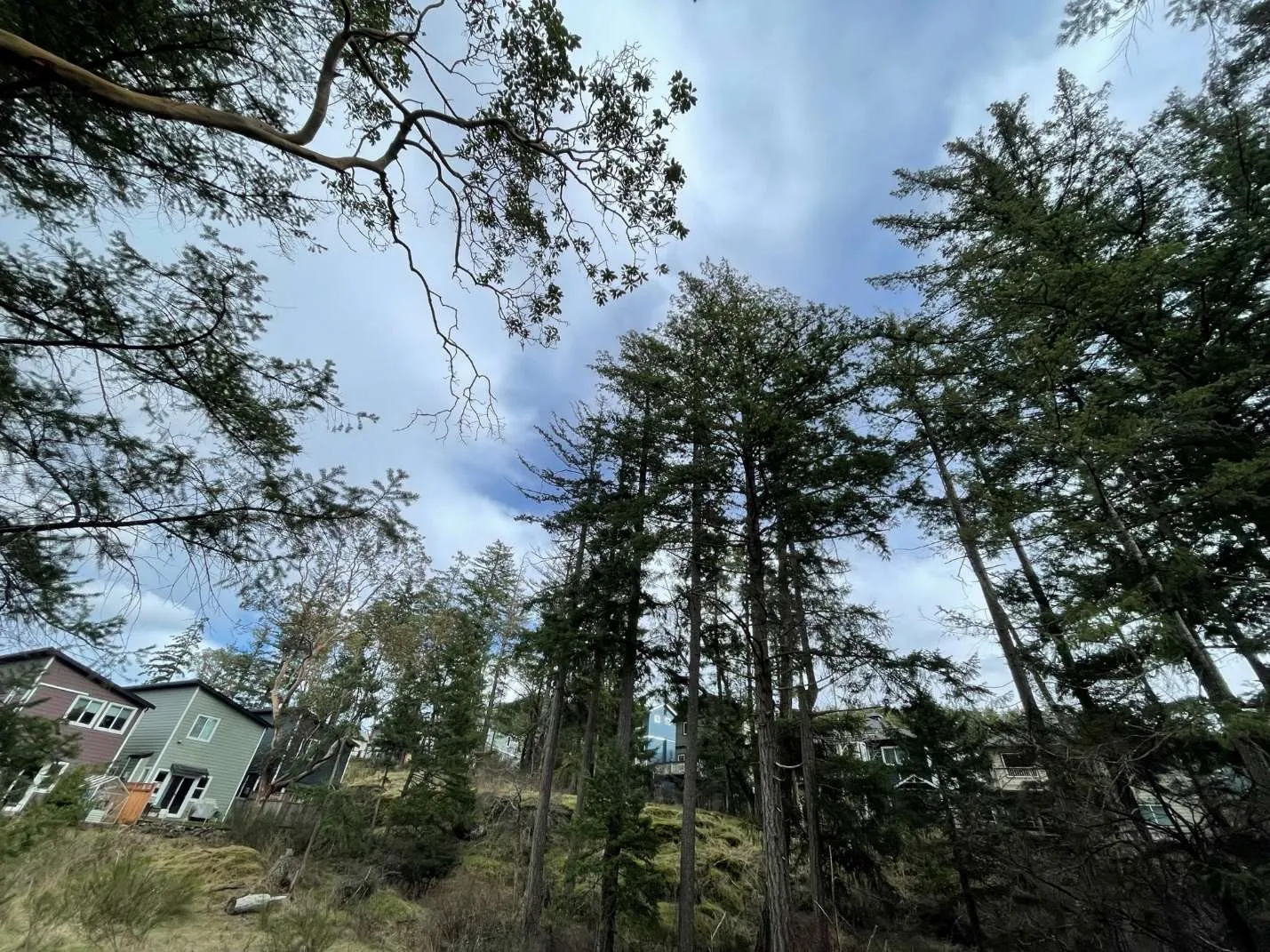
During the assessment, a partially treed rocky parcel surrounded by new construction on two sides and Happy Valley Rd on the fourth side. The site is located within a Habitat and Biodiversity Development Permit Area (DPA). The trees appear to be second and third growth forest. Tree species on site primarily consists of Douglas fir, Arbutus, Shore pine, with several other tree species intermixed. The growth and structure of the trees of concern are indicative of those that have grown in a stand with poor taper, poor live crown ratios, and stem deflections, often due to phototrophic growth in early growing years.
One hundred and nine (109) trees were inventoried due to possible impacts, all of which are protected as they are located within a Habitat and Development DPA.
Table 1. Expected Tree Impacts. All trees within the footprint of the Vision Way extension, Strata road, Strata building lots, and Lots C-D are proposed for removal.
| Location | DPA Protected | Vision Way Extension | Strata Road | Strata Building Lots | Lot C | Lot D | Lot E | Park | Retain |
|---|---|---|---|---|---|---|---|---|---|
| Count | 25 | 8 | 38 | 7 | 14 | 3 | 7 | 7 |
The trees located on the proposed park dedication (tagged 451-458 and 738) are all Douglas firs located on the eastern side of the lot. If the proposed development is approved and the houses built, the trees of concern would pose a high risk over the next two years. The trees were observed to be shallowly rooted on bedrock with limited available soil volume for anchoring. Laminated root rot, Phellinus weirii, is suspected to be present in many of these firs. The development activities that have occurred surround the site have likely changed the hydrology, a factor that will be further affected by the planned development on the site. Winds are often funneled through the Happy Valley. Once the site has been cleared for the planned development, the trees of concern will be almost fully exposed, except by southwesterly winds, thus increasing the likelihood of failure to probable. Due to the proximity of existing and proposed houses within one tree length on three sides the likelihood of impact is considered to be high. Therefore, with high value targets, the risk is considered to be high. These trees are expected to continue to decline. If the trees of concern are not removed (or the associated risks otherwise mitigated), it is possible that these trees could become an extreme risk the relatively near future (timeline based on rate of decline) with few options for safe removal. Safe removal or mitigation of these trees will be limited due a more confined space due to the proposed houses, limited accessibility due to the proposed houses and difficult terrain and decreased structural stability as the decline of the trees is expected to continue. If the proposed development is approved and this area becomes park land, wildlife trees would be a viable option rather than complete removal. If these trees were to be reduced and left standing as wildlife trees, they should be topped at a height such that there are no significant targets within one (1) tree length.
Replacement trees will be required for any tree removed or modified within the parkland. Replacement tree ratios are determined by tree size as specified in Section 14.2.6.3. of the City of Langford Subdivision and Development Servicing Bylaw (No. 1000). A total twenty-one (21) replacements trees will be required, please see Table 2 for a replacement tree breakdown.
Table 2. Replacement Trees
| Number of Removals (size category) | Replacement Trees required for each removal | Total Trees |
|---|---|---|
| 15-30cm | 1 → 2 | 2 |
| 30-45cm | 1 → 3 | 3 |
| 45-90cm | 4 → 4 | 16 |
| Total | 6 → (as above) | 21 |
Common and Latin Names
- Grand fir – Abies grandis
- Red alder – Alnus rubra
- Arbutus – Arbutus menziesii
- Shore pine – Pinus contorta var. contorta
- Cherry – Prunus subg. Prunus
- Douglas fir – Pseudotsuga menziesii
- Garry oak – Quercus garryana
- Pacific yew – Taxus brevifolia
Tree Condition Ratings Summary
Health Condition:
- Poor - significant signs of visible stress and/or decline that threaten the long-term survival of the specimen.
- Fair - signs of stress.
- Good - no visible signs of significant stress and/or only minor aesthetic issues.
Structural Condition:
- Poor - Structural defects that have been in place for a long period of time to the point that mitigation measures are limited.
- Fair - Structural concerns that are possible to mitigate through pruning.
- Good - No visible or only minor structural flaws that require no to little pruning.
Species Relative Tolerance to Construction Impacts:
- Fir – Generally Moderate-good – “Tolerant of root loss.”
- Red alder – Poor-moderate – “Retain only in groups or as individuals with strong taper and structure. Relatively short lived. Intolerant to root injury.”
- Arbutus – Poor – “Intolerant of site disturbance.”
- Pine – Generally Moderate-Good
- Cherry – Moderate – “Intolerant of mechanical injury (poor compartmentalization).”
- Douglas Fir – Poor-good – “Tolerant of fill soil if limited to one-quarter of root zone. However, may decline slowly following addition of fill. Tolerant of root pruning. Intolerant of poor drainage.”
Tree Protection Plan
- Utilize Tree Protection Fencing (TPF) to restrict access to Tree Protection Zones. Provide signage on fencing which states: Tree Protection Area – No Admittance. Signage must be in a visible location attached to the fence. Signage must be attached to the outside of each Tree Protection Fencing area.
- Contact CTS to mark locations for the Tree Protection Fencing. All Tree Protection Fencing must be installed in the locations indicated by CTS. CTS must provide inspection and verification of the fencing detail for City approval.
- Each Tree Protection Zone (TPZ) must be vacated of all construction materials and/or equipment. At no time may the fencing be removed or modified unless the Project Arborist is contacted and approval given. In such cases the Project Arborist must assist fence removal and assess combined impacts which are required for construction completion. Capital Tree Service 250-217-8370 – Three business days notice required.
Landing/Storage Area
All construction materials will be stored outside of the protected root zone of any retained tree. These locations are indicated on the Site Plan.
Access
A single point of access shall be utilized. Contractors and workers shall be made aware of the Tree Protection Zones and Measures in place. Access will be from the front of the property from Smythe St. Tree Protection Zones and areas of the Site not under construction or within the Zone of Impact will be strictly off limits. It is the responsibility of the Client to schedule a pre-job meeting with the Project Arborist to discuss Tree Protection Plans, Zones, and requirements. Five business days notice required. Project Arborist. 250-217-8370
Root Assessment and Observation
The Project Arborist must be on site for observation and assessment when working within the Protected Root Zone of any Protected Trees. This included any retained park tree and trees partially or entirely on a lot that is not proposed for development.
Tree Pruning
Tree pruning required for access and egress, tree health and safety shall be performed by an International Society of Arboriculture (ISA) Certified Arborist without the use of climbing spurs. All tree pruning shall be performed in accordance with ANSI A-300 Standards for Tree Care Operations.
Blasting
The use of blasting for removal of rock may cause serious damage or death to nearby trees if not managed appropriately. CTS recommends the use of low nitrogen and low velocity explosives. Furthermore, we recommend the use of explosives to strategically fracture the rock before using an excavator to breakup (using a hoe ram) and remove the rock. It is critical that ¾” plywood is used to protect (armour) retained trees and that heavy matting is used to dampen shockwaves. A removal plan for the rock will be developed with the blasting contractor and the Project Arborist. It is recommended that this plan is created prior to the blasting contractor providing a cost estimate.
Tree Protection Plan Summary
i. Provide a detailed sign specifying that tree protection measures are in place and will be followed during the project. Fines will be posted for malicious acts and can be placed on individuals who disregard the tree protection plan and its guidelines. Signs will be placed at each entrance of the project detailing what is expected when working in potentially high impact tree protection zones.
ii. Provide tree protection fencing for all trees identified with protection requirement in this report. This fencing shall be four (4ft) feet in height and made of orange plastic. If required, header and footer boards will be used to secure the protective fencing.
iii. Tree protection and root protection signs will be placed on the fencing. No entry will be allowed, unless specified by the Project Arborist and in their presence while on site.
iv. Restrict vehicle traffic to designated access routes and travel lanes to avoid soil compaction and vegetation disturbances.
v. Make all necessary precautions to prevent the storage of material, equipment, stockpiling of aggregate or excavated soils within tree protection areas. No dumping of fuels, oils or washing of concrete fluids will be allowed in tree protection zones.
vi. Provide an onsite arborist when a risk of root damage, root cutting, or limb removal is required within the tree protection zone.
vii. Avoid alterations to existing hydrological patterns to minimize vegetation impacts to the site.
viii. The use of a Project Arborist is required to provide layout of tree protection zones. The Project Arborist(s) will provide pre-construction information to all parties involved with the project. The Project Arborist must be notified 72hrs prior to construction activities in sensitive areas. The Project Arborist should be used to provide root and branch pruning when diameters are greater than 6cm.
ix. At no time will tree protection zones be removed from the project unless approved by the Project Arborist.
Excavation Process Plan
- Provide and schedule Project Arborist to assess site prior to construction.
- Inventory and identify trees and hazards which could complicate excavation process.
- Utilize hand tools and cutting equipment when large tree roots are anticipated.
- When possible, utilize small, rubberized track excavation equipment which will reduce soil compaction.
- Excavator operator must be well informed about dig site and goal to complete project.
- Use shallow excavation sweeps across the site to establish a depth which roots can be easily identified. (3cm to 5cm in depth of soil for each sweep across the soil face)
- Roots greater than 6cm in diameter shall be preserved and inspected by the Project Arborist. The project arborist will determine if roots should be pruned or cut.
- All roots greater than 6cm in diameter should be identified and documented for project records.
- Photos are highly recommended for documentation purposes.
Assessment of the site may expose further tree issues or conditions. If this occurs the project arborist will contact City Staff for further recommendations.
Role of the Project Arborist
As well as creating the Tree Preservation Plan, the Project Arborist must be on site to supervise work within or immediately adjacent to the tree protection areas identified on the attached tree plan. This will include sidewalk, driveway and any improvements proposed for the municipal boulevard. The Project Arborist will be present to supervise landscaping operations and activity within the tree protection areas.
At completion of the project, the Project Arborist will confirm that any tree protection or remediation related deficiencies have been addressed by the owner and building contractor. Once all deficiencies (if any) have been remedied, the Project Arborist shall prepare a letter to the City of Langford confirming completion of the project.
The following is a summary of key roles of the Project Arborist:
- Participation in a site meeting prior to the commencement of works adjacent to Tree Protection Zones to discuss the preservation plan and tree protection measures in place. It is the responsibility of the Client to schedule a pre-work site meeting. Five days Notice Required. CTS 250-217-8370
- The meeting will review the Tree Protection Plan, Tree Protection Zones and the specific measures required to protect the trees during the site preparation, construction and landscape phases of construction.
- The Project Arborist will inspect the Tree Protection Fencing and any other tree protection measures prior to a tree permit being issued by the City and prior to work commencing on site.
- The Project Arborist will be on site during the following work within or immediately adjacent to the Tree Protection Areas as indicated on the attached Site Plan:
- demolition
- grading
- excavation
- rock removal or blasting
- trenching for underground services and utilities
- preparation of grade for the proposed driveways and parking areas
- site inspections to insure adherence to Tree Protection Measures
Although this site has been assessed trees in the landscape are dynamic and changes could occur. This report is a static representation of the site during our assessment.
Keegan Durovich 07/28/2023
Capital Tree Service Inc.
ISA Certified Arborist TRAQ PN-9272A
B.A.Sc.
CONDITIONS OF ASSESSMENT AGREEMENT
This Conditions of Assessment Agreement is made pursuant to and as a provision of CTS, providing tree assessment services as agreed to between the parties, the terms and substance of which are incorporated in and made a part of this Agreement (collectively the “Services”).
(Full Conditions of Assessment Agreement text provided in report.)
Acknowledged by:
Name of Customer: John Sercombe of TEKloch Homes, 3405 Happy Valley Road, Langford, BC V9C 2X9
Authorized Signature: _______________________________________________
Date: 2023-07-28
Appendix ‘A’ – Tree Inventory
- Conditions: 8°C, Overcast, 10km/h South light breeze.
- Table 1. Tree Inventory for 3405 Happy Valley Rd. Diameter at breast height (DBH) is measured in centimeters. Protected root zones (PRZ) are calculated using a 0.12 multiplier and represent the protected radius area around the tree in meters. Site notes included: Trees are rooted on bedrock. Limited soil. Phellinus weirii likely present in whole area. Changes to hydrology due to surrounding development. Site will be fully exposed when cleared. Previously sheltered area- all new exposure to the East and North. West to be exposed.
| Tag # | Species | DBH (cm) | PRZ (m) | Health / Structure | Protected | Action | Comments |
|---|---|---|---|---|---|---|---|
| 451 | Douglas Fir | 86 | 10 | F-P/F | Yes | Retain | Over extended branches. Epicormics. Uneven canopy. Deadwood. Shared ownership. |
| 452 | Douglas Fir | 90 | 11 | F/F | Yes | Retain | 10+cm hanger. Over extended branches. Rooted on bedrock. Shared ownership. |
| 453 | Douglas Fir | 52 | 6 | P/P | Yes | Park Habitat Tree | Previously topped. Stem deflections. Dieback. 10cm Deadwood. |
| 454 | Douglas Fir | 36 | 4 | Dead | Yes | Park Habitat Tree | Dead. |
| 455 | Douglas Fir | 61 | 7 | F-P/G-F | Yes | Park Habitat Tree | Epicormics. Dieback. Deadwood. Over extended branches. Uneven canopy. |
| 456 | Douglas Fir | 67 | 8 | F-P/F | Yes | Park Habitat Tree | Epicormics. Dieback. 10cm Deadwood. Over extended branches. Uneven canopy. Lean. |
| 457 | Douglas Fir | 19 | 2 | F-P/F | No | Park Habitat Tree | Dieback. Deadwood. Suppressed. Understory. Over extended branches. Possible fungal infection. |
| 458 | Douglas Fir | 24 | 3 | F-P/P | Yes | Park Habitat Tree | Dieback. Deadwood. Suppressed. Understory. Over extended branches. Possible fungal infection. Topped. |
| 459 | Douglas Fir | 29 | 3 | F/F-P | Yes | Strata Lot Removal | Over extended branches. Stem deflections. Uneven canopy. Resinosis. |
| 460 | Arbutus | 51 | 6 | P/F | Yes | Strata Lot Removal | Dieback. 10cm Deadwood. Little foliar area. Development within CRZ. |
| 461 | Pacific yew | 24 | 3 | F-P/P | Yes | Strata Lot Removal | Basal damage. Dieback. Deadwood. Epicormics. Rooted on rock. Topped. |
| 462 | Red alder | 33 | 4 | P/F-P | Yes | Strata Lot Removal | Lean. Stem dieback. Epicormics. |
| 463 | Douglas Fir | 75 | 9 | F/F | Yes | Strata Lot Removal | Dieback. 10cm Deadwood. Uneven canopy. Hangers. Over extended branches. |
| 464 | Douglas Fir | 67 | 8 | F-P/F | Yes | Strata Lot Removal | Stem deflections. Epicormics. 10cm deadwood. Resinosis. Over extended branches. |
| 465 | Douglas Fir | 48 | 6 | F/P | Yes | Strata Lot Removal | Dieback. 5cm Deadwood. Epicormics. Over extended branches. Topped. |
| 466 | Douglas Fir | 27 | 3 | F-P/F-P | Yes | Strata Lot Removal | Suppressed. Understory. Galls on branches. Over extended branches. |
| 467 | Douglas Fir | 75 | 9 | F/F-P | Yes | Lot E Removal | Resinosis. Swollen basal stem. Epicormics. Over extended branches. Uneven canopy. |
| 468 | Douglas Fir | 60 | 7 | F/F | Yes | Lot E Removal | Stem deflections. Epicormics. Dieback. Deadwood. |
| 469 | Douglas Fir | 20 | 2 | F/P | Yes | Lot E Removal | Suppressed. Dieback. Deadwood. Stem deflections. Topped. Over extended branches. |
(Inventory continues — entries below excerpted from the report:)
| 470 | Douglas Fir | 26 | 3 | F-P/P | Yes | Strata Lot Removal | Dieback. Deadwood. Uneven canopy. Epicormics. Rooted on rock. Basal cavity. | | 471 | Douglas Fir | 69 | 8 | P/P | Yes | Strata Lot Removal | Stem dieback. Dead top. 10cm deadwood. | | 472 | Douglas Fir | 59 | 7 | P/F | Yes | Strata Lot Removal | Significant dieback. 10cm deadwood. Over extended branches. | | 473 | Douglas Fir | 89 | 11 | F-P/F | Yes | Strata Lot Removal | Significant dieback. 10cm deadwood. Over extended branches. Stem deflections. Epicormics. | | 474 | Arbutus | 27 | 3 | F/P | Yes | Strata Lot Removal | Basal cavity. Dieback. | | 475 | Arbutus | 22 | 3 | F-P/F | Yes | Strata Lot Removal | Dieback. Little foliar area. Mutated root crown. Suspected internal decay. | | 476 | Arbutus | 28 | 3 | F-P/F-P | Yes | Strata Lot Removal | Dieback. Little foliar area. Mutated root crown. Suspected internal decay. | | 477 | Douglas Fir | 36 | 4 | P/F-P | Yes | Strata Lot Removal | High cone production. Dieback. Deadwood. Uneven canopy. Epicormics. Slight lean. | | 478 | Douglas Fir | 40 | 5 | F-P/F-P | Yes | Strata Road Removal | High cone production. Dieback. Deadwood. Uneven canopy. Epicormics. Slight lean. | | 479 | Douglas Fir | 27 | 3 | F/F-P | Yes | Strata Lot Removal | Lean. Dieback. Deadwood. Rooted next to dead stump. | | 480 | Arbutus | 31 | 4 | G-F/G | Yes | Strata Lot Removal | Hanger. Mutated root crown. Epicormics. | | 481 | Arbutus | 24 | 3 | P/P | Yes | Strata Lot Removal | Stem dieback. Serious decline. Cavities in basal stem. Uneven canopy. | | 482 | Arbutus | 26 | 3 | P/P | Yes | Strata Lot Removal | Stem dieback. Serious decline. Cavities in basal stem. Uneven canopy. | | 483 | Douglas Fir | 42 | 5 | F-P/P | Yes | Strata Road Removal | Dieback. 10cm Deadwood. Lean, previously partial root failure. High cone productions. | | 484 | Douglas Fir | 62 | 7 | F-P/F | Yes | Strata Road Removal | Rope girdled. Stem deflections. Dieback. 10cm Deadwood. Resinosis. Reaction wood on south side of trunk. | | 485 | Douglas Fir | 46 | 6 | F-P/P | Yes | Strata Road Removal | Over extended branches. Lean. Dieback. Deadwood. | | 486 | Douglas Fir | 54 | 6 | F-P/P | Yes | Strata Road Removal | Uneven canopy. Dieback. Deadwood. Epicormics. Stem dieback. Rope girdled. | | 487 | Douglas Fir | 50 | 6 | F-P/F-P | Yes | Vision Way Removal | Uneven canopy. Dieback. Deadwood. Epicormics. Stem dieback. | | 488 | Douglas Fir | 25 | 3 | F/F | Yes | Vision Way Removal | Lean swollen basal stem. Dieback. Deadwood. Epicormics. | | 489 | Douglas Fir | 21 | 3 | F-P/F-P | Yes | Vision Way Removal | Lean swollen basal stem. Dieback. Deadwood. Epicormics. | | 490 | Douglas Fir | 38 | 5 | F/F | Yes | Vision Way Removal | Lean swollen basal stem. Dieback. Deadwood. | | 491 | Douglas Fir | 33 | 4 | P/F-P | Yes | Vision Way Removal | Lean swollen basal stem. Dieback. Deadwood. | | 492 | Shore pine | 34 | 4 | F-P/P | Yes | Vision Way Removal | Lean. Codominant top. Previously topped. Suppressed. Understory. Deadwood. | | 493 | Douglas Fir | 37 | 4 | F-P/P | Yes | Vision Way Removal | Lean. Codominant top. Previously topped. Suppressed. Understory. Deadwood. | | 494 | Douglas Fir | 28 | 3 | P/P | Yes | Vision Way Removal | Little live foliar area. Dieback. Deadwood. Topped. Lean. | | 495 | Douglas Fir | 24 | 3 | F/P | Yes | Lot D Removal | Lean. Codominant top. Previously topped. Suppressed. Understory. Deadwood. | | 496 | Douglas Fir | 44 | 5 | F-P/P | Yes | Lot D Removal | Grafted to 497 at grade. Stem deflections. Poor live crown ratio. Epicormics. Dieback. 5cm Deadwood. | | 497 | Douglas Fir | 41 | 5 | F-P/P | Yes | Lot D Removal | Grafted to 496 at grade. Stem deflections. Poor live crown ratio. Epicormics. Dieback. 5cm Deadwood. | | 498 | Douglas Fir | 57 | 7 | F-P/F-P | Yes | Retain | Dieback. 10cm Deadwood. Epicormics. Over extended branches. Lean. Shared ownership. | | 499 | Douglas Fir | 76 | 9 | F-P/P | Yes | Lot D Removal | Lean. Stem deflections. Over extended branches. Dieback. Deadwood. |
(Additional inventory entries continue in the full report; excerpt continues:)
| 500 | Douglas Fir | 33 | 4 | F/P | Yes | Lot D Removal | Topped. Poor live crown ratio. Suppressed. Understory. | | 551 | Douglas Fir | 31 | 4 | F-P/P | Yes | Lot D Removal | Lean. Uneven canopy. Over extended branches. Dieback. 5cm Deadwood. Topped. | | 552 | Douglas Fir | 33 | 4 | F-P/P | Yes | Lot D Removal | Stem deflections. Poor live crown ratio. Dieback. Deadwood. Uneven canopy. | | 553 | Douglas Fir | 54 | 6 | F-P/P | Yes | Lot D Removal | Stem deflections. Poor live crown ratio. Dieback. Deadwood. | | 554 | Douglas Fir | 74 | 9 | F-P/P | Yes | Lot D Removal | Sweeping stem at grade. Epicormics. Dieback. 10cm Deadwood. Poor live crown ratio. | | 555 | Shore pine | 29 | 3 | F/F-P | Yes | Retain (Private Tree) | Uneven canopy. Topped. Sap deposit on wound 1.5m above grade. | | 556 | Douglas Fir | 51 | 6 | F-P/P | Yes | Lot D Removal | Codominant stems 1.8m above grade. Resinosis. Poor aspect ratio. Narrow angle of attachment and included bark in union. Dieback. Deadwood. Seam in below union. | | 557 | Douglas Fir | 29 | 3 | F/P | Yes | Lot D Removal | Lean. Stem deflections. Resinosis. High cone production. | | 558 | Douglas Fir | 23 | 3 | F/F | Yes | Lot D Removal | Lean. Possible fungal infection. Swollen basal stem. Dense foliage. Understory. | | 559 | Douglas Fir | 53 | 6 | F-P/F-P | Yes | Lot D Removal | Poor live crown ratio. Stem deflections. Over extended branches. Ivy. Above grade structural roots. | | 560 | Douglas Fir | 26 | 3 | F-P/F-P | Yes | Lot D Removal | Suppressed. Resinosis. Basal damage. Stem deflections. Dieback. Deadwood. | | 561 | Douglas Fir | 67 | 8 | F-P/P | Yes | Vision Way Removal | Stem deflections. Dieback. 10cm Deadwood. Poor live crown ratio. Basal cavity. | | 562 | Douglas Fir | 68 | 8 | F-P/P | Yes | Vision Way Removal | Sweeping stem at grade. Dieback. 10cm Deadwood. Over extended branches. | | 563 | Arbutus | 50 | 6 | F/F-P | Yes | Vision Way Removal | Uneven canopy. Minor dieback. Phototrophic growth. | | 564 | Douglas Fir | 58 | 7 | P/P | Yes | Vision Way Removal | Lean. Dieback and deadwood. Sparse canopy. Stem deflections. | | 565 | Douglas Fir | 33 | 4 | F-P/P | Yes | Vision Way Removal | Severe lean. Dieback. Deadwood. Topped. | | 566 | Douglas Fir | 48 | 6 | Dead | Yes | Vision Way Removal | Dead. | | 567 | Douglas Fir | 45 | 5 | F-P/P | Yes | Vision Way Removal | Sweeping stem at grade. Dieback. Deadwood. Resinosis. | | 568 | Douglas Fir | 45 | 5 | F-P/F-P | Yes | Vision Way Removal | Poor live crown ratio. Over extended branches. Sparse canopy. | | 569 | Shore pine | 57 | 7 | F-P/P | Yes | Vision Way Removal | Sparse canopy. Stem deflections. Dieback. Deadwood. | | 570 | Douglas Fir | 60 | 7 | F-P/F | Yes | Strata Road Removal | Dieback. Deadwood. Over extended branches. Epicormics. Slight lean. | | 571 | Douglas Fir | 39 | 5 | F/F | Yes | Strata Lot Removal | Minor deadwood. High cone production. Dense foliage. Poor taper. | | 572 | Douglas Fir | 28 | 3 | F-P/F | Yes | Strata Lot Removal | Suppressed. Understory. Dieback. Wound 5m above grade. | | 573 | Douglas Fir | 40 | 5 | P/F-P | Yes | Strata Lot Removal | Dieback. Deadwood. High cone production. Sparse canopy. Sweeping stem. | | 574 | Douglas Fir | 27 | 3 | P/P | Yes | Strata Lot Removal | Dieback. Deadwood. Codominant top. Previously topped. | | 575 | Douglas Fir | 42 | 5 | F-P/P | Yes | Strata Lot Removal | Stem deflections. Dieback. Deadwood. | | 576 | Douglas Fir | 41 | 5 | F/F-P | Yes | Strata Lot Removal | Gravel up to root crown. Development in CRZ. Dieback. Epicormics. Lean. | | 577 | Douglas Fir | 64 | 8 | F/F-P | Yes | Strata Lot Removal | Resinosis. Roots likely cut during development in CRZ. Large hanger. Epicormics. Over extended limbs. Deadwood. | | 578 | Douglas Fir | 100 | 12 | F/P | Yes | Strata Lot Removal | Dieback. Deadwood. Over extended branches. Large roots cut during development in CRZ. | | 579 | Shore pine | 25 | 3 | F-P/P | Yes | Strata Lot Removal | Poor live crown ratio. Understory tree. Little foliar area. Torsion crack. | | 580 | Douglas Fir | 25 | 3 | P/F-P | Yes | Strata Lot Removal | Sweeping stem at grade. Over extended branches. Epicormics. Understory tree. Mechanical damage to basal stem. | | 581 | Douglas Fir | 25 | 3 | F-P/P | Yes | Strata Lot Removal | Sweeping stem at grade. Over extended branches. Epicormics. Understory tree. | | 582 | Grand fir | 51 | 6 | F-P/F-P | Yes | Strata Lot Removal | Dieback. Low vigour. Sweeping stem. Uneven canopy. | | 583 | Douglas Fir | 63 | 8 | F-P/F-P | Yes | Vision Way Removal | Stem deflections. Overextended branches. Dieback. Deadwood. Resinosis. | | 584 | Douglas Fir | 54 | 6 | F-P/F-P | Yes | Vision Way Removal | Stem deflections. Overextended branches. Dieback. Deadwood. | | 585 | Douglas Fir | 60 | 7 | F-P/P | Yes | Vision Way Removal | Overextended limbs. Dieback. 10cm Deadwood. Topped. | | 586 | Douglas Fir | 56 | 7 | P/F-P | Yes | Vision Way Removal | Dieback. Dieback. 10cm Deadwood. Little foliar area. Poor live crown ratio. | | 587 | Douglas Fir | 58 | 7 | F-P/F-P | Yes | Vision Way Removal | Poor live crown ratio. Over extended branches. Dieback. | | 588 | Douglas Fir | 26 | 3 | F/P | Yes | Vision Way Removal | Understory tree. Uneven canopy. Stem deflections. Topped. | | 589 | Douglas Fir | 35 | 4 | F/P | Yes | Vision Way Removal | Sweeping stem at grade. Previous partial uproot. Dieback. Deadwood. | | 590 | Arbutus | 67 | 8 | F/F-P | Yes | Vision Way Removal | Sweeping stem at grade. Deadwood. | | 591 | Douglas Fir | 62 | 7 | F/F-P | Yes | Retain (Private Tree) | Over extended branches. Deadwood. Uneven canopy. | | 592 | Douglas Fir | 50 | 6 | F/F | Yes | Retain (Private Tree) | Uneven canopy. Dieback. Deadwood. | | 593 | Douglas Fir | 36 | 4 | F-P/P | Yes | Retain (Private Tree) | Lean. Dieback. Deadwood. Suppressed. | | 594 | Cherry | 22 | 3 | F-P/P | Yes | Lot C Removal | Lean. Basal decay with ramshorns. Dieback. Deadwood. | | 595 | Cherry | 22 | 3 | F-P/P | Yes | Lot C Removal | Basal decay with ramshorns. Dieback. Deadwood. Stem deflections. | | 596 | Douglas Fir | 33 | 4 | F-P/P | Yes | Lot C Removal | Sweeping stem. Dieback. Deadwood. Resinosis. Epicormics. | | 597 | Douglas Fir | 25 | 3 | F-P/F-P | Yes | Lot C Removal | Lean. Dieback. Deadwood. Epicormics. | | 598 | Douglas Fir | 76 | 9 | F-P/F-P | Yes | Lot C Removal | Epicormics. Resinosis. Over extended branches. Deadwood. | | 599 | Douglas Fir | 53 | 6 | F/P | Yes | Lot C Removal | Sweeping stem. Rooted adjacent to cut and compartmentalized stump. Uneven canopy. | | 600 | Douglas Fir | 54 | 6 | F/F-P | Yes | Lot C Removal | Poor live crown ratio. Epicormics. Over extended branches. Ramshorns on basal stem. | | 735 | Garry Oak | 14 | 2 | P/P | No | Strata Lot Removal | Understory tree. Pest damage to stem. | | 736 | Douglas Fir | 69 | 8 | P/P | Yes | Strata Lot Removal | Severe dieback. Extensive dead wood. Sloughing bark. Unsuitable to retain. | | 737 | Douglas Fir | 57 | 7 | P/P | Yes | Strata Road Removal | Resinosis. Poor taper. Branch dieback. In decline. Unsuitable to retain. | | 738 | Douglas Fir | 53 | 6 | P/P | Yes | Park Habitat Tree | Branch dieback. In decline. Phellinus werii present. Unsuitable to retain. | | 739 | Douglas Fir | 97 | 12 | P/P | Yes | Strata Lot Removal | Pest infestation. Sloughing bark. Stem deflection. Dead wood. In decline. Exposed roots-possible shift. | | 740 | Douglas Fir | 49 | 6 | P/P | Yes | Strata Lot Removal | Stem damage. Stressed. Sub-average elongation of new growth. Unsuitable to retain. | | 741 | Douglas Fir | 86 | 10 | P/P | Yes | Strata Lot Removal | Unbalanced canopy. Significant branch dieback. In decline. Unsuitable to retain. | | 742 | Douglas Fir | 56 | 7 | P/P | Yes | Strata Lot Removal | Poor stem taper. Significant branch dieback. In decline. Epicormic. Unsuitable to retain. | | 743 | Douglas Fir | 72 | 9 | P/P | Yes | Strata Road Removal | In decline. Branch dieback. Epicormic. Unsuitable to retain. |
(End of excerpted inventory in report pages provided)
Appendix ‘B’ – Photos and Site Plan