DocumentsAppendixApr 17, 2023Pages 35–61
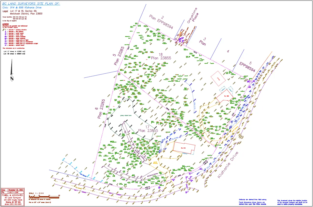
Arborist Attachments (Tree Inventory spreadsheet, site survey, preliminary grading plans) - scanned
Scanned supporting materials for the arborist report including detailed tree inventory spreadsheet, site survey and preliminary grading plans.
Key facts
- Contains the detailed tree inventory and critical root zone calculations
- Preliminary grading and site survey included as supporting visuals
- Pages scanned / image-dominant (OCR quality low)
898 and 914 Klahanie Drive - Tree Resource Spreadsheet (Preliminary Only)
Inventory date(s)
- August 8, 9, and 11, 2022
- January 16/17, 2023
Prepared by
Tamaki Urban Forestry Consultants Ltd.
Box 48153, RPO Uptown
Victoria, BC V8Z 7H6
Ph: (250) 479-8733 — Fax: (250) 479-7050
Email: timtreeshelp@gmail.com
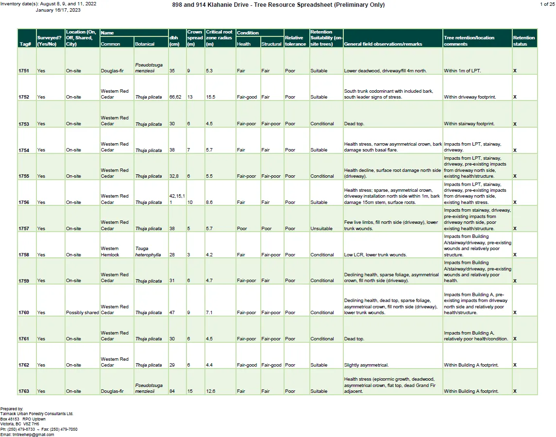
Table of Contents / Document Overview
Note: The following pages (1–25 of the Tree Resource Spreadsheet) consist primarily of tabular tree inventory data for the subject properties at 898 and 914 Klahanie Drive. The tables include columns such as Tag#, Surveyed? (Yes/No), Location (On, Off, Shared, City), Common Name, Botanical Name, dbh (cm), Crown spread (cm), Critical root zone radius (m), Condition (Health), Structural, Relative tolerance, Retention Suitability (on-site trees), General field observations/remarks, Tree retention/location comments, and Retention status. Where images of the spreadsheet pages appear in the original PDF they are noted below.
Tree Inventory Tables (Pages 1–25 of the Tree Resource Spreadsheet)
Note: The full inventory is presented as a multi-page spreadsheet table. Each spreadsheet page contains many rows of tree records with the columns listed below. The images show the detailed entries. Below are the table column headings and representative structure. (The full tabular content is presented in the images; each image is noted.)
Table columns (as presented in the spreadsheet)
- Tag#
- Surveyed? (Yes/No)
- Location (On, Off, Shared, City)
- Name — Common
- Name — Botanical
- dbh (cm)
- Crown spread (cm)
- Critical root zone radius (m)
- Condition — Health
- Condition — Structural
- Relative tolerance
- Retention Suitability (on-site trees)
- General field observations/remarks
- Tree retention/location comments
- Retention status
Representative Extracted Entries (first rows as visible on Page 1 of the spreadsheet image)
Note: The original spreadsheet contains many rows. The following rows are transcribed as representative examples from the first visible page of the table. All dollar amounts, dates, addresses, and bylaw numbers that appear in the images are preserved where visible.
| Tag# | Surveyed? | Location | Common Name | Botanical Name | dbh (cm) | Crown spread (cm) | Critical root zone radius (m) | Condition — Health | Condition — Structural | Relative tolerance | Retention Suitability | General field observations/remarks | Tree retention/location comments | Retention status |
|---|---|---|---|---|---|---|---|---|---|---|---|---|---|---|
| 1751 | Yes | On-site | Douglas-fir | Pseudotsuga menziesii | 35 | 6 | 5.3 | Fair | Fair | Poor | Suitable | Lower deadwood, driveway/fill 4m north. | Within 1m of LPT. | X |
| 1752 | Yes | On-site | Western Red Cedar | Thuja plicata | 88,82 | 13 | 15.5 | Fair-good | Fair | Poor | Suitable | South trunk codominant with included bark, south leader signs of stress. | Within driveway footprint. | X |
| 1753 | Yes | On-site | Western Red Cedar | Thuja plicata | 30 | 6 | 4.5 | Fair-poor | Fair-poor | Poor | Conditional | Dead top. | Within stairway footprint. | X |
| 1754 | Yes | On-site | Western Red Cedar | Thuja plicata | 38 | 7 | 5.7 | Fair | Fair | Poor | Suitable | Health stress, narrow asymmetrical crown, bark damage south basal flare. | Impacts from LPT, stairway, driveway. | X |
| 1755 | Yes | On-site | Western Red Cedar | Thuja plicata | 32,8 | 6 | 5.5 | Fair-poor | Fair-poor | Poor | Conditional | Health decline, surface root damage north side (driveway). | Impacts from LPT, stairway, driveway; pre-existing impacts from driveway north side; existing health/structure. | X |
| 1756 | Yes | On-site | Western Red Cedar | Thuja plicata | 42,15,1 | 10 | 8.6 | Fair | Fair | Poor | Suitable | Health stress; sparse, asymmetrical crown, driveway installation north side within 1m, bark damage 15cm stem, surface roots. | Impacts from LPT/stairway/drivway, pre-existing impacts from driveway, nearby north side impacts; health stress. | X |
| 1757 | Yes | On-site | Western Red Cedar | Thuja plicata | 38 | 6 | 5.7 | Poor | Poor | Poor | Unsuitable | Few live limbs, fill north side (driveway), lower trunk wounds. | Impacts from Building A, walkway, driveway; pre-existing wounds; relatively poor health. | X |
Additional Spreadsheet Pages (2–25) — images and descriptions
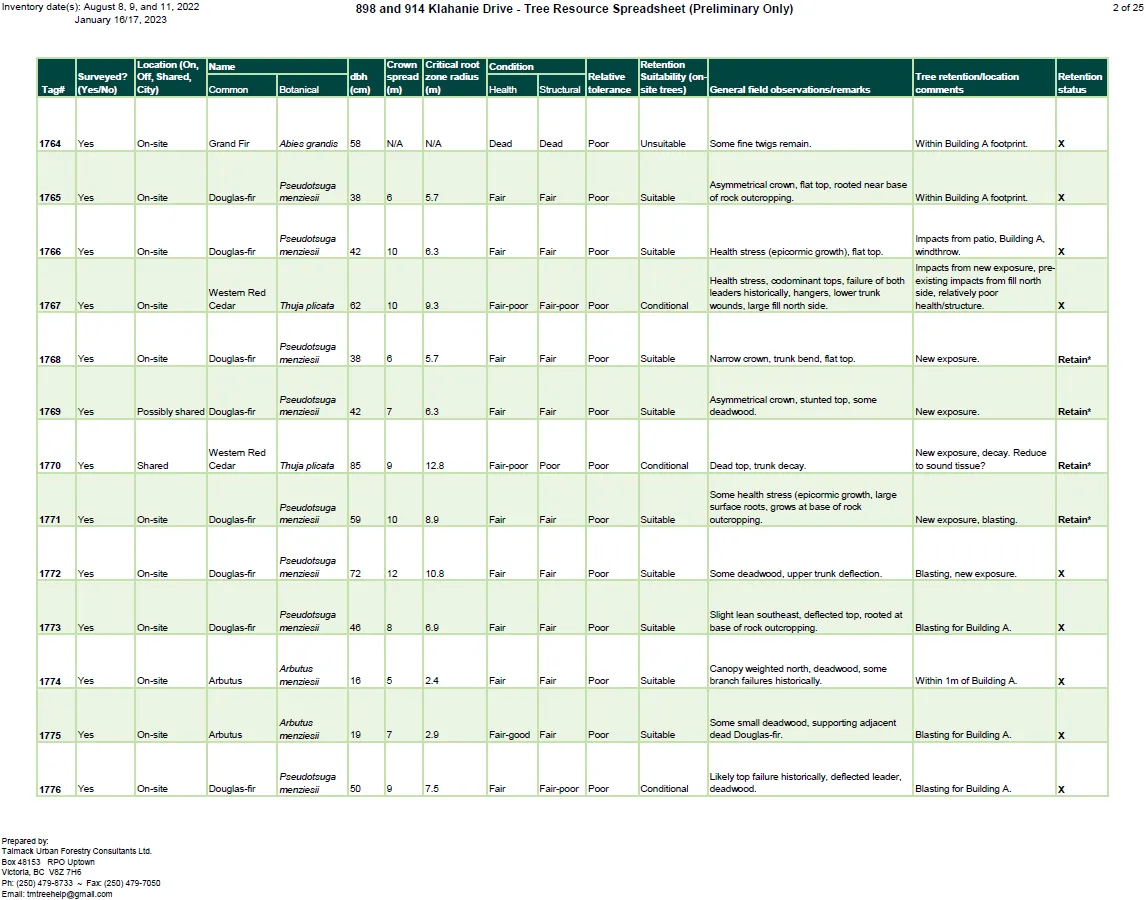
- Page 2 of the Tree Resource Spreadsheet (Tag numbers approx. 1764–1776):
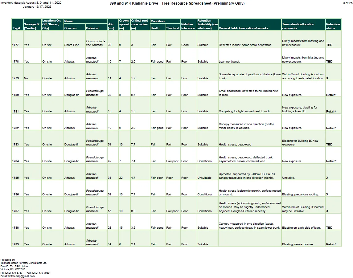
spreadsheet page - Page 3 (Tag numbers approx. 1777–1789):
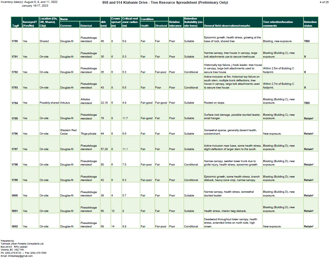
spreadsheet page - Page 4 (Tag numbers approx. 1790–1802):
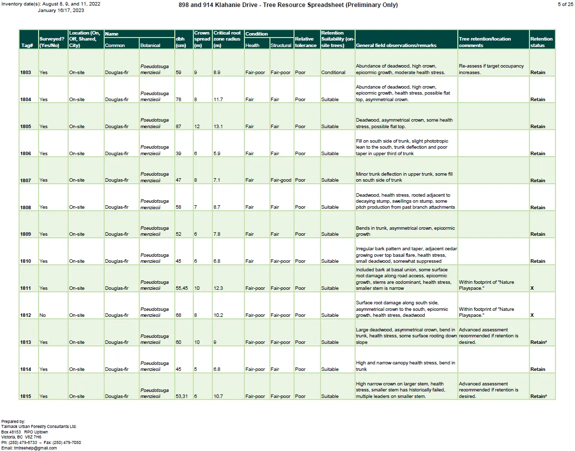
spreadsheet page - Page 5 (Tag numbers approx. 1803–1815):
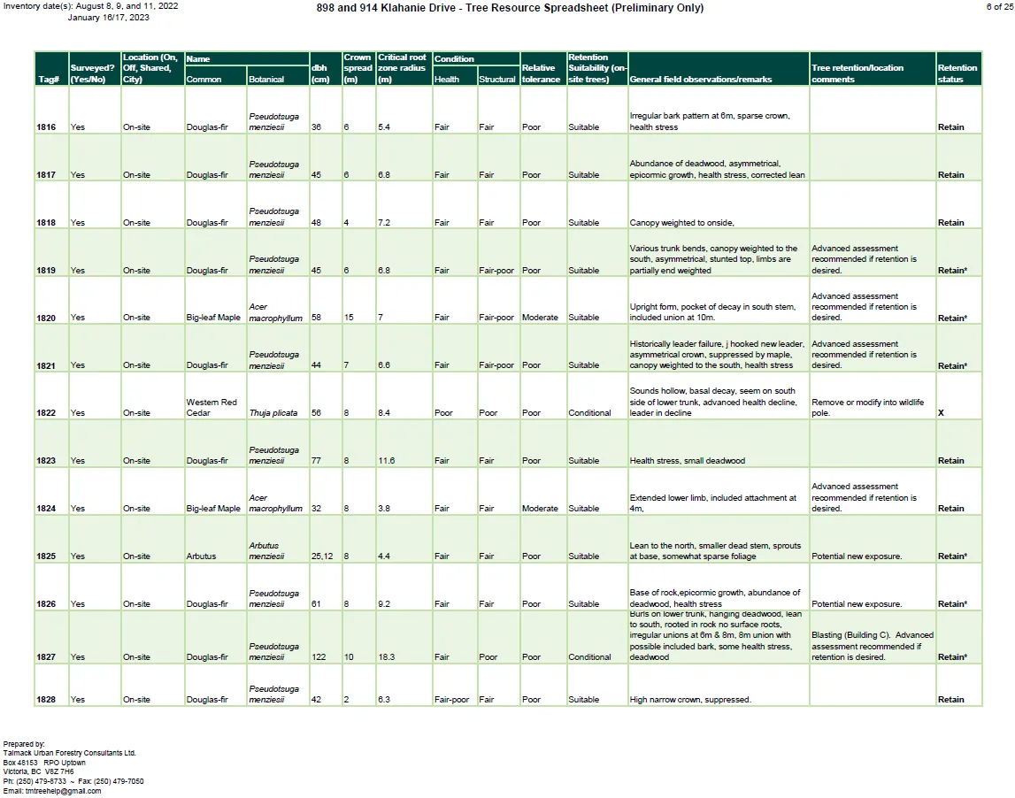
spreadsheet page - Page 6 (Tag numbers approx. 1816–1828):
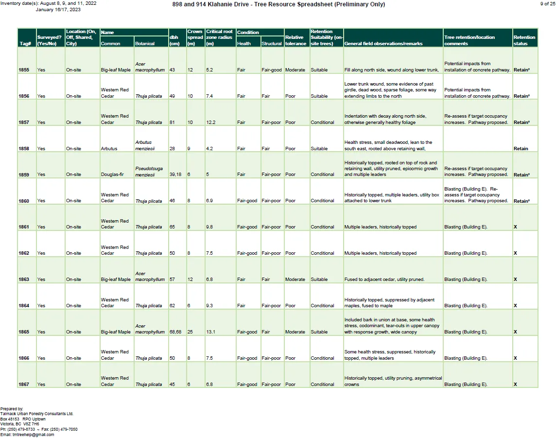
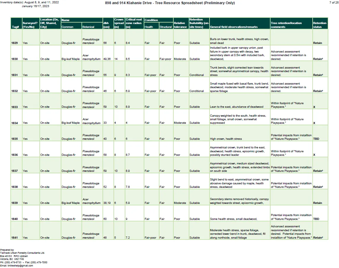
spreadsheet page - Page 7 (Tag numbers approx. 1829–1841):
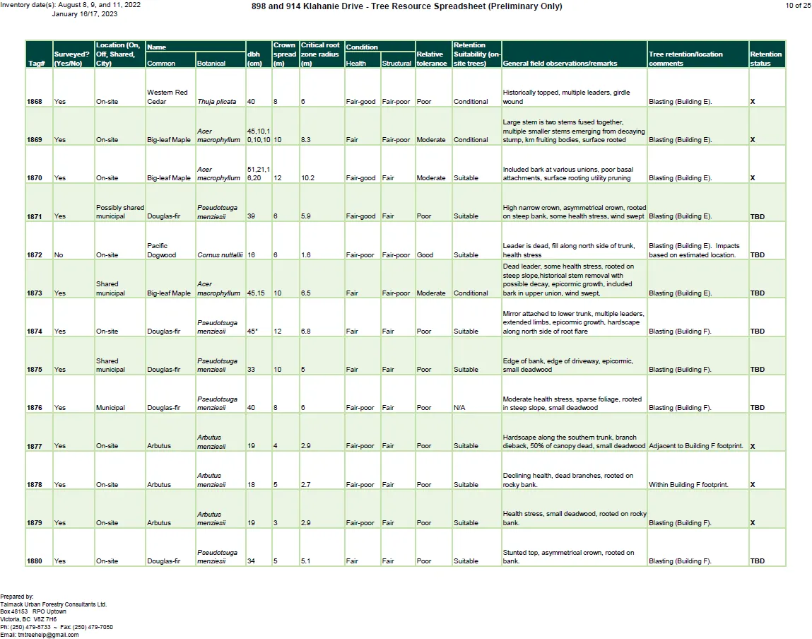
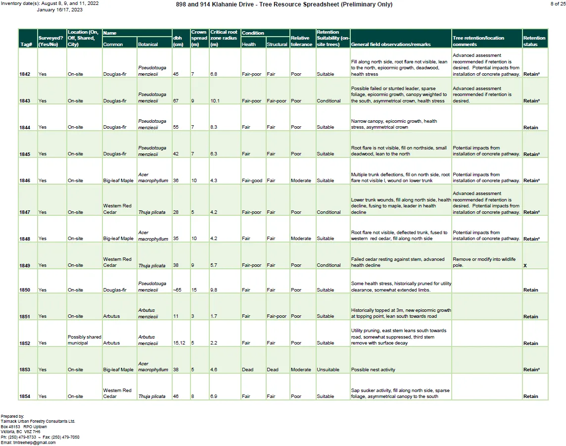
spreadsheet page - Page 8 (Tag numbers approx. 1842–1854):
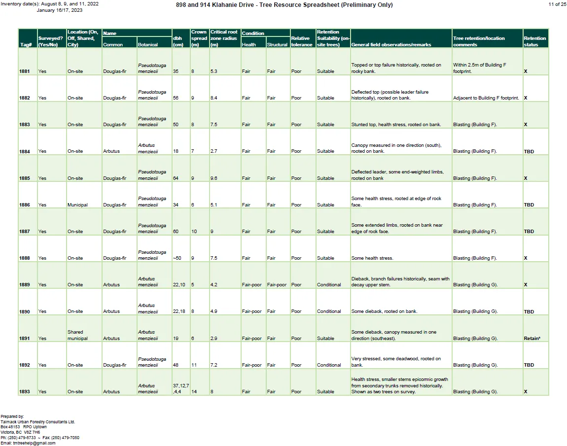
spreadsheet page - Page 9 (Tag numbers approx. 1855–1867):
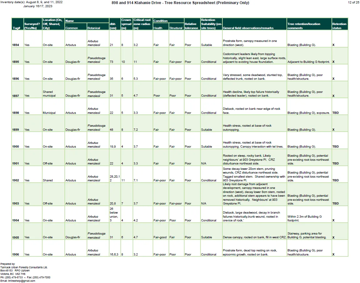
spreadsheet page - Page 10 (Tag numbers approx. 1868–1880):
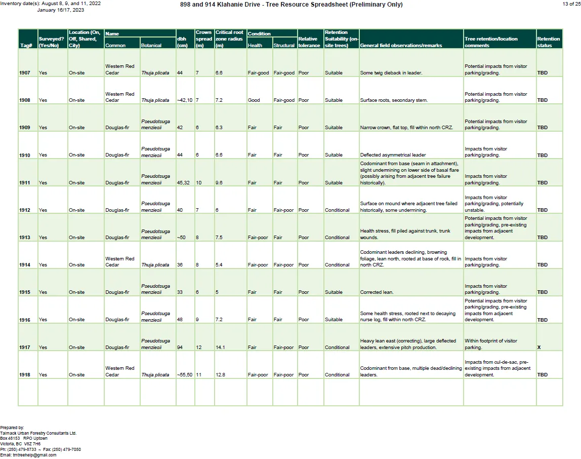
spreadsheet page - Page 11 (Tag numbers approx. 1881–1893):
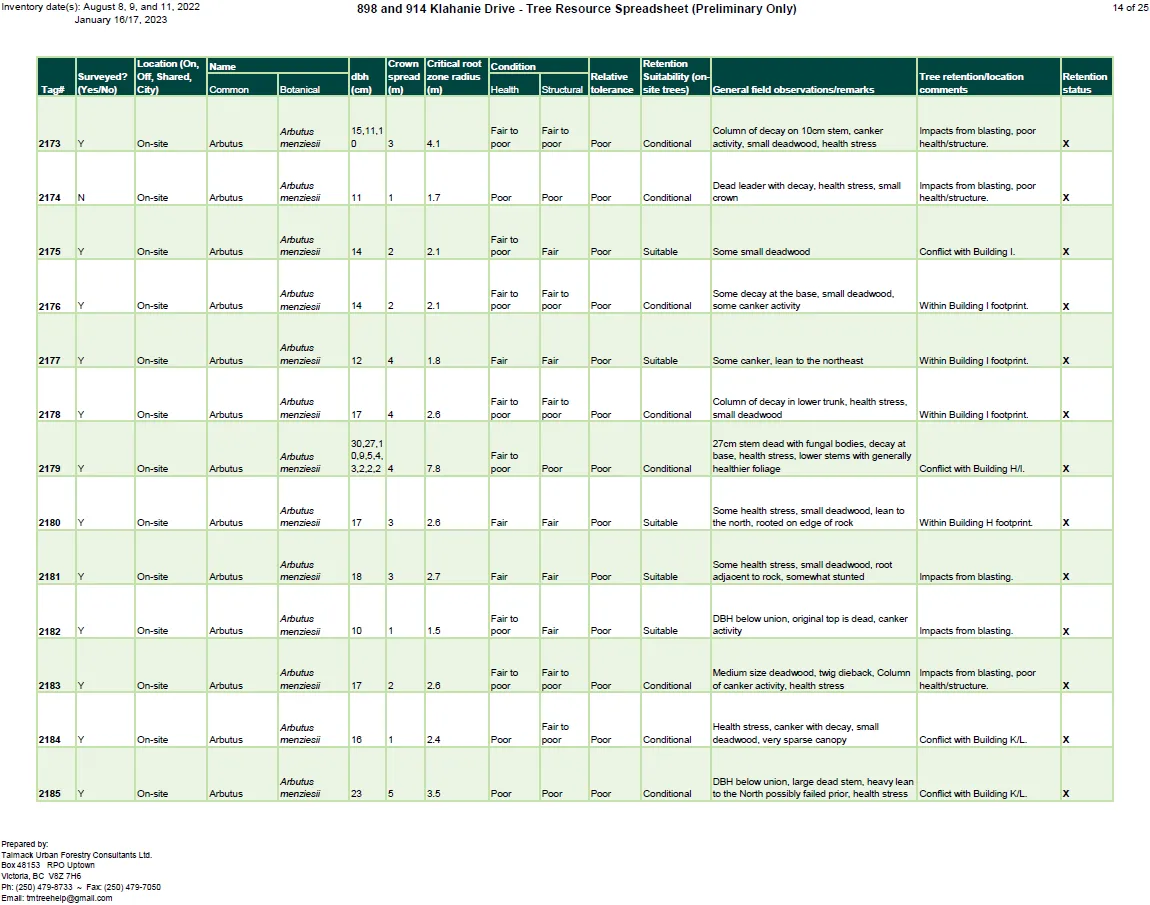
spreadsheet page - Page 12 (Tag numbers approx. 1894–1906):
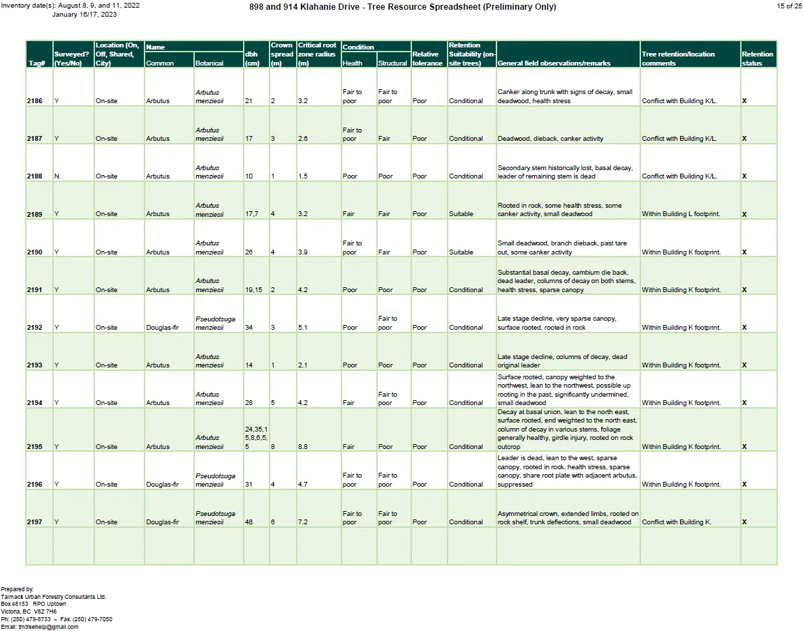
spreadsheet page - Page 13 (Tag numbers approx. 1907–1918):
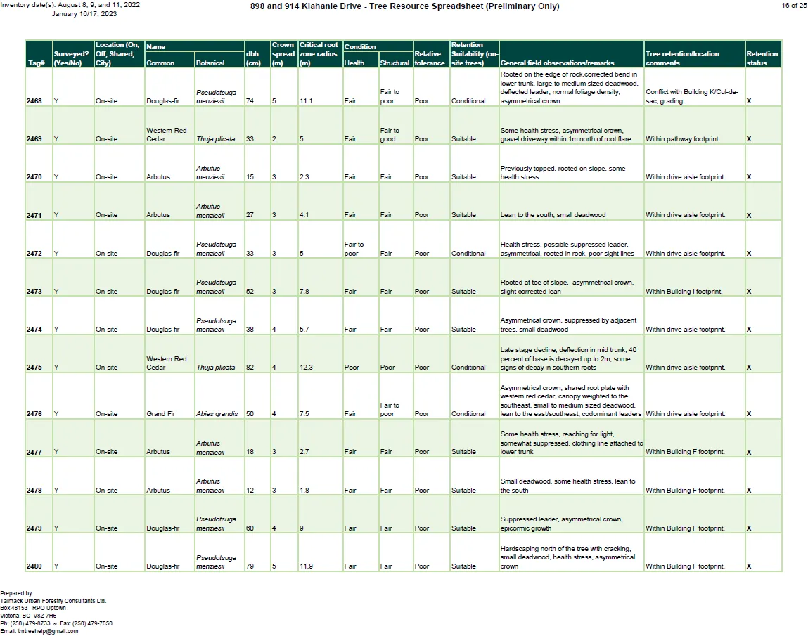
spreadsheet page - Page 14 (Tag numbers approx. 2173–2185):
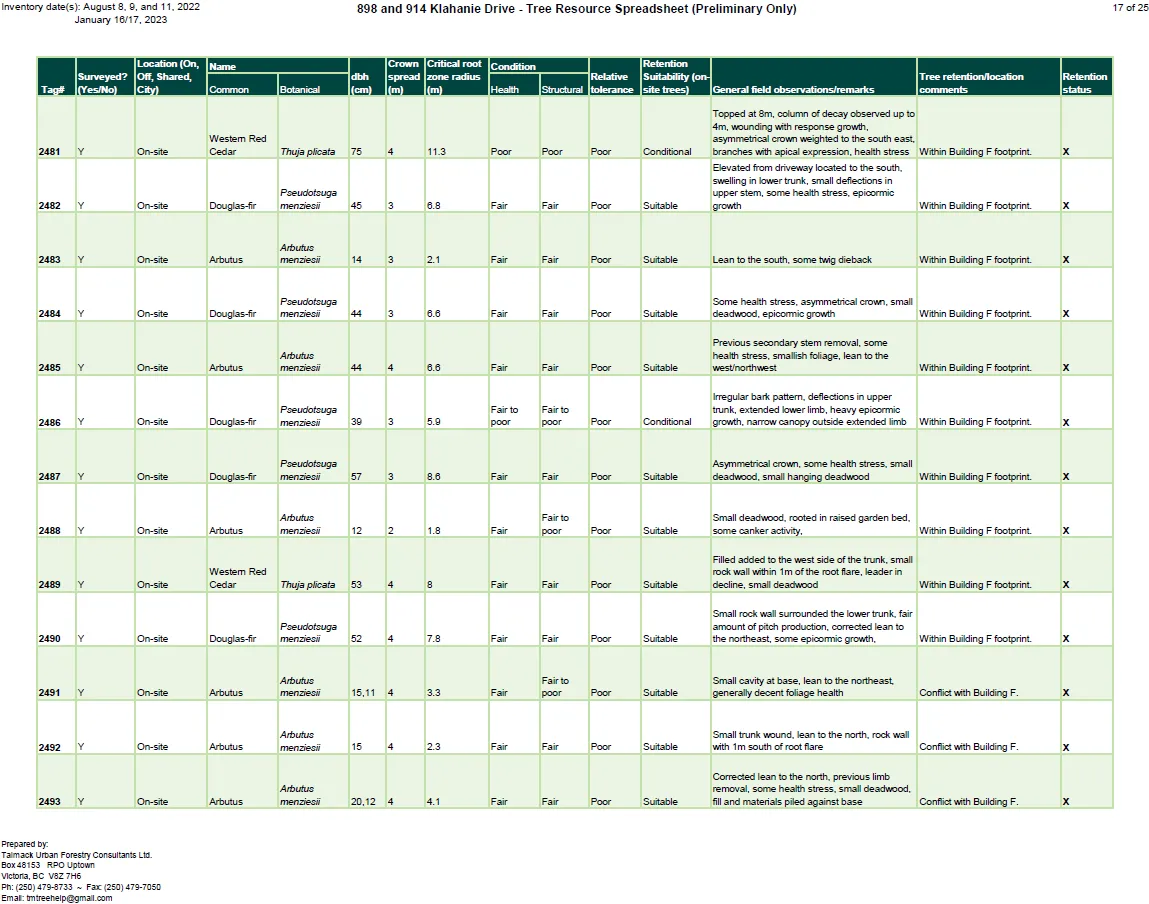
spreadsheet page - Page 15 (Tag numbers approx. 2186–2197):
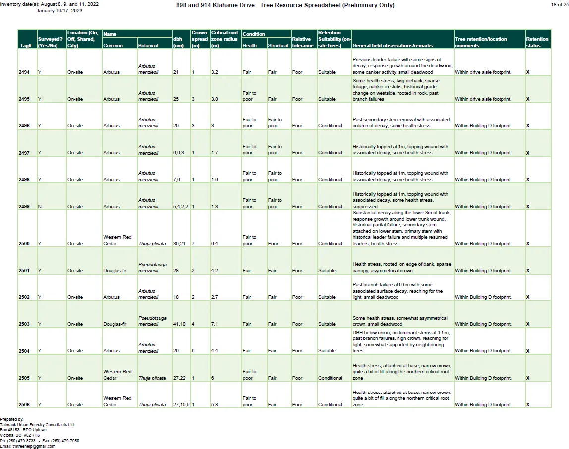
spreadsheet page - Page 16 (Tag numbers approx. 2468–2480):
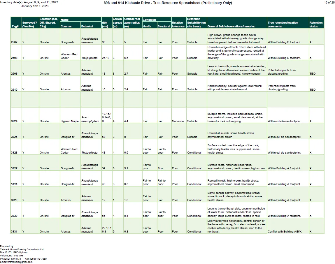
spreadsheet page - Page 17 (Tag numbers approx. 2481–2493):
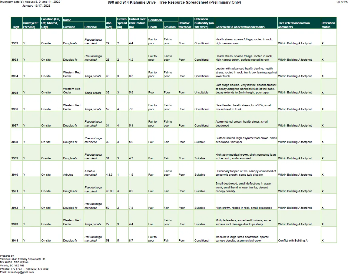
spreadsheet page - Page 18 (Tag numbers approx. 2494–2506):
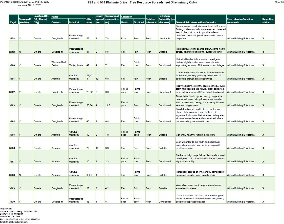
spreadsheet page - Page 19 (Tag numbers approx. 2507–3931):
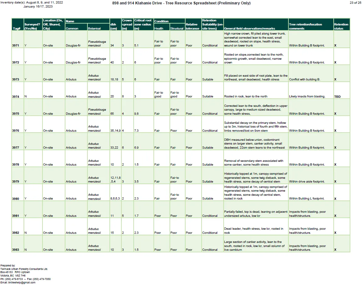
spreadsheet page - Page 20 (Tag numbers approx. 3932–3944):
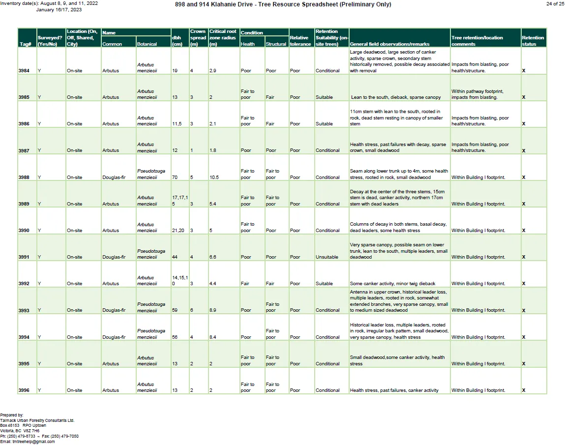
spreadsheet page - Page 21 (duplicate/repeat of some rows 3932–3944):
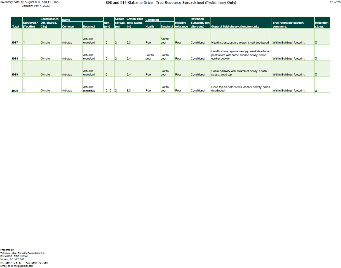
spreadsheet page - Page 22 (Tag numbers approx. 3958–3970):
spreadsheet page - Page 23 (Tag numbers approx. 3971–3983):
spreadsheet page - Page 24 (Tag numbers approx. 3984–3996):
- Page 25 (Tag numbers approx. 3997–4000):
Each image contains the detailed row-level observations and retention recommendations for each tree. The "Retention status" column includes codes such as "X", "Retain", "Retain*", "TBD", "Unstable", and other notations found in the spreadsheet. Many rows include notes about blasting exposure, new exposure, building footprints, driveways, and specific root/crown/structural issues.
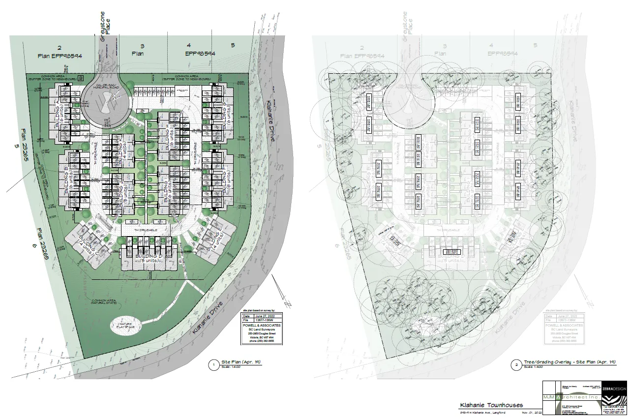
Site Plan and Tree/Grading Overlay
- The master site plan images show the proposed townhouse layout, driveways, cul-de-sac, pathways, planting areas, and the tree retention/grading overlay.
- The plan sheets show the relationship between proposed building footprints and existing tree locations; many tree records in the spreadsheet reference these building footprints (e.g., "Within Building A footprint", "Impacts from Building F", "Within Building G footprint", etc.).
Notes / Observations (as presented in the spreadsheet images)
- Many trees are described as having various degrees of health stress, epicormic growth, deadwood, root exposure (rooted next to rock or in fill), and historical topping or trunk defects.
- Several trees are noted as impacted or likely impacted by blasting, new exposure, excavation, driveways, stairways, or proposed building footprints.
- Several rows indicate "Advanced assessment recommended if retention is desired" for specific trees.
- Retention suitability classifications include: Suitable, Conditional, Unsuitable.
- Retention statuses include: X (likely for removal), Retain, Retain*, TBD, Unstable, and other notes.
Contact / Prepared By (repeated)
Tamaki Urban Forestry Consultants Ltd.
Box 48153, RPO Uptown
Victoria, BC V8Z 7H6
Ph: (250) 479-8733 — Fax: (250) 479-7050
Email: timtreeshelp@gmail.com
End of extracted content for pages 1–27 (Tree Resource Spreadsheet pages 1–25 and site plan images).