DocumentsStaff ReportMar 15, 2021Pages 39–50
Staff Report - Bylaw No. 1970 - Application to Rezone 757 and 765 Latoria from RR6A and RR2 to R2 (Z19-0025)
Staff report recommending consideration of Bylaw No.1970 to rezone 757 & 765 Latoria Road to R2 to allow a bare-land strata subdivision of approximately 28 single-family lots.
Key facts
- Subject addresses: 757 and 765 Latoria Road
- Site area (combined): 16,238.9 m2
- Proposal: subdivision of approximately 28 single-family lots (R2, strata lot averaging)
- Policy amenity contributions estimated: total approx. $242,808 (General Amenity, Affordable Housing and open space cash-in-lieu)
Staff Report - Bylaw No. 1970 - Application to Rezone 757 and 765 Latoria from RR6A and RR2 to R2 (Z19-0025)
Date
March 8, 2020
Department
Planning
Application No.
Z19-0025
Subject
Bylaw No. 1970 - Application to Rezone 757 and 765 Latoria from RR6A and RR2 to R2 to Allow for the subdivision of 28 single family lots.
PURPOSE
Brant and Sandra Hoff have applied on behalf of Sylvia and Shane Jamieson to rezone 757 and 765 Latoria Road from RR6A (Rural Residential 6A) and RR2 (Rural Residential 2) to R2 (One- and Two-Family Residential) to allow for the subdivision of 28 single family lots.
BACKGROUND
Previous Applications
- Z13-0018 - In May of 2014 757 Latoria was rezoned by Mike Ballard on behalf of the former owners from RR2 (Rural Residential 2) to RR6A (Rural Residential 6A). This was done in order to allow for a nine lot single family residential subdivision with a minimum lot size of 550 m2 and permitting secondary suites. At the time, Council asked for 30% dedicated greenspace. A Statement of Conditions was issued in 2016 but the original applicant never pursued it and the lot was never subdivided.
Table 1: Site Data
| Item | Details |
|---|---|
| Applicant | Brant Hoff |
| Owner | Brant and Sandra Hoff, Sylvia and Shane Jamieson |
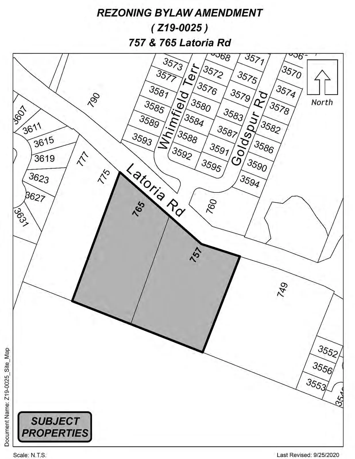
| Civic Address | 757 Latoria Road and 765 Latoria Road |
| Legal Description | LOT 1, SECTION 70, METCHOSIN DISTRICT, PLAN 22654 and LOT A, SECTION 70, METCHOSIN DISTRICT, PLAN 22796 |
| Size of Property | 16,238.9 m2 (combined total) |
| DP Areas | Habitat and Biodiversity, Riparian, Steep Slopes, High Interface Fire Hazard |
| Zoning Designation | RR6A (Rural Residential 6) |
| OCP Designation | Hillside and Shoreline |
SITE AND SURROUNDING AREA
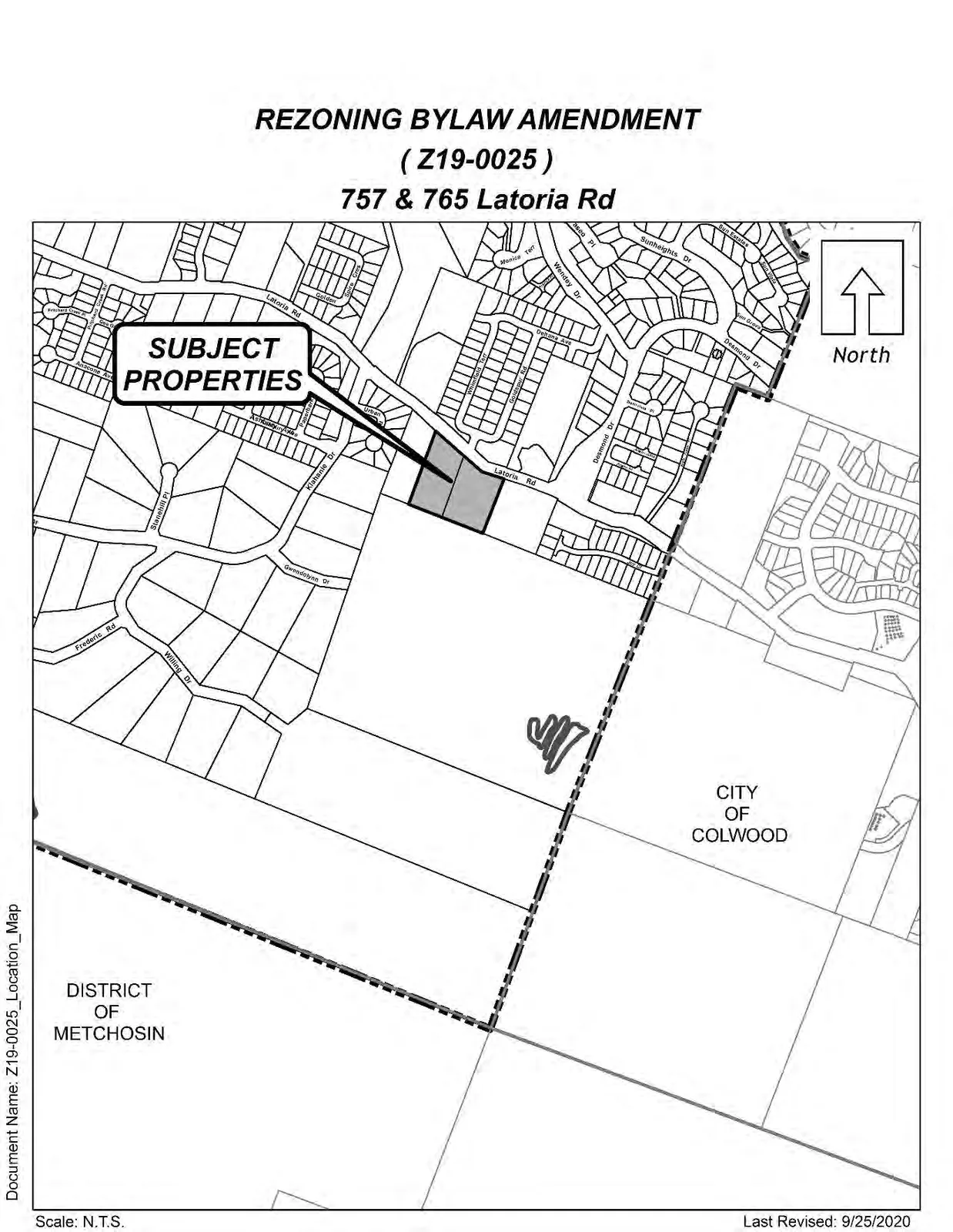
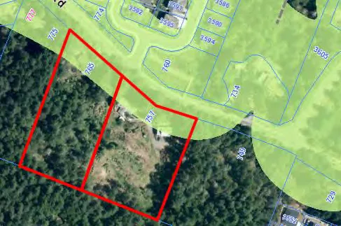
The subject properties are each currently occupied by a single family dwelling, with a large detached garage and parking area on 757 Latoria. The lots rise steeply from Latoria Road at a gradient of approximately 25 – 35%. Due to the steep topography, landings have been created to accommodate existing buildings. Along the Latoria frontage there is an existing vegetated buffer consisting of mature Douglas fir and Cedar trees which form a visual buffer from the road. Beyond the road buffer, the site at 757 Latoria has been disturbed and there are very few trees remaining apart from the rear property line. It appears the previous owner cleared much of the lot without approval through a development permit. The site at 765 Latoria has many large trees growing between the existing dwelling and rear property line. The surrounding area has undergone significant change over the past several years with many new subdivisions along Latoria Road. A future elementary school is slated to be built approximately 200 meters away at 802 Latoria Road.
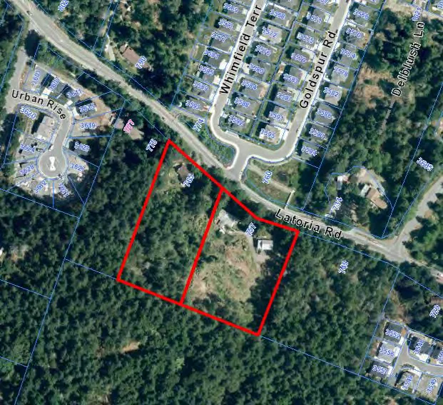
Table 2: Surrounding Land Uses
| Direction | Zoning | Use |
|---|---|---|
| North | RR6A (Rural Residential 6A) | Single Family Dwellings |
| East | CD4 (Comprehensive Development 4 – Olympic View) | Currently undeveloped – zoned for a comprehensive development consisting of a mix of commercial and residential uses of various densities |
| South | CD4 (Comprehensive Development 4 – Olympic View) | |
| West | RR2 (Rural Residential 2) | Single Family Dwelling |
OFFICIAL COMMUNITY PLAN
The subject property is designated as Hillside or Shoreline within the Official Community Plan Bylaw No. 1200 as described below:
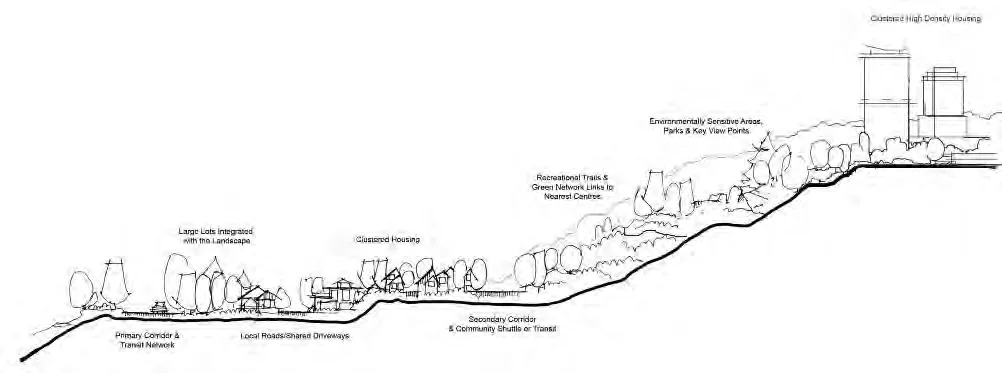
Hillside or Shoreline Predominantly existing low intensity settled areas throughout community with a high percentage of open space and undeveloped areas located on a hillside or near the shoreline.
- Predominantly residential precinct that supports a range of clustered low, medium and high density housing choices including secondary suites. Higher building forms, such as point towers, will be permitted on hillsides to maximize open space provided some conditions are satisfied (see policies for this area)
- Schools, community facilities and other institutional uses are permitted throughout the area
- Home-based businesses, live-work housing is encouraged; Home-based accommodations (e.g. Bed & Breakfasts) are permitted.
- Parks, open spaces and green corridors (creeks, wildlife corridors, trails, etc.) are integrated throughout the area. Large playfields are discouraged due to grading requirements. Site and topographic responsive pocket parks, enhanced viewpoints, graded hiking and walking trails, children’s play areas, including ‘tot lots’ and outdoor exercise areas are strongly encouraged on hillside areas.
- This area allows for Neighbourhood Centres to emerge in the form of high and medium density clustered mixed-use nodes
- Transit stops are located where appropriate
SOUTH LANGFORD NEIGHBOURHOOD PLAN (SLNP)
The South Langford Neighbourhood Plan (SLNP) designates the subject parcels as Suburban Residential.
Suburban Residential – applies to areas where the availability of municipal services allows for one- and two-family residential dwellings at densities that are similar to areas of existing, conventional (not small lot) residential development in Langford. A minimum lot size of 550 m2 (5920 ft2) is applicable.
COMPLIANCE WITH THE OCP AND SLNP
While the OCP does not provide an overall density for the Hillside and Shoreline designation, it does support a range of housing options including low and high density clustered development. The applicant is proposing lots with an average of 400 m2 which falls short of what the SLNP suggests. Council may wish to note that the SLNP has not been updated since 2006.
DEVELOPMENT PERMIT AREAS
Portions of the properties reside in the Riparian, Steep Slopes, Areas of Potential Habitat and Biodiversity, and High Interface Fire Hazard Development Permit Areas. Reports prepared by registered professionals and a Development Permit will be required prior to alteration of the land on the properties. The Riparian area extends along the front of both properties from a stream that runs along the other side of Latoria Road. Additionally, Council designates any lots less than 550 m2 in area as small lots and therefore the proposed development would also require a Form and Character Development Permit as it is deemed Intensive Residential.
COMMENTS
DEVELOPMENT PROPOSAL
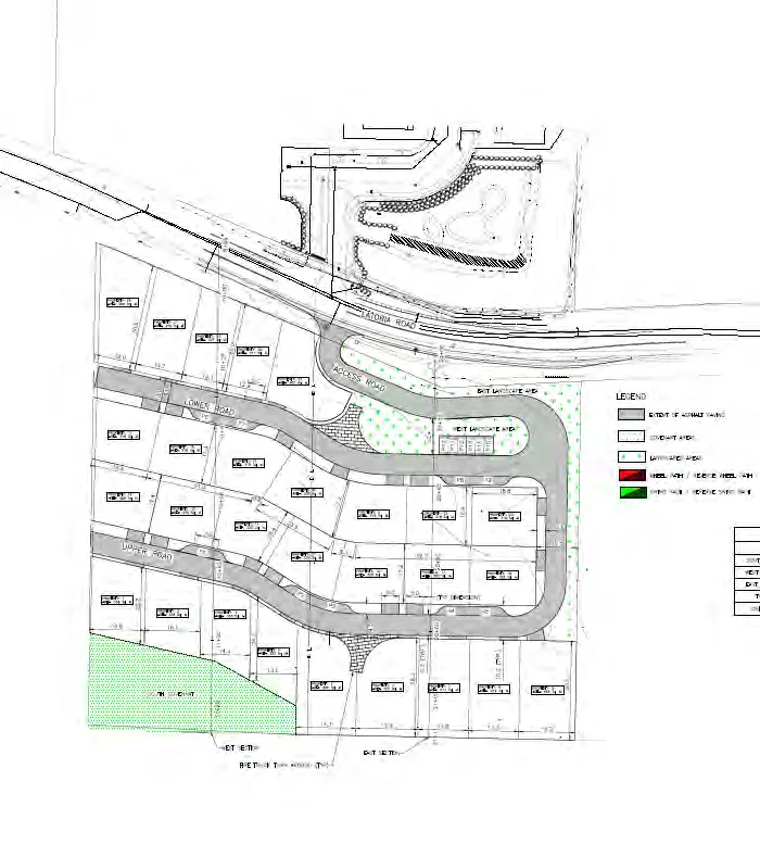
The applicant is proposing to subdivide and construct approximately 28 single family homes under the R2 (One- and Two-Family Residential) Zone within a bare land strata. The site access would occur via a strata road coming off Latoria where the existing driveway to 757 Latoria is located. Along with the 28 proposed single family lots, the applicant is proposing 14.2% of the land as open space. The applicant intends to utilize “strata lot averaging” which means that the average size of the lots would equal a minimum of 400 m2, meeting the R2 zoning requirements. Strata lot averaging is a practice commonly used on bare land strata developments that allows for some lots to be smaller than the minimum lot size if the overall density stays the same by being balanced out by other larger lots and common property open space (not including road access). In this case, the applicant intends to have a range of lot sizes to provide a range in price points. The applicant is proposing lots between 317 m2 and 507 m2. Council may wish to note that although the R2 zone allows for suites, it only allows for them on lots over 400 m2, so any lots created less than that through strata lot averaging would not be eligible to have one. The applicant has proposed that 8 of the lots would be over 400 m2 and would be constructed with a suite. The applicant has not requested any variances.
Council may wish to note that the existing zoning designation of 757 Latoria, the RR6A Zone, is similar to the proposed R2 zoning which can be shown below in Table 3.
Table 3: Proposal Data
| Permitted by RR6A (Current Zoning) | Permitted by R2 (Proposed) |
|---|---|
| Density (FAR and/or min. lot size) | 550 m2 minimum lot size with suites |
| Lot width | 14 m |
| Height | 9 m |
| Site Coverage | 50% |
| Front Yard Setback | 4.5 m or 5.5 m for a garage |
| Interior Side Yard Setback | 1.5 m |
| Exterior Side Yard Setback | 3 m or 5.5 m for a garage |
| Rear Yard Setback | 5.5 m |
| Parking Requirement | 2 parking spaces per principle dwelling + 1 parking space per suite |
In addition to providing two parking spaces per principle dwelling plus a third space for a suite, the applicant will be required to create one street parking space for every two new lots created. Given that the applicant is proposing 28 lots, a minimum of 14 street parking spaces shall be constructed. On the current plan, the applicant is demonstrating a total of 15 street parking spaces.
OPEN SPACE PRESERVATION
As noted previously, the applicant intends for 14.2% of the land to be open space (shown on Appendix A). This area is proposed as strata common property with approximately half being saved in a natural state in the southwestern corner of the development, and the other half being a replanted landscape area on the portions of land previously disturbed. Council may wish to ask that a landscape plan for the replanted area is provided at the time of development permit to ensure adequate planting is completed. The area in the southwest corner is heavily treed and in a steep area that would not be blasted during the land preparation for the lots which could be secured through a non-disturbance covenant. As noted, 757 Latoria has been previously cleared by a past owner without City consent resulting in very few existing trees, which is why the applicant is planning to replant some of this area. The applicant has agreed to make an additional cash-in-lieu payment of $113,448 which is equal to the value of approximately 5.8% of the land. This brings the applicant’s total open space contribution to 20%.
For neighbourhood context, Council may wish to be aware of the open space contributions made in surrounding developments. The Latoria neighbourhood has a history of providing 30% open space at the time of rezoning, but the two most recent rezoning applications in the area, 734 Latoria and 790/794 Latoria, have each given 17% open space in either land or cash-in-lieu. It should be noted that at the time of this report, 790/794 Latoria has received 2nd and 3rd reading, but not final bylaw adoption. Given this, Council may deem is appropriate to accept 20% open space in the form of 14.2% preserved open space, and 5.8% as cash-in-lieu.
PEDESTRIAN, CYCLING AND MOTORIST NETWORK
BC Transit bus stops located near the subject site provide service on Routes 48, 54, 55, 59 and 60 to the Langford Exchange and Metchosin. Most of these routes only run once per hour or two, with increased service during peak commuting hours. Many of the routes do not run on weekends or have a further reduced schedule.
STORMWATER MANAGEMENT
The applicant will be required to provide a stormwater management plan to the satisfaction of the Director of Engineering prior to subdivision approval or the issuance of a building permit, whichever is first. Council may wish to require a stormwater technical memo prepared by the project engineer prior to Public Hearing to verify that storm water can be adequately managed on-site for the proposed development.
FRONTAGE IMPROVEMENTS
The applicant will be required to provide full frontage improvements in accordance with Bylaw 1000, prior to subdivision approval or the issuance of a building permit, whichever is first.
CONSTRUCTION PARKING MANAGEMENT PLAN
Council may wish to require a Construction Parking Management Plan as a condition of rezoning and require that it be provided to the satisfaction of the Director of Engineering prior to any land alteration. This should be secured within a covenant, prior to Bylaw Adoption.
POTENTIAL NUISANCES
As has been past practice in the South Langford area, Council may wish to require the applicant to provide a Section 219 Covenant registered on title prior to Bylaw Adoption that provides future property owners with the understanding that a variety of agricultural uses and the South Vancouver Island Rangers gun range are located within approximately 1.5 km of this site, that these pre-existing uses may result in general nuisances and that future landowners understand and accept the potential disruption to their residential occupancy of the site.
FINANCIAL CONTRIBUTIONS
Rezoning the subject property to permit higher density may increase the assessed value of the property, and this may increase municipal revenue. As the applicant will be responsible for frontage improvements and connection to the municipal sewer system, the direct capital costs to the municipality associated with this development will be negligible. A summary of the Amenity Contributions and Development Cost Charges that the developer will be expected to pay is outlined below in Tables 4 and 5.
Table 4 – Amenity Contributions per Council Policy
| Amenity Item | Per lot contribution | Total (for 28 lots) |
|---|---|---|
| General Amenity Reserve Fund | $3,960 per lot | $110,880 |
| Affordable Housing Reserve Fund | $660 per lot | $18,480 |
| Open Space Contribution | Equivalent to 5.8% of the lot area | $113,448 |
| TOTAL POLICY CONTRIBUTIONS | $242,808 |
Table 5 – Development Cost Charges
| Development Cost Charge | Per lot contribution | Total (for 28 lots) |
|---|---|---|
| Roads | $6,056 per lot | $169,568 |
| Storm Drainage | $1,878 per lot | $52,584 |
| Park Improvement | $1,890 per lot | $52,920 |
| Park Acquisition | $1,100 per lot | $30,800 |
| Incremental Storage Improvement Fees | $371.25 per lot | $10,395 |
| Subtotal (DCCs paid to City of Langford) | $316,267 | |
| CRD Water | $2,922 per unit | $81,816 |
| School Site Acquisition | $1000 per unit | $28,000 |
| TOTAL (estimate) DCCs | $426,083 |
OPTIONS
Option 1
That the Planning, Zoning and Affordable Housing Committee recommend that Council:
- Proceed with consideration of Bylaw No. 1970 to amend the zoning designation of the property located at 757 and 765 Latoria Road from RR6A (Rural Residential 6A) and RR2 (Rural Residential 2) to R2 (One- and Two-Family Residential) subject to the following conditions:
a) That the applicant provides, as a bonus for increased density, the following contributions per lot prior to subdivision approval:
i. $660 towards the Affordable Housing Fund; and
ii. $3,960 towards the General Amenity Fund.
b) That the applicant provides $113,448 to the General Amenity Reserve Fund in lieu of 5.8% open space, prior to subdivision approval;
c) That prior to Public Hearing, the applicant provides a technical memo from an engineer that verifies stormwater can be adequately managed on-site for the proposed developments, to the satisfaction of the Director of Engineering;
d) That the applicant provides, prior to Bylaw Adoption, a Section 219 covenant, registered in priority of all other charges on title, that agrees:
i. That the following will be provided and implemented to Bylaw No. 1000 standards to the satisfaction of the Director of Engineering prior subdivision approval or the issuance of a building permit, whichever is first:
i. Full frontage improvements; and
ii. A storm water management plan;
ii. That a Construction Parking and Traffic Management Plan be provided to the satisfaction of the Director of Engineering prior to any alteration of the land;
iii. That 2,298.7 m2 of the land shall be retained as open space, with a non-disturbance covenant registered for 1,225.7 m2 of land in the southwest corner of 765 Latoria Road prior to subdivision approval;
iv. That a landscape plan shall be provided at the time of development permit for the portion of open space intended to be re-planted; and
v. That the site is in proximity to agricultural areas and the South Vancouver Island Rangers gun range, and that these may create general noise, odour, and other nuisances, and agree that the owner and all future owners assume all risk and annoyance of such nuisances.
OR Option 2
- Take no action at this time with respect to Bylaw No. 1970
Submitted by
Julia Buckingham, Planner I - Approved
Concurrence
- Matthew Baldwin, MCIP, RPP, Director of Planning - Approved
- Marie Watmough, Manager of Legislative Services - Approved
- Chris Aubrey, Fire Chief - Approved
- Cory Manton, Manager of Parks and Recreation - Approved
- George Henshall, P.Eng, P.Geo, Director of Engineering - Approved
- Leah Stohmann, MCIP, RPP, Deputy Director of Planning - Approved
- Michael Dillabaugh, CPA, CA, Director of Finance - Approved
- Braden Hutchins, Director of Corporate Services - Approved
- Darren Kiedyk, Chief Administrative Officer - Approved
:jb
Appendices