DocumentsStaff ReportOct 5, 2020Pages 74–84
Staff Report - Application to Rezone 630 Strandlund Ave (RT1) (PZAH item)
Planning staff report recommending preparing a rezoning bylaw to rezone 630 Strandlund Ave from R2 to RT1 to allow a 10-unit townhouse development, including required contributions and conditions.
Key facts
- Proposal: 10-unit townhouse development
- Amenity contribution: $3,660 per unit
- Affordable housing contribution: $610 per unit
- Pre-Public Hearing requirement: stormwater technical memo to Director of Engineering
- Section 219 covenants for frontage and tree preservation
Staff Report — Application to Rezone 630 Strandlund Ave (Z20-0012)
Date: September 14, 2020
Department: Planning
Application No.: Z20-0012
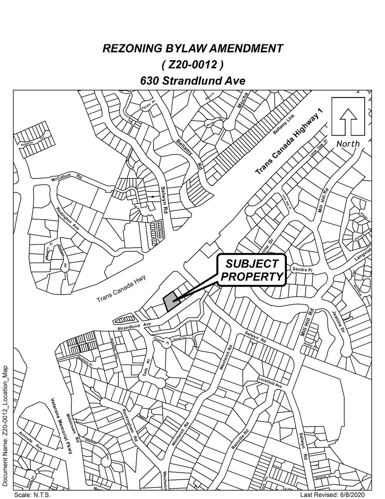
Subject: Application to Rezone 630 Strandlund Ave from One-and Two Family Residential (R2) to Residential Townhouse 1 (RT1), to allow for a 10-unit townhouse development.
PURPOSE
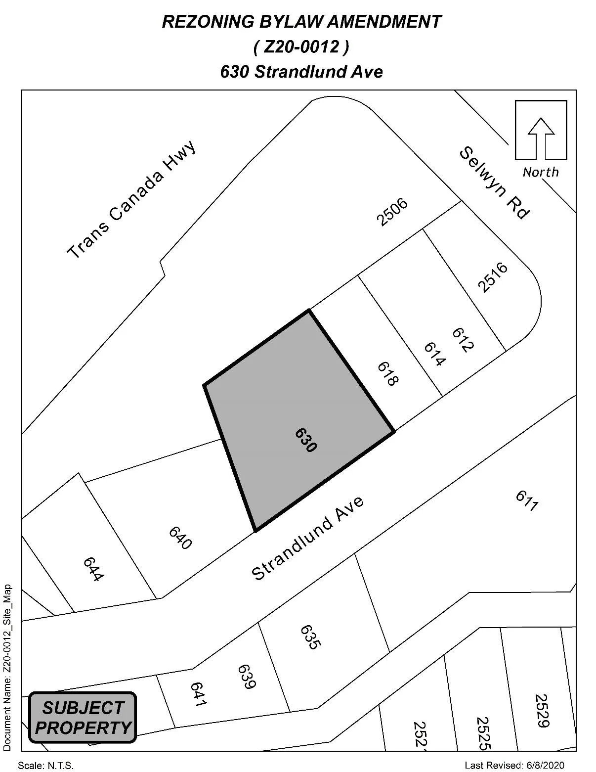
Mohammed Mehdi Khataw has applied on behalf of Ladkeen Canada Ltd. to rezone 630 Strandlund Avenue from One-and Two Family Residential (R2) to Residential Townhouse 1 (RT1), to allow for a 10-unit townhouse development.
BACKGROUND
Previous Applications
The City has not received any previous planning applications for the subject property.
Table 1: Site Data
| Item | Details |
|---|---|
| Applicant | Mohammed Mehdi Khataw |
| Owner | Ladkeen Canada Ltd. |
| Civic Address | 630 Strandlund Ave |
| Legal Description | Lot 9, Section 109, Esquimalt District, Plan 10723 |
| Size of Property | 1,583 m2 (0.39 acres) |
| DP Areas | N/A |
| Zoning Designation | Existing: One-and Two Family Residential (R2) — Proposed: Residential Townhouse 1 (RT1) |
| OCP Designation | Existing: Neighbourhood — Proposed: Neighbourhood |
SITE AND SURROUNDING AREA
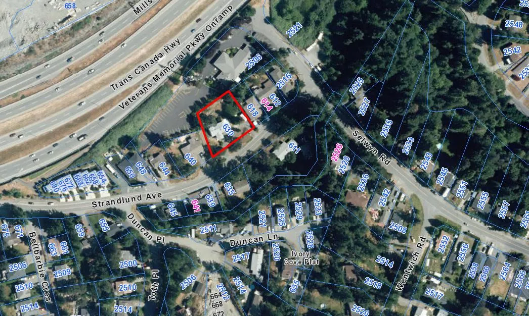
The subject property is currently occupied by a single-family dwelling in an area comprised of mostly single-family homes on lots greater than or equal to 550 m2, with some duplex and townhouse lots situated along Strandlund Avenue.
The lot to the east contains a newer single-family home on a 634 m2 lot, and the lot to the west contains an older (circa 1959) bungalow, on a 1,102 m2 lot. Directly across the street are larger single family lots ranging in size from 700 m2 to 1,500 m2. Parking for Knights Hall, Jehovah’s Witness, borders the northern property line, followed by the Trans Canada Highway.
Topographically, the site rises from grade at Strandlund Ave to approximately 5 m at the rear of the property. Elevated rock outcrop/cut rock is located at the front of the property.
Several mature Oak trees are located along the front of the property, within City Boulevard. The trees would be required to be saved as a condition of this development proposal.
Table 2: Surrounding Land Uses
| Zoning | Use |
|---|---|
| North — Neighbourhood Institutional (P1) | Institutional |
| East — One-and Two Family Residential (R2) | Single Family Dwelling |
| South — One-and Two Family Residential (R2) | Single Family Dwelling |
| West — One-and Two Family Residential (R2) | Single Family Dwelling |
COUNCIL POLICY
OFFICIAL COMMUNITY PLAN
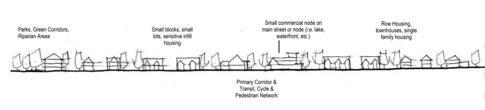
The Official Community Plan (OCP) Bylaw No. 1200 designated the subject properties as “Neighbourhood”, which is defined by the following text:
- Existing settled areas throughout the community predominantly located on the valley floor.
- Predominantly residential precinct that supports a range of low and medium density housing choices including secondary suites
- This area allows for residential and mixed use commercial intensification of streets that connect centres and/or are serviced by transit
- Schools, community facilities and other institutional uses are permitted throughout the area
- Retail serving local residents is encouraged along transportation corridors
- Home-based businesses, live-work housing is encouraged
- Parks, open spaces and recreational facilities are integrated throughout the area
- This area allows for Neighbourhood Centres to emerge in the form of medium density mixed-use nodes at key intersections.
Amending the zoning designation of the subject property from R2 to RT1 to allow for a townhouse development would align with current OCP policy that envisions small blocks, small lots and sensitive infill developments, including rowhouse, townhouse and small lot single family housing.
The density of the development (10 units/0.39 acres) is greater than the overall density objective of the Neighbourhood OCP designation for infill sites, which contemplates a density objective of 16 units/acre. However, this objective is intended to be used to guide choices about density in Neighbourhood areas, rather than be applied as a strict density limit.
DEVELOPMENT PERMIT AREAS
The subject property is not located within any hazardous or environmental development permit areas, however a development permit to evaluate form and character will be required prior to building permit issuance.
DEVELOPMENT PROPOSAL
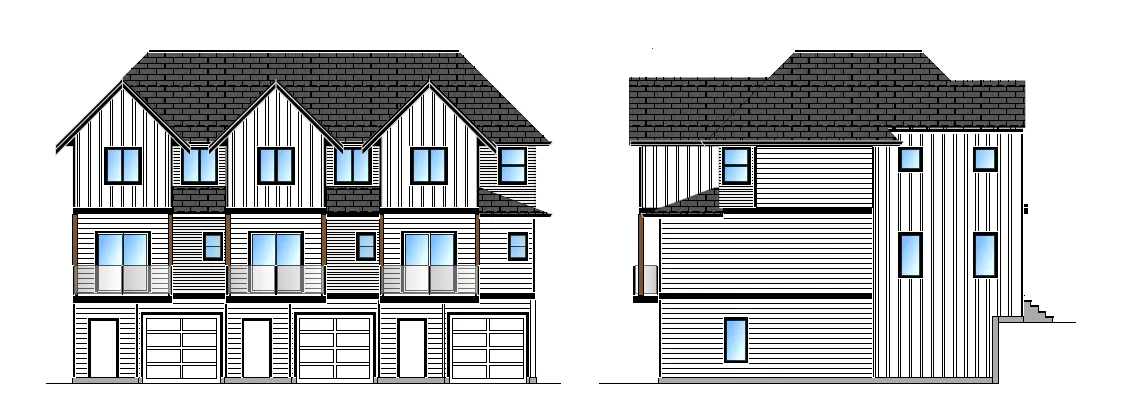
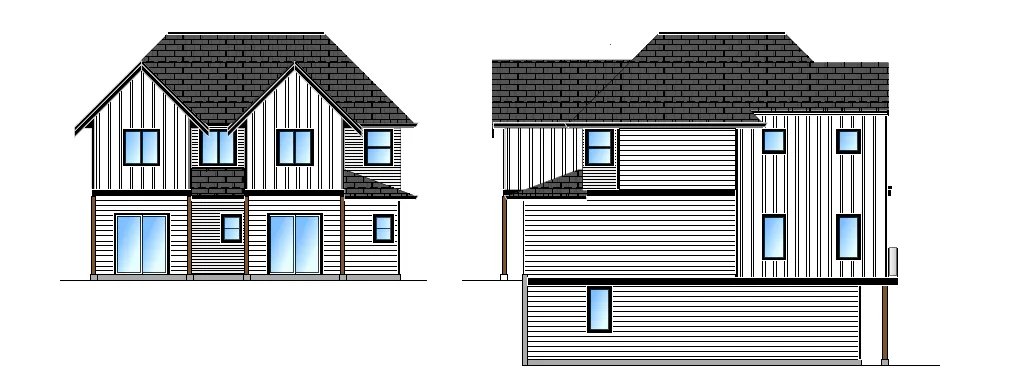
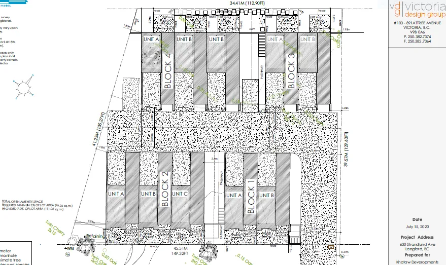
The applicant is proposing to rezone the property to allow for the construction of 10 townhouse units within four separate townhouse blocks. Each townhouse block is proposed to be three storeys in height with peaked roofs, black trim boards, vertical board and batten siding, walk-out patios, and balconies.
The proposal generally meets the guidelines for multi-family residential development; however a more thorough review of the design and layout of the units will be completed during the Form and Character Development Permit review process, and additional changes may be required. Staff have noted that the balconies of the townhouse units may overlook portions of the yards of adjacent single-family lots, which may trigger additional landscape screening or grade differentiation to mitigate the visual impact on the neighbouring properties. Typically, as per the multi-family development permit guidelines, driveways shall be set back a minimum of 1.0 m (3.3 ft.) from any interior side lot line. The developer is proposing a 0.67 m driveway setback from the interior property line. In addition, the developer is requesting a variance to the front and rear lot lines. However, due to the expansive boulevard, the presence of mature Oak trees in the frontage of the property, and additional landscape screening, there may be an impression of a larger setback from the road than what is proposed. Furthermore, as the rear property line adjoins the parking lot for Knight’s Hall, the rear setback reduction should not have a significant impact.
If Council supports the building setback variances, they may wish to authorize the Director of Planning to issue the above noted variance within the Form and Character Development Permit.
ACCESS, PARKING AND FRONTAGE IMPROVEMENTS
Access to the site will be along the east property boundary with parking at the rear of the units fronting Strandlund, providing a “walk-up” street presence.
Resident parking will be provided in accordance with Section 4.01 of Zoning Bylaw 300 with 2 stalls for each unit, of which one is proposed to be enclosed. No on-street parking is required.
Staff have noted that the proposed parking arrangement, which includes a single car driveway leading into a single car garage, has historically resulted in an increase in on-street parking due to residents using the enclosed parking area as storage or hobby space. Once residents start using the space for storage, the parking garage becomes much less functional. As a result, Council may wish to require the developer register a section 219 covenant requiring the garage to be used for the primary purpose of parking.
Table 3: Proposal Data
| Permitted in R2 Zone (Current Zone) | Permitted by RT1 Zone | Proposed |
|---|---|---|
| Density | N/A | 1.2 FAR |
| Height | 9.0 m | 10.0 m |
| Site Coverage | 35% | 60% |
| Front Yard Setback | 6.0 m | 3.0 m |
| Interior Side Yard Setback | 1.5 m | 1.2 m |
| Rear Yard Setback | 6.0 m | 5.5 m |
| Parking Requirement | 2 per dwelling |
*Variance required
PARKS AND BOULEVARD
No planting of boulevard trees or construction of municipal irrigation is required; however, the Parks Department has requested the protection and retention of the existing Oak trees at the frontage of the property. Tree protection fencing is required to be installed prior to construction and maintained until completion/final approvals.
PEDESTRIAN, CYCLING AND MOTORIST NETWORK
The applicant will be required to install a bike lane and extend the sidewalk fronting the property in accordance with Bylaw 1000 and to the satisfaction of the Director of Engineering. Streetlights may also be required.
Two bus routes are located within a five-minute walk of the subject property, including: #53 – Colwood Exchange/ Langford via Atkins; and #65 – Sooke/Downtown via Westhills.
SERVICING
Sewers
A sewer main exists within Strandlund Ave along the frontage of the development. Sewer connections, extensions and/or upgrades to existing infrastructure and the installation of new infrastructure will be the responsibility of the developer.
Drainage and Stormwater Management
Bylaw 1000 allows for stormwater to be managed through detention or infiltration, depending on what a qualified professional determines appropriate for the site. As a condition of rezoning, Council may wish to require a stormwater technical memo prior to Public Hearing from a qualified professional, to the satisfaction of the Director of Engineering. A formal stormwater management plan will be required prior to issuance of a building permit. The requirement for a stormwater management plan prior to building permit should be secured through a section 219 covenant.
Water Requirements
The developer will be required to meet the water supply requirements as per the Fire Underwriters Survey prior to issuance of the development permit. The Fire Underwriters Survey (FUS) calculations may determine different setbacks than was is prescribed in the zone or authorized through variance, and may dictate building materials or the requirement for additional fire protection measures.
FINANCIAL CONTRIBUTIONS
Rezoning the subject properties to permit higher densities will increase the assessed value of the lands and eventually increase municipal revenue due to the number of units created. As the developer is responsible to complete all frontage improvements, servicing connections and upgrades necessary to service the site, the direct capital costs to the City associated with this development will be negligible.
A summary of amenity contributions and development cost charges that the developer will be expected to pay, is outlined in Tables 4 and 6 below.
COUNCIL’S AFFORDABLE HOUSING AND GENERAL AMENITY CONTRIBUTION POLICY
Table 4 – Amenity Contributions per Council Policy
| Amenity Item | Per townhouse unit | Total @ 10 units |
|---|---|---|
| Affordable Housing Reserve Fund | $610 | $6,100 |
| General Amenity Reserve Fund | $3,660 | $36,600 |
| TOTAL POLICY CONTRIBUTIONS | $42,700 |
DEVELOPMENT COST CHARGES
Table 6 – Development Cost Charges
| Development Cost Charge | Per unit | Total @ 10 units |
|---|---|---|
| Roads | $3,985 | $39,850 |
| Park Improvement | $1,890 | $18,900 |
| Park Acquisition | $1,100 | $11,000 |
| Incremental Storage Improvement Fees | $371.25 | $3,712.50 |
| Integrated Survey Area | $35 (Total) | $35 |
| Subtotal (DCCs paid to City of Langford) | 73,497.50 | |
| CRD Water | $1,644 | $16,440 |
| School Site Acquisition | $628 | $6,280 |
| TOTAL (estimate) DCCs | $96,217.50 |
OPTIONS
Option 1
That the Planning, Zoning and Affordable Housing Committee recommend that Council:
- Direct Staff to prepare a bylaw to amend the zoning designation of the property located at 630 Strandlund Avenue from R2 (One-and Two Family Residential) to RT1 (Residential Townhouse 1), subject to the following terms and conditions:
a. That the applicant provide, as a bonus for increased density, the following contributions per dwelling unit, prior to issuance of a building permit:
i. $3,660 towards the General Amenity Reserve Fund
ii. $610 towards the Affordable Housing Reserve Fund
b. That the applicant provide, prior to Public Hearing, the following:
i. A technical memo from a qualified engineer that verifies stormwater can be managed on site, to the satisfaction of the Director of Engineering;
c. That the applicant provides, prior to Bylaw Adoption, a section 219 covenant, registered in priority over all other charges on title, that agrees to the following:
i. That the developer agrees to install, or bond for, all frontage improvements to Bylaw 1000 standards, and to the satisfaction of the Director of Engineering, prior to issuance of a building permit;
ii. That the Oak trees within the City boulevard are to be preserved, and delineated with tree protection fencing to the satisfaction of the Parks Manager, prior to commencement of works;
iii. That a stormwater management plan be provided and implemented, to the satisfaction of the Director of Engineering;
iv. That the applicant provide a construction management plan to the satisfaction of the Director of Engineering, prior to issuance of a building permit;
v. That the developer will connect and be responsible for any upgrades required to the services and utilities required to the development;
vi. That the developer will submit Fire Underwriters Survey (FUS) calculations prior to issuance of a development permit, and acknowledges that the calculations may determine different setbacks than what is prescribed in the zone or authorized through variance, and dictate building material or the requirement for additional fire protection measures including sprinkler protection or fire walls;
vii. That the enclosed parking garages for each unit are designated for parking of vehicles only and not replaced with storage or hobby space;
d. That Council authorize of the Director of Planning to issue the following variance within the Form and Character Development Permit for the subject property:
i. That section 6.28.07(1)(a) be varied to reduce the front lot line setback from the required 3.0 m to 2.13 m;
ii. That section 6.28.07(1)(d) be varied to reduce the rear lot line setback from the required 5.5 m to 3.29 m;
OR Option 2
- Take no action at this time with respect to rezoning the property.
Submitted by
David Sametz, Land Development Planner
Concurrence
- Matthew Baldwin, MCIP, RPP, Director of Planning
- Marie Watagon, Manager of Legislative Services
- Chris Aubrey, Fire Chief
- Lorne Fletcher, Manager of Community Safety and Municipal Enforcement
- Cory Manton, Manager of Parks and Recreation
- Michelle Mahovlich, P.Eng, P.Geo, Director of Engineering
- Leah Stohmann, MCIP, RPP, Deputy Director of Planning
- Michael Dillabaugh, CPA, CA, Director of Finance
- Braden Hutchins, Director of Corporate Services
- Darren Kiedyk, Chief Administrative Officer
:ds
APPENDICES
Appendix A
Appendix B
Appendix C