DocumentsStaff ReportMay 4, 2020Pages 128–139
Staff Report - Application to Rezone 721 - 769 Meaford Avenue from R1 to MUE4
Planning report regarding an application to rezone properties at 721–769 Meaford Avenue from R1 (One-Family Residential) to MUE4 (Mixed-Use Employment 4) to permit multi-family residential and/or commercial development.
Key facts
- Subject addresses: 721, 749, 755, 759, 767, 769 Meaford Ave (as referenced elsewhere)
- Proposed zoning: R1 to MUE4
- Agenda listing: Report start page 128
Staff Report to Council
Date: May 4, 2020
Department: Planning
Application No.: Z20-0005
Subject: Application to Rezone 721 - 769 Meaford Avenue from R1 (One-Family Residential) to MUE4 (Mixed-Use Employment 4) to Allow for Multi-Family Residential and/or Commercial Development
PURPOSE
Niall Paltiel of Keycorp Planning Ltd. has applied on behalf of C.R.M. Properties Ltd. to rezone 721-769 Meaford Avenue from R1 (One-Family Residential) to a new MUE4 (Mixed-Used Employment) zone to allow for a future development of multi-family residential and/or commercial uses.
BACKGROUND
Previous Applications
One of the subject properties (767 Meaford) received a Temporary Use Permit (TUP18-0001) for the storage of materials and a laydown yard, which was associated with the construction of a multi-family residential building across the road at 728 Meaford Avenue.
Table 1: Site Data
| Item | Details |
|---|---|
| Applicant | Niall Paltiel, Keycorp Planning Ltd. |
| Owner | C.R.M. Properties Ltd |
| Civic Addresses | 721-769 Meaford Avenue |
| Size of Properties | 3.2 hectares (7.8 acres) |
| DP Areas | Riparian |
| Zoning Designation | Existing: R1 (One-Family Residential) Proposed: MUE4 (Mixed-Use Employment 4) |
| OCP Designation | Existing: City Centre Proposed: City Centre |
SITE AND SURROUNDING AREA
The properties are vacant and situated between Meaford Avenue to the north, Veterans Memorial Parkway to the east, Lowe’s to the south, and single-family homes to the west. Sparse vegetation exists on the property, which consists of scrub type bushes and younger conifers. A portion of the eastern property contains larger stands of trees and thick ground cover, but this is located in the City of Colwood and is located within their Riparian DP area due to its proximity to Colwood Creek.
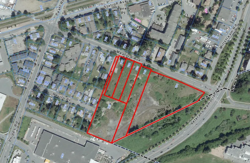
Table 2: Surrounding Land Uses
| Direction | Zoning | Use |
|---|---|---|
| North | R1 (One-Family Residential) RM2 (Attached Housing) MU1A (Mixed Use Residential Commercial A) C3 (District Commercial) CS1 (Service Commercial) |
Residential Multi-Family Residential Multi-Family Residential Residential Residential |
| East | A1 (Rural 1) – City of Colwood | Vacant |
| South | C3 (District Commercial) | Commercial |
| West | R1 (One-Family Residential) | Residential |
COMMENTS
OFFICIAL COMMUNITY PLAN
The Official Community Plan (OCP) Bylaw No. 1200 designates the subject property as ‘City Centre’, which is defined by the following text:
- A major regional growth and employment centre that supports a wide range of high-density housing, including affordable and rental housing, in conjunction with commercial, office, institutional and light industrial uses;
- A place with the highest degree of inter-city connection through a regional transportation network and transportation hubs;
- A place where a wide range of public squares, parks, and open spaces are integrated throughout;
- A place of community gathering and celebration where civic uses and public buildings are key landmarks; and
- A place of interactive and animated streetscapes where public art and public space are employed to celebrate local cultural and natural history.
DEVELOPMENT PERMIT AREAS
There is one small portion of the site located within an environmental Development Permit (DP) area, that being the Riparian DP area. This area is located in the southeastern corner and is due to the proximity to Colwood Creek. A DP would need to be issued in this regard and is anticipated to correspond with the DP that would be needed on Colwood’s side of the property.
Additionally, as these properties are located within the ‘City Centre’ OCP designation, DP’s for Form and Character would be needed for all proposed buildings. The design of future buildings as well as an overall site plan would need to be submitted and comply with Langford’s Design Guidelines as well as the City Centre objectives.
A Development Permit would also be needed prior to land alteration as the City Centre DP area is designated as a commercial revitalization area. Currently there are no exemptions for land alterations with this DP area, except for removal of hazardous trees. Council may wish to consider providing an exemption to allow land alterations within a commercial revitalization area if the land is not located within an environmental development permit area.
DEVELOPMENT PROPOSAL
Details of any future build out or specific uses are not fully known, but are anticipated to include multi-family residential and an automobile dealership. The proposed new zone will allow for a variety of uses that include retail/commercial (automobile dealership, hotel, office, restaurant), business/technology (electronic sales and manufacturing, educational and recreational uses), and/or multi-family residential.
Details of how any proposed building would look will need to be worked through at the Development Permit stage. Council may wish to require the details of where buildings will be located and what uses they contain be worked out through an overall master plan DP to ensure it complies with City bylaws, policies, and objectives.
Table 3: Proposed Data
| Item | Permitted by R1 (Current Zoning) | Permitted by MUE4 (Proposed Zoning) |
|---|---|---|
| Permitted Uses | • One-Family Dwelling • Group Daycare |
• Townhomes • Apartments • Hotels • Restaurants • Retail Stores • Automotive Dealership • Recreational Facility • Offices |
| Density | 550m² lots | 6.0 FAR |
| Height | 9m (30 ft) | N/A |
| Site Coverage | 35% | N/A |
| Front Yard Setback | 7.5m (25 ft) | 5.5m (townhouse) 2.0m (commercial/multi-family) |
| Interior Side Yard Setback | 1.5m (5 ft) | 1.5m (townhouse) 4.0m (commercial next to residential) |
| Exterior Side Yard Setback | 4.5m (15 Ft) | 3.5m (townhouse) 2.0m (commercial/multi-family) |
| Rear Yard Setback | 7.5m (25 ft) | 5.5m (townhouse) 2.0m (commercial/multi-family) |
| Parking Requirement | 2 per dwelling | As per Part 4 of Bylaw 300 |
NEW MUE4 ZONE SPECIFICATIONS
A proposed new MUE4 Zone has been drafted, based on the MUE1 (Mixed-Use Employment) zone, which applies to the large parcel of land located southwest of the Leigh Road interchange. The main difference between these two zones would be the allowable density and amenity contributions as outlined in the proposed zone specifications attached as Appendix C.
This new MUE4 zone would allow for a range of uses and a density ratio that has the potential to create a mixed-use area that includes commercial/retail and residential. However, given the range of potential uses but no final commitments with respect to a site plan at this point, Council may wish to establish some baseline requirements to ensure the future build out is in a shape and form that compliments the City Centre. Council may wish to require the following standards for this site:
- That any residential building proposed along Meaford Avenue provide commercial/retail space within all of the ground floor units that face Meaford Avenue, with a minimum 370m² (4,000 ft²) of commercial space provided.
- That the northeast corner at Meaford Avenue and Veterans Memorial Parkway be the location for a building that has a minimum footprint of 1,000m² (10,800 ft²) and be at least 2-storeys in height at the corner, or at least be designed to resemble 2-storeys at the corner.
- That the minimum floor area ratio for the overall site be 2.0.
- That a master plan for the entire site be accepted by the Director of Planning prior to issuance of a Development Permit for Form and Character.
- That plazas / open space areas are planned for within the master plan.
- That a vehicle connection through the site that allows the general public to pass be provided from Revilo Place to Meaford Avenue.
FRONTAGE IMPROVEMENTS
The subject properties front Meaford Avenue, the end of Revilo Place, and a small portion of Veterans Memorial Parkway.
Veterans Memorial Parkway (VMP)
Road improvements along VMP are considered completed, but any additional requirements would come from the Ministry of Transportation and largely coordinated with the City of Colwood, as the majority of VMP associated with this development is within Colwood.Revilo Place
Revilo Place will connect to the site, and possibly for emergency access purposes only. If this extension through the site is dedicated as municipal road, it would need to be built to Bylaw 1000 standards to the satisfaction of the Director of Engineering.Meaford Place
Road dedication and improvements will be required along Meaford Avenue. The improvements would be designed to the R1 cross-section of Bylaw 1000 and include the following:- Red brick paver sidewalk;
- Road edge parking;
- Landscaped boulevard;
- Street lights.
SEWERS
Sewer mains exist within Revilo Place and Meaford Avenue. Any improvements or modifications needed to the sewer mains within the municipal road right-of-way will be constructed by West Shore Environmental Services at the applicant’s expense.
DRAINAGE AND STORMWATER MANAGEMENT
As the site develops over time, an engineer of record would need to submit a detailed stormwater management plan, to the satisfaction of the Director of Engineering outlining how stormwater will be managed onsite. However, as a condition of rezoning, Council may wish to request the applicant to provide a preliminary technical memo in this regard from a qualified engineer, to the satisfaction of the Director of Engineering.
VEHICLE ACCESS AND ROAD NETWORK
The applicant is requesting that the City rezone these properties before a detailed development plan or a road network plan is finalized. Council may wish to request the applicant provide a Transportation Impact Assessment (TIA) prior to 2nd reading. From the TIA, any recommended road network improvements necessary to accommodate the increased density would then be secured in a covenant and implemented prior to issuance of a building permit. Any density proposed in the future beyond what this TIA assessed, would require that an additional TIA Terms of Reference be developed in concert with the Ministry of Transportation and Infrastructure as per their request.
Details of any internal roads onsite also need to be presented prior to issuance of a master plan development permit in order to plan appropriately for future traffic flows through the site and to/from access points. This would be secured in the same covenant as noted above.
AMENITY CONTRIBUTIONS
Given the size of this site and the potential density that could be achieved, it’s possible that amenity contributions generated by this development could be around $3,000,000. This is based on Council’s current policy and compared to the residential development that has recently completed on the north side of Meaford Avenue (728 Meaford Avenue), which has a FAR of 4.0. However, without knowing how this site will develop, Council may wish to require some amenity contributions as a lump sum upfront, similar to how amenity contributions were requested on the Belmont Market site.
It is anticipated that this site would not be entirely residential, but would also include an automobile dealership. There would also be land used for roads, plazas/open space and parking throughout the site, so an upfront lump sum General Amenity Contribution of $1,000,000 may be reasonable. Additional General Amenity Contributions would be collected on a per unit basis once the lump sum contribution rate equals the number of units created. The Affordable Housing Amenity Fund would be collected on a per unit basis throughout the build out. The lump sum contribution could be collected over four minimum payments of $250,000 every 6-months beginning in December of 2020 if commencement of any residential building has not started yet.
FINANCIAL IMPLICATIONS
Rezoning the subject property to permit a higher density of development will increase the assessed value of lands and increase municipal revenue due to the number of units created. As the developer must complete all frontage improvements, the direct capital costs to the City associated with this development will be negligible. A summary of Amenity Contributions and Development Cost Charges that the developer will be expected to pay, is outlined in Tables 4 and 5 below.
FINANCIAL CONTRIBUTIONS
Council’s Amenity Contribution Policy
The amenity contributions similar to Council’s current Affordable Housing, Park and Amenity Contribution Policy are summarized in Table 4 below.
Table 4 – Amenity Contributions
| Amenity Item | Contribution Rate |
|---|---|
| General Amenity Reserve Fund | $1,000,000 in four lump payments of $250,000 + $712.50 per unit after 515 units have been created |
| Affordable Housing Reserve Fund | $750* per unit * The applicant is entitled to a 50% or 75% reduction depending on the use and height, for units above the 4th storey. |
Table 5 – Development Cost Charges
| Development Cost Charge | Per unit / area contribution | Total |
|---|---|---|
| Roads | $3,188 (multi-family) $55.78 (commercial m²) |
TBD |
| Park Improvement | $1,890 (multi-family) | TBD |
| Park Acquisition | $1,100 (multi-family) | TBD |
| Incremental Storage Improvement Fees | $331.65 (multi-family) $140/1000ft² (commercial) |
TBD |
| Integrated Survey Area | $35 per lot | TBD |
| Subtotal (DCCs paid to City of Langford) | TBD | |
| CRD Water | $2,557 (multi-family) $10.74/m² (commercial) |
TBD |
| School Site Acquisition | $600 (multi-family) | TBD |
| TOTAL (estimate) DCCs | TBD |
OPTIONS
Option 1
That Council:
- Proceed with consideration of 1st reading of Bylaw No. 1893 to amend the zoning designation of the properties located at 721, 749, 755, 759, 767, and 769 Meaford Avenue from R1 (One-Family Residential) to a new MUE4 (Mixed-Use Employment 4) Zone subject to the following terms and conditions:
a) That the applicant provides, as a bonus for increased density, the following contribution prior to issuance of a building permit:
i. $250,000 by December 1, 2020, or prior to the issuance of the first Residential Building Permit, whichever is first; and
ii. $250,000 by June 1, 2021, or 180 days from the issuance of the first Residential Building Permit, whichever is first; and
iii. $250,000 by December 1, 2021, or 365 days from the issuance of the first Residential Building Permit, whichever is first; and
iv. $250,000 by June 1, 2022, or 545 days from the issuance of the first Residential Building Permit, whichever is first; and
v. $712.50 per unit after 515 units have been created towards the General Amenity Reserve Fund; and
vi. $10.75 per m² ($1.00 per ft²) of gross floor area per commercial and/or business development towards the General Amenity Reserve Fund; and
vii. $750* per unit towards the Affordable Housing Reserve Fund.
*subject to reductions depending on the use and height in accordance with the Affordable Housing and Amenity Contribution Policy.
b) That the applicant provides, prior to 2nd reading, the following:
i. A technical memo from a qualified engineer that verifies storm water can be adequately managed on-site for the proposed development, to the satisfaction of the Director of Engineering; and
ii. A Transportation Impact Assessment, to the satisfaction of the Director of Engineering and the Ministry of Transportation and Infrastructure.
c) That the applicant provides, prior to Bylaw Adoption, a Section 219 covenant, registered in priority of all other charges on title, that agrees to the following:
i. That an overall mixed-use master plan implementing the objectives of the City Centre OCP designation be provided to the satisfaction of the Director of Planning prior to issuance of a Form and Character Development Permit for the site; and
ii. That plazas / open space areas are included in the master plan; and
iii. That any residential building proposed along Meaford Avenue provides a minimum 370m² (4,000 ft²) of commercial/retail space within all the ground floor units facing Meaford Avenue; and
iv. That the northeast corner at Meaford Avenue and Veterans Memorial Parkway be the location of a building that has a minimum footprint of 1,000m² (10,800ft²) and be 2-storeys in height at the corner, or at least be designed to resemble 2-storeys at the corner; and
v. That the minimum floor area ratio for the overall site be 2.0; and
vi. That a no-build covenant be registered on all the subject properties, which can be released upon the consolidation of the subject properties and when at least 4.0m (13 ft) along the frontage of 755, 759, and 767 Meaford Avenue is dedicated as road; and
vii. That all road dedication of new roads and/or widening of existing roads is provided prior to issuance of a building permit or subdivision approval, whichever is first, to the satisfaction of the Director of Engineering and Approving Officer; and
viii. That an access route through the site be provided from Revilo Place to Meaford Avenue, which could be for emergency access purposes only; and
ix. That the recommendations from the Traffic Impact Assessment be completed prior to issuance of a building permit or subdivision approval, whichever is first, to the satisfaction of the Director of Engineering and the Ministry of Transportation and Infrastructure; and
x. That an additional Traffic Impact Assessment be completed and works implemented for any additional density proposed beyond what the original TIA assessed; and
xi. That all frontage improvements to Bylaw 1000 standards are provided prior to issuance of a building permit or subdivision approval, whichever is first, to the satisfaction of the Director of Engineering;
xii. That a storm water management plan be provided prior to issuance of a building permit or subdivision approval, whichever is first, and implemented as per Bylaw 1000, all to the satisfaction of the Director of Engineering; and
xiii. That a construction parking and traffic management plan be provide prior to the issuance of a building permit, to the satisfaction of the Director of Engineering; and
xiv. That the required residential parking stalls for this development are allocated for the use by individuals in each unit, as required by Bylaw 300 and designed accordingly, and that parking stalls are not rented out individually.
OR Option 2
- Take no action at this time with respect to Bylaw No. 1893.
Submitted by
Robert Dykstra, MCIP, RPP Land Development Planner - Email Approved
Concurrence
- Matthew Baldwin, MCIP, RPP, Director of Planning - Email Approved
- Adriana Proton, Manager of Legislative Services - Email Approved
- Chris Aubrey, Fire Chief - Email Approved
- Lorne Fletcher, Manager of Community Safety and Municipal Enforcement - Email Approved
- Cory Manton, Manager of Parks and Recreation - Email Approved
- Michelle Mahovlich, P.Eng, P.Geo, Director of Engineering - Email Approved
- Leah Stohmann, MCIP, RPP, Deputy Director of Planning - Email Approved
- Michael Dillabaugh, CPA, CA, Director of Finance - Email Approved
- Darren Kiedyk, Chief Administrative Officer - Email Approved
:rd
Appendix A
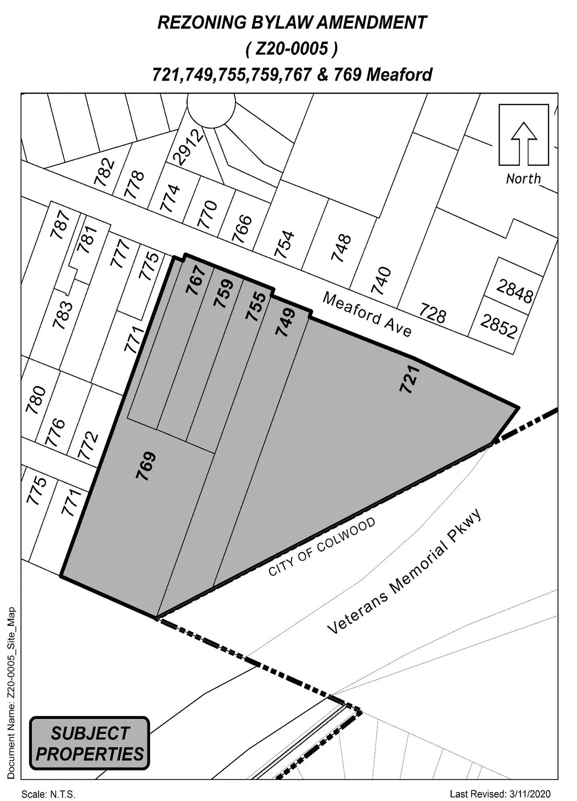
SUBJECT PROPERTY
Appendix B
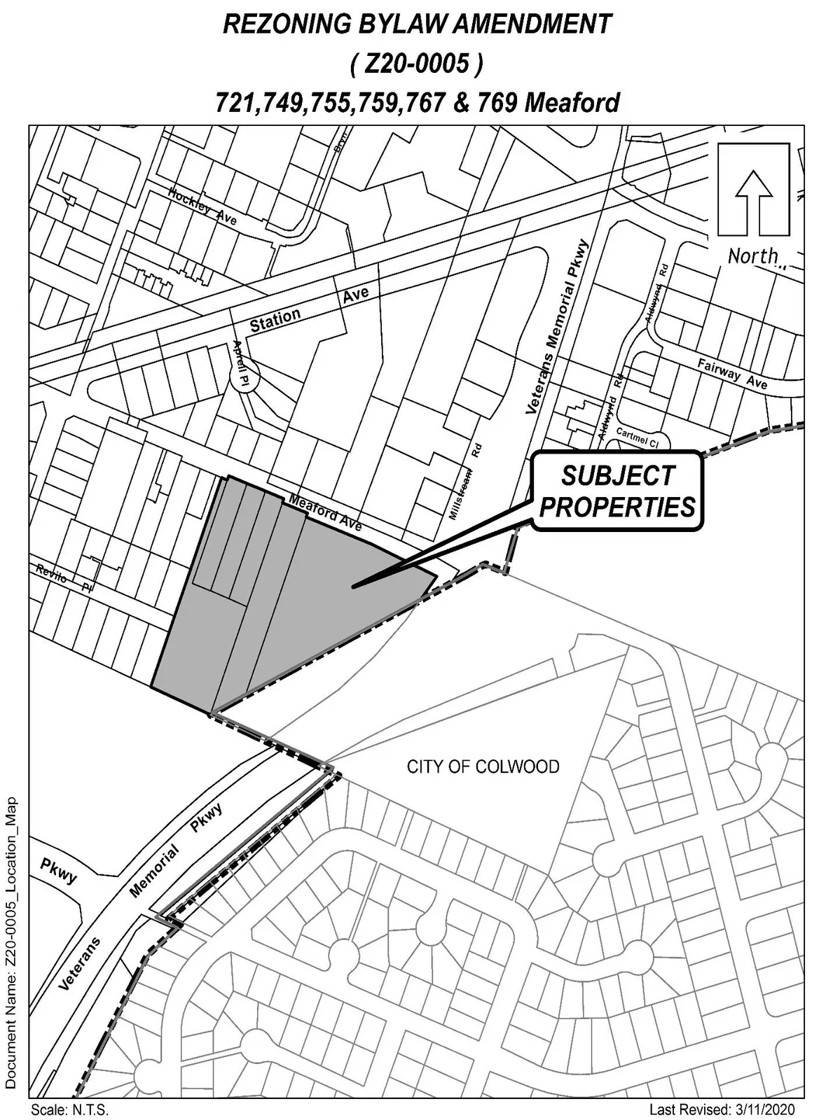
LOCATION MAP