DocumentsStaff ReportJul 15, 2019Pages 85–94
Staff Report / Bylaw 1854 - Application to amend lakefront lot subdivision regulations (2849 Lake End Rd)
Staff report (Bylaw 1854) proposing amendments to lakefront lot subdivision regulations of the R1 Zone for property at 2849 Lake End Rd, including analysis and recommended bylaw text.
Key facts
- Property: 2849 Lake End Rd
- Bylaw proposed: 1854 (amend R1 lakefront subdivision regulations)
- Report includes rationale, proposed text changes and referral/consultation notes
Staff Report
to
Planning, Zoning and Affordable Housing Committee
Date:
June 24, 2019
Department:
Planning
Application No.:
Z19-0007
Subject:
Bylaw 1854 - Application to amend the lakefront lot subdivision regulations of the R1 Zone for the property at 2849 Lake End Rd
PURPOSE
Jesse Friest has applied to amend the text within the R1 Zoning regulations for the property located at 2849 Lake End Road to remove the requirement to exclude the SPEA from the calculation of minimum lot size calculations for lake-front lots and to allow for the subdivision of a 550 m2 lot immediately behind the lakefront lot, to allow for a two lot subdivision.
BACKGROUND
PREVIOUS APPLICATIONS
No previous applications are associated with this development.
Table 1: Site Data
| Item | Details |
|---|---|
| Applicant | Jesse Friest |
| Owner | Jesse Friest |
| Civic Address | 2849 Lake End Road |
| Legal Description | LOT A, SECTION 1, GOLDSTREAM DISTRICT, PLAN EPP83755, PID 006-326-498 |
| Size of Property | 0.214 ha (2,190 m2) |
| DP Areas | Riparian, 200-year Floodplain |
| Zoning Designation | One-family residential (R1) |
| OCP Designation | Hillside or shoreline |
SITE AND SURROUNDING AREA
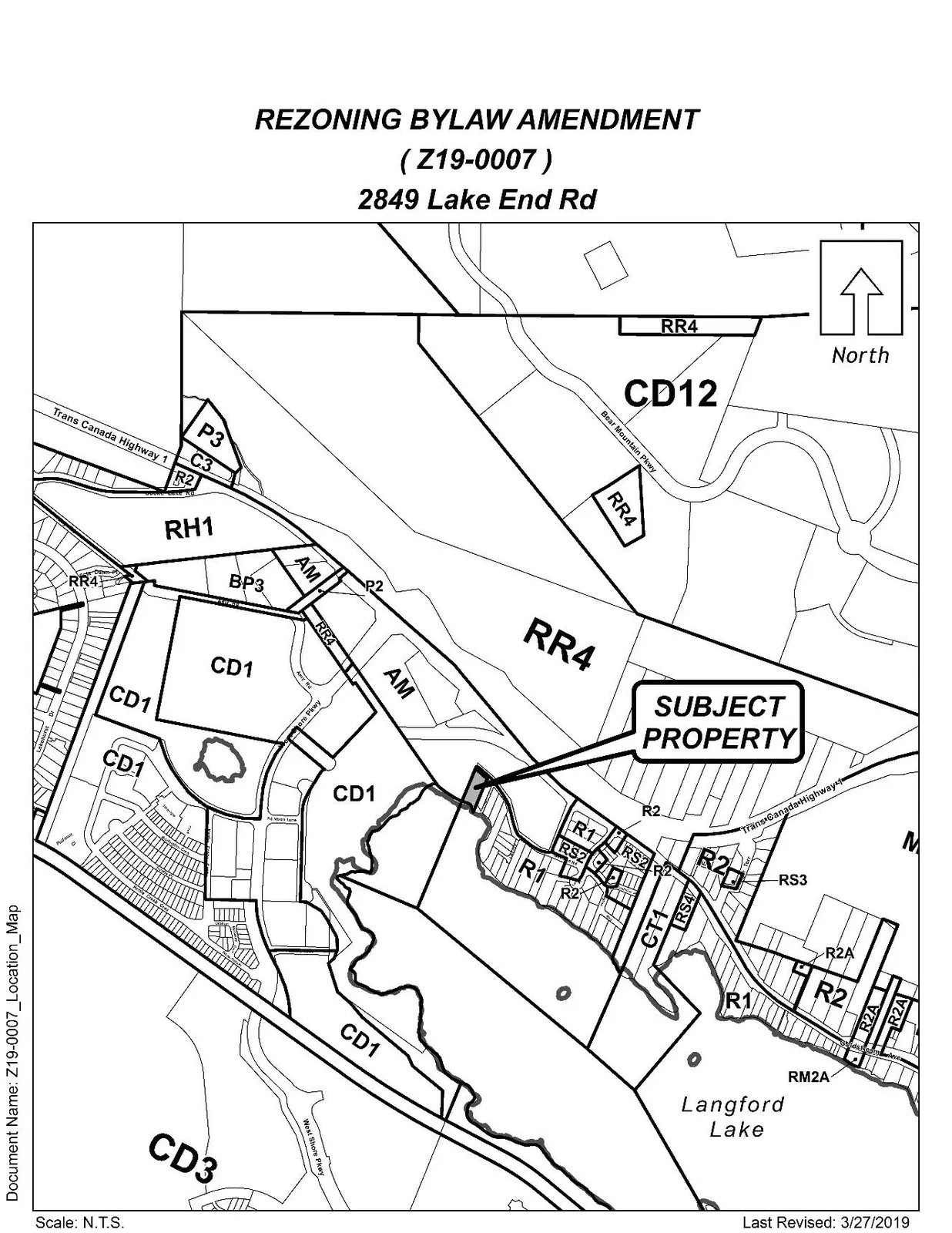
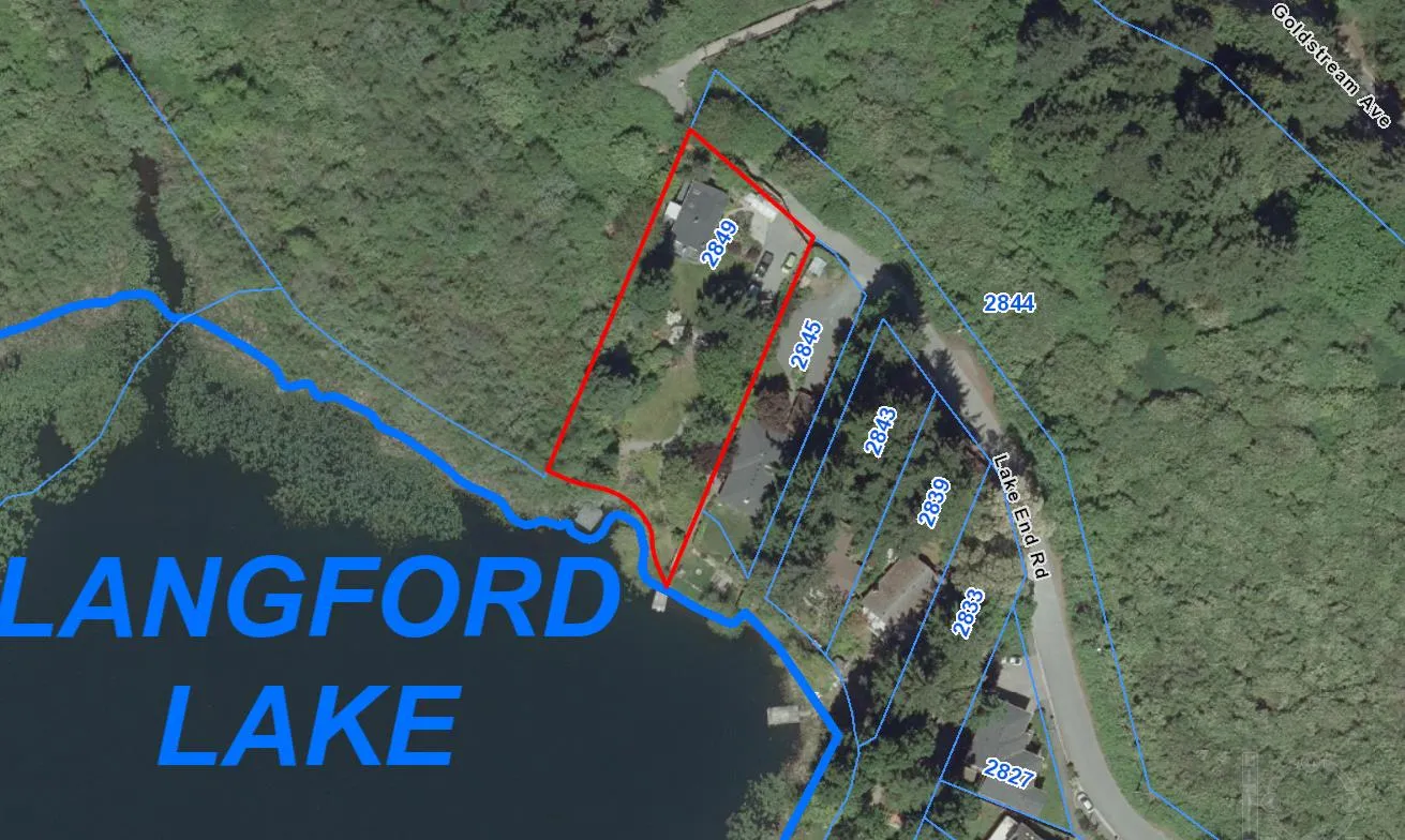
The site is bound by Langford Lake to the south (approximately 37 m of shoreline) and a connected wetland to the west. The surrounding area is comprised of predominately single-family dwellings in the R1 and R2 residential zones. Currently, the site is occupied with a single-family dwelling located on the northwest of the property and a gazebo and dock at the south end of the property. The site grade slopes gently from the north-east down towards the lake (south-west). A large extent of the waterfront consists of manicured lawn, and the area between the existing house and the wetland to the west consists of a mix of native and non-native species.
Table 2: Surrounding Land Uses
| Zoning | Use |
|---|---|
| North | AM (Amenity Zone) — Undeveloped/Parkland/Wetland |
| East | R1 (One Family Residential) — Single Family |
| South | - — Langford Lake |
| West | AM (Amenity Zone) — Undeveloped/Parkland/Wetland |
COMMENTS
OFFICIAL COMMUNITY PLAN
Hillside or Shoreline
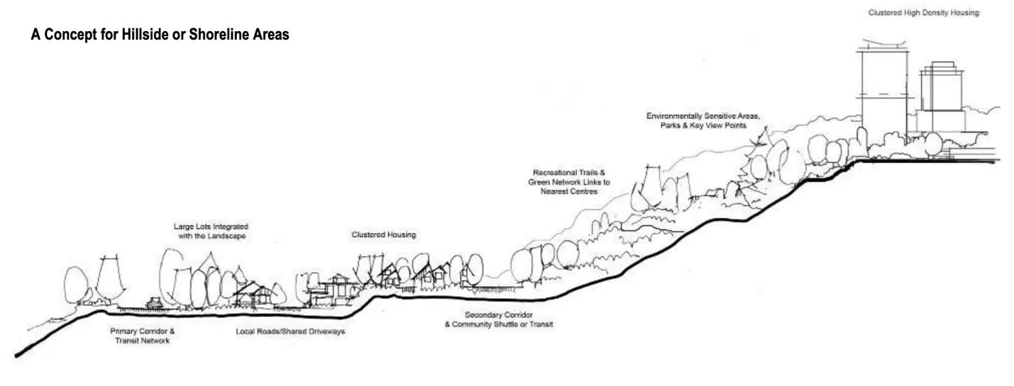
Predominantly existing low intensity settled areas throughout community with a high percentage of open space and undeveloped areas located on a hillside or near the shoreline.
The subject property is currently designated as Hillside or Shoreline, which supports predominately low intensity settled areas with a high percentage of open space and undeveloped areas. Amending the text within the R1 Zone would align with current policy that supports a range of clustered low, medium and high-density housing choices.
DEVELOPMENT PERMIT AREAS
Portions of the property are located in the Riparian, and 200 Year Flood Plain Development Permit Areas. Development Permits will be required prior to any alteration of land, construction of new buildings or structures, or subdivision of the subject site. The applicant has submitted a Riparian Areas Report (RAR) which identifies a 15 m Streamside Protection and Enhancement Area (SPEA) from the high water mark of Langford Lake. The SPEA will be protected as a non-disturbance area though the Development Permit process.
DEVELOPMENT PROPOSAL
The applicant is proposing to amend the R1 zone to amend two provisions that apply to the subdivision of existing lakefront lots: the requirement to exclude the SPEA when calculating the minimum lot size on lake-front properties as well as to allow a 550 m2 lot to be created behind the new lakefront lot. These changes would allow the 2,190m2 parcel to be subdivided into two lots.
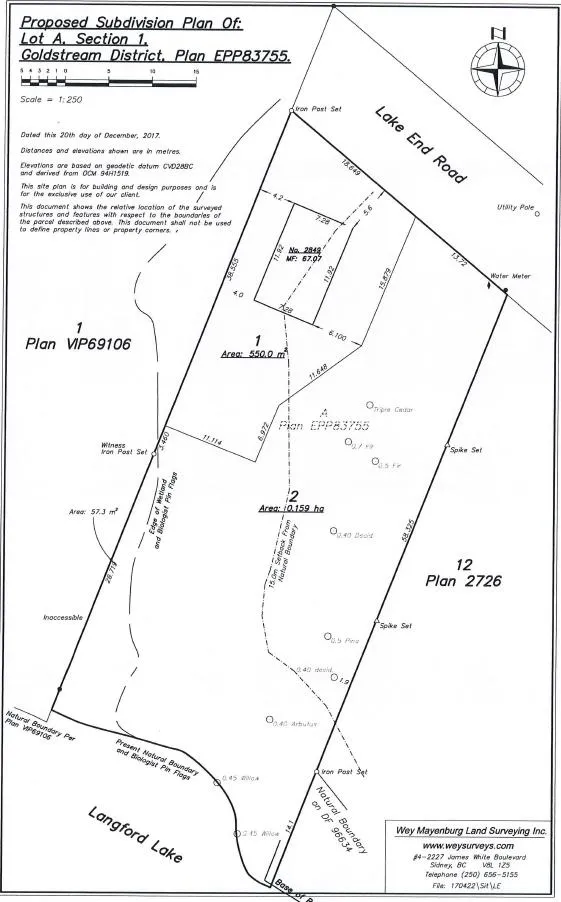
The applicant is proposing to create one lake-front lot of approximately 1,590 m2 (including the SPEA) and a remainder lot off Lake End Road with an area of 550 m2. It is noted for Council’s reference that the 550 m2 lot would contain a lawfully non-conforming single-family dwelling as a portion of the house is located within the SPEA non-disturbance area.
The implementation of these proposed changes will not alter the requirement to protect the overall function of the SPEA, as no change to the development permit requirements is proposed, nor will it alter the character of the lakeshore communities. Excluding the SPEA from the minimum lot size calculation typically involves an increase of 5-10% to the lot size of the new lakefront lot, which is fairly negligible from a visual perspective when the lot is already either 1,500 m2 (0.37 ac) or 950 m2 (0.23 ac) in area. Furthermore, removing the requirement to include the SPEA in the calculation of lot area will provide land owners a greater degree of certainty around their ability to subdivide, without having to engage a professional biologist.
As noted, the applicant has also requested a bylaw amendment to allow the creation of a typical 550m2 lot behind the new lakefront lot. Currently, as per Zoning Bylaw 300, the subdivision requirements applied to all existing lakefront lots specify a minimum lot size of 1,500 m2 (plus the SPEA), or 950 m2 if the SPEA is dedicated to the City as parkland. In order words, each lot within the subdivision must meet the 1,500 m2 or 950 m2 minimum lot size, not just the new lakefront lot(s).
Under the current regulations, where the lots within a proposed subdivision meet these lot size requirements and the new lot that is no longer lakefront is adequately sized, it may be further subdivided after the fact. For example, if a subject property is at least 3,000 m2, it could be subdivided initially into two 1,500+ m2 lots to satisfy the minimum lot size requirements, one adjoining the lake and one behind. The rear 1,500+ m2 lot not adjoining the lake is then no longer subject to the lakefront regulations, and could be further subdivided into two or more 550 m2 lots. The applicant is requesting that he be granted the ability to create a 550m2 lot directly behind the lakefront lot in a situation where the property is not currently subdividable, as it is not adequately sized to create two 1,500+ m2 lots.
If Council feel that these amendments are appropriate, they may also wish to consider applying these changes to all lakefront properties in the R1 and R2 Zones. Staff have received several similar requests and inquiries from other lakefront property owners that would like to pursue one or both of these changes for their own properties.
It is noted that the applicant has also requested a variance to reduce the lot width of the lakefront lot from the required 18m to 13.72m. As can be seen on the proposed plan, attached the this report as Appendix A, the lot configuration has been designed to create a 550 m2 lot around the existing house, and to create a workable building envelope outside of the SPEA on the lakefront lot. The lakefront lot does open up to a full width of 30+m, however is 13.72 where the lot width must be calculated as per the Zoning Bylaw. The Director of Planning has the ability to issue a variance to the minimum lot width within the Environmental Development Permit, where the variance is being sought to preserve an environmentally valuable feature or minimum impacts on an environmentally sensitive area.
DRAINAGE AND STORMWATER MANAGEMENT
This site is located within a Drainage Concern DP area in an area of the City where stormwater infiltration or detention may occur, as per Bylaw 1000, depending on what a qualified professional recommends. The applicant will be required to submit a Stormwater Management Plan prior to Public Hearing.
SEWERS
The City’s sewer system exists along Lake End Road. The applicant will be required to connect each lot to the municipal sewer and be responsible for the costs associated with connecting at the time of subdivision.
FRONTAGE IMPROVEMENTS
The Engineering Department has noted that a Streetlight fronting the development may be required as a condition of subdivision approval.
FINANCIAL CONTRIBUTIONS
Council may wish to provide direction with regards to how the Amenity Contribution Policy should be applied, or not, as part of this application. If Council opts to globally change the lakefront subdivision requirements in the R1 and R2 Zone, they may view this as an omnibus amendment that would not trigger amenity contributions, or alternatively, they may wish to insert a density bonus provision into the R1 and R2 Zones that would require amenity contributions for all new 550 m2 lots created by the amended regulations. Conversely, if Council wishes to proceed with this amendment for the subject property only, they may wish to apply the amenity contribution policy to the one new lot that would otherwise not be possible due to lot area.
In addition, as the applicant will be responsible for connecting the new lot to municipal sewer and water, and complete frontage improvements at the discretion of the Director of Engineering, the direct capital costs to the municipality associated with this development will be negligible. Development Cost Charges (DCCs) will apply at the time of subdivision.
A summary of the amenity contributions required pursuant to Council’s Amenity Contribution Policy and DCCs pursuant to the DCC Bylaw No. 26 are listed in Tables 3 - 4 below:
Table 3 – Development Cost Charges
| Development Cost Charge | Per new lot created |
|---|---|
| Roads | $6,056 |
| Park Improvement | $1,890 |
| Park Acquisition | $1,100 |
| Incremental Storage Improvement Fees | $495 |
| Integrated Survey Area | $35 |
| Subtotal (DCCs paid to City of Langford) | $9,576 |
| CRD Water | $2,922 |
| School Site Acquisition | $698 |
| TOTAL (estimate) DCCs | $13,196 |
Table 4: Amenity Contributions
| Amenity Item | Per new lot created |
|---|---|
| Affordable Housing Reserve Fund | $1,000 |
| General Amenity Reserve Fund | $6,000 |
| TOTAL POLICY CONTRIBUTIONS1 | $7,000 |
OPTIONS
That the Planning, Zoning and Affordable Housing Committee recommend that Council:
Option 1
- Direct staff to prepare a bylaw to amend the text within the R1 and R2 Zones such that the SPEA may be included in the minimum lot size calculation of lakefront lots and to allow 550 m2 lots to be created within a lakefront parent parcel, behind lots that directly adjoin the lake or a lakefront park;
Subject to the following:
(a) That the applicant provides, prior to Public Hearing, a technical memo from an engineer that verifies storm water can be adequately managed on-site for the proposed developments, to the satisfaction of the Director of Engineering
And Either (b) or (c):
(b) Direct staff not to insert a requirement for amenity contributions for additional lots that may be created by these amendments;
OR
(c) Direct staff to insert into the R1 and R2 Zones, as a bonus for increased density, a requirement for the following contributions to be provided per new lot created by these changes prior to subdivision approval:
i. $6,000 towards the General Amenity Reserve Fund; and
ii. $1,000 towards the Affordable Housing Reserve Fund
OR Option 2
- Direct staff to prepare a bylaw to amend the text within the R1 Zone for the subject property at 2849 Lake End Road only such that the SPEA may be included in the minimum lot size calculation of lakefront lots and to allow 550 m2 lots to be created within a lakefront parent parcel, behind lots that directly adjoin the lake, or a lakefront park;
Subject to the following:
(a) That the applicant provides, prior to Public Hearing, a technical memo from an engineer that verifies storm water can be adequately managed on-site for the proposed developments, to the satisfaction of the Director of Engineering; and
(b) That the applicant provides, as a bonus for increased density, the following contributions prior to subdivision approval:
iii. $6,000 towards the General Amenity Reserve Fund; and
iv. $1,000 towards the Affordable Housing Reserve Fund
OR Option 3
- Take no action at this time with respect to Bylaw No. 1851.
Submitted by:
David Sametz, Land Development Planner
Concurrence:
- Matthew Baldwin, MCIP, RPP, Director of Planning
- Cory Manton, Manager of Parks and Recreation
- Michelle Mahovlich, P.Eng, P.Geo, Director of Engineering
- Leah Stohmann, MCIP, RPP, Deputy Director of Planning
- Michael Dillabaugh, CPA, CA, Director of Finance
- Braden Hutchins, Director of Corporate Services
- Darren Kiedyk, Chief Administrative Officer
:ds
Appendix A
Proposed Subdivision Plan
Appendix B
Subject Site Location
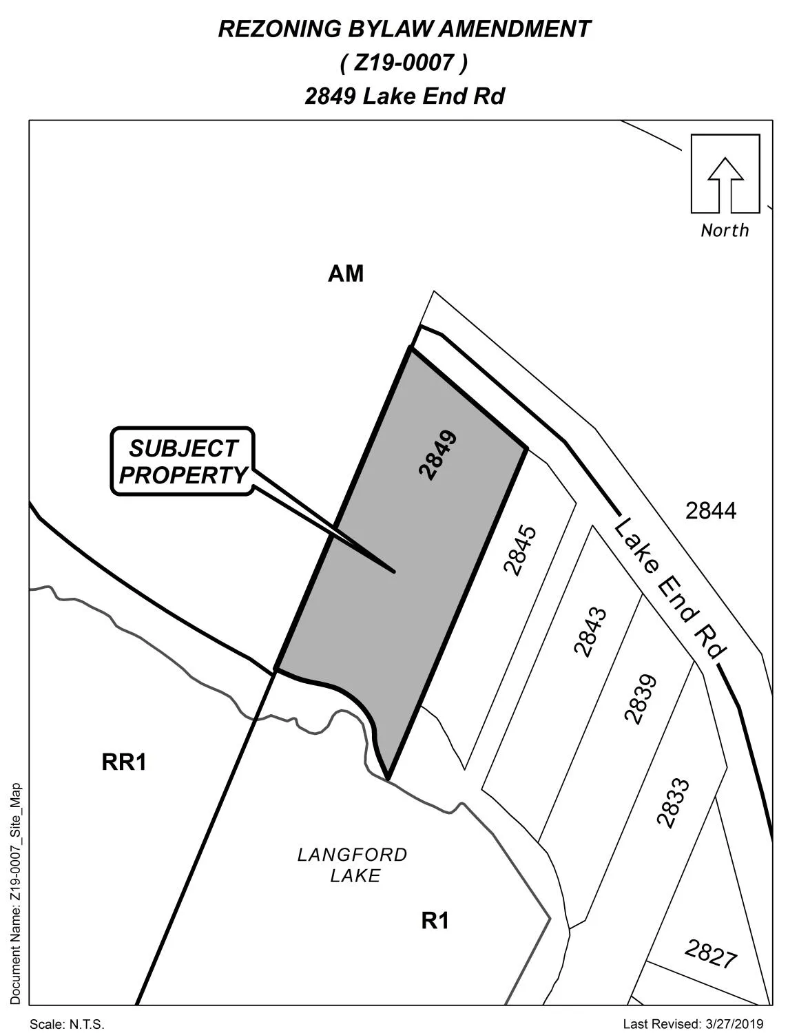
Appendix C
Subject Property Location