DocumentsStaff ReportJul 15, 2019Pages 57–62
Staff Report - ALR19-0001: Application to Exclude 3582 Kathy Lane from the Agricultural Land Reserve
Planning staff report (ALR19-0001) for an application by Tom Littler and Elizabeth Willis to exclude the western portion (approx. 1.9 ha) of 3582 Kathy Lane from the ALR to better use non-farmable land and protect adjacent farmable lands.
Key facts
- Applicant/Owner: Tom Littler
- Civic address: 3582 Kathy Lane
- Legal: Lot 1, Section 80, Metchosin District, Plan 7142
- Property size: 24,572.26 m² (6.07 acres)
- DP areas: Habitat & Biodiversity, Riparian Area, partial 200-year flood plain
Staff Report - ALR19-0001: Application to Exclude 3582 Kathy Lane from the Agricultural Land Reserve
Date
June 10, 2019
Department
Planning
Application No.
ALR19-0001
Subject
Application to Exclude 3582 Kathy Lane from the Agricultural Land Reserve
PURPOSE
Tom Littler and Elizabeth Willis have applied to exclude 3582 Kathy Lane from the Agricultural Land Reserve to make better use of the land that is not farm-able, and to encourage protection of green space on the subject property and viable farm land on adjoining properties.
BACKGROUND
Application
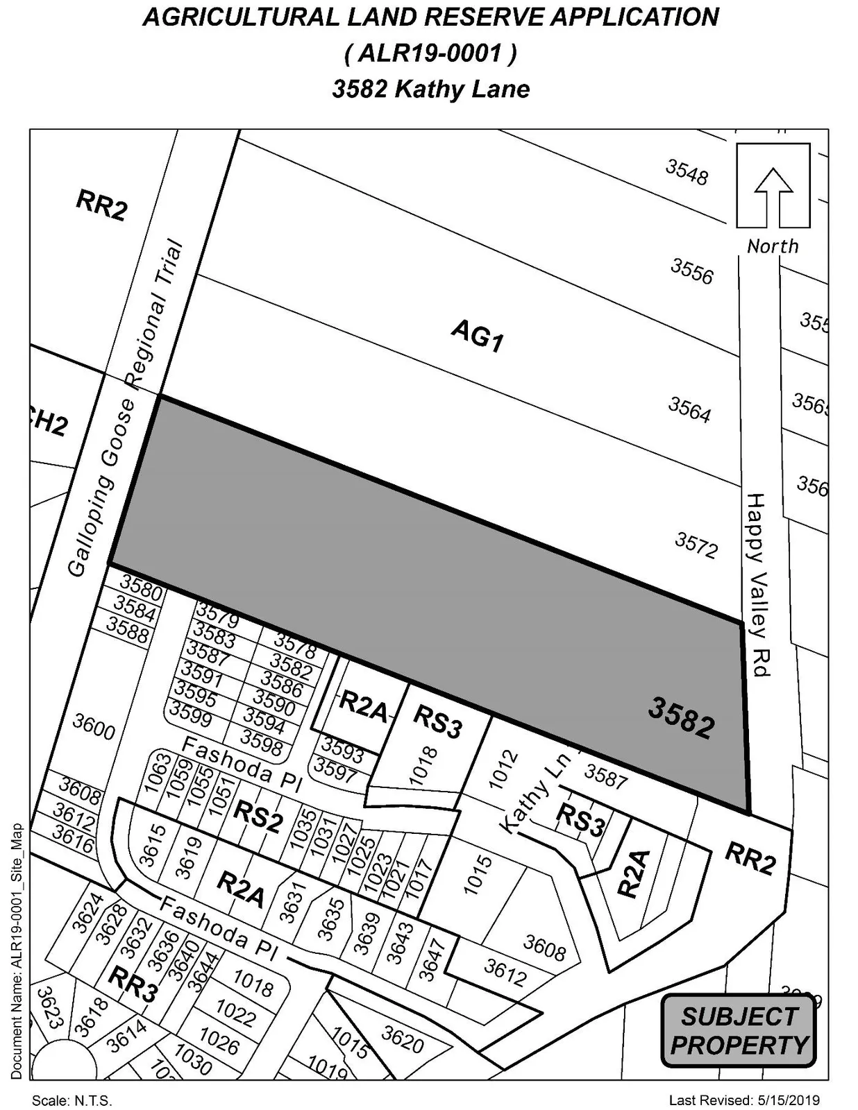
The applicant proposes to exclude the western 1.9 hectares of the 3582 Kathy Lane property from the ALR. There is no development proposal attached to the application, however, the intent is to make better use of the non-farmable land on the property.
Table 1: Site Data
| Item | Details |
|---|---|
| Applicant and Owner | Tom Littler |
| Civic Address | 3582 Kathy Lane |
| Legal Description | Lot 1, Section 80, Metchosin District, Plan 7142 |
| Size of Property | 24572.26 m2 (6.07 acres) (2.4 hectares) |
| DP Areas | Habitat and Biodiversity, Riparian Area, and partial 200 Year Flood Plain |
| Zoning Designation | Agriculture 1 (AG1) |
| OCP Designation | Agricultural |
Site and Surrounding Area
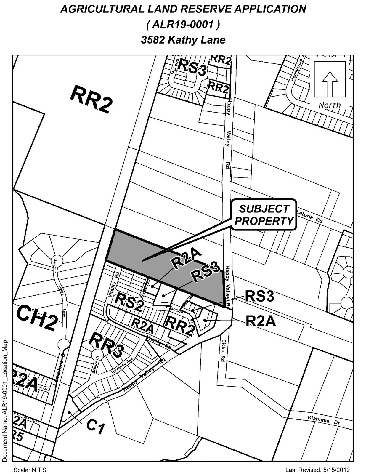
The existing site is currently not being used for agricultural purposes. The two properties to the North are owned by Mr. Littler and Ms. Willis, and are actively farmed. The subject property is located in South Langford along the Happy Valley corridor, neighbouring agricultural land to the north and a subdivision development to the south. The neighbourhood is comprised of a variety of land uses and functions as identified in the table below.
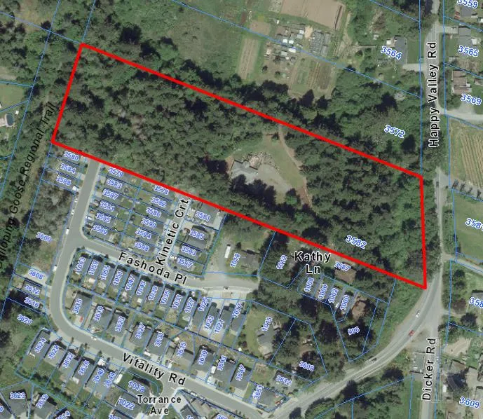
Table 2: Surrounding Land Uses
| Direction | Lot PID | Size (Acre) | Zoning | Use |
|---|---|---|---|---|
| North | 005738253 | 4.07 | AG1 | Farm Land |
| East | 000356921 | 4.74 | AG1 | Farm Land |
| East | 003981576 | 2.07 | AG1 | Farm Land |
| South | 027951901 | 0.07 | RS2 | Residential |
| South | 027951898 | 0.08 | RS2 | Residential |
| South | 027951782 | 0.08 | RS2 | Residential |
| South | 027951774 | 0.14 | R2A | Residential |
| South | 004891074 | 0.47 | RS3 | Residential |
| South | 005188474 | 0.31 | RR2 | Residential |
| South | 005188512 | 0.32 | RR2 | Residential |
| West | 024731897 | 0.66 | CH2 | Residential |
| West | N/A | 11.08 | RR2 | Forested Area |
COMMENTS
Official Community Plan
This subject property is designated as Agricultural Land in the Official Community Plan (OCP). The OCP provides direction and purpose with regards to ALR lands within Langford:
- Objective 11.3 “Ensure development in or around farmlands does not preclude long term viability.
- Policy 11.3.1 – Develop a edge planning policy for properties adjacent to ALR properties or acquire farmland as a means to ensure new development will not jeopardize the long term use of the land for agricultural purposes.
- Policy 11.3.3 – As it relates to exclusion applications of farmlands from the ALR, the City will support exclusions provided there is considerable benefit that can be provided such as farmland dedications for community trust and/or upgrades to farming/farmland infrastructure as part of exclusions.
In relation to the aforementioned objectives and policies of the OCP, the proposal to have the western 1.9 hectares of the subject property removed from the ALR has the potential to be an example or exercise in policy for ALR exclusions moving forward. If Council supports this application, they may wish to require the applicant to provide and implement an edge plan for those portions of the excluded area adjoining ALR land.
Development Permit Areas
The subject property is within the following Development Permit Areas:
- Habitat and Biodiversity Areas;
- Riparian Areas; and
- Partial 200 Year Flood Plain issues.
A development permit will be required prior to any land alteration.
Agricultural Suitability
The applicant contracted an Agrologist to survey and report on the classification of the land to be excluded. The Agrologist determined that it would only be necessary to survey 1.25 of the 1.9 hectares as the remaining .65 hectares contained the homestead and was of no significant agricultural value. The Agrologist’s report concluded that 1.05 hectares consisted of class 6 or “poor” land that is not improvable and the remaining .20 hectares as class 3 or “good” land that is improvable to class 2 or even class 1. However, the class 3 land is not continuous and therefore limits the type of crops that can be grown, it was determined that the class 3 land would be best for native crops and grazing.
An Agricultural Suitability Review was conducted by the City of Langford in 2007 in order to identify land suitable for ALR retention. The subject property is located in lands identified for ALR retention along with the neighbouring properties to the north. The subject property was categorized as capability 2 of agricultural suitability, this type of area would benefit from minor improvements to maximize agricultural productivity. Under the capability 2 level, the report stated that the larger parcels have enough undisturbed land to develop some intensive crop production in high value crops such as Raspberries, Strawberries and vegetables but drainage infrastructure and improvements would be critical.
Neighbourhood Consultation
As per the requirements of application, the applicants have taken the following steps to provide adequate consultation and information dispersal:
- News paper advertisements (Jan 22, 2019 and Jan 29, 2019);
- Proof of servicing notice; and
- On-site signage of application.
Financial Contributions
Council’s Affordable Housing, Park and Amenity Contribution Policy
In 2015, Council passed a resolution to require a contribution of $13.45/m2 of land excluded from the ALR as a bonus for increased density at the time of rezoning. However, as part of the process for the two properties that have come forward for rezoning since that time, a contribution of $6.72/m2 was required.
OPTIONS
That the Planning, Zoning and Affordable Housing Committee recommend that Council:
Option 1
- Not support the application to exclude the property at 3582 Kathy lane and to not authorize the application proceed to the ALC.
Or
Option 2
- Support the application to exclude the property at 3582 Kathy lane and direct staff to forward the application to the ALC subject to the applicant preparing and implementing an edge plan.
Submitted by
Wolfgang Schoenefuhs, Planning Technician
Concurrence
- Matthew Baldwin, MCIP, RPP, Director of Planning
- Adriana Proton, Manager of Legislative Services
- Michelle Mahovlich, P.Eng, P.Geo, Director of Engineering
- Leah Stohmann, MCIP, RPP, Deputy Director of Planning
- Michael Dillabaugh, CPA, CA, Director of Finance
- Braden Hutchins, Director of Corporate Services
- Darren Kiedyk, Chief Administrative Officer
:ws
Appendix A
Appendix B
Document Images
(2)