DocumentsStaff ReportMay 15, 2017Pages 20–32
Staff Report to Planning, Zoning and Affordable Housing Committee – Z16-0017 (2762 & 2768 Claude Rd)
Comprehensive staff report analyzing the rezoning application for 2762 & 2768 Claude Road from R2 to a new MU2 zone to permit a 10-storey (later modified to 11-storey) apartment building; includes site analysis, design guidance, parking, traffic, DCCs and amenity contributions and recommended conditions.
Key facts
- Location: 2762 and 2768 Claude Road; combined lot area: 1,823 m²
- Original proposal: ten (10) storey building ~117 units; applicant later requested 11 storeys and ~100 units
- Parking: requirement 122; proposal 117 onsite with 4 on-street (variance), applicant offered $5,000 for one deficient stall
- Amenity contributions (rental-reduced amounts): $381.25 per unit (General Amenity) and $152.50 per unit (Affordable Housing); total policy contributions example $62,448.75 (for 120 units in table)
- Development Cost Charges estimate total: $1,031,896.71 (including CRD Water $1,493.63/unit)
Staff Report to Planning, Zoning and Affordable Housing Committee – Z16-0017 (2762 & 2768 Claude Rd)
Date
February 27, 2017
Department
Planning
Application No.
Z16-0017
Subject
Application to amend the zoning designation of the property at 2762 and 2768 Claude Road from R2 (One-Family Residential) to a new MU2 (Mixed-Use Residential Commercial Zone) to allow for the construction of a (10) storey residential building consisting of approximately 117 dwelling units
PURPOSE
Matt McKay of DB Services of Victoria Inc. has applied on behalf of Matthew and Margaret McKay and Danny Lahnsteiner to rezone the properties at 2762 and 2768 Claude Road from R1 (One-Family Residential) to MU2 (Mixed-Use Residential Commercial Zone) to allow for the construction of a ten (10) storey residential building consisting of approximately 117 residential dwelling units.
BACKGROUND
There are no previous development applications for the subject properties.
APPLICATION DATA
Table 1: Site Data
| Item | Details |
|---|---|
| Applicant | Matt McKay |
| Owner | Matthew, Margaret Mckay and Danny Lahnsteiner |
| Location | 2762 and 2768 Claude Road |
| Legal | THAT PART OF LOT 6, SECTION 72, ESQUIMALT DISTRICT, PLAN 3544, LYING TO THE SOUTH OF A STRAIGHT BOUNDARY JOINING THE POINTS OF BISECTION OF THE NORTH WESTERLY AND SOUTH EASTERLY BOUNDARIES OF SAID LOT, PID 006-227-449 (2768 Claude Road) and THAT PART OF LOT 6 SECTION 72 ESQUIMALT DISTRICT PLAN 3544 LYING TO THE NORTH OF A STRAIGHT BOUNDARY JOINING THE POINTS OF BISECTION OF THE NORTH WESTERLY AND SOUTH EASTERLY BOUNDARIES OF SAID LOT, PID 006-227-431, 2762 Claude Road) |
| Size of Property | 1,823 m² (both properties combined) |
| DP Areas | Multi-Family |
| Zoning | Existing: R1 (One-Family Residential) Proposed: MU2 (Mixed-Use Residential Commercial Zone) |
| OCP Designation | City Centre |
SITE AND SURROUNDING AREA
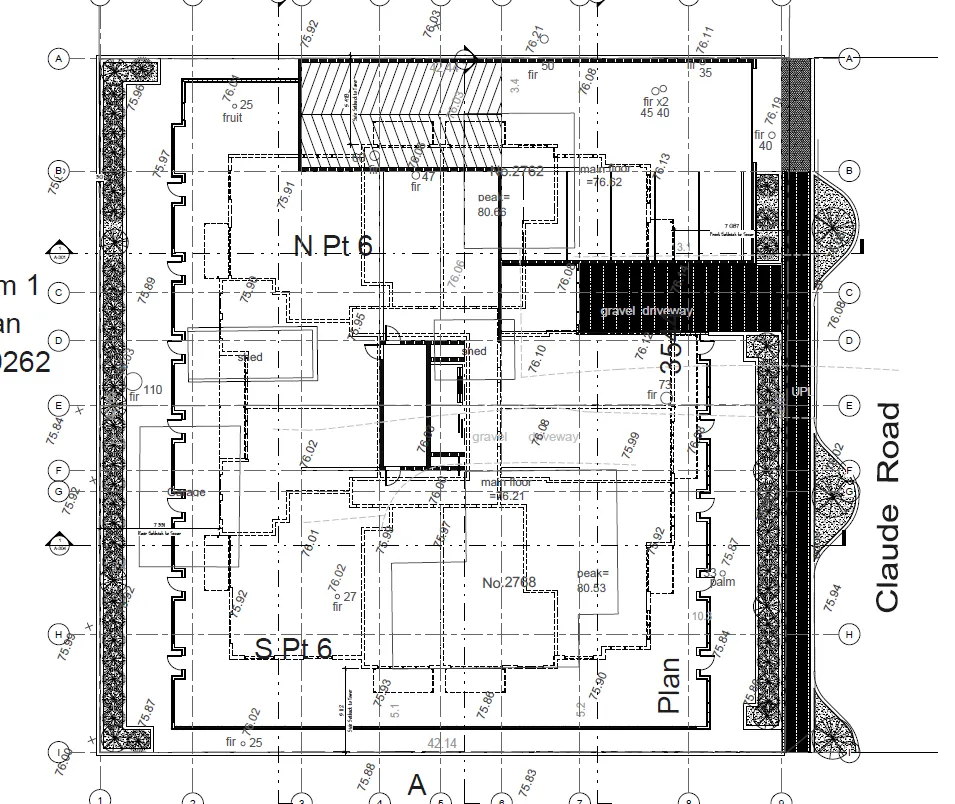
The subject properties are flat and both properties are occupied by one-family dwellings. Both properties have a sparse mix of coniferous and deciduous trees which are proposed to be removed.
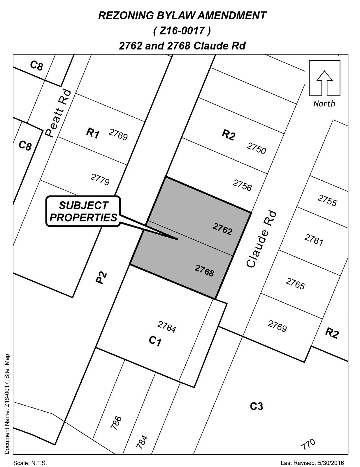
Directly north of the subject site is a one family dwelling. To the south is the Saint Vincent Du Paul second hand store. Immediately to the west is a strip of land owned by the church and currently used for parking. To the west is a one family dwelling.
Table 2: Surrounding Land Uses
| Direction | Zoning | Use |
|---|---|---|
| North | R2 (One and Two-Family Residential) | Residential |
| East | R2 (One and Two-Family Residential) | Parking lot adjacent to Danbrook Park |
| South | C1 (Neighbourhood Commercial) | Commercial/Retail |
| West | P2 (Community Institutional) | Church |
COUNCIL POLICY
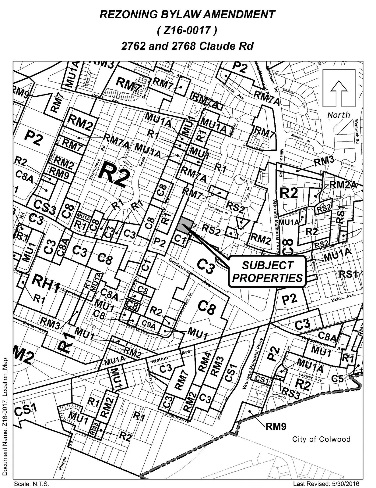
The Official Community Plan (OCP) Bylaw No. 1200 designates the subject property as City Centre, as defined by the following text:
- A major regional growth centre that support a wide range of high density housing, including affordable and rental housing;
- A major employment area for institutional, office, commercial and light industrial;
- Major civic uses and public buildings are key landmarks;
- A major place of community gathering and celebration;
- A wide range of public squares, parks and open spaces are integrated throughout;
- The City’s major entertainment and/or cultural precinct;
- Inter-city and/or inter-regional transit hub connects residents.
Policy 5.1.3 Relate all neighbourhood development and infill to the nearest centre through direct and/or improved connections, scale and character.
Policy 5.4.1 Encourage street-orientation of buildings along all roads and corridors where topographical conditions allow.
Policy 5.5.2 Ensure residential densities and the location of dense development increases viability and frequency of transit service.
COMPLIANCE WITH THE OFFICIAL COMMUNITY PLAN
The proposal is consistent with the OCP’s “City Centre” designation as it fits in with the growth management and land use strategy in an existing developed area. This designation supports a mix of residential and commercial uses, including medium and high density housing.
DEVELOPMENT PERMIT AREAS
The subject property is designated within the Multi-Family Development Permit Area, and therefore subject to a form and character development permit. The subject property is not designated as an environmentally sensitive or hazardous development permit area.
COMMENTS
DEVELOPMENT PROPOSAL
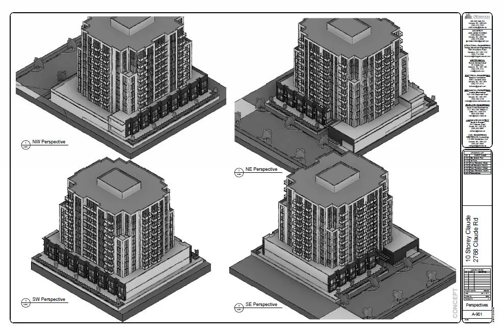
The applicant wishes to rezone the subject property to a new MU2 (Mixed-Use Residential Commercial) zone to allow for the construction of a ten (10) storey apartment building with approximately 117 dwelling units and underground parking.
Council has received applications for high density/high-rise type buildings in the past (3 examples below), but due to market conditions, these buildings never started construction.
- Example No. 1 – 770 Goldstream Ave (Z-07-33) Langford Centre (Formerly, Westbrook Mall). In 2007, Council gave second and third readings to amend the zoning of the property to include two, 10 storey residential buildings.
- Example No. 2 – 2885 Jacklin Road (DVP-06-11) (immediately adjacent to the Rail Corridor) In 2006, when 2885 Jacklin Road was a vacant lot, Council approved a Development Variance Permit to allow for the development of a 15 storey residential building.
- Example No. 3 – 2771 Jacklin Road (Z-09-14) (across from Ruth King Elementary School) In 2009, a proposal for a seniors care apartment building consisted of a 14 and 9 storey building (connected at the lower levels). Council eventually chose to have the applicant redesign to a smaller structure of 6 - 8 stories due to concerns from the adjacent owners. This application did not proceed.
BUILDING AND SITE DESIGN
Prior to issuance of a building permit, Multi-Family developments are subject to a form and character development permit. The orientation, scale, form, materials, and architectural character of the building is controlled by the development permit to ensure good aesthetics and to achieve a relative compatibility with existing neighbourhoods.
While the Bear Mountain and Westhills Developments have anticipated tall buildings and therefore have design guidelines for buildings over five storeys in height (several shown italicized below), the City does not yet have design guidelines for tall buildings in the rest of Langford.
- Using extensive stepping and terracing of the elevations and altering the massing of structures so that the heights of various portions of the building are staggered between higher and lower storeys;
- Avoiding any massing or single material that rises vertically more than four storeys, unless the façade is punctuated by articulation, terraces, balconies with towers, pergolas or dormers;
- Where possible, buildings over five storeys in height should have some setback from the boundaries of the lot to allow for ground level landscaped areas and semi-private outdoor space
TYPICAL GUIDING PRINCIPLES FOR TALL BUILDINGS
Shown below, are typical guiding principles for the massing and design of tall buildings. They are often structured to focus on the three main sections of the building:
The Base
The base is often considered to be the bottom 2 - 4 stories and should be sited to be compatible with the adjacent streetscapes. This is to ensure that the base does not overwhelm the pedestrian environment and ensures that access to sunlight and sky views are maintained for pedestrians and neighbouring properties.The Middle (tower)
The middle section of the building is often setback further from the base, as the massing, visual dominance and shading is more substantial than typical low rise buildings. This staggered setback maintains access to sunlight and skyviews for the neighbouring properties.The Tower Top
The tower portion of the building can be seen as the top floor or two or the top 15-20% of the building height. The tower is often designed primarily through reduced massing and greater articulation and secondarily through material to create an integrated and appropriate conclusion to the tall building form.
The general multi-family design guidelines will apply for the proposal, but given the City has does not have design guidelines for tall buildings outside of the Bear Mountain and Westhills Developments, Council may wish to Direct the Director of Planning to apply the relevant Bear Mountain and Westhills design guidelines for the subject development. Furthermore, Council may also wish to direct staff to amend the multi-family design guidelines to include a new section for tall buildings based on the above noted principles.
Table 3: Proposal Data
| Item | MU2 Zone (The City’s current highest density zone) | MU2 Zone (proposal/suggested setbacks) |
|---|---|---|
| Density (max floor space ratio) | 4.0 | 4.72 (Council may wish to consider amending the MU2 zone to allow for an FSR up to 5 as we expect to see taller buildings in the future that will need a larger FSR) |
| Height | 10 storeys | 10 storeys |
| Lot Coverage | 90% or up to 100% if a rooftop patio is provided | 62% |
| Front Yard Setback | 1.2 m (4ft) | 0m to the stairs and landscape wall, foundation structure (Variance Required) 4m to the base 7m for the tower |
| Interior Side Yard Setback (North Side) | 0 m (0ft) when in the City Centre OCP Designation | 0m for the base 9.7m for the tower |
| Interior Side Yard Setback (South Side) | 0 m (0ft) when in the City Centre OCP Designation | 1.2m for the base 5.1m for tower |
| Rear Yard Setback | 0 m (0ft) when in the City Centre OCP Designation | 4.5m for the base 7.3m for tower |
| Parking Requirement | 122 | 117 onsite with 4 on street (Variance Required) |
VARIANCE REQUESTS (SETBACKS AND PARKING)
The applicant is proposing a 0m setback to the front yard setback to accommodate retaining walls for landscaping. This area also forms part of the elevated structure for the underground parking. Except for the first two floors which are proposed to be setback approximately 4m, the tower portion of the building is proposed to be setback approximately 7m. Council has delegated the authority to the Director of Planning to approve variances for reductions to front, side, and rear lot lines as part of a Development Permit where such variances are an improvement to the relationship and orientation between a building and an access route or public road, reduce any impact of development on surrounding lands, and where a reduction in a setback does not have significant impacts on adjacent properties. As such, Council may wish to direct the Director of Planning to issue the variance to the front yard setback in the Development Permit.
PARKING
Zoning Bylaw No. 300 requires all parking (designated and visitor) to be located on-site. The applicant is proposing to provide one designated stall per dwelling unit on site (117 stalls) and locate 4 of the 5 required visitor parking stalls in the City boulevard. As such, the applicant is proposing to vary the visitor parking component as the visitor stalls are required on site. In the past, Council has supported minor parking variances and charged $5000 when the applicant cannot provide a compensatory stall on City boulevard. In this case, the applicant is willing to pay $5,000 for the 1 deficient stall and provide 4 compensatory visitor parking on the City boulevard (on the west side of Claude Road). Council may wish to consider directing the Director of Planning to issue the parking variance in the Development Permit subject to the applicant paying $5,000 prior to issuance of a Building Permit.
TRAFFIC AND PUBLIC SAFETY
Council may wish to have the applicant provide a construction management parking plan, prior to any onsite works and/or clearing, to the satisfaction of the Director of Engineering, and have this condition secured in a Section 219 Covenant registered on title prior to bylaw adoption. This should address any concerns around employee parking during construction.
TRAFFIC STUDY
Given the added volume of traffic to the Claude Road area, Council may wish to secure in a Section 219 covenant that the applicant pay for and install the works to restrict southbound left turns on Claude Road turning left onto Goldstream Avenue prior to issuance of an Occupancy Permit.
FRONTAGE IMPROVEMENTS
Council may wish to require as a condition of rezoning that full frontage improvements to the standards of Bylaw No. 1000 be provided and that this be secured in a S.219 Covenant to be provided at the time of Building Permit.
ROAD DEDICATION
The applicant will be required to dedicate land for road to line up with the road width at 2784 Claude Road. As such, Council may wish to require that the amount road dedication be demonstrated prior to Public Hearing (to ensure the project is feasible) and can be provided to the City as a condition of rezoning and be dedicated to the City prior to bylaw adoption.
SEWERS
The City’s Sewer system has been installed along Claude Road. The applicant will be required to connect all units to the municipal sewer system and the applicant will be responsible for the costs of installing the sewers and any extension should it be required.
FUS REQUIREMENTS
The applicant will be required to provide the required FUS calculations prior to building permit, however, applicants are encouraged to provide calculations earlier in the process in case any substantial upgrades are required.
DRAINAGE AND STORMWATER MANAGEMENT
Prior to issuance of a building permit, the applicant must demonstrate that storm water can be managed on-site. To ensure future owners are apprised of the maintenance obligations, Council may wish to require a Section 219 Covenant be registered on title prior to the request for Occupancy Permit as a condition of rezoning.
NEIGHBOURHOOD CONSULTATION
The developer will be commencing door-to-door canvassing to inform the neighbours in the immediate vicinity about the development proposal. The Planning Department has not yet received any feedback directly from the neighbours.
FINANCIAL CONTRIBUTIONS
FINANCIAL IMPLICATIONS
Rezoning the property to permit a multi-family residential development will contribute more to municipal revenue than redevelopment under the present zoning. Considering that the applicant will be required to provide full frontage improvements the proposal should not represent an increased cost burden to the City. A summary of the amenity contributions as per Council’s Amenity Contribution, Parks and Amenity Contribution Policy and Development Cost Charges for this development are as follows:
Table 4 – Amenity Contributions per Council Policy*
| Amenity Item | Per unit contribution (120 units) | Total |
|---|---|---|
| General Amenity Reserve Fund | $381.25 per unit | $44,606.25 |
| Affordable Housing Reserve Fund | $152.50 per unit | $17,842.50 |
| TOTAL POLICY CONTRIBUTIONS | $533.75 per unit | $62,448.75 |
*These numbers include the 75% reduction in Amenity Fees (for rental housing) in accordance with Council’s Amenity Policy.
Table 5 – Development Cost Charges (based on 120 units)
| Development Cost Charge | Per residential unit | Total |
|---|---|---|
| Roads | $3,917 | $458,289 |
| Storm Drainage | n/a | |
| Park Improvement | $1,890 | $221,130 |
| Park Acquisition | $1,100 | $128,700 |
| Subtotal (DCCs paid to City of Langford) | $808,119 | |
| CRD Water | $1,493.63 | $174,754.71 |
| School Site Acquisition | $419 | $49,023 |
| TOTAL (estimate) DCCs | $1,031,896.71 |
*The applicant is also eligible for a 30% reduction it the total DCC’s (excluding CRD Water) as per Council’s DCC Bylaw.
OPTIONS
Option 1
That the Planning, Zoning and Affordable Housing Committee recommend that Council:
Direct staff to prepare a bylaw to amend the zoning designation of the property located at 2768 and 2762 Claude Rd from R1 (One-Family Residential) to MU2 (Mixed-Use Residential Commercial) subject to the following terms and conditions:
a. That the following contributions are included in the bylaw as an amenity for increased density, to be payable at the time of building permit:
i. $1,525 per unit towards the General Amenity Reserve Fund; and
ii. $610 per unit towards the Affordable Housing Reserve Fund.b. Notwithstanding 1. a, if the project is secured as rental housing, the following contributions are included in the bylaw as an amenity for increased density, to be payable at the time of building permit:
i. $381.25 per unit towards the General Amenity Reserve Fund; and
ii. $152.50 per unit towards the Affordable Housing Reserve Fund.c. That the applicant provide the following items prior to Public Hearing:
i. A road dedication plan;
d. That the applicant provide the road dedication to the City prior to bylaw adoption.
e. That the applicant register a Section 219 covenant, prior to bylaw adoption, that includes the following:
i. The owner pay for and construct all works to restrict left turn movements southbound on Claude Road to Goldstream Avenue prior to issuance of Occupancy Permit;
ii. The owner provide a traffic and public safety plan and construction parking management plan, prior to any onsite works and/or clearing, to the satisfaction of the Director of Engineering;
iii. The applicant shall construct frontage improvements, works and services to the standards of Subdivision and Development Servicing Bylaw No. 1000 and to the satisfaction of the Director of Engineering; and
iv. The owner will register on title a Section 219 covenant for stormwater maintenance prior to the request for Occupancy Permit as a condition of rezoning.Direct the Director of Planning to apply the Bear Mountain and Westhills design guidelines for tall buildings to the subject development.
Direct staff to amend the Multi-Family Design Guidelines to include design guidelines for tall buildings.
Direct staff to amend the MU2 zone to increase the Floor Space Ration from 4 to 5.
Direct the Director of Planning to issue the variance to reduce the front yard setback from 1.2m to 0m in the time of Development Permit, for a portion of the building and generally in accordance with the plans attached.
Direct the Director of Planning to issue the parking variance in the Development Permit subject to the applicant paying the City $5,000 for the one deficient stall prior to issuance of a building permit.
OR Option 2
- Reject this application for rezoning.
Respectfully submitted,
Submitted by:
Grant Liebscher, Planner II
Concurrence:
Matthew Baldwin, MCIP, RPP Director of Planning
Concurrence:
Mike Leskiw, Parks and Recreation Manager
Concurrence:
Michelle Mahovlich, P.Eng, P.Geo, Director of Engineering
Concurrence:
Brent Molnar, Manager of Land Development
Concurrence:
Steve Ternent, Director of Finance
Concurrence:
Jim Bowden, Chief Administrative Officer