DocumentsStaff ReportApr 18, 2017Pages 18–26
Staff Report (Planning) — Application to Rezone 592 Phelps Avenue (Z16-0010) to RS3 — June 13, 2016 (with Appendices)
Planning staff report recommending consideration of rezoning 592 Phelps Avenue (Z16-0010) from R2 to RS3 to allow subdivision into five small lots; includes site data, DP considerations, frontage requirements and financial contributions (DCCs and amenity fees).
Key facts
- Applicant: Ron McNeil on behalf of Jarnail Sandu
- Civic address: 592 Phelps Avenue; property size: 1,578 m²
- Proposal: Rezoning to RS3 to permit 5 single-family lots (original proposal)
- Amenity contributions (per unit): General Amenity $3,960; Affordable Housing $660; total policy contributions $18,480 (for 4 units in some tables)
- Estimated DCCs total (example table): $63,640.36 (includes City DCCs and CRD water and school site acquisition) — specific table entries included
Staff Report to Planning, Zoning and Affordable Housing Committee
Date: June 13, 2016
Department: Planning
Application No.: Z16-0010
Subject: Application to Rezone 592 Phelps Avenue from R2 (One- and Two-Family Residential) to RS3 (Residential Small Lot 3) to allow a future subdivision of five new single-family residential lots.
PURPOSE
Ron McNeil has applied on behalf of Jarnail Sandu to rezone 592 Phelps Avenue from R2 (One- and Two Family Residential) to RS3 (Residential Small Lot 3) in order to permit the future subdivision of five new single-family residential lots.
BACKGROUND
PREVIOUS APPLICATIONS
- There are no previous planning applications on record for the subject property.
Table 1: Site Data
| Item | Details |
|---|---|
| Applicant | Ron McNeil |
| Owner | Jarnail Sandu |
| Civic Address | 592 Phelps Avenue |
| Legal Description | Lot 1, Section 1, Range 2 West, Highland District, Plan VIP55565 |
| Size of Property | 1,578m² (0.4 acres) |
| DP Areas | Riparian Areas |
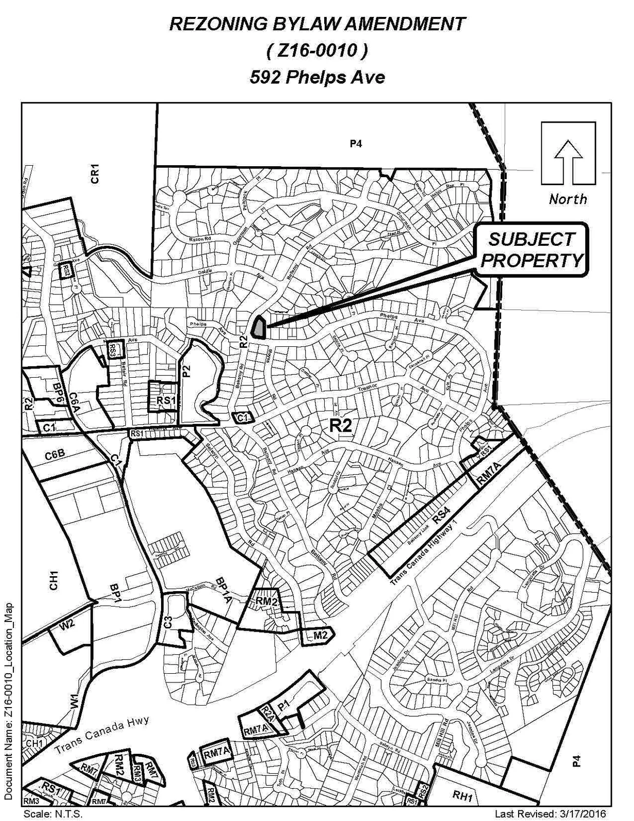
| Zoning | Existing: R2 (One- and Two-Family Residential) Proposed: RS3 (Residential Small Lot 3) |
| OCP Designation | Existing: Neighbourhood Proposed: Neighbourhood |
SITE AND SURROUNDING AREA
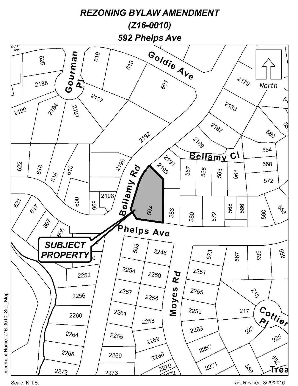
The subject property is primarily flat but rises towards the northern property boundary. A concrete retaining wall existing along the northern boundary, which is retaining the land immediately to the north. Along the northwest boundary, Bellamy Road is situated at a higher elevation then the property itself and is held up from the sloped ground at this corner.
The surrounding properties to the east, west, and south have single-detached family residential units located on them. Property to the north and one to the west have duplexes located on them.
Table 2: Surrounding Land Uses
| Direction | Zoning | Use |
|---|---|---|
| North | R2 (One- and Two-Family Residential) | Residential |
| East | R2 (One- and Two-Family Residential) | Residential |
| South | R2 (One- and Two-Family Residential) | Residential |
| West | R2 (One- and Two-Family Residential) | Residential |
COUNCIL POLICY
OFFICIAL COMMUNITY PLAN
The Official Community Plan (OCP) Bylaw No. 1200 designates the subject property as ‘Neighbourhood’, as defined by the following text:
Existing settled areas throughout the community predominantly located on the valley floor.
- Predominantly residential precinct that supports a range of low and medium density housing choices including secondary suites.
- This area allows for residential and mixed use commercial intensification of streets that connect centres and/or are serviced by transit.
- Schools, community facilities and other institutional uses are permitted throughout the area.
- Retail serving local residents is encouraged along transportation corridors.
- Home-based businesses, live-work housing is encouraged.
- Parks, open spaces and recreational facilities are integrated throughout the area.
- This area allows for Neighbourhood Centres to emerge in the form of medium density mixed-use nodes at key intersections.
- Transit stops are located where appropriate.
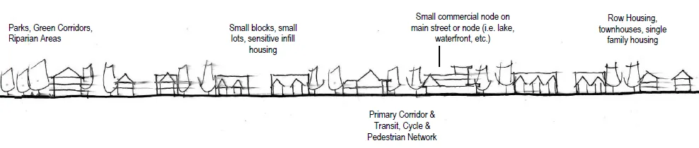
A Concept for Neighbourhood Areas
DEVELOPMENT PERMIT AREAS
This property is located within a Riparian Development Permit (DP) Area. The Riparian DP runs in an east-west direction, and properties to the east of this property already have a statutory right of way (SRW) registered on title due to the Riparian DP, which carries storm water to Millstream Creek. The applicant will need to obtain a DP in this regard, which will outline any requirements stemming from professional consultant’s review of the site.
The applicant will also need to submit a storm water management plan (SWMP) as part of the subdivision application, which will also highlight any need to secure a SRW on this property to allow for the flow of storm water. A registration of a SRW for storm water purposes may impact the location of property lines and building envelopes, but not to a point where lot yield is impacted.
COMMENTS
DEVELOPMENT PROPOSAL
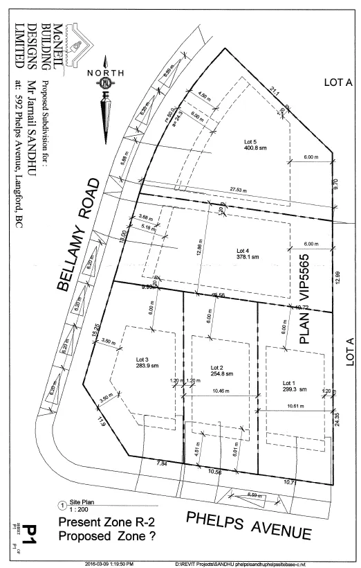
The applicant is requesting to rezone 592 Phelps Avenue from R2 (One- and Two Family Residential) to RS3 (Residential Small Lot 3) in order to permit the future subdivision of five new single-family residential lots.
The RS2 zone permits lots to be as small as 220m² (2,370 ft²), which is smaller than most lots in this neighbourhood. However, the smallest lot that the applicant is proposing is 255m² (836 ft²) and two of the lots are proposed to be 378m² and 400m² in size. Council may wish to consider permitting smaller lot sizes in this neighbourhood as the single detached homes appear more fitting with the majority of the surrounding homes. If the proposed smaller lots were to be declined, the current zone would permit this lot to be subdivided in two and each could potentially have a duplex built upon it. Even though there are a few duplexes in this neighbourhood, smaller lots with detached dwellings would appear more suitable.
Table 3: Proposal Data
| Item | Permitted by R2 (Current Zoning) | Permitted by RS2 (Proposed Zoning) |
|---|---|---|
| Permitted Use | - One- and Two-Family Dwellings - Secondary Suites in a One-Family Dwelling - Up to Four Boarders in a One-Family Dwelling - Accessory Buildings and Uses - Home Occupation - Group Day Care in Accordance with Section 3.26.02 |
- One-Family Dwelling - Up to One Boarder - Accessory Buildings and Uses - Home Occupation |
| Density (min. lot size) | 550m² (5,920 ft²) | 220m² (2,368 ft²) |
| Height | 9m (34 ft) | 8.5m (28 ft) |
| Site Coverage | 35% | 50% |
| Front Yard Setback | 6m (20 ft) | 3m (10 ft) except that it shall be 5.5m (18 ft) to a portion of a garage |
| Interior Side Yard Setback | 1.5m (5 ft) | 1.2m (4 ft) |
| Exterior Side Yard Setback | 4.5m (15 ft) | 3.5m (11.5 ft) |
| Rear Yard Setback | 6m (20 ft) | 5.5m (18 ft) |
| Parking Requirement | 2 spaces per principal dwelling unit + 1 parking space per secondary suite | 2 spaces per principle dwelling unit |
HOUSE DESIGN
Past practices for homes on corner lots has been to require the house to present a front style façade towards both streets, which includes front door entranceways, gables, and substantial window areas. Such requirements would be included within a Form and Character DP for the corner lot.
STORM WATER MANAGEMENT
It has been noted that a storm water drainage course exists to the east of this property, which has been secured with a registered statutory right of way. There is reason to believe that this drainage course affects this property (hence the Riparian DP area), and therefore Council may wish to ensure that any drainage course impacted this property is appropriately secured with a statutory right of way. This may require the proposed boundary lines and lots sizes to be amended slightly to accommodate the right of way, but would not eliminate any proposed lot.
GEOTECHNICAL
Along the northern boundary line is a concrete retaining wall that is approximately 1.8m (6 ft) in height, which was built as part of a previous development in 1993. Given the age of the wall and that seismic requirements have changes since 1993, the applicant will need to submit a geotechnical report that verifies this wall is geotechnical safe for the proposed lot next this wall, in accordance with today’s geotechnical standards.
SEWERS
The City’s sewer system existing along both frontage of the subject property. The applicant will be required to connect to municipal sewer and be responsible for the costs associated with connecting.
WATER REQUIREMENT
As we have seen few small lot developments north of the Trans-Canada Highway, the owner may need to calculate Fire Underwriters Survey requirements and build according to the necessary fire separation.
NUISANCES: WESTERN SPEEDWAY
Past practices for development proposals in some parts of north Langford has been for Council to require the applicate to register a restrictive covenant prior to final adoption that informs potential buyers that they would be located within 1.0km of Western Speedway, which may generate noise that some individuals could perceive as a nuisance. Council may wish to require this covenant as part of this development.
FRONTAGE IMPROVEMENTS
Full frontage improvements to the standard set out in the Subdivision and Development Servicing Bylaw is required as a condition of subdivision approval, and more specifically will include the following.
- Bellamy Road
- Bikes Lanes
- Curb and gutter
- Paving to centreline
- Street light(s)
- Street parking (1 space per 2 units)
- Boulevard grass and street trees with irrigation
- Phelps Avenue
- Paving to centreline
- Full frontage improvements, including a concrete sidewalk.
- Boulevard grass and street trees with irrigation
FINANCIAL CONTRIBUTIONS
Rezoning the subject property to permit higher densities of development may increase the assessed value of the property, and this may increase municipal revenue. As the applicant will connect the development to municipal sewers, and as the applicant will complete frontage improvements, the direct capital costs to the municipality associated with this development will be negligible. A summary of the amenity contributions required pursuant to Council’s Amenity Contribution Policy and Development Cost Changes required pursuant to DCC Bylaw No. 26 are listed in Tables 4 and 5 below.
Table 4 – Amenity Contributions per Council Policy
| Amenity Item | Per unit contribution | Total |
|---|---|---|
| General Amenity Reserve Fund | $3,960 | $15,840 |
| Affordable Housing Reserve Fund | $660 | $2,640 |
| TOTAL POLICY CONTRIBUTIONS | $18,480 |
Table 5 – Development Cost Charges
| Development Cost Charge | Per unit contribution | Total |
|---|---|---|
| Roads — Small Lot (≤300m²) | $4,423 | $8,846 |
| Roads — Single-Family (>300m²) | $6,949 | $27,796 |
| Park Improvement | $1,890 | $7,560 |
| Park Acquisition | $1,100 | $4,400 |
| Incremental Storage Improvement Fees | $371.25 | $1,485 |
| Integrated Survey Area | $35 | $140 |
| Subtotal (DCCs paid to City of Langford) | $50,227 | |
| CRD Water | $2,655.34 | $10,621.36 |
| School Site Acquisition | $698 | $2,792 |
| TOTAL (estimate) DCCs | $63,640.36 |
OPTIONS
Option 1
That the Planning, Zoning and Affordable Housing Committee recommend that Council:
- Direct staff to prepare a bylaw to amend the zoning designation of the property located at 592 Phelps Avenue from R2 (One- and Two-Family Residential) to RS3 (Residential Small Lot 3), subject to the following terms and conditions:
a) That the owner agrees to provide, as a bonus for increased density, the following contributions per new lot created, prior to subdivision approval: i. $3,960 towards the General Amenity Reserve Fund; ii. $660 towards the Affordable Housing Reserve Fund;
b) That the applicant provides, prior to Bylaw Adoption, a Section 219 covenant, registered in priority of all other charges on title, that agrees to the following: i. That an advisory note be written to provide future owners with the understanding and that Western Speedway is located within a kilometer and may generate a noise nuisance; ii. That full frontage improvements be completed as per the Subdivision and Development Servicing Bylaw No. 1000 as a condition of subdivision approval, to the satisfaction of the Director of Engineering; and iii. That all required measures recommended by the Stormwater Management Plan, which may include the registration of a statutory right of way, shall be implemented by the owner as a condition of Subdivision approval, to the satisfaction of the Director of Engineering.
OR Option 2
- Reject this application for rezoning.
Submitted by
Robert Dykstra, MCIP, RPP
Land Development Planner
Concurrence
- Matthew Baldwin, MCIP, RPP — Director of Planning
- Mike Leskiw — Parks and Recreation Manager
- Michelle Mahovlich, P.Eng, P.Geo — Director of Engineering
- Brent Molnar — Manager of Land Development
- Steve Ternent — Director of Finance
- Jim Bowden — Chief Administrative Officer
:rd
Appendix A
Appendix B
Appendix C