DocumentsBylawMay 16, 2016Pages 53–70
BYLAW NO. 1622 - Langford Zoning Bylaw, Amendment No. 453 (CD12 - South Skirt Mountain)
Comprehensive Development zone (CD12) amendment bylaw to modify regulations and mapping for the South Skirt Mountain lands (Bear Mountain area); includes replacement of Section 6.101 and associated schedules and maps.
Key facts
- Bylaw No.: 1622
- Subject: CD12 (South Skirt Mountain) zone amendments and Schedule replacements
- Addresses/lands referenced include multiple Bear Mountain Pkwy parcels (2131, 2181, 2160, 2200, 2250, 2251, 2300, 2350) and Echo Valley Dr and Savory Rd parcels
- Council to give First Reading (as per PZAH resolution)
BYLAW NO. 1622
A BYLAW TO AMEND BYLAW NO. 300, “LANGFORD ZONING BYLAW, 1999"
The Council of the City of Langford, in open meeting assembled, hereby enacts as follows:
A. Langford Zoning Bylaw No. 300, 1999 is amended as follows:
By replacing Section 6.101 with the text set out in Schedule A;
By replacing Appendix “S” with the text set out in Schedule B;
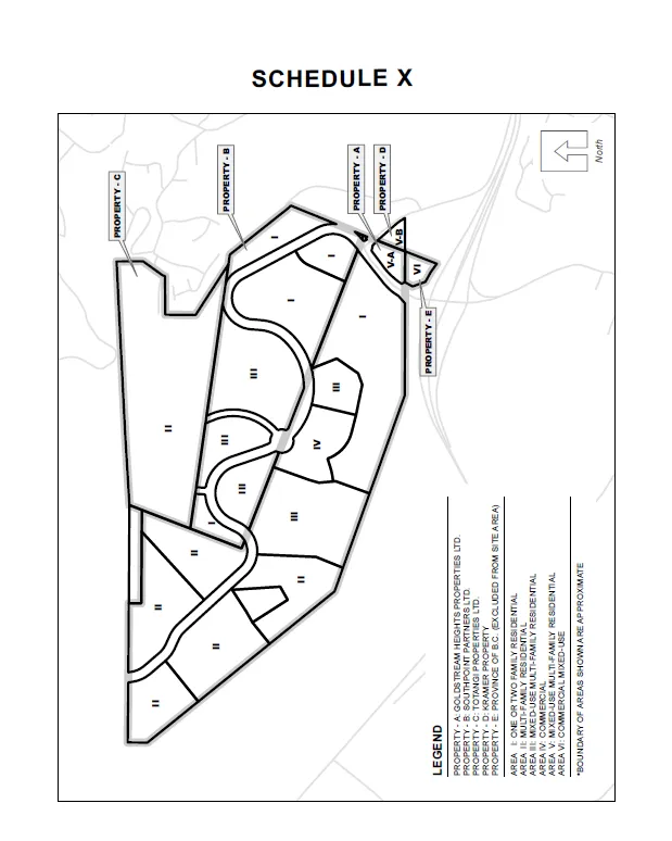
By replacing “Schedule X” with the map attached as Schedule C;
B. This Bylaw may be cited for all purposes as “Langford Zoning Bylaw, Amendment No. 453, (2131, 2181, 2160, 2200, 2250, 2251, 2300, 2350 Bear Mountain Pkwy; 2750 & 2751 Echo Valley Dr; 2588 Savory Rd; VIP87258 Lots 1-6), 2016".
READ A FIRST TIME this day of, 2016.
PUBLIC HEARING held this day of, 2016.
READ A SECOND TIME this day of, 2016.
READ A THIRD TIME this day of, 2016.
APPROVED BY THE MINISTRY OF TRANSPORTATION this day of , 2015.
ADOPTED this day of , 2016.
MAYOR
(Certified Correct)
CORPORATE OFFICER
Schedule A
Section 6.101 – Comprehensive Development – South Skirt Mountain (CD12) Zone
6.101.01 Permitted Uses
(1) Within that portion of the lands identified as “Area I – One or Two Family Residential”, on the CD12 zone map attached as Schedule “X”, the following uses and no others are permitted:
- (a) accessory buildings and uses;
- (b) assembly;
- (c) attached housing;
- (d) bed and breakfast in one-family dwellings on lots of 550 m2 (5 920 ft2) or greater in area and in accordance with Sec. 3.09;
- (e) community care facility including, but without limiting the generality of the foregoing: hospitals, private hospitals, nursing homes, and multi-level care facilities;
- (f) community garden;
- (g) group daycare limited in accordance with Section 3.26.02;
- (h) home occupation in accordance with Section 3.09;
- (i) one-family dwelling which may contain a secondary suite within the one-family dwelling in accordance with Section 3.08;
- (j) one-family dwelling which may contain a secondary suite within the one-family dwelling on lots with an area less than 550 m2 (5920 ft2);
- (k) one-family dwelling which may contain a secondary suite within the one-family dwelling in accordance with Section 3.08 or within an accessory building in accordance with Section 3.08.04 on lots with an area equal to or greater than 550m2 (5920 ft2);
- (l) schools, including preschools;
- (m) temporary construction and real estate marketing offices;
- (n) the keeping of not more than four boarders in a one-family dwelling;
- (o) townhouses;
- (p) two-family dwellings on lots with areas greater than or equal to 750 m2 (8073 ft2), a width of not less than 13 m (42.6 ft) and a building envelope width not less than 11 m (36.1 ft);
- (q) uses permitted by Section 3.01 of this Bylaw.
(2) Within those portions of the lands identified as “Area II – Multi-Family Residential” on the CD12 zone map attached as Schedule “X”, the following uses and no others are permitted:
- (a) apartments, including apartments for senior citizens;
- (b) assisted living apartment;
- (c) uses permitted by Section 6.101.01(1);
(3) Within those portions of the lands identified as “Area III” – Mixed-Use Multi-Family Residential” on the CD12 zone map attached as Schedule “X”, the following uses and no others are permitted:
- (a) church;
- (b) commercial uses in a mixed-use building, including:
- i. bakery;
- ii. offices;
- iii. personal service establishments, including, but without limiting the generality of the foregoing, barber shop, beauty parlour, launderette, optical or watch repair shop, photographic studio and shoe repair;
- iv. indoor recreation facilities;
- v. retail stores; and
- vi. restaurants and coffee shops, excluding drive-in and drive-through;
- (c) uses permitted by Section 6.101.01(1) and (2);
(4) Within those portions of the lands identified as “Area IV – Neighbourhood Centre” on the CD12 zone map attached as Schedule “X”, the following uses and no others are permitted:
- (a) accessory buildings and uses;
- (b) assembly and entertainment uses, including but without limiting the generality of the foregoing, auditoriums, banquet halls, billiard and pool halls, bowling alleys, catering establishments, and movie theatres;
- (c) bakery, limited to a gross floor area of 220 m2 (2,153ft2);
- (d) craft studio in enclosed buildings;
- (e) financial institutions, excluding drive-through;
- (f) food catering facilities;
- (g) hospital, including private hospitals, nursing homes and multi-level care facilities;
- (h) hotel and motel;
- (i) medical clinics;
- (j) offices;
- (k) parking facilities;
- (l) personal service establishments, including, but without limiting the generality of the foregoing, barber shop, beauty parlour, launderette, optical or watch repair shop, photographic studio and shoe repair;
- (m) post office;
- (n) premises licensed pursuant to the Liquor Control and Licensing Act;
- (o) indoor recreation facilities;
- (p) recreational facilities;
- (q) restaurants and coffee shops, excluding drive-in and drive-thru;
- (r) retail stores;
- (s) veterinary practices in enclosed buildings;
- (t) uses permitted by Section 6.101.01(1), (2) and (3);
(5) Within those portions of the lands identified as “Area V (a & b) – Commercial” on the CD12 zone map attached as Schedule “X”, the following uses and no others are permitted:
- (a) accessory buildings and uses;
- (b) accessory commercial uses, limited to the following;
- i. conference and meeting facilities
- ii. premises licensed pursuant to the Liquor Control and Licensing Act;
- iii. public assembly and entertainment uses;
- (c) car wash;
- (d) financial institution, including drive through;
- (d) gas station;
- (e) health club;
- (f) hotel and motel;
- (g) indoor recreation facilities;
- (h) offices;
- (i) parking facilities;
- (j) personal service establishments, including, but without limiting the generality of the foregoing, barber shop, beauty parlour, launderette, optical or watch repair shop, photographic studio and shoe repair;
- (k) public transportation depot;
- (l) restaurants and coffee shops, including drive-in and drive-through;
- (m) retail stores;
- (n) sale and repair of household furnishing;
- (o) temporary construction and real estate marketing offices;
- (p) uses permitted by Section 3.01 of this Bylaw.
(6) Within those portions of the lands identified as “Area VI – Commercial Mixed-Use” on the CD12 zone map attached as Schedule “X”, the following uses and no others are permitted:
- (a) accessory commercial uses, limited to the following;
- i. conference and meeting facilities;
- ii. group daycare in accordance with Section 3.26.02
- iii. medical clinic;
- iv. parking facilities;
- v. personal service establishments;
- vi. premises licensed pursuant to the Liquor Control and Licensing Act;
- vii. public assembly and entertainment uses;
- (b) apartments, including apartments for senior citizens;
- (c) attached housing;
- (d) car wash;
- (e) financial institution, including drive through;
- (f) gas station;
- (g) hotel and motel;
- (h) indoor recreation facilities;
- (i) offices;
- (j) recreational facilities;
- (k) residential hotel;
- (l) restaurants and coffee shops, including drive-in and drive-through;
- (m) retail stores;
- (n) temporary construction and real estate marketing offices;
- (o) townhouses;
- (p) uses permitted by Section 3.01 of this Bylaw.
6.101.02 Subdivision Lot Requirements
(1) In Areas I, II, III, and IV:
- (a) No lot having an area less than 200 m2 (2152 ft2) or a width less than 6 m (19.7 ft) may be created by subdivision;
- (b) No lot with an area greater than, or equal to 550 m2 (5 920 ft2) may be created having a width less than 10 m (32.8 ft);
- (c) Notwithstanding Section 6.101.02(1)(a), a lot having an area of no less than 70 m2 (750 ft2) and a width no less than 4m (13ft) may be created by subdivision for a townhouse use;
(2) In Areas V (a & b) and VI:
- (a) No lot having an area less than 695 m2 (7 480 ft2) may be created by subdivision;
- (b) No lot may be created having a lot width less than 16m (53ft);
(3) No land in the CD12 zone may be subdivided unless, concurrently with the subdivision, the Owner has granted to the City a covenant under section 219 of the Land Title Act restricting the use of the land being subdivided and the construction of buildings and structures on the land such that the land use and density regulations contained in the CD12 zone including the provisions for bonus density in Subsection 6.101.04(3) are made applicable to the individual parcels created by the subdivision in a manner that is consistent with this Bylaw and the Official Community Plan.
6.101.03 Density of Development on Individual Lots
(1) There may not be more than one residential building, exclusive of any secondary suite in an accessory building, on a lot with an area less than 750 m2 (8 073 ft2).
6.101.04 Density of Development in the CD12 Zone
(1) Within Area VI:
- (a) the floor area ratio may not exceed 1.0 for buildings containing uses other than residential uses and hotels; and
- (b) the floor area ratio may not exceed 2.0 for buildings containing residential or hotel uses.
(2) There may not be more than sixteen (16) dwelling units in Areas I, II, III, and IV of the CD12 zone;
(3) Despite Subsection 6.101.04(2), land in Areas I, II, III, and IV of the CD12 zone may be subdivided and land may be developed for more than sixteen (16) dwelling units if the owner of the land to be built upon has provided the following the following to the City:
- i. $2000 per dwelling unit towards the General Amenity Reserve Fund; AND
- ii. A covenant charging the land in CD12 zone, in terms satisfactory to the City, ensuring that land in an amount equal to at least 40% of the land area within the CD12 zone, and in a location satisfactory to the City, is dedicated as public land or protected as covenanted open space;
(4) For the purposes of Subsection 6.101.04(3) a dwelling unit is authorized in the CD12 zone when a building permit authorizing the construction of the dwelling unit is issued, except that in the case of a subdivision of land into lots on which the CD12 regulations permit the construction of a one- or two-family dwelling, dwelling units are authorized on such lots when the approving officer approves the subdivision plan creating the lots;
(5) For the purposes of Subsections 6.101.04(3) a dwelling unit is defined as a single residential lot of not less than 550 m2 (5920 ft2) or a single-family residential dwelling on a lot not less than 550 m2 (5920 ft2);
(6) For the purpose of Subsection 6.101.04(3):
- (a) A one-family dwelling on a lot less than 550m2 (5920 ft2) is deemed equivalent to 0.66 dwelling units;
- (b) A two-family dwelling unit (duplex) is deemed to be equivalent to 1.32 dwelling units (2 x 0.66);
- (c) A multi-family dwelling unit (townhousing, attached housing, apartment is deemed equivalent to 0.61 dwelling units;
(7) Provided that all of the requirements of Section 6.101.04 have been met, the maximum density of development within Areas I, II, III, IV, and V (a & b) of the CD12 zone is as follows:
- (a) within Area II:
- i. the floor area ratio may not exceed 3.0.
- (b) within Area III:
- i. the commercial uses {permitted by Section 6.101.01(3)(b)} may not exceed 600 m2 (6 458ft2); and
- ii. the floor area ratio may not exceed 7.0;
- (c) within Areas IV and V(a),
- i. the combined floor area for uses other than residential uses may not exceed 6,000 m2 (64 586 ft2);
- (d) Within Area V(b),
- i. the floor area for uses other than residential uses may not exceed 1,000 m2 (10 764 ft2);
- (e) Within Area VI, the floor area ratio may not exceed 7.0; and
- (f) Within Area V (a &b):
- i. the floor area ratio may not exceed 1.0 for buildings containing only uses other than hotels; and
- ii. the floor area ratio may not exceed 2.0 for buildings containing hotel uses.
(8) Under no circumstances may the total number of residential dwellings other than secondary suites and assisted living apartments and care facilities in Areas I, II, III and IV of the CD12 zone exceed 2000.
6.101.05 Lot Coverage
(1) Within Area V (a & b) and VI, the lot coverage of all buildings and structures may not exceed 50%;
6.101.06 Height and Size of Principal Use Buildings
- (1) Within Area I, the height of principal use buildings may not exceed three storeys;
- (2) Within Area II, the height of principal use buildings may not exceed six storeys, exclusive of up to two storeys primarily containing off-street motor vehicle parking spaces;
- (3) Within Area V (a & b) and VI, the height of principal use buildings may not exceed four storeys;
6.101.07 Setbacks
(1) Within Area V (a & b) and VI, no building or structure may be located:
- (a) Within 7.5 m (25 ft) of any front lot line;
- (b) Within 6 m (20 ft) of any interior side lot line that does not adjoin a lot in a commercial, industrial or business park zone;
- (c) Within 10 m (32.8 ft) of any rear lot line except that no setback is required from a rear lot line that adjoins a lot in a commercial zone, industrial zone, or business park zone; or
- (d) Within 6 m (20 ft) of any exterior side lot line.
6.101.08 Landscape Screening
(1) In addition to the regulations contained in Section 3.21 of this Bylaw, a continuous landscape and screening area not less than 3 m (10 ft) wide must be provided along the developed portion of each lot in Area V (a & b) and VI which abuts a highway, and a continuous landscape and screening area not less than 3 m (10 ft) wide or not less than 2.5 m (8 ft) in width containing a decorative fence not less than 1.8 m (6 ft) in height together with decorative planting must be provided along the developed portion of each lot in Area V (a & b) and VI which abuts a property in an agricultural, residential, or institutional zone other than the CD12 zone. The landscape and screening area may be interrupted at boulevard crossings, or to provide necessary pedestrian access for entering a building or for viewing shop windows. The width of the landscape area may include the width of any landscaped portion of the abutting highway that is contiguous with the landscape area and not separated from it by any paved, graveled or concrete area.
6.101.09 General
The relevant regulations of Part 3 of this Bylaw apply.
Schedule B
Appendix S: South Skirt Mountain
South Skirt Mountain Neighbourhood Design Guidelines
1.0 GENERAL
JUSTIFICATION
The City of Langford has designated all commercial, multi-family residential, and intensive residential development as a Development Permit Area pursuant to the provisions of the Local Government Act. The justification for this designation is to ensure that Council has the ability to secure the necessary information and establish conditions on development such that the form and character of new commercial, multi-family residential and intensive residential development are of a high quality and best suited to both the surrounding land and the vision of Langford as expressed in the Langford Plan.
OBJECTIVE
The objective of the South Skirt Mountain Design Guidelines is to supplement the Development Permit Guidelines for residential, multi-family, commercial, and hillside development within the City of Langford Development Permit Guidelines, specifically to guide development of properties identified as development areas within the South Skirt Mountain Neighbourhood Area Plan. These guidelines will ensure that development:
- a. encourages a development pattern that seeks to preserve and enhance existing landform, wetlands, and vegetation wherever possible,
- b. is constructed to high standards, both material and aesthetic, and
- c. is protected from hazardous conditions.
The essential nature of the South Skirt Mountain development is a high-quality mix of single- and multi-family residential and commercial uses. The form and character of the development and the design of the landscaping and pedestrian systems are important means to achieving this.
Where there is a conflict between these guidelines and the General Design Guidelines, the South Skirt Mountain Design Guidelines will take precedence.
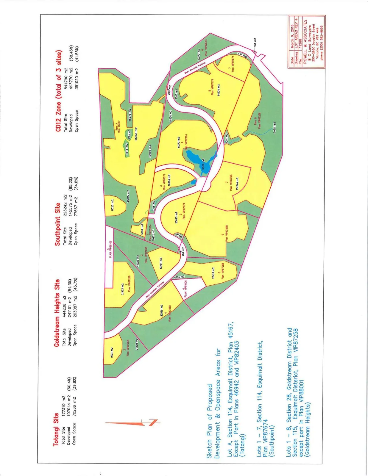
1.1 The South Skirt Mountain Development Neighbourhood Area Plan provides for single family, multi-family, commercial, institutional and recreational land uses. Map A1 identifies the general layout of development sites, mid-high density clustered areas, and dedicated open space areas, which will provide overall direction for the layout of development as a development permit guideline. While this layout is not intended to be inflexible, any deviation from the plan must be supported by substantial compliance with relevant development permit guidelines and an amended concept plan demonstrating that the overall layout concept meets the relevant guidelines and bylaw of the City of Langford;
1.2 The Director of Planning may issue variances with respect to any setback requirement, where the variance being sought supports the objectives of the design guidelines, including but without being limited to the following: respecting existing topography, natural features, areas of sensitive ecosystems, provision of public amenities and special architectural features;
2.0 ENVIRONMENTALLY SENSITIVE AND HAZARDOUS CONDITIONS
2.1 The South Skirt Mountain Neighbourhood Area Development Concept plan that forms part of these guidelines is based on the requirement that 40% of the lands within the CD12 (South Skirt Mountain Comprehensive Development) zone will be preserved either as covenanted open space, amenity land or dedicated park. The highest value sensitive ecosystems have been determined to be generally within the areas shown as Open Space on the map attached, but the true location of these ecosystems is to be determined, phase by phase, through the Development Permit process;
2.2 Land alteration is expected to occur only on a phase by phase basis, and must be preceded by a Development Permit that addresses, in particular: environmentally sensitive ecosystems, wildlife habitat and biodiversity, riparian areas, steep slopes and interface fire hazard, in accordance with the City’s guidelines for environmentally sensitive and hazardous DP areas.
2.3 A Development Permit may limit the scope of land alteration for the sake of mitigating environmental impact, hazardous conditions or aesthetic considerations;
2.4 Development will also be guided by the recommendations within the South Skirt Mountain Wildfire Interface Assessment Plan dated January 29, 2008 prepared by Strathcona Forestry Ltd.
3.0 GENERAL FORM AND CHARACTER GUIDELINES
3.1 Site grading should incorporate natural topography where possible. Where topography is not affected by development, natural features should be retained;
3.2 Building setbacks, orientation, form, density and height, should be designed to minimize the impact of the proposed development on ecosystems and existing topography.
3.3 Natural features or existing trees between clusters of development on hillsides should be retained (where supported by the qualified professional with respect to Interface fire hazard or ecosystem preservation) so as to enhance or protect views from outside of the area and avoid the view of a solid built mass on the hillside. Where retention of trees is not possible, establishing new landscaping with the same purpose is encouraged;
3.4 Site lighting should be designed so as to minimize light pollution. Exterior lights shall be permitted, as required for safety and comfort when installed at a height and angle so as to minimize glare onto adjacent lands. The use of full cut-off and shielded fixtures is encouraged wherever practical;
3.5 Parking may be provided between building entrances and the street frontage in order to minimize disturbance to sensitive ecosystems or natural topography, provided it is screened with suitable landscaping to minimize impact from the street.
3.6 Structured parking above grade should be designed and finished in a manner that is consistent with the overall building character, and designed to create overall architectural interest;
3.7 Parkade structures below grade may extend to the property line, and may be excluded from setback requirements;
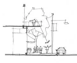
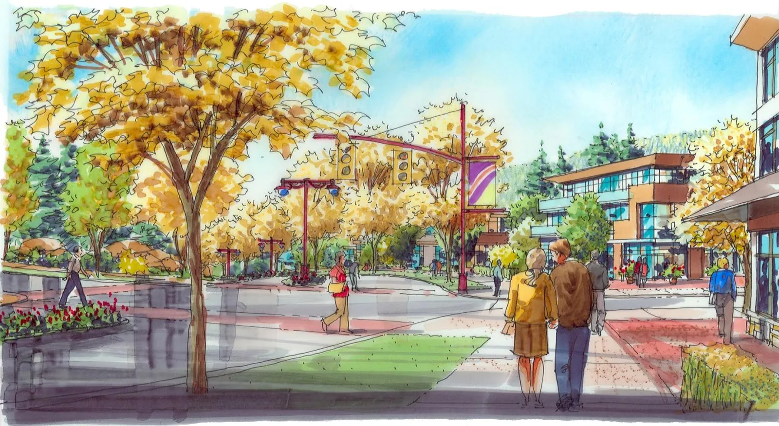
3.8 Overall, the form and character of development shall exhibit a blend of a traditional Arts and Crafts or Craftsman style of architecture that is consistent with the early history of British Columbia and more Modern and Contemporary styles of architecture that have become synonymous with a “West Coast” style of architecture. Architectural types that reflect national “types” (such as: Swiss Chalet or Spanish Hacienda) that are not generally associated with the local climate, geography or architectural pattern of development are discouraged. In order to achieve this design theme, individual buildings are encouraged to incorporate any or all of the following elements into their design:
- a) large timber framing at feature areas (where permitted from an interface fire hazard management perspective);
- b) Characteristic roof overhangs;
- c) Stepped building massing;
- d) Natural materials;
3.9 Buildings shall be constructed to a high material and architectural standard. Acceptable finishes include:
- a) Architectural concrete;
- b) Stucco;
- c) Wood;
- d) Cementitious board;
- e) Architecturally finished block;
- f) Architectural composite metal panels and pre-finished metal siding;
- g) Natural stone;
- h) Brick;
- i) Cultured stone;
4.0 MULTI-FAMILY and MIXED-USE DESIGN GUIDELINES
4.1 Within multi-building developments, buildings should not be identical, but should exhibit a form and character that is complementary. Buildings should establish the individual character of each building, while maintaining a common architectural theme that is consistent with the overall architecture of the zone;
4.2 Within multi-building, multi-storey developments greater than three storeys, the distance between any 2 buildings should not be less than 3 meters or half the height of the taller building, whichever is less, unless buildings are separated by a firewall in a zero lot line configuration;
4.3 Where ground oriented multi-family development (eg: townhouses) are situated directly adjacent to single-family residential development, the height of multi-family development at the street level should be less than 3 full storeys in height;
4.4 Building massing should step at the parking podium.
4.5 For buildings over six stories in height, the podium should be strongly articulated through:
- a. architectural details at human scale,
- b. stepping and terracing of the elevations of the podium, and
- c. Use of different building massing and primary building materials to that of the upper stories.
4.6 The grade level of buildings should be activated wherever possible, including walk-up residential, commercial, or personal service uses.
4.7 Common amenity space may be provided in the form of common rooms, shared outdoor space, fitness, or other facilities.
4.8 Terraced building articulations are encouraged, wherever possible.
4.9 Separation between buildings or portions of buildings that are more than 6 stories in height should not be less than 25 meters, excluding parking structure and podiums.
5.0 MIXED USE CORE DESIGN GUIDELINES
5.1 In addition to the guidelines contained in this section, the development permit area guidelines for “General Design Guidelines for Downtown Langford” contained in Bylaw 300 shall also apply to any Mixed Use Core within the CD12 (South Skirt Mountain Comprehensive Development) zone.
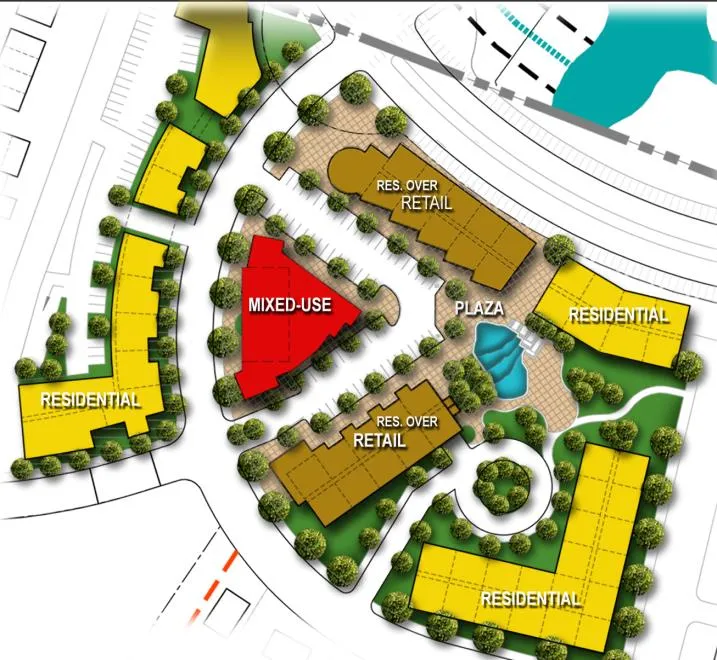
Typical Mixed Use Core
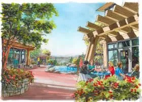
5.2 A Mixed Use Core should be designed to include and encourage public gatherings.
5.3 Specific features should include pedestrian friendly plazas and a landscaped courtyard with a central water feature.
5.4 Buildings surrounding the plaza should have main entrances fronting onto the plaza and, where possible, onto adjacent streets.
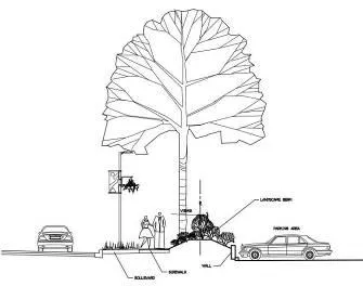
5.5 Restaurants and cafes should incorporate opportunities for outdoor sidewalk dining areas.
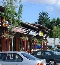
5.6 Store signage in the Mixed Use Core is permitted to have individually illuminated letters, providing they are designed to be consistent with the architectural character of the development.
6.0 COMMERCIAL DESIGN GUIDELINES
6.1 Commercial Design Guidelines below are applicable to Area V on the Land Use Plan, and are not applicable in the Mixed-Use Core.
6.2 New buildings should utilize variations in the character of rooflines, sloping roof lines, gables and dormers, or other interesting roof treatments that are complimentary to the design expressed in neighbouring buildings;
6.3 All portions of a site not covered by buildings, structures, and vehicle/pedestrian circulation space should either be retained in a natural condition or landscaped.
6.4 Setbacks from parking to a lot line adjoining a road can be reduced to 2 meters, provided the setback area includes an intensive landscape area adjacent to the street.
7.0 LANDSCAPING
7.1 Emphasize use of species present on-site for all natural areas and the interface to natural areas;
7.2 Trees and major shrub vegetation should be selected in consultation with a registered professional biologist to reflect the vegetation zone characteristics where it is situated i.e. Garry Oak/Rock Outcrop; Forest Upland; adjacent riparian zones, and the production and use of Garry Oak and Arbutus is encouraged.
7.3 Every effort should be made to reinforce, strengthen the edges of the adjacent natural areas. These edges should be blurred and allow the natural habitat to blend and extend into the development zones.
7.4 A limit of disturbance for each development zone shall be established with an evaluation and identification of vegetation areas for preservation. These areas shall be demarcated and protected prior to any clearing or disturbance of the site.
7.5 Ensure the protected and adjacent natural areas are protected from the adverse effects of rock removal, erosion, and changes in the hydrological ground conditions. Within the Garry Oak/ Rock Outcrop areas, evaluate trees and develop a rock removal plan strategy to an arborist’s approval that ensures adverse effects to the protected trees are prevented.
7.6 Topsoil and overburden shall be reclaimed on site, where practical, for re-use and use in natural interface areas.
7.7 Landscape areas are encouraged to use native species for site interface and a mix of native and non-native plants for areas associated with buildings, parking and feature areas.
7.8 Plant material should be arranged to emphasize building entrances, pedestrian and vehicular circulation routes, as well as to soften the appearance of parking areas, mechanical systems, and service areas without blocking visibility of pedestrian and vehicular traffic. Plants should be used to complement the scale of the area or structure.
7.9 Where practical, with respect to interface fire hazard, coniferous trees should be used to screen mechanical equipment and service areas. Space should be provided to allow a natural tree screening as opposed to hedges.
7.10 Landscape islands are to be provided internal to parking areas.
7.11 Landscaping should be arranged in a natural pattern or geometric configurations as designed by a Landscape Architect.
Schedule C
(Schedule C replaces "Schedule X" as the CD12 zone map referenced in this bylaw.)