DocumentsStaff ReportSep 21, 2026Pages 1–14
Staff Report to Council — Bylaw No. 2302 – Application to Rezone 3213 and 3217 Happy Valley Road
Staff report recommending consideration of rezoning City-owned properties at 3213 and 3217 Happy Valley Road from C1 and R2 to the new MU6A zone. The proposal would enable a six-storey mixed-use building with neighbourhood-serving commercial space, at least 4,500 sq ft of medical clinic space, and residential units.
Key facts
- Report date: September 21, 2026
- Application No. Z26-0010
- Combined site area: 1,535 m²
- Minimum 4,500 sq ft of medical clinic space
- Minimum 2,400 sq ft of ground-floor commercial space
Staff Report to Council
DATE: Monday, September 21, 2026
DEPARTMENT: Planning
APPLICATION NO.: Z26-0010
SUBJECT: Bylaw No. 2302 – Application to Rezone 3213 and 3217 Happy Valley Road from Neighborhood Commercial (C1) and One- and Two-Family Residential (R2) to Mixed Use Neighbourhood Village (MU6A) to allow a for a six-storey mixed use building, with active ground oriented commercial space, medical clinic space on the second floor, and four stories of residential units above.
EXECUTIVE SUMMARY
This application proposes to rezone City-owned lands located at 3213 and 3217 Happy Valley Road from the C1 and R2 zones to the MU6A zone to allow for the development of a six-storey mixed-use building consisting of at least 2,400 sq ft of ground-floor, street-activating commercial and service-oriented space, at least 4,500 sq ft of City-owned or leased medical clinic space on the second storey, and four storeys of residential units above. The proposed MU6A zone is being introduced through this application and is intended to support similar mixed-use developments within existing and emerging neighbourhood village centres.
BACKGROUND
Previous Applications
There are no recent Planning applications for these properties.
Table 1: Site Data
| Item | Details |
|---|---|
| Applicant | City of Langford |
| Owner | City of Langford |
| Civic Addresses | 3213 and 3217 Happy Valley Road |
| Legal Descriptions | LOT 1, SECTION 83, ESQUIMALT DISTRICT, PLAN VIP76810, PID 025-910-116 LOT 8, SECTION 83, ESQUIMALT DISTRICT, PLAN 10626, PID 003-727-271 |
| Size of Properties | 1,535 m², combined |
| DP Areas | Riparian |
| Zoning | Existing: C1 and R2 Proposed: MU6A |
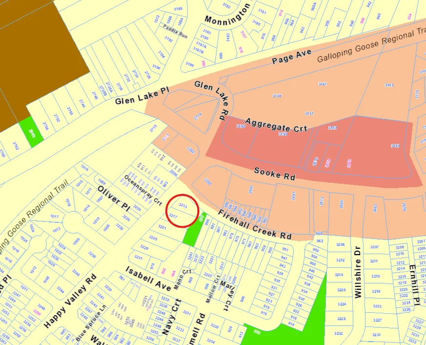
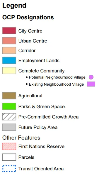
| OCP Designation | Existing: Neighbourhood Village, within Complete Community Proposed: no change |
Site and Surrounding Area
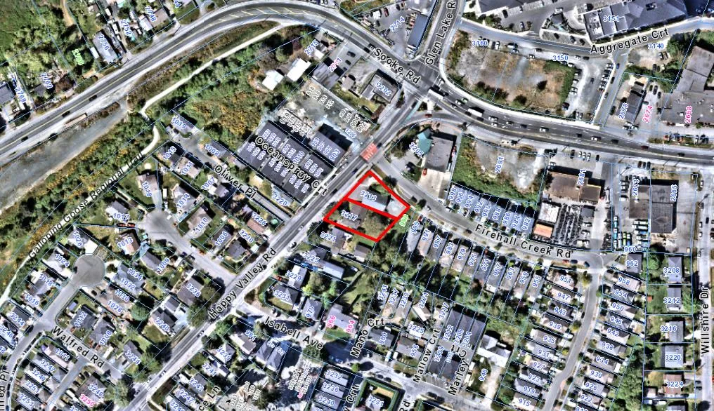
The subject properties are located on the corner of Happy Valley Road and Firehall Creek Road, south of Sooke Road. The property at 3213 Happy Valley Road contains a building used for storage of City equipment while 3217 Happy Valley Road contains an existing single-family dwelling. Neither building is proposed to be retained as part of this proposal.
Ernhill Park and Ed Fisher Memorial Park are all located within a fifteen-minute walk from the subject site. The Galloping Goose Regional Trail is located approximately 200 m from the proposed development site, with the closest access point off the Isabell Avenue cul-de-sac. Happy Valley Elementary School is located approximately 500 m away from the development site. School District No 62 has been made aware of this application such that they can consider the proposed increase in density in this area as part of their long-range facility planning.

The proposed development is also located within 800 metres of a Controlled Access Highway under the jurisdiction of the Ministry of Transportation and Transit (MoTT) and is therefore subject to provincial review and approval. During the referral stage of the application, MoTT did not identify any concerns with the proposal.
Table 2: Surrounding Land Uses
| Direction | Zoning | Use |
|---|---|---|
| North | P2 (Community Institutional) | Fire Hall Station 2 |
| East | P4 (Park and Open Space) | Dedicated Park |
| South | R2 (One- and Two-Family Residential) | Single-family dwelling |
| West | RT1 (Residential Townhouse) | Townhouse site currently under construction |
COMMENTARY
Development Proposal
The City has applied to amend the zoning designation of the subject properties at 3213 and 3217 Happy Valley Road from the Neighbourhood Commercial (C1) and One- and Two-Family Residential (R2) zones to a new Mixed-Use Neighbourhood Village (MU6A) zone to facilitate the development of a six-storey mixed-use building.
In July 2026, the City issued a Request for Proposal (RFP) seeking submissions for the development and purchase or long-term lease of these City-owned lands. The City’s objective is to facilitate a mixed-use development that delivers a critical community benefit in the form of approximately 4,500 sq ft of medical clinic space. In addition to this community asset, the development is intended to include active, ground floor commercial uses that serve the surrounding neighbourhood, an associated plaza or outdoor seating area, and residential units above, creating a vibrant, mixed-use neighbourhood hub.
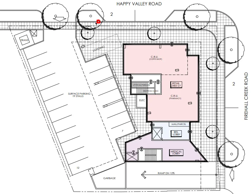
While the final design of the development will be prepared by the successful proponent of the RFP, the City engaged WA Architects to undertake a preliminary conceptual design study to assess site feasibility and illustrate one potential development scenario. The site plan from the Indicative Design Study is shown in Figure 2, below.
Although the final building design is not known at this stage, the RFP identifies several objectives that are considered fundamental and non-severable components of the development. As such, these following features are expected to be incorporated into the final proposal:
- A minimum of 4,500 sq ft of unfinished, contiguous medical clinic space designed to accommodate approximately 12 medical examination rooms and associated support areas;
- A minimum of 2,400 sq ft of contiguous ground-floor commercial space. Permitted uses within the proposed MU6A Zone include active, neighbourhood-serving commercial uses; and
- A corner outdoor patio or public plaza at grade to be provided in conjunction with the ground-floor commercial units.
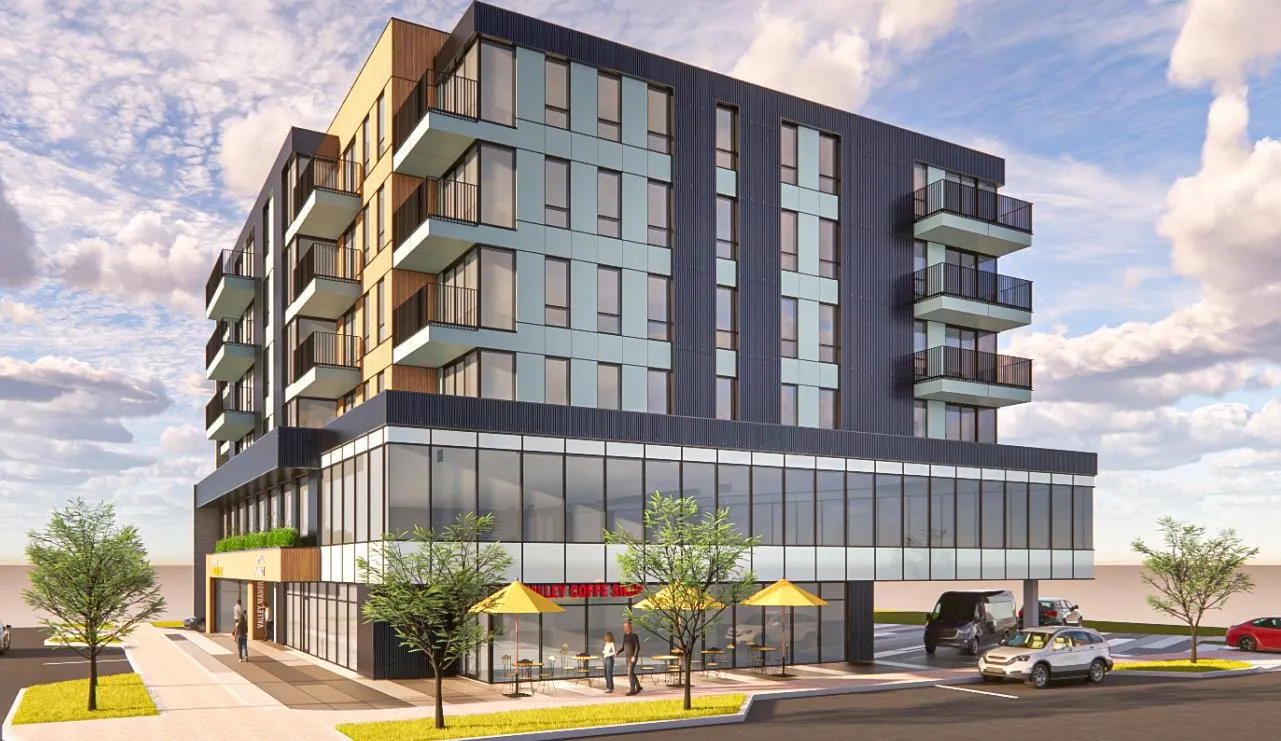
As part of the Indicative Design Study, WA Architecture also prepared a rendering of one potential design outcome for the future mixed-use building. The rendering is provided in Figure 3 below.
To stay consistent with previous rezonings of similar scale and density, Council may wish to direct staff to ensure that the building incorporates electric heat pumps or a central electric heat pump system. Additionally, considering the residential component will not be owned by the City, Council may direct staff to ensure that a covenant gets registered on title that ensures residential parking is allocated to each unit and visitors as required by the Zoning Bylaw No. 300 and are not provided in exchange for compensation separate from that of a residential unit. While such a covenant is usually secured prior to Building Permit issuance, Council may wish to require registration prior to Occupancy Permit due to the unique nature of the proposed land disposition.
TREES AND LANDSCAPING
In addition to the features outlined above, the RFP identifies a mature arbutus tree located along the western property line and partially within the road right-of-way that must be retained and protected during and after construction. Beyond the retention of this tree, the successful proponent will be required, through the Development Permit process, to submit a landscape plan prepared by a Registered Landscape Architect, which will form part of the permit.
The landscape plan must maximize both soft and hard landscaping opportunities on the site and demonstrate compliance with the landscaping requirements of Zoning Bylaw No. 300 and the Form and Character Development Permit Guidelines. This includes the provision of live landscaping covering a minimum of 10% of the total lot area, with at least one landscaped area having a minimum size of 35 m² and sufficient space to accommodate at least one tree. The plan must also provide a continuous landscape screening area with a minimum width of 1 m along the interior and rear property lines. In addition, where more than 20 apartment dwelling units are proposed, common outdoor amenity space must be provided in an amount equal to at least 5% of the lot area or 100 m², whichever is greater.
Table 3: Proposal Data
| Item | Permitted by C1 and R2 (Current Zoning) | Permitted by MU6A (Proposed Zoning) |
|---|---|---|
| Density (FAR and/or min. lot size) | C1: 0.5 or 1.0 R2: 400 m |
3.0 FAR |
| Height | C1: 9 m R2: 11 m |
Six storeys |
| Site Coverage | C1: 50% or 75% R2: 50% |
N/A |
| Front Yard Setback | C1: 2 m R2: 3 m or 5.5 m |
3 m |
| Interior Side Yard Setback | C1: 6 m (where abuts residential zone) R2: 1.5 m |
3 m |
| Exterior Side Yard Setback | C1: 7.5 m R2: 3 m or 5.5 m |
3 m |
| Rear Yard Setback | C1: 10 m R2: 3 m |
3 m |
| Vehicle Parking Requirement | In accordance with Part 4 | In accordance with Part 4 |
| Bicycle Parking Requirement | In accordance with Part 4 | In accordance with Part 4 |
The final design of the proposed mixed-use development is expected to comply with the requirements of the Zoning Bylaw No. 300. Any variances identified through the detailed design process can be considered by the Director of Community Planning and Development as part of the development permit approval process, where such variances optimize the site’s functionality and fulfills the intent of the Form and Character design guidelines.
Multi-Modal Network
FRONTAGE IMPROVEMENTS
Full frontage improvements will be provided in accordance Bylaw No. 1000. It is not anticipated that road dedication will be required along Happy Valley Road or Firehall Creek Road. The Director of Engineering and Public Works has noted that no Traffic Impact Assessment is required.
PEDESTRIAN, CYCLING AND MOTORIST NETWORK
Sidewalk infrastructure exists along both Happy Valley Road and Firehall Creek Road. While the sidewalk network along Sooke Road is not yet fully connected, each new development contributes additional segments that gradually create a more continuous and pedestrian-friendly environment.
Bicycle lanes are provided on both sides of Happy Valley Road and Sooke Road, offering cycling connections to the downtown core and surrounding areas. The Galloping Goose Regional Trail is also located within approximately 150 m of the subject site, providing additional cycling connectivity throughout the Greater Victoria region.
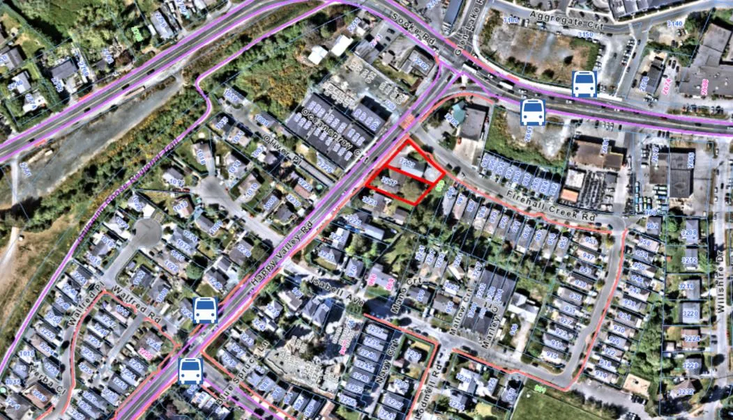
Several transit stops are located within walking distance of the development site, including two bus stops along Happy Valley Road south of the site and two bus stops along Sooke Road approximately 100 m northeast of the subject site. These stops are served by Routes 48, 52, 55, 59, 61, and 64, which operate at varying frequencies and provide connections to Langford Exchange, Metchosin, Royal Bay, Sooke, and downtown Victoria.
Infrastructure
DRAINAGE AND STORMWATER
The successful proponent of this project that will be chosen through the RFP process will be required to provide a stormwater management plan to the satisfaction of the Director of Engineering and Public Works.
SEWERS
A sewer main exists within both the Happy Valley Road and Firehall Creek Road frontages. A connection to the main will be required, and any improvements, extensions, or modifications needed to the sewer main within the municipal road right-of-way will be completed by West Shore Environmental Services.
CONSTRUCTION IMPACT MITIGATION
To ensure minimal impacts to the surrounding neighbourhood, Council may wish to direct staff to ensure that Construction Parking and Delivery Management Plan and Mitigation Plan are provided to the satisfaction of the Director of Engineering and Public Works, prior to any land alteration.
Additionally, the selected proponent will be required to sign an Acknowledgement Declaration to confirm that they have read, understood, and are committed to following City of Langford’s Good Neighbour Policy’s guidelines during the development process.
Council Policy
OFFICIAL COMMUNITY PLAN
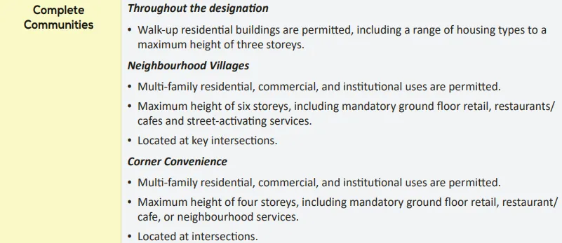
The Official Community Plan (OCP) Bylaw No. 2200 designated the subject properties as “Complete Communities”, which is defined by the following text:
Additional components relating to the Complete Communities designation include the following:
- 6.4 Desired Outcome #1: A diverse range of housing options- including various types, sizes, bedroom counts, ownership, and rental choices – will be available in neighbourhoods.
- 6.10.1. Subdivision and development must be connected to community sewer and water services.
- 6.4 Desired Outcome #2: Shops, services, and amenities will be easily accessible within a short walk, roll, or bike ride from homes, and supported by a well-connected network of streets, pathways, and public spaces.
- 6.4.3. Neighbourhood Villages are permitted in this designation and can emerge or expand specifically at key intersections as identified on Map 2, or other intersections meeting similar access criteria.
- 6.4.4. Additional opportunities to create Neighbourhood Villages in South Langford will be considered, where strategically advantageous and based on community needs.
- 6.4.5. Buildings up to six storeys in height, including mandatory street-activating and neighbourhood-serving retail stores, restaurants/cafés, and local-serving community services on the ground floor, are permitted in Neighbourhood Villages. Second floor non-residential uses may be considered where substantial community benefit is achieved.
6.4.6. Ground floor uses in buildings within Neighbourhood Villages will be individually small-scale, and will wrap around the corner of the building along the side-street frontage, have no or limited on-site parking, and are encouraged to incorporate a patio or plaza at the corner.
6.6.1.(1) Allow Urban Centres and Neighbourhood Villages to emerge in order to improve access to shops, services, and amenities.
8.3.1. Additional density to create Neighbourhood Villages and Corner Convenience is encouraged in the Complete Communities designation in accordance with the associated policies.
As outlined in these policies, the OCP supports the emergence of new Neighbourhood Villages in appropriate, accessible locations, where new mixed-use development can enhance access to local-serving shops, restaurants, services, and gathering spaces. The subject site is well positioned to fulfill this role, given its strategic location in a neighbourhood that has experienced significant growth in recent years and its proximity to the intersection of Sooke Road (Highway 14) and Happy Valley Road, the primary transportation corridors serving South Langford. The site is also supported by an established and expanding active transportation network, including sidewalks, bike lanes, and the Galloping Goose Regional Trail, making it readily accessible to both existing and future residents.
The OCP also contemplates second floor non-residential uses in Neighbourhood Villages, where substantial community benefit can be demonstrated. Council may wish to consider the proposed second floor medical clinic as a significant community benefit, given that this would help address the growing demand for healthcare services in the area. As such, that this component of the proposal is also consistent with the intent of this policy.
Council may wish to note that both the local-servicing ground floor uses and second floor medical clinic were identified as mandatory components of the City's Request for Proposal process to advance these key OCP objectives and support the creation of complete, walkable communities.
If Council is satisfied that the proposal is consistent with the objectives if the OCP and represents an appropriate evolution of this site as an emerging Neighbourhood Village, they may wish to consider this application.
DEVELOPMENT PERMIT AREAS
The subject properties are located in the Riparian Development Permit Area. Prior to any alteration of land, the applicant will be required to obtain a Development Permit, which will outline any requirements arising from a qualified professional's review of the proposal and site conditions in relation to the applicable Guidelines. As the development site is located within the 30 m Riparian Assessment Area (RAA) associated with the stream, a Riparian Areas Protection Regulation (RAPR) assessment prepared by a Registered Professional Biologist will be required for submission to, and approval by, the Ministry of Water, Land and Resource Stewardship. The approved assessment will subsequently be appended to the Development Permit.
Additionally, given the use and density of development, a Form and Character Development Permit will be required to ensure the final design complies with the standards prescribed in Zoning Bylaw No. 300, as well as the applicable Form and Character Development Permit Area Guidelines.
LOW CARBON CONCRETE
In accordance with Council’s Low Carbon Concrete Policy POL-0167-PLAN, Council may wish to require the project to utilize ready-mix concrete that meets or exceeds the weighted average Global Warming Potential targets based on Concrete BC Baseline (average) mix data for the construction of the proposed development.
FINANCIAL IMPLICATIONS
Rezoning the subject properties to permit higher density of development will increase the assessed value of lands and development will eventually increase municipal revenue due to the number of units created. A summary of Amenity Contributions and Development Cost Charges that the developer will be expected to pay, is outlined in Tables 4 and 5 below.
Inclusionary Zoning Bylaw
The City’s Inclusionary Zoning (IZ) Bylaw No. 2270 has recently replaced the Attainable Housing Policy and therefore, the project would need to comply with the new IZ Bylaw. Under this Bylaw, the development, depending on the final design and residential unit count, will be required to either provide attainable housing, or cash-in-lieu. The obligation and options for meeting the requirement are outlined in Bylaw No. 2270, and do not need to be secured in the covenant or bylaw.
Councils Amenity and Development Cost Charge Bylaws
The charges that would apply to this development in accordance with Council’s Amenity Cost Charge (ACC) and Development Cost Charge (DCC) Bylaws are summarized in Tables 4 and 5 below. The total amounts will be known once the final design has been produced. Council may wish to note that as per ACC Bylaw No. 2275, the charge is not payable in relation to any affordable and special needs housing units that are provided under an Inclusionary Zoning Bylaw, therefore the final calculation would exclude any such units if provided as part of the development.
Table 4 – Amenity Cost Charge
| Amenity Item | Per unit / area contribution |
|---|---|
| Amenity Cost Charge | $3,050 per residential apartment dwelling unit $10.75 per m2 of commercial GFA |
Table 5 - Development Cost Charges
| Development Cost Charge | Per Unit Contribution |
|---|---|
| Roads | Residential: $3,092.39 Commercial: $54.12 per m2 GFA |
| Storm Drainage | Residential: $635.00 Commercial: $4.58 per m2 GFA |
| Park Improvement | Residential: $1,348.00 |
| Park Acquisition | Residential: $90.00 |
| ISIF | Residential: $331.65 Commercial: $140/1000 ft2 GFA |
| CRD Water | Residential: Based on the number of resulting units Commercial: $10.48/ m2 GFA |
| School Site Acquisition | Based on the number of resulting units |
LEGAL IMPLICATIONS
Should Council choose to proceed with consideration of Bylaw No. 2302, the application will be prohibited from being the subject of a Public Hearing, as per the changes made by the Province to the Local Government Act through The Housing Statutes (Residential Development) Amendment Act, 2023.
The Amenity Cost Charges and Development Cost Charges applicable to the project are outlined in Tables 4 and 5 above and will be payable at the time of building permit. The total amount will be known once the design of the building is complete.
OPTIONS
Option 1
THAT Council:
- Give Bylaw No. 2302 1st, 2nd, and 3rd readings to amend the zoning designation of the properties located at 3213 and 3217 Happy Valley Road from Neighbourhood Commercial (C1) and One- and Two-Family Residential (R2) to Mixed-Use Neighbourhood Village (MU6A);
AND
Direct staff to ensure that the following occurs with this proposed development at 3213 and 3217 Happy Valley Road:
a. That any future permits that are to be issued include the features that are identified as mandatory and non-severable by the Request for Proposal associated with this development;
b. That the properties be consolidated prior to issuance of a Development Permit for Form and Character;
c. That the following be provided and implemented to Bylaw No. 1000 standards to the satisfaction of the Director of Engineering and Public Works prior to the issuance of a building permit:- Full frontage improvements; and
- A storm water management plan.
d. That the following be provided and implemented to Bylaw No. 1000 standards to the satisfaction of the Director of Engineering and Public Works prior to any land alteration: - A Parking Construction Management Plan; and
- A Mitigation Plan.
e. That a covenant be registered prior to issuance of an Occupancy Permit for the proposed development that ensures residential parking is allocated to each unit and visitors as required by the zoning bylaw and is not provided in exchange for compensation separate from that of a residential unit;
f. That the building be constructed with electric heat pumps for each individual unit or a central electric heat pump system;
g. That all concrete used on-site will utilize ready-mix concrete that meets or exceeds the weighted average Global Warming Potential targets based on Concrete BC Baseline (average) mix data, and that prior to the issuance of a Building Permit the applicant shall provide a Type III Environmental Product Declaration that is 3rd party verified specifying the total Global Warming Potential value and confirming that the proposed development meets the requirements of Low Carbon Concrete Policy POL-0167-PLAN;
OR Option 2
THAT Council take no action with respect to this application to rezone 3213 and 3217 Happy Valley Road under Bylaw No. 2302 until such time as the following items are addressed:
a. ______________;
b. ______________;
c. ______________;
SUBMITTED BY
Anastasiya Mysak, Planner I
Concurrence: Leah Stohmann, RPP, MCIP, Director of Community Planning and Development
Concurrence: Melisa Miles, Manager of Legislative Services
Concurrence: Donna Petrie, Senior Manager of Communications & Economic Development
Concurrence: Yari Nielsen, Director of Parks, Recreation and Facilities
Concurrence: Katelyn Balzer, P.Eng., Director of Engineering and Public Works
Concurrence: Michael Dillabaugh, CPA, CA, Director of Finance
Concurrence: Marie Watmough, Director of Legislative & Protective Services
Concurrence: Braden Hutchins, Deputy Chief Administrative Officer
Concurrence: Darren Kiedyk, Chief Administrative Officer
Attachments:
Bylaw No. 2302
Document Images
(4)
Related Documents
(5)Zoning Bylaw
Bylaw No. 300 · Referenced in 2 sections
Subdivision and Development Servicing Bylaw
Bylaw No. 1000 · Referenced in 2 sections
Official Community Plan Bylaw
Bylaw No. 2200 · Referenced in 1 section
Inclusionary Zoning Bylaw
Bylaw No. 2270 · Referenced in 1 section
Amenity Cost Charge Bylaw
Bylaw No. 2275 · Referenced in 1 section