DocumentsStaff ReportFeb 2, 2026Pages 27–43
Staff Report to Sustainable Development Advisory Committee: Bylaw No. 2250 – Rezoning 1029 Marwood Avenue (Z25-0006)
Staff report recommending Council consider Bylaw No. 2250 to rezone 1029 Marwood Avenue from RR2 to RS1 to permit creation of three small residential lots and to set conditions including amenity contributions and engineering requirements.
Key facts
- Civic address: 1029 Marwood Avenue
- Application: Z25-0006 (Bylaw No. 2250)
- Applicant/agent: Grayland Consulting Ltd. (Rachael Sansom) on behalf of Douglas Jay Wheldon and Carol Gail Obleman
- Proposed: rezone RR2 to RS1 to create three new lots (retain existing dwelling on remainder lot)
- Amenity contributions: $660 per new lot to Affordable Housing Reserve Fund; $3,960 per new lot to General Amenity Reserve Fund; total policy contributions for 3 lots $13,860
Staff Report to Sustainable Development Advisory Committee
DATE: Monday, January 19, 2026
DEPARTMENT: Planning
APPLICATION NO.: Z25-0006
SUBJECT: Bylaw No. 2250 – Application to Rezone 1029 Marwood Avenue from Rural Residential 2 (RR2) to Residential Small Lot 1 (RS1) to allow a three-lot subdivision.
Executive Summary
Rachael Sansom of Grayland Consulting Ltd. has applied on behalf of homeowners, Douglas Jay Wheldon and Carol Gail Obleman, to rezone 1029 Marwood Avenue from RR2 (Rural Residential 2) to RS1 (Residential Small Lot 1) to facilitate the creation of three new intensive residential lots from Brown Road. The proposal includes retaining the existing single-family dwelling and accessory building on the remainder lot fronting Marwood Avenue. It also includes approximately 4.5 m of road dedication along Brown Road, as well as frontage improvements on both Marwood Avenue and Brown Road. No variances have been requested to support this proposal.
Background
Previous Applications
In 2022, the City received a rezoning application (Z22-0029) to rezone the subject site to create three new lots. This application was subsequently closed due to inactivity.
Table 1: Site Data
| Item | Details |
|---|---|
| Applicant | Rachael Sansom (Grayland Consulting Ltd.) |
| Owner | Douglas Jay Wheldon and Carol Gail Obleman |
| Civic Address | 1029 Marwood Avenue |
| Legal Description | Lot 6, Block 3, Section 86 and 87, Metchosin District, Plan 1718 |
| Size of Property | 2,214 m² |
| DP Areas | Intensive Residential |
| Zoning | Existing: RR2 Proposed: RS1 |
| OCP Designation | Existing: Complete Community Proposed: Complete Community |
Site and Surrounding Area
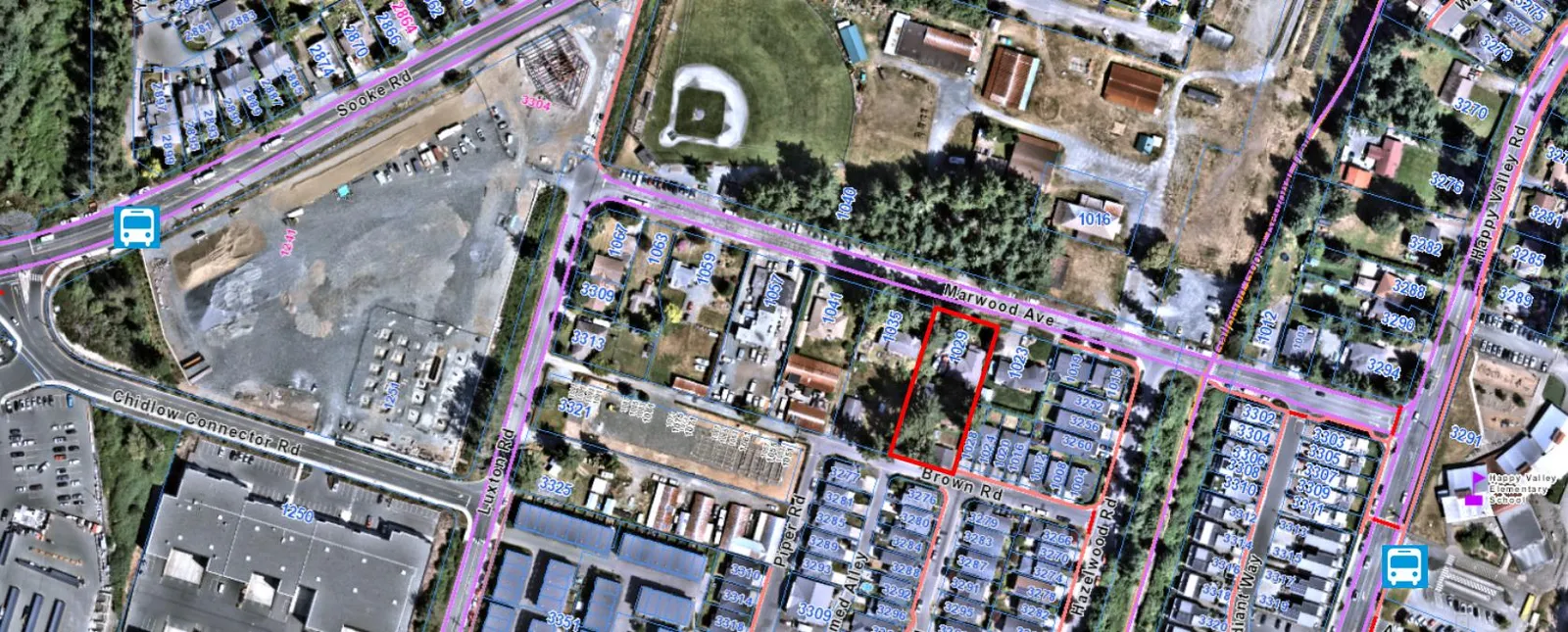
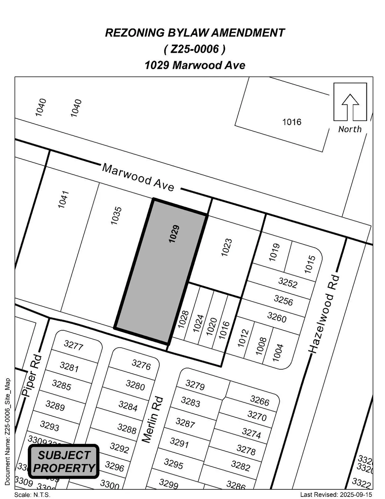
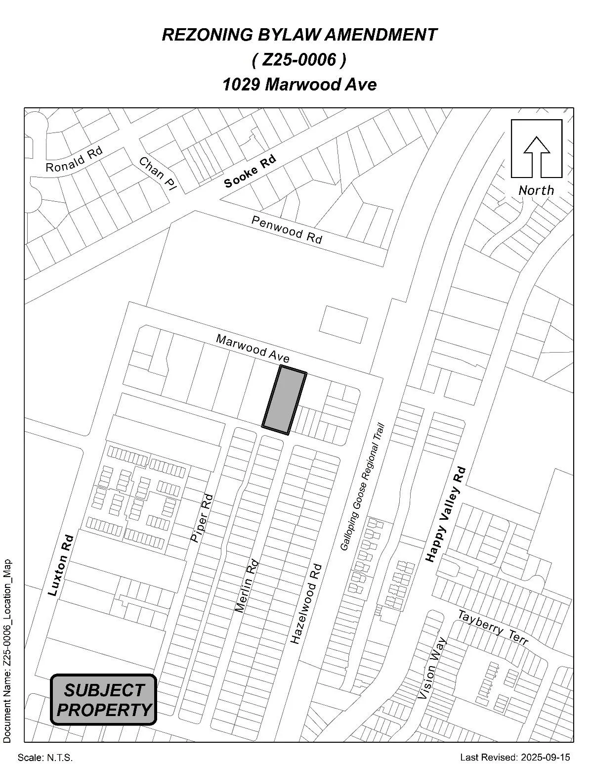
The subject property is located south of Sooke Road, with access off Marwood Avenue. The parcel is flat in nature and contains an established single-family dwelling and multiple accessory structures. There are a few mature trees located throughout the site, primarily concentrated in the northwest and southwest corners of the property. An arborist report has been submitted for the property and will be discussed later in this report.
The subject property is one of the remaining larger estate lots in the area; however, densification of the neighbourhood through the introduction of small-lot subdivisions as well as several townhome sites is evident.

Further west from the subject site, across Luxton Road, are Employment Lands and recently developed Pacific Ridge Business Centre. Chidlow Park playground and Luxton Baseball Park are located within 150 m of the subject site. The Luxton Fairgrounds are located right across Marwood Avenue and offer a variety of family-oriented events throughout the year. An access point to the Galloping Goose Regional Trail is located approximately 100 m east of the site. Happy Valley Elementary School is located approximately 300 m away from the site. School District No 62 has been made aware of this application.
The proposed development is located within 800 m of a Controlled Access Highway under the jurisdiction of the Ministry of Transportation and Transit (MoTT) and is therefore subject to their review and approval. During the referral stage of the application, MoTT did not identify any concerns with the proposal and indicated that they have no objection to the proposal in principle.
Table 2: Surrounding Land Uses
| Direction | Zoning | Use |
|---|---|---|
| North | P4 | Residential, Luxton Fair Ground |
| East | R2, RT2 | Single-family residential, duplex |
| South | CD14 | Intensive residential single-family lots |
| West | RR2 | Large lot residential |
Commentary
Development Proposal
The applicant proposes to rezone the subject site from RR2 to RS1 to enable the creation of three additional lots. Under the current RR2 zoning designation, the minimum lot size that can be created by subdivision is 4 ha (9.9 ac), which eliminates subdivision potential for the site. Although there are no current plans to redevelop the remainder lot on which an established single-family dwelling is planned to be retained, the proposal is to rezone the entire property at this time to allow the flexibility to redevelop this lot in the future under the same RS1 zoning. The three new proposed lots will be accessed and addressed from Brown Road, while the remainder lot with the retained home will continue to use its existing access and address from Marwood Avenue.
The proposed subdivision layout is shown below.
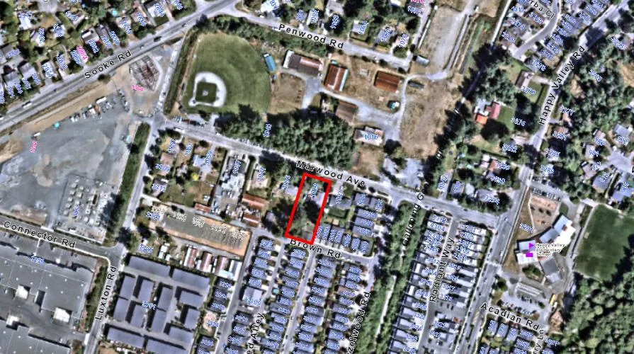
The RS1 zone was amended in 2024 to integrate the Small-Scale Multi-Unit Housing (SSMUH) regulations, as required by the Provincial Government. These regulations aim to improve housing choices within traditionally single-family neighbourhoods by allowing greater housing diversity, affordability, and inclusivity. Based on the proposed lot sizes, the RS1 Zone would allow each of the three newly created parcels to have up to three dwelling units in the prescribed forms identified within the Zone, while the remainder lot could either be developed with up to four dwelling units or re-subdivided. Given this, if Council proceeds with rezoning the subject property to RS1, the site could accommodate up to 13 dwelling units across the four lots, if each lot was developed to its full density potential. Additional units may be possible if the remainder lot is further subdivided.
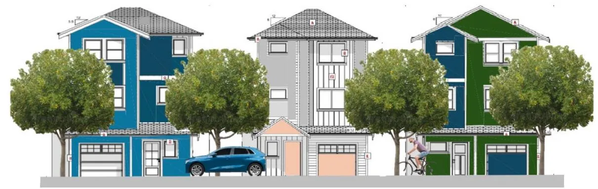
As the applicant intends to sell the newly created lots, the exact housing typology and density is unknown at this time. The applicant has provided a representative streetscape illustrating a potential single-family residential form.
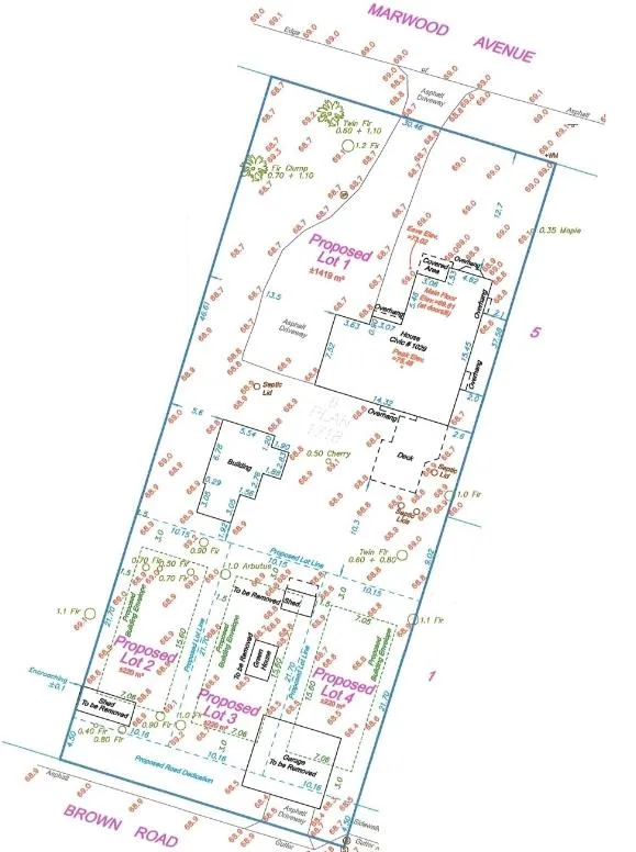
Table 3: Proposal Data
| Item | Permitted by RR2 (Current Zoning) | Permitted by RS1 (Proposed Zoning) |
|---|---|---|
| Permitted Use | • Dwelling, one-family • Dwelling, two-family + several rural residential uses |
• Dwelling, one-family • Dwelling, two-family • Townhouse |
| Density (minimum lot size) | 4 ha (9.9 ac) | 200m² |
| Height | 10.5 m | 11 m |
| Site Coverage | n/a | 50% or 60% for townhouse use |
| Front Yard Setback | 7.5 m | 3 m, or 6 m for garage/carport |
| Interior Side Yard Setback | 3 m | 1.5 m |
| Exterior Side Yard Setback | 3 m (5.5 m for garage/carport) | 3 m, or 6 m for garage/carport |
| Rear Yard Setback | 10 m | 3 m |
| Vehicle Parking Requirement | 2 per dwelling unit | 1 per dwelling unit |
PERMITTED DENSITIES
During the review of this proposal, staff discovered that the RS1 zone contains a clause that unnecessarily restricts the density potential of the newly created lots within RS1 zoning designation.
Section 6.20.02(2): Despite Subsection 6.20.02(1), on land whose legal description is set out in Table 1 Schedule AD, the minimum lot area for subdivision of lots for a one-family dwelling use may be 200 m² (2,153 ft²) if the owner of the land proposed to be subdivided: (a) Pays to the City the amount specified in Column 4 of Table 1 of Schedule AD, prior to the time of subdivision;
In essence, the clause states that lots with an area of 200 m² can only be created by subdivision for a one-family dwelling use, subject to Amenity Contributions. This regulation affects both the current proposal and similar subdivision applications within the RS1 zone because the densities permitted by SSMUH legislation apply only to new lots of 850 m² and larger. New lots between 200m² to 850m² can only be created for single-family use. Since the reference to “one-family dwellings” was mistakenly left in the subdivision section of this Zone and now prevents the effective implementation of the SSMUH-related density provisions, Council may wish to direct staff to amend the clause by removing this reference. The revised clause would read as follows:
Proposed amendment to Section 6.20.02(2): Despite Subsection 6.20.02(1), on land whose legal description is set out in Table 1 Schedule AD, the minimum lot area for subdivision may be 200 m² (2,153 ft²) if the owner of the land proposed to be subdivided: (a) Pays to the City the amount specified in Column 4 of Table 1 of Schedule AD, prior to the time of subdivision;
This amendment would allow new lots subdivided within the RS1 zone to achieve the intended increased densities associated with the SSMUH updates while ensuring that the City retains the ability to collect the required amenity contributions.
Arborist Report
The applicant submitted an arborist report that surveyed all existing trees on and immediately surrounding the site whose root systems may be impacted by the proposed development. The arborist identified 11 trees that would need to be removed under the current proposal to accommodate future building envelopes, new driveways, and servicing required for the development. The full arborist report provided by the applicant is attached to this report for reference.
Two of the 11 trees identified for removal (denoted OS2 and 887) are situated on neighbouring property or along the property line shared with the adjoining neighbour. The applicant has provided written authorization from the affected property owners permitting the removal of those trees to facilitate the development.
No environmentally sensitive Development Permit Area designation apply to the site or neighbouring properties, so tree removal is regulated by Tree Protection Bylaw No. 2206. Under this Bylaw, a tree removal permit may be issued for trees located within a building envelope, within the footprint of utility service or a driveway, or for trees located outside these areas that would be critically impacted by the proposed development.
Multi-Modal Network
Frontage Improvements
The applicant is proposing to dedicate 4.5 m of road along Brown Road frontage. The Director of Engineering has reviewed and approved the preliminary frontage drawing for this proposal, and noted that full frontage improvements to Bylaw No. 1000 will be required along Brown Road as well as Marwood Avenue, including but not limited to the following:
- Brown Road: 4.5 m road dedication, concrete sidewalk, paving to centre line, and landscaped and irrigated boulevard.
- Marwood Avenue: 1.8 m wide concrete sidewalk, separated landscaped boulevard with street trees, streetlights, and irrigation.
These frontage improvements will be required prior to subdivision approval or Building Permit issuance, whichever occurs first.
Pedestrian, Cycling and Motorist Network
The frontage improvements to be constructed as part of this development include a sidewalk within both frontages, which will contribute to greater pedestrian connectivity in the neighbourhood.
Together with the frontage and road improvements facilitated by the recently approved development on the corner of Luxton and Brown Road, Brown Road is expected to become a functional roadway. As a result, the addition of three new small lots is not expected to negatively impact the existing road infrastructure in the neighbourhood.
Bike lanes exist on both sides of Marwood Avenue, Luxton Road, Happy Valley Road, and Sooke Road, providing bicycle access to the downtown core and beyond. The Galloping Goose Trail is also within 100 meters of the subject site, offering cycling connections throughout the Greater Victoria region.
There are several bus stops within walking distance of the subject property, the closest being bus stops along Happy Valley Road serviced by routes 48, 52, 55, and 64. Additional bus stops are located at the intersection of Sooke Road and Chidlow Connector Road and the intersection of Sooke Road and Penwood Road, both serviced by route 61. Route 48 offers service to and from downtown Victoria during peak commuting hours. Route 52 runs throughout the day to provide service between the Colwood Exchange and Bear Mountain. Route 55 offers connection to Langford Exchange which in turn offers transfers to many other routes, including Blink Rapid Line 95. Route 64 travels from Langford Exchange to Sooke Town Centre via Happy Valley Road. Route 61 operates in an east-west direction between the District of Sooke and the Victoria Downtown Core, primarily travelling along Sooke Road.
Infrastructure
Stormwater Management
The applicant will be required to provide a stormwater management plan to the satisfaction of the Director of Engineering prior to the issuance of a building permit. As part of their rezoning application, the applicant has submitted a stormwater technical memo prepared by an Engineer outlining how they plan to adequately manage stormwater on-site. This memo has been reviewed and approved by the Director of Engineering.
Sewers
A sewer gravity main exists along Brown Road near the subject site. A connection from this main to all the new proposed lots as well as the remainder lot would be required. The existing septic field would have to be decommissioned, with the new sewer connection proposed to extend through the rear yard, between two of the proposed lots. Any improvements, extensions, and modifications to the sewer main within the municipal road right-of-way will be completed by West Shore Environmental Services at the applicant’s expense.
Potential Nuisances
Council may wish to require the applicant to register a Section 219 Covenant on title prior to Bylaw Adoption to notify future landowners of the potential nuisance uses that exist near the site. These include a variety of agricultural uses, the South Vancouver Island Rangers (gun/shooting range), and the Luxton fair grounds, which holds major public events bi-annually as well as smaller events throughout the year. These events can generate noise and light beyond what is typically expected in a residential neighbourhood. A Section 219 Covenant in this regard would ensure that the future landowners understand and accept the potential disruptions associated with these pre-existing uses in the area.
Construction Impact Mitigation
The applicant has been made aware of the City’s Early Guidance for Construction Impact Management document. Council may wish to require a Construction Parking and Deliveries Management Plan as well as an Erosion and Sediment Control Plan as a condition of rezoning and require that it be provided to the satisfaction of the Director of Engineering prior to any land alterations. Additionally, as per Section 2.5 of Bylaw No. 1000, a Mitigation Plan is required prior to land alteration to the satisfaction of the Director of Engineering. A Mitigation Plan is required where there are reasonable grounds to anticipate any discharge of contaminants, pollutants, silts, airborne particulates (dust) or materials (toxic or natural) to watercourses, municipal ditches and sewage systems, public or private lands, waters or the atmosphere. The construction impact mitigation measures should be secured within a covenant, prior to Bylaw Adoption.
Neighbourhood Consultation
In September 2025, 46 notices were hand delivered by the landowner to the residents of the immediate area, advising them of the rezoning application. The contact information of landowners’ agent was included to allow the residents to reach out with their commentary or concerns. At the time of writing this report, the applicant indicated that no concerns had been raised by the recipients of the notice.
Council Policy
Official Community Plan
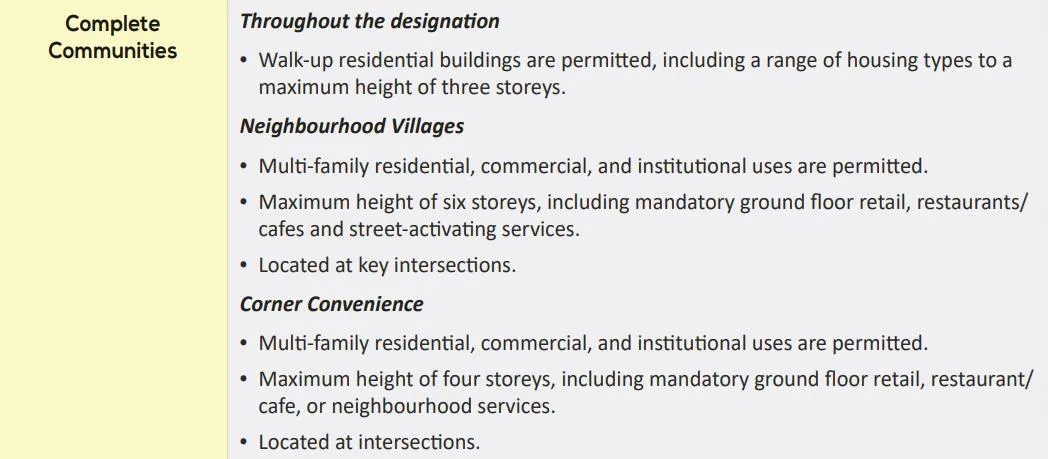
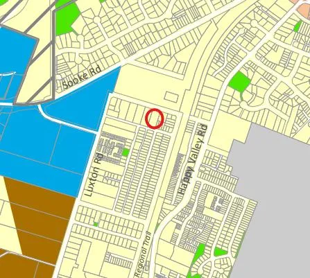
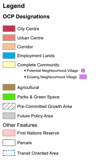
The Official Community Plan (OCP) Bylaw No. 2200 designated the subject properties as “Complete Communities”.
Additional components relating to the Complete Communities designation include the following:
- 6.4 Desired Outcome #1: A diverse range of housing options- including various types, sizes, bedroom counts, ownership, and rental choices – will be available in neighbourhoods.
- 6.4.1. A range of ground-oriented homes up to three storeys in height are permitted everywhere in this designation, subject to servicing. These include single-detached homes, duplexes, townhomes (including rowhouses and multi-plexes), and three-storey apartments. Accessory suites in attached and detached forms will be enabled as appropriate in the Zoning Bylaw.
- 6.10.1. Subdivision and development must be connected to community sewer and water services.
As the RS1 zone was recently amended to allow for greater flexibility in housing topologies in alignment with the SSMUH regulations, rezoning the site to RS1 would better align with the OCP, as it supports the objective of diversifying low to mid-density housing options within this OCP designation.
Development Permit Areas
The subject property is not located in any of the environmentally sensitive or hazardous Development Permit Area designations.
If the owner proceeds with the construction of three single-family dwellings as shown on the representative drawing of possible streetscape, the development will not be subject to a Form and Character Development Permit under the Design Guidelines and Development Permit Areas (Appendices to Zoning Bylaw No. 300) as subdivisions containing 3 or fewer new intensive residential lots are exempt. If, however, a future owner of one of the lots wishes to proceed with a higher density proposal permitted in the RS1 zone - such as duplex or a three-unit townhome - a Form and Character Development Permit pursuant to the respective design guidelines will be required prior to the issuance of a Building Permit.
Low Carbon Concrete
In accordance with Council’s Low Carbon Concrete Policy POL-0167-PLAN, Council may wish to require the applicant to utilize ready-mix concrete that meets or exceeds the weighted average Global Warming Potential targets based on Concrete BC Baseline (average) mix data for the construction of the proposed development.
Financial Implications
Rezoning the subject properties to permit higher density of development will increase the assessed value of lands and eventually will increase municipal revenue due to the number of units created. As the developer is responsible to complete all frontage improvements, the direct capital costs to the City associated with this development will be negligible. A summary of Amenity Contributions and Development Cost Charges that the developer will be expected to pay, is outlined in Tables 4 and 5 below.
Council’s Amenity Contribution Policy: The amenity contributions that apply as per Council’s current Affordable Housing and Amenity Contribution Policy are summarized in Table 4 below, based the proposed subdivision of three new lots. While the RS1 zone permits a range of housing typologies, including up to three dwelling units per newly created lot, SSMUH legislation prohibits municipalities from requiring amenity contributions or density bonusing for the legislated minimum number of units. As such, no contributions beyond those required for the creation of the additional three lots can be secured for the permitted density on each lot.
Table 4 – Amenity Contributions per Council Policy
| Amenity Item | Per lot contribution | Total (3 new lots) |
|---|---|---|
| General Amenity Reserve Fund | $3,960 (for lots under 550m²) | $11,880 |
| Affordable Housing Reserve Fund | $660 (for lots under 550m²) | $1,980 |
| TOTAL POLICY CONTRIBUTIONS | $13,860 |
Table 5 - Development Cost Charges
| Development Cost Charge | Per Lot Contribution | Total (3 new lots) |
|---|---|---|
| Roads | $3,865 | $11,595 |
| Storm Drainage | $1,166 | $3,498 |
| Park Improvement | $1,948 | $5,844 |
| Park Acquisition | $130 | $390 |
| ISIF | $371.25 | $1,113.75 |
| ISA | $52 | $156 |
| Subtotal (DCC’s to Langford) | ||
| CRD Water | $2,922 | $8,766 |
| School Site Acquisition | $700 | $2,100 |
| TOTAL DCC’s (estimated) | $33,462.75 |
Legal Implications
Should Council choose to proceed with consideration of Bylaw No. 2250, this application will be scheduled for consideration of first, second, and third readings. As per recent changes to the Local Government Act, a Public Hearing is not permitted.
The amenity contributions specified in Table 4 above are incorporated into Bylaw No. 2250 and will be payable at the time of subdivision approval, along with the current Development Cost Charges specified in the various DCC Bylaws.
Council’s other conditions of approval would be registered in a Section 219 Covenant in priority of all other charges on title prior to consideration of Bylaw Adoption.
Options
Option 1 (Staff Recommendation)
THAT the Sustainable Development Advisory Committee recommend that Council:
- Consider bringing forward Bylaw No. 2250 for 1st, 2nd, and 3rd readings at a future Council meeting in order to amend the zoning designation of the properties located at 1029 Marwood Avenue from RR2 to RS1 subject to the following terms and conditions:
a. That the applicant provides, as a bonus for increased density, the following contributions per new lot created, prior to subdivision approval:
i. $660 towards the Affordable Housing Reserve Fund; and
ii. $3,960 towards the General Amenity Reserve Fund;
b. That the applicant registers, prior to Bylaw Adoption, a road dedication plan dedicating 4.5 m of land along Brown Road, to the satisfaction of the Director of Engineering;
c. That the applicant, prior to Bylaw Adoption, registers a Section 219 covenant in priority of all other charges on title, that agrees to the following:
i. That the following will be provided and implemented to Bylaw No. 1000 standards to the satisfaction of the Director of Engineering prior to the issuance of a building permit or subdivision approved, whichever is first:
- Full frontage improvements on Marwood Avenue and Brown Road;
- A storm water management plan; and
- A comprehensive geotechnical plan.
ii. That the following will be provided and implemented to Bylaw No. 1000 standards to the satisfaction of the Director of Engineering prior to any land alterations:
- A mitigation plan; and
- A construction parking and deliveries management plan.
iii. That tree protection measures, inclusive of tree protection fencing, are implemented prior to commencement of work to protect the trees identified for retention in the arborist report, prepared by Capital Tree Service Inc., dated December 10th, 2025, throughout the construction period;
iv. That all concrete used on-site will utilize ready-mix concrete that meets or exceeds the weighted average Global Warming Potential targets based on Concrete BC Baseline (average) mix data, and that prior to the issuance of a Building Permit the applicant shall provide a Type III Environmental Product Declaration that is 3rd party verified specifying the total Global Warming Potential value and confirming that the proposed development meets the requirements of Low Carbon Concrete Policy POL-0167-PLAN;
v. That a separate covenant is registered, prior to subdivision approval, that agrees that the owner acknowledges that the site is located in proximity to agricultural uses, Luxton Fairgrounds, and South Vancouver Island Gun Range, and that these uses may create general noise, odours, and other nuisances, and agree that the owner and all future owners assume all risk and annoyance of such nuisances;
AND
- Direct staff to amend Section 6.20.02(2) to clarify that the minimum lot size applicable with amenity contributions applies to all permitted uses of the RS1 Zone within Bylaw No. 2250, as outlined within the January 19, 2026 staff report.
OR Option 2
THAT the Sustainable Development Advisory Committee recommend that Council take no action with respect to this application to rezone 1029 Marwood Avenue under Bylaw No. 2250 until such time as the following items are addressed and reviewed by the Sustainable Development Advisory Committee:
a. ________________;
b. ________________;
c. ____________.
Submitted By
SUBMITTED BY: Anastasiya Mysak, Planner I
Concurrence:
Leah Stohmann, RPP, MCIP, Director of Community Planning and Development
Concurrence:
Melisa Miles, Manager of Legislative Services
Concurrence:
Donna Petrie, Senior Manager of Communications & Economic Development
Concurrence:
Yari Nielsen, Director of Parks, Recreation and Facilities
Concurrence:
Michael Dillabaugh, CPA, CA, Director of Finance
Concurrence:
Marie Watmough, Director of Legislative & Protective Services
Concurrence: Braden Hutchins, Deputy Chief Administrative Officer
Concurrence:
Darren Kiedyk, Chief Administrative Officer
Attachments:
- Proposed Subdivision Plan
- Arborist Report
- Bylaw No. 2250
Appendices
Appendix A – Site Map
Appendix B – Location Map
Document Images
(4)
Related Documents
(4)Langford Zoning Bylaw No. 300, Amendment No. 754 (1029 Marwood Avenue)
Bylaw No. 2250 · Referenced in 4 sections
Subdivision and Development Servicing Bylaw
Bylaw No. 1000 · Referenced in 3 sections
Official Community Plan Bylaw
Bylaw No. 2200 · Referenced in 1 section
Zoning Bylaw
Bylaw No. 300 · Referenced in 1 section