DocumentsStaff ReportJun 17, 2024Pages 18–32
Staff Report to Sustainable Development Advisory Committee: Application to Rezone 775 Latoria Road from the Rural Residential 2 (RR2) to the Residential Townhouse 1 (RT1) Zone to allow for approximately 33 Townhomes
Rezoning application (Z23-0020) proposing to rezone 775 Latoria Road from RR2 to RT1 to permit approximately 33 townhouse units; report outlines site data, proposed design, environmental and engineering conditions, amenity contributions, and recommended conditions of approval.
Key facts
- Civic Address: 775 Latoria Road
- Applicant/Owner: Rachael Sansom / 775 Latoria Holdings Ltd.
- Site area: 8,121 m² (~2 acres)
- Proposed units: ~33 townhomes (3 bedrooms + den each)
- Open space: proposal provides ~28% open space with at least 17.5% to be dedicated as City park
Staff Report to Sustainable Development Advisory Committee
DATE: Monday, June 10, 2024
DEPARTMENT: Planning
APPLICATION NO.: Z23-0020
SUBJECT: Application to Rezone 775 Latoria Road from the Rural Residential 2 (RR2) to the Residential Townhouse 1 (RT1) Zone to allow for approximately 33 Townhomes.
EXECUTIVE SUMMARY
Rachael Sansom has applied on behalf of 775 Latoria Holdings Ltd. to rezone 775 Latoria Road from Rural Residential 2 (RR2) to Residential Townhouse 1 (RT1) to allow for approximately 33 townhomes. The proposal includes 28% open space and requires no variances.
BACKGROUND
Previous Applications
No previous applications have been made for this property.
Table 1: Site Data
| Applicant | Rachael Sansom, Grayland Consulting Ltd. |
|---|---|
| Owner | 775 Latoria Holdings Ltd. |
| Civic Address | 775 Latoria Road |
| Legal Description | LOT B, SECTION 70, METCHOSIN DISTRICT, PLAN 22796 |
| Size of Property | 8,121 m2 |
| DP Areas | Riparian, Potential Habitat and Biodiversity, Steep Slopes, and High Fire Hazard Areas |
| Zoning | Existing: RR2 Proposed: RT1 |
| OCP Designation | Existing: Hillside or Shoreline Proposed: Hillside or Shoreline |
Site and Surrounding Area
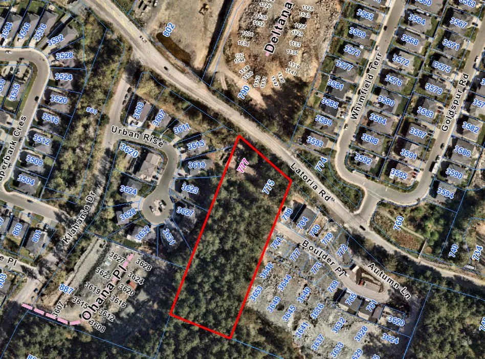
The subject property is located on Latoria Road, between Klahanie Drive and Whimfield Terrace. The two-acre lot is predominately treed, with the existing home located near the front lot line. The lot is quite steep with a 40-meter grade difference between the front and rear of the property. Pritchard Creek is located across from the site on the north side of Latoria Road, meaning the front portion of the property falls within the Riparian Area. The Development Permit Areas and tree clearing required for this site will be discussed later within this report.
The Olympic View lands, which are zoned for a variety of commercial, recreational, and residential uses, abut the southern property boundary of 775 Latoria. It is noted that Olympic View intends to dedicate parkland along their shared property boundary. The new SĆIȺNEW̱ SṮEȽIṮḴEȽ Elementary School is located across the street at 802 Latoria Road.
School District No 62 has been made aware of this application such that they can consider the proposed increase in density in this area as part of their long-range facility planning.

Table 2: Surrounding Land Uses
| Zoning | Use |
|---|---|
| North | R2 (One- and Two-Family Residential) — Duplexes (under construction) |
| East | R2 (One- and Two-Family Residential) — Single Family Homes (under construction) |
| South | CD4 (Comprehensive Development – Olympic View) — Residential and Commercial uses permitted – site under construction. Park space to abut 775 Latoria Road. |
| West | RR7 (Rural Residential 7) — Single Family Homes |
COMMENTARY
Development Proposal
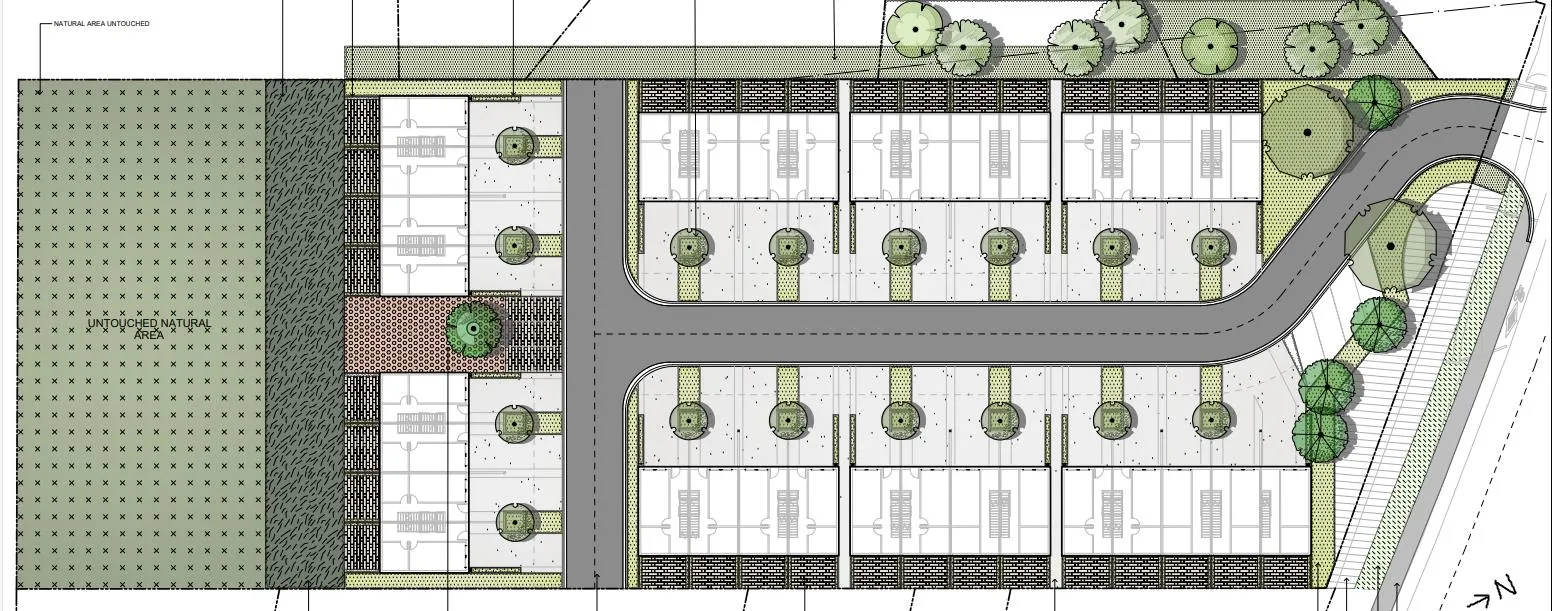
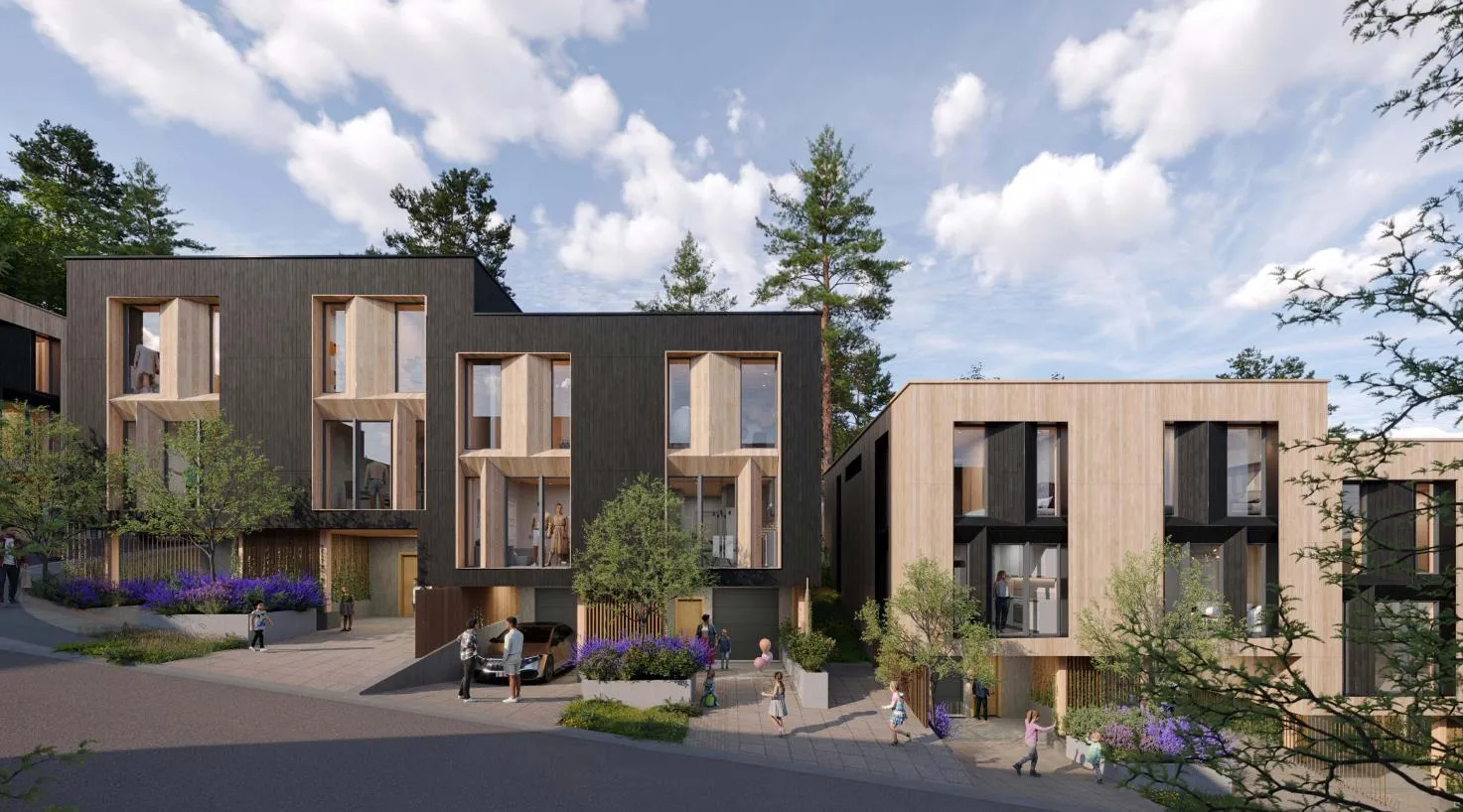
The applicant is seeking to rezone 775 Latoria Road from RR2 (Rural Residential 2) to RT1 (Residential Townhouse 1) to allow for the development of 33 townhouse units with approximately 28% of the lot as a combination of Park dedication and covenanted non-disturbance area. The proposed site plan can be seen below.
The proposed 33 units are intended to each contain 3 bedrooms and a den, making them very suitable for families with multiple children, parents working from home, and other larger household types. Each unit contains two parking spaces, one inside the garage, and another on the driveway. To remain consistent with other developments in Langford, Council may wish to require that the applicant register a Section 219 Covenant on title to require that the garage and carports are used for the parking of vehicles and not the storage of items preventing the parking of vehicles therein. The applicant is also proposing a total of 7 visitor parking spaces, which exceeds the bylaw minimum of 5 visitor spaces.
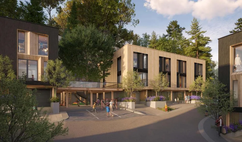
The development has a modern style and has been designed to Step 4 of the BC Building Code. The units are intended to include heat pumps, be solar infrastructure ready, and use long-lasting, low-maintenance exterior materials like composite concrete or metal. Each garage will be EV ready, and the concrete used for the project will comply for the City’s Low Carbon Concrete Policy.
Landscaping
Each unit is designed with a 3.5 m backyard space, exceeding the design guideline suggestion of 3 m, in addition to upper-storey balconies at the rear of the units. The applicant has also designed a unique two-floor common outdoor amenity space at the rear of the site. The ground floor will incorporate accessible playground equipment and a large tree, and stairs leading up to a second storey communal deck that can be used for leisure and gathering.
As mentioned at the beginning of this report, the applicant intends to protect 28% of the lot through a combination of Park dedication and strata common property protected by a non-disturbance covenant.
- Approximately 17.5% of the property (large portion at the rear, dotted green area on the site plan) is to be dedicated to the City as Park. This park area would adjoin a future park dedication area within the Olympic View development, allowing them to run contiguously. The Parks Department has noted that due to the grades, this portion of Park is likely to remain unused for active recreation and would instead be maintained as natural area.
- Abutting the Park dedication area is an 8.5 m wide area that will be retained as part of the strata common property (dashed dark green area). This area represents approximately 5.5% of the land and will sit at the top of a rock face to be protected through a non-disturbance covenant. The intent behind this is for the strata to be in control and responsible for the maintenance of the rock face and trees that could impact their property.
- The applicant also intends to protect an additional 5% of land through a non-disturbance covenant at the front of the property along Latoria Road, as it falls within the Riparian Area of Pritchard Creek. The existing home currently sits in this area, so the applicant intends to restore the area with native plantings.
Council may wish to secure the 28% open space through a Section 219 Covenant, ensuring that at least 17.5% is dedicated to the City as Park.
Trees
As the existing property is predominantly treed, and significant clearing will need to occur to support the development, the applicant has provided an arborist report inclusive of a tree protection plan. The report examined all trees onsite, in addition to 5 m beyond the property boundary to capture any offsite trees that may be impacted by the proposal.
Key findings of the arborist report:
- Approximately 279 trees will need to be removed to support the proposal.
- 21 trees are intended to be topped or modified into habitat trees due to safety concerns.
- 94 trees are intended to be retained.
The arborist has noted that 18 of the 279 trees to be removed are located on neighbouring properties along Urban Rise and will be impacted by the proposed development, rendering them unsafe and required for removal. The arborist has noted that these 18 trees have already been significantly impacted by the blasting, removal of rooting areas, and burial of basal stems which occurred when the Urban Rise development was being constructed. The applicant has approached the impacted neighbours on Urban Rise to discuss the issue and the neighbours have provided their consent to have the trees removed, subject to the applicant re-landscaping and re-grading their lot interfaces, at the developer’s expense. Staff have received consent letters from the four impacted neighbours.
An added complexity is that the 18 trees on the Urban Rise properties predominantly fall within a covenanted non-disturbance area, registered in favour of the City (required by Council in 2016 during the rezoning of the Urban Rise development). Council, by resolution, may wish to offer their consent for the non-disturbance area on Urban Rise to be modified to allow for the tree removal, re-grading, and re-landscaping, subject to the work being done under the supervision of the project biologist. The non-disturbance covenant would remain in place, and the modification and replanting of the covenant area would not allow for additional density for either the Urban Rise or 775 Latoria development.
Council may also wish to secure, through a Section 219 Covenant registered on title, that the Tree Protection Plan outlined in the arborist report is implemented throughout the course of construction.
Table 3: Proposal Data
| Permitted by RR2 (Current Zoning) | Permitted by RT1 (Proposed Zoning) | Proposed by This Application |
|---|---|---|
| Height | 10.5 m 3 storeys |
3 storeys |
| Site Coverage | N/A | 60% |
| Front Yard Setback | 7.5 m | 3 m |
| Interior Side Yard Setback | 3 m | 1.2 m |
| Exterior Side Yard Setback | 3 m | 3.5 m |
| Rear Yard Setback | 10 m | 5.5 m |
| Vehicle Parking Requirement | 2 per unit, plus 1 per suite | 2 per unit |
Multi-Modal Network
FRONTAGE IMPROVEMENTS
The Director of Engineering has noted that full frontage improvements to Bylaw No. 1000 standards will be required, including but not limited to, streetlighting, a 1.5 m wide bike lane, and sidewalk. As this is a family-oriented development, it will be crucial for there to be safe pedestrian access from the development site to the new elementary school across the street. Currently, there is a gap in sidewalk connectivity from this site to either of the crosswalks to the west (Klahanie) or east (Autumn Lane) which provide safe access to the school. As such, Council may wish to require that the applicant be responsible for extending pedestrian access to the east to the crosswalk at Autumn Lane, despite it being beyond typical frontage requirements. Pedestrian access to the Klahanie crosswalk to the west was also considered but determined to be infeasible due to the very narrow shoulder of the road. The applicant has requested that Council allow them to utilize their General Amenity Fund contributions, which will amount to approximately $120,780, to put towards the cost of this sidewalk extension beyond the frontage. If Council wishes to authorize this, they should direct staff to incorporate it into the bylaw.
PEDESTRIAN, CYCLING AND MOTORIST NETWORK
- The site has a single access from Latoria Road, with the new strata road ending in a tee. A fire truck turning template was submitted to ensure the road could accommodate the Langford Ladder Truck.
- Connection to the adjacent Boulder Place or Autumn Lane was not possible as they are both private strata roads; a Traffic Impact Assessment was not required by the Director of Engineering.
- Bike lanes exist along the majority of Latoria Road and the applicant will be responsible for extending the 1.5 m wide bike lane in front of the property.
- The site is within close walking distance of a bus stop in each direction (routes 48 and 52).
Infrastructure
DRAINAGE AND STORMWATER
The applicant has submitted a stormwater technical memo prepared by an engineer outlining how they plan to manage stormwater on-site. This memo has been reviewed and approved by the Director of Engineering.
SEWERS
A sewer main exists along Latoria Road and a connection from the townhomes to this main would be required. Any improvements, extensions, or modifications needed to the sewer main within the municipal road right-of-way will be completed by West Shore Environmental Services at the applicant’s expense.
POTENTIAL NUISANCES
Council may wish to require the applicant to provide a Section 219 Covenant registered on title that provides future landowners with the understanding that a variety of agricultural uses and the South Vancouver Island Rangers gun range are located within close proximity of the site, that these pre-existing uses may result in general nuisances, and that future landowners understand and accept the potential disruption to their residential occupancy of the site.
Construction Impact Mitigation
Council may wish to require a Construction Parking and Delivery Management Plan as a condition of rezoning and require that it be provided to the satisfaction of the Director of Engineering prior to any land alteration. This should be secured within a covenant, prior to Bylaw Adoption.
CONSTRUCTION STAGING/ENCROACHMENTS
Any construction staging beyond the property limits requires a construction licence with the City, including but not limited to temporary above or below ground occupancy of any public lands or rights-of-way. Construction licences must be executed prior to any land alteration and are subject to non-negotiable terms, conditions, and one-time and/or daily fees. All permanent encroachments and above ground temporary construction licences on public lands or rights-of-way are subject to Council approval.
Neighbourhood Consultation
The applicant worked closely with the four owners on Urban Rise that directly abut the western property boundary of 775 Latoria Road to reach a consensus on the interface between their lots and the development site. The applicant also provided notices to neighbours within approximately 100 meters of the site to inform them of the application and provide their contact information to address any concerns.
COUNCIL POLICY
OFFICIAL COMMUNITY PLAN
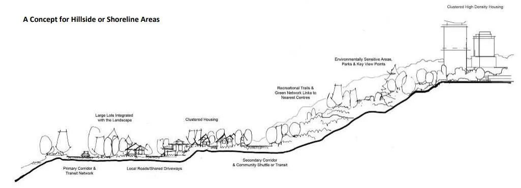
The Official Community Plan (OCP) Bylaw No. 1200 designated the subject properties as “Hillside or Shoreline”, which is defined by the following text:
Predominantly existing low intensity settled areas throughout community with a high percentage of open space and undeveloped areas located on a hillside or near the shoreline.
- Predominantly residential precinct that supports a range of clustered (See Glossary & next page) low, medium and high-density housing choices including secondary suites. Higher building forms, such as point towers, will be permitted on hillsides to maximize open space provided some conditions are satisfied (see policies for this area)
- Schools, community facilities and other institutional uses are permitted throughout the area.
- Home-based businesses, live-work housing is encouraged; Home-based accommodations (e.g. Bed & Breakfasts) are permitted.
- Parks, open spaces and green corridors (creeks, wildlife corridors, trails, etc.) are integrated throughout the area. Large playfields are discouraged due to grading requirements. Site and topographic responsive pocket parks, enhanced viewpoints, graded hiking and walking trails, children’s play areas, including ‘tot lots’ and outdoor exercise areas are strongly encouraged on hillside areas.
- This area allows for Neighbourhood Centres to emerge in the form of high and medium density clustered mixed-use nodes.
- Transit stops are located where appropriate.
In addition to the above objectives, the proposal also meets the following OCP objectives and policies:
- Ensure connectivity of open spaces so as to create a network that supports water flow (i.e. creeks), trails and/or wildlife movement.
- Cluster development on hillside sites to facilitate the protection of all or a significant portion of open space and/or environmentally sensitive areas.
- Lower density development sites such as single detached homes and townhouses shall integrate public and private open space and/or preserved historical or environmentally sensitive features extensively in and around development sites.
- Encourage energy efficiency and green building development for new buildings.
- Promote ‘future-proofing’ of buildings and public works to allow for future adaptability and conversion of energy infrastructure systems.
- Promote walking and cycling in existing areas by developing long term strategies for increasing road, cycle and pedestrian network connectivity.
SOUTH LANGFORD NEIGHBOURHOOD PLAN (SLNP)
The South Langford Neighbourhood Plan designates 775 Latoria Road as Large Lot Residential. This designation is described as the following:
Large Lot Residential: Applies to areas where existing development patterns allow for limited infill development opportunities. A maximum density of 1 lot per 1000 m2 (4 units per acre) is applicable.
The proposed 33 townhomes represent a density of 16.5 units per acre, which significantly exceeds the direction of the South Langford Neighbourhood Plan. Council may wish to note that the South Langford Neighbourhood Plan precedes the City’s Official Community Plan. At the time, the SLNP was retained within the design guidelines as a reference. Council may wish to note that zoning is required to comply with the OCP but is not required to comply with the design guidelines (including the SLNP).
DEVELOPMENT PERMIT AREAS
The subject property falls within the Riparian, Potential Habitat and Biodiversity, High Fire Hazard, and Steep Slopes Development Permit Areas. As such, a development permit will be required prior to any land alteration. As part of the development permit application, the applicant will need to engage multiple professionals including a Registered Professional Biologist, a Registered Professional Forester, and a Geotechnical Engineer. To support their rezoning application, the applicant has already submitted all supporting documentation that will form part of their development permit, should this rezoning be approved. Staff have completed an initial review of the reports, and the results are summarized below.
- Environmental Assessment – Initial findings from the biologist are that there are no Riparian impacts on the property as Pritchard Creek runs on the north side of Latoria Road. The biologist also found that the ecological integrity of the site is considered fair to poor due to the fragmentation that has occurred due to surrounding developments. No species at risk were identified during site visits by the biologist. Staff will have these findings further confirmed prior to the issuance of the development permit.
- Wildfire Hazard Assessment – Confirms that with certain recommendations implemented, the risk of wildfire can be reduced to ensure the safety of the intended residential development.
- Geotechnical Report – Confirms that the proposed grades and cut-slopes for the development are feasible and safe for the intended use in accordance with Bylaw No. 1000 as recently amended by Bylaw No. 1926.
LOW CARBON CONCRETE
In accordance with Council’s Low Carbon Concrete Policy POL-0167-PLAN, Council may wish to require the applicant to utilize ready-mix concrete that meets or exceeds the weighted average Global Warming Potential targets based on Concrete BC Baseline (average) mix data for the construction of the proposed development.
FINANCIAL IMPLICATIONS
Rezoning the subject properties to permit higher density of development will increase the assessed value of lands and eventually will increase municipal revenue due to the number of units created. As the developer is responsible for completing all frontage improvements, the direct capital costs to the City associated with this development will be negligible. A summary of Amenity Contributions and Development Cost Charges that the developer will be expected to pay, is outlined below.
COUNCIL’S AMENITY CONTRIBUTION POLICY
Table 4 – Amenity Contributions per Council Policy (33 units)
| Amenity Item | Per unit contribution | Total (33 units) |
|---|---|---|
| General Amenity Reserve Fund | $3,660 per residential unit | $120,780* |
| Affordable Housing Reserve Fund | $610 per residential unit | $20,130 |
| TOTAL POLICY CONTRIBUTIONS | $140,910 |
*This amount could be put towards the sidewalk extension to Autumn Lane, should Council authorize the use of the funds in this way.
Table 5 - Development Cost Charges
| Development Cost Charge | Per Unit Contribution | Total (33 units) |
|---|---|---|
| Roads | $3,865 | $127,545 |
| Storm Drainage | $1,028 | $33,924 |
| Parks | $2,078 | $68,574 |
| ISIF | $386.25 | $12,746.25 |
| Subtotal (DCC’s to Langford) | $242,789.25 | |
| CRD Water | $2,557 | $84,381 |
| School Site Acquisition | $900 | $29,700 |
| TOTAL DCC’s (estimated) | $356,870.25 |
LEGAL IMPLICATIONS
Should Council choose to proceed with consideration, the application will be prohibited from being the subject of a Public Hearing, as per the changes made by the Province to the Local Government Act through The Housing Statues (Residential Development) Amendment Act, 2023.
The amenity contributions specified in Table 4 above will be incorporated into the bylaw and will be payable at the time of building permit along with the current Development Cost Charges specified in the various DCC Bylaws.
Council’s other conditions of approval would be registered in a Section 219 Covenant in priority of all other charges on title prior to consideration of Bylaw Adoption.
OPTIONS
Option 1
That the Sustainable Development Advisory Committee recommend that Council:
Direct Staff to prepare a bylaw to amend the zoning designation of the properties located at 775 Latoria Drive from RR2 to RT1, subject to the following terms and conditions:
a. That the applicant provides, as a bonus for increased density, the following contributions per dwelling unit, prior to the issuance of a building permit approval:
i. $610 towards the Affordable Housing Reserve Fund; and
ii. $3,660 towards the General Amenity Reserve Fund;b. That the applicant, prior to Bylaw Adoption, registers a Section 219 covenant in priority of all other charges on title, that agrees to the following:
i. That the following will be provided and implemented to Bylaw No. 1000 standards to the satisfaction of the Director of Engineering, prior to the issuance of a building permit:
- Full frontage improvements; and
- A storm water management plan.
ii. That the following will be provided and implemented to Bylaw No. 1000 standards to the satisfaction of the Director of Engineering prior to any land alteration:
- A comprehensive geotechnical plan;
- A construction parking management plan; and
- A mitigation plan.
iii. That a separate covenant be registered prior to the registration of a strata plan for the proposed development agreeing that the garages are to be used for the parking of vehicles and not the storage of items preventing the parking of vehicles therein, in favour of the strata.
iv. That the project shall be constructed with electric heat pumps, to the satisfaction of the Chief Building Inspector;
v. That the project shall be constructed to Step 4 of the BC Building Code, to the satisfaction of the Chief Building Inspector;
vi. That all concrete used on-site will utilize ready-mix concrete that meets or exceeds the weighted average Global Warming Potential targets based on Concrete BC Baseline (average) mix data, and that prior to the issuance of a Building Permit theapplicant shall provide a Type III Environmental Product Declaration that is 3rd party verified specifying the total Global Warming Potential value and confirming that the proposed development meets the requirements of Low Carbon Concrete Policy POL-0167-PLAN;
vii. Acknowledge that the site is in proximity to agricultural uses the South Vancouver Island gun range, and that these uses may create general noise, odour, and other nuisances, and agree that the owner and all future owners assume all risk and annoyance of such nuisances;
viii. That the lot provides at least 28% open space, of which at least 17.5% is dedicated to the City as Park, and the remainder amount is retained as strata common property, to be protected in a non-disturbance covenant, prior to the issuance of a building permit, to the satisfaction of the Director of Parks, Recreation, and Facilities; and
ix. That tree protection measures, inclusive of tree protection fencing, outlined within the arborist report prepared by Capital Tree Service Inc. dated October 27, 2023, are implemented prior to commencement of work on site to protect the trees identified for retention in the arborist report throughout the construction period, to the satisfaction of the Director of Development Services;AND
That Council retains the non-disturbance covenant EPP78535 on Urban Rise, but allows the tree removal, re-grading, and re-landscaping of the areas, subject to the work being supervised by the project biologist, to the satisfaction of the Director of Development Services.
AND
Direct Staff to include within the bylaw an allowance to utilize General Amenity Fund contributions towards the installation of sidewalk beyond the frontage of 775 Latoria Road, connecting to the crosswalk at Autumn Lane, to the satisfaction of the Director of Engineering.
OR Option 2
That the Sustainable Development Advisory Committee recommend that Council take no action with respect to this application to rezone 775 Latoria Road until such time as the following items are addressed and reviewed by the Sustainable Development Advisory Committee:
a. ________________;
b. ________________;
c. ________________;
SUBMITTED BY
Julia Buckingham, Planner II
Concurrence:
Matthew Baldwin, RPP, MCIP, Director of Development Services
Leah Stohmann, RPP, MCIP, Director of Community Planning and Climate Change
Donna Petrie, Senior Manager of Communications & Economic Development
Yari Nielsen, Director of Parks, Recreation and Facilities
Katelyn Balzer, P.Eng., Director of Engineering and Public Works
Michael Dillabaugh, CPA, CA, Director of Finance
Marie Watmough, Director of Legislative & Protective Services
Braden Hutchins, Deputy Chief Administrative Officer
Darren Kiedyk, Chief Administrative Officer
Attachments
- Site Plan
- Landscape Plan
- Arborist Report