DocumentsStaff ReportAug 16, 2021Pages 17–22
Staff Report to Council – Z21-0029 & OCP21-0004 (2981 & 2985 Awsworth Rd)
Planning staff report recommending first reading of Bylaw No. 1896 (OCP amendment) and Bylaw No. 1897 (RR4 text amendment) to allow a truck terminal at 2981 & 2985 Awsworth Rd and outlining site context, ALR considerations and recommended conditions.
Key facts
- Applicant/Owner: Susan Gale Wilson and Todd Edward Wilson
- Property size: 17,080 m2; legal description LOT 1, SECTIONS 99 AND 100, METCHOSIN DISTRICT, PLAN 20923, EXCEPT PARTS
- Recommendation includes requiring Form & Character DP, FUS calculation, SCRF payment, and $5,000 bond for ALR fence
Staff Report to Council
Date: July 19, 2021
Department: Planning
Application No.: Z21-0029 & OCP21-0004
Subject:
Bylaw No. 1896 to Amend the OCP at 2981 & 2985 Awsworth Road from “Hillside or Shoreline” to “Business or Light Industrial”, and Bylaw No. 1897 to amend the text of the RR4 (Rural Residential 4) Zone to allow a Truck Terminal Facility at 2981 & 2985 Awsworth Road.
PURPOSE
Susan Gale Wilson has applied to amend the Official Community Plan (OCP) designation of 2981 & 2985 Awsworth from “Hillside or Shoreline” to “Business or Light Industrial”, and to amend the text of the RR4 (Rural Residential 4) Zone to allow a truck terminal facility. The eastern portion of the property falls within the Agricultural Land Reserve (ALR) which will require that portion of the site to have an OCP amendment to “Agricultural”.
BACKGROUND
Previous applications
The applicant was issued a Temporary Use Permit (TUP) in August of 2020 to operate an existing truck terminal facility for a period of 3 years. While their current TUP does not expire until August of 2023, the applicant wishes to formalize the use through a text amendment rezoning.
Table 1: Site Data
| Field | Information |
|---|---|
| Applicant & Owner | Susan Gale Wilson and Todd Edward Wilson |
| Civic Address | 2981 & 2985 Awsworth Road |
| Legal Description | LOT 1, SECTIONS 99 AND 100, METCHOSIN DISTRICT, PLAN 20923, EXCEPT THAT PART IN PLAN 51055 AND VIP75263 |
| Size of Property | 17,080 m2 |
| DP Areas | Habitat and Biodiversity, 200 Year Flood Plain |
| Zoning Designation | RR4 (Rural Residential 4) |
| OCP Designation | Hillside or Shoreline |
Site and Surrounding Area
The existing property is located near the southwestern boundary of the City of Langford. The property is surrounded by predominately vacant rural residentially zoned properties and properties designated within the Agricultural Land Reserve (ALR). Approximately one third of the property is included in the ALR (denoted by the spotted orange map overlay) and zoned AG1 (Agriculture 1). Given this, only uses permitted by the Agricultural Land Commission may occur on this portion of the lot. The remaining portions of the property consist of a steep rocky outcrop on the western side, with a flat, at grade portion in the centre. There is a single family home located on the lot that is currently rented out.
The existing Sooke Road West and Centre Mountain Business Parks are located nearby to the east and west of the property.
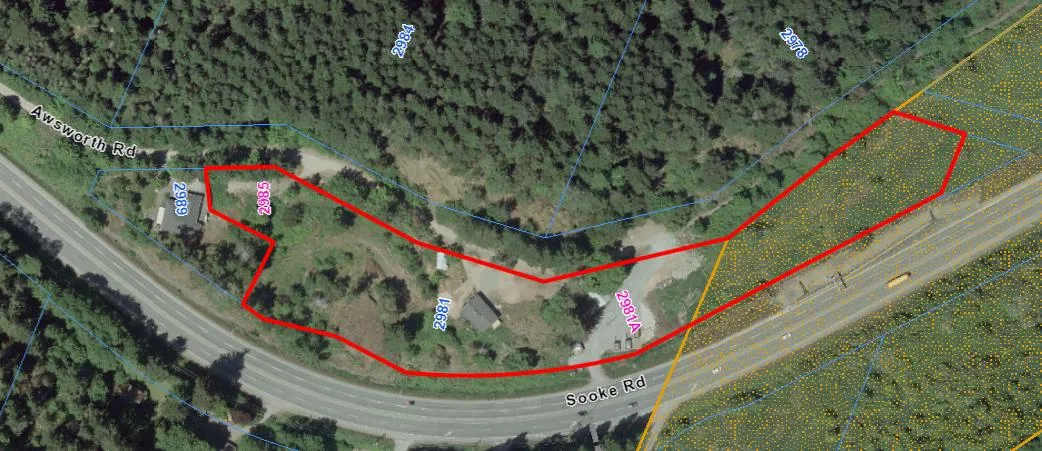
Table 2: Surrounding Land Uses
| Zoning | Use |
|---|---|
| North | RR4 (Rural Residential 4) — Currently vacant |
| East | AG1 (Agriculture 1) — Currently vacant – Agricultural Land Reserve |
| South | RR4 (Rural Residential 4) — Single Family Dwellings |
| West | RR4 (Rural Residential 4) / BP8 (Business Park 8 – Centre Mountain) — Currently vacant with the exception of a wood cutting business |
COMMENTS
OFFICIAL COMMUNITY PLAN (OCP)
The current OCP designation of the subject property is Hillside or Shoreline which allows for residential and institutional uses and capitalizes on the shoreline access and sloping features of the topography.
As the applicant wishes to rezone the site for the purpose of running a truck terminal facility, an OCP amendment will be required from the Hillside or Shoreline policy designation to the Business or Light Industrial designation. It would not be appropriate to amend the portion of the site that is in the ALR to Business or Light Industrial as those lands are controlled by the Agricultural Land Commission. Council may wish to amend the OCP of this portion of the site from Hillside or Shoreline to Agricultural as most other lands within the ALR fall within this land use designation of the OCP.
The Business and Light Industrial designation is an appropriate OCP designation for the remainder of the site as it is consistent with the applicant’s intent to operate a truck terminal facility. As the applicants only intend to formalize this particular use, they are proposing to amend the text of the RR4 zone rather than rezoning to a Business Park Zone that would also allow a full range of business park uses.
Council may wish to note that all the lands across from this site, south of Sooke Road/Highway 14, are designated as Business or Light Industrial.
The OCP contains the following Policies and Objectives for lands designated as Business or Light Industrial Centre:
- Predominantly business and light industrial precinct that supports a range of business uses
- Parks, open spaces are integrated throughout the centre where appropriate to serve users and employees and green corridors (creeks, wildlife corridors, trails, etc.) that connect to other parts of the community where appropriate.
- Transit stops are located where appropriate
A Concept for Business or Light Industrial Centre:
DEVELOPMENT PERMIT AREAS
The subject property has been identified as being within two Environmental Protection Development Permit Areas, the Potential Habitat and Biodiversity Area and the 200 Year Flood Plain. Any land alteration on the subject property will require a Development Permit to be applied for and issued by the Director of Planning. Although the property would still be within the RR4 zone, Council may wish to require a form and character development permit as the property will be used for a truck terminal facility which is typically categorized as a light industrial use.
DEVELOPMENT PROPOSAL
The owners of the subject property have been operating a small scale trucking business on the property as well as renting out the existing single family dwelling. The owners currently have a Temporary Use Permit to allow these uses that expires in August of 2023. In order to continue these uses past 2023, the property requires rezoning. At this time, the owners do not wish to rezone to allow a full range of business park uses. As such, a text amendment to the current RR4 Zone to allow a truck terminal facility is proposed.
Council should note that only the western portion of the site currently zoned RR4 will be subject to the text amendment rezoning, and the ALR portion would remain in the AG1 (Agriculture 1) Zone where the business would not be permitted to operate. Council may wish to require that the applicant construct a fence delineating the ALR portion from the remainder of the property to ensure there are no encroachments from the truck terminal facility.
As part of the owner’s application for a TUP in 2020, they provided the City with an Edge Plan from an Agrologist speaking to the risks and mitigating factors required for the trucking business to operate adjacent to ALR land. The Agrologist has stated that for the proposed use, an ALR Edge Plan will only need to be implemented if the ALR land within the property boundary is used for farming purposes. Currently, the ALR portion of the property is not being farmed. When Council considered the TUP, they required that the applicant register a Section 219 Covenant that secured the implementation of any and all recommendations regarding proximity to the Agricultural Land Reserve as per the Edge Plan prepared by C&F Land Resource Consultants dated April 17, 2020. As this has already been registered on title, Council does not need to secure it again through this rezoning.
Should the owner or any future owners wish to use the site for any other business park or light industrial uses, another rezoning application would be required. If this occurs, Council would likely want to request a Traffic Impact Assessment, updated Agrologist report, among other items depending on the specific proposal.
PEDESTRIAN, CYCLING AND MOTORIST NETWORK
Council may wish to note that through the issuance of the TUP in 2020, the City required the owners to permanently close the direct vehicular access from the site onto Sooke Rd/Highway 14. Vehicular access to and from the site now occurs via Awsworth Road. It should be noted that there is no traffic light located at the intersection of Awsworth Road and Sooke Road/Highway 14 but a left-hand turn onto Sooke Road/Highway 14 is permitted.
INFRASTRUCTURE
This property is not currently serviced by the municipal sewer system or connected to CRD Water. As the property falls within the City of Langford Sewer Contract Area, the applicant will be required to complete the following before the issuance of a building permit:
a) The owner grants to the City a covenant under s.219 of the Land Title Act that requires the owner to connect the building to the municipal sanitary sewer system within 6 months of a sewer main being installed in a highway or City statutory right of way abutting the parcel on which the building is located.
b) Payment of the Sewer Capital Recovery Fee (SCRF) to West Shore Environmental Services or the City of Langford is made prior to the issuance of a building permit authorizing the construction of the building.
c) Installation of all on-site plumbing necessary between the building and a point 1.0 m from the boundary of the highway or statutory right of way that the City designates as the future location of the sewer, to allow the building to be connected to the municipal sanitary sewer system in accordance with the BC Building Code, and the works are installed in accordance with the permit prior to occupancy of the building. The City may require the owner to install works for either a 100mm diameter gravity connection or a 50mm diameter force main connection.
As the property is not connected to the municipal water system, the owner will need to submit a Fire Underwriters Survey (FUS) calculation to determine the waterflows at the site prior to the issuance of a Building Permit. Sprinklers or other interventions may be required based on the results of the calculation.
FINANCIAL CONTRIBUTIONS
Development Cost Charges will apply as per Bylaw No. 1700 should the owners construct any buildings on site for the purpose of the trucking business.
OPTIONS
That Council:
Consider proceeding with First Reading of Bylaw No. 1896 to amend the Official Community Plan designation of the property at 2981 and 2985 Awsworth Road from “Hillside or Shoreline” to “Business Park or Light Industrial” and “Agricultural”
Consider proceeding with First Reading of Bylaw No. 1897 to amend the text of the RR4 zone to allow a truck terminal facility on 2981 and 2985 Awsworth Road subject to the following conditions:
a. That prior to Public Hearing, a stormwater technical memo shall be submitted and approved to the satisfaction of the Director of Engineering;
b. That prior to Bylaw Adoption, the applicant registers a Section 219 Covenent, in priority of all other charges on title that agrees to complete the following prior to the issuance of a building permit: i. That a stormwater management plan shall be submitted and implemented to the satisfaction of the Director of Engineering; ii. That a Fire Underwriters Survey (FUS) calculation shall be submitted to determine sufficient waterflow to the satisfaction of the Chief Building Inspector; iii. That the owner connect the building to the municipal sanitary sewer system within 6 months of a sewer main being installed in a highway or City statutory right of way abutting the parcel on which the building is located; iv. That payment of the Sewer Capital Recovery Fee (SCRF) to West Shore Environmental Services or the City of Langford is made; v. That installation of all on-site plumbing necessary between the building and a point 1.0 m from the boundary of the highway or statutory right of way that the City designates as the future location of the sewer, to allow the building to be connected to the municipal sanitary sewer system in accordance with the BC Building Code, and the works are installed in accordance with the permit prior to occupancy of the building. The City may require the owner to install works for either a 100mm diameter gravity connection or a 50mm diameter force main connection vi. That the applicant be required to apply for a Form and Character Development Permit for any buildings constructed on site that relate to the business use;
c. That prior to the Bylaw Adoption, the applicant shall provide a $5,000 bond for the construction of a fence along the boundary of the RR4 and AG1 zone to delineate the land within the Agricultural Land Reserve to the satisfaction of the Director of Planning;
- Take no action at this time with respect to Bylaw No. 1896 and 1897.
Respectfully Submitted,
Submitted by:
Julia Buckingham, Planner II - Approved
Concurrence:
Marie Watmough, Manager of Legislative Services - Approved
Chris Aubrey, Fire Chief - Approved
Ivan Leung, Acting/Director of Engineering - Approved
Leah Stohmann, MCIP, RPP, Deputy Director of Planning - Approved
Michael Dillabaugh, CPA, CA, Director of Finance - Approved
Braden Hutchins, Director of Corporate Services - Approved
Darren Kiedyk, Chief Administrative Officer - Approved
:jb