Planning staff report proposing rezoning of multiple parcels at 1100 McCallum Rd and 2780 Spencer Rd to a new Mixed-Use Employment 3 (MUE3) zone to allow residential, multi-family and commercial development, with recommended conditions and infrastructure requirements.
Staff Report (Planning) – Application to Rezone 1100 McCallum Road and 2780 Spencer Road (Z19-0029)
Date: February 10, 2020 Department: Planning Application No.: Z19-0029
Page 17–30
PURPOSE
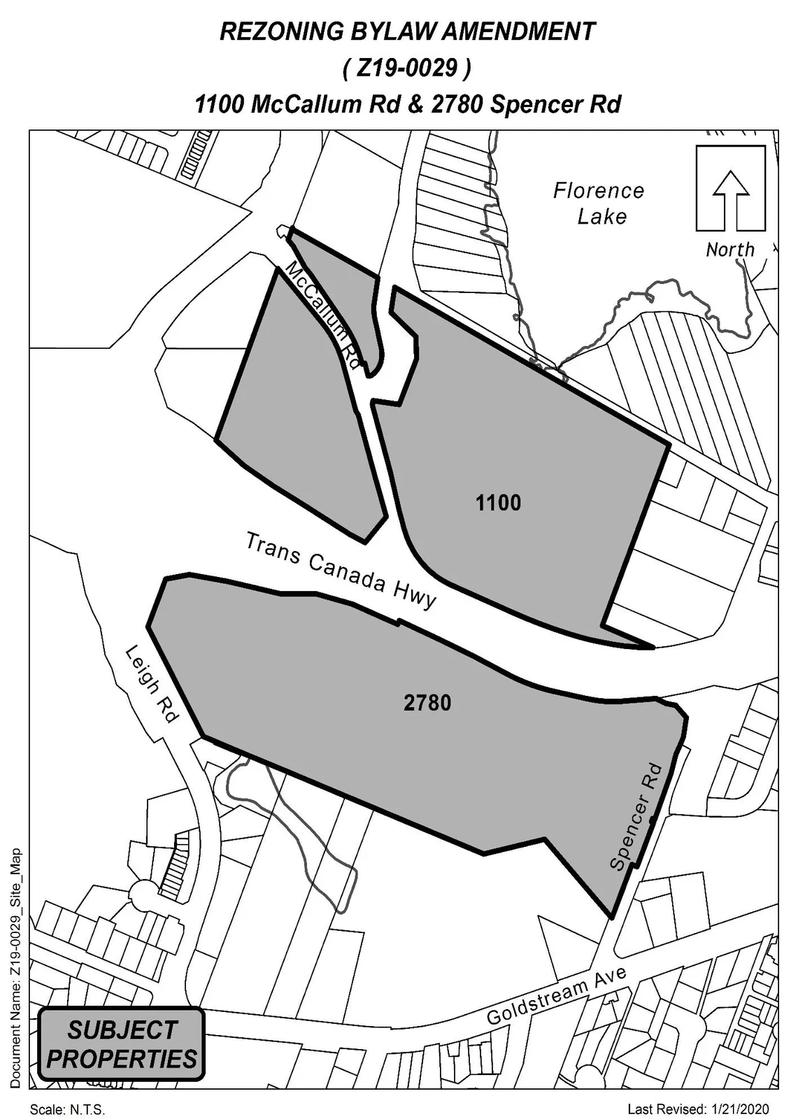
Niall Paltiel of Keycorp Consulting Ltd. has applied on behalf of Leanne Kramer to rezone 1100 McCallum Road and 2780 Spencer Road from One- and Two-Family Residential (R2), Rural Residential (RR4), Mobile Home Park (RH1), Tourist Commercial – Motel (CT1), and Comprehensive Development – South Skirt Mountain (CD12) to a new Mixed-Use Employment 3 (MUE3) zone. This would allow for the future development of these lands to residential, multi-family, and commercial uses.
Page 17–30
BACKGROUND
Previous Applications
In the northwest corner of the land north of the Trans-Canada Highway, approximately 4,200m² (1.0 acre) had previously been rezoned to CD12 (Comprehensive Development - South Skirt Mountain). The City also received a rezoning application for all the lands north of the Highway in 2005 (Z05-0001) which was taken as far as public hearing, but that application expired and never received adoption.
Table 1: Site Data
Item
Details
Applicant
Niall Paltiel, Keycorp Consulting Ltd.
Owner
Leanne Kramer
Civic Addresses
1100 McCallum Road and 2780 Spencer Road
PIDs
029-006-361 and 004-333-233
Size of Properties
20 hectares (50 acres)
DP Areas
Fire Hazard, 200 Year Flood Plain, Drainage Concern, Potential Habitat and Biodiversity, Riparian Areas, Steep Slopes, Wetland, and Woodland
Page 17–30
Zoning and OCP
Item
Existing
Proposed
Zoning Designation
R2, RR4, RH1, CT1, CD12
Mixed-Use Employment 3 (MUE3)
OCP Designation
Mixed Use Employment Centre
Mixed Use Employment Centre
Page 17–30
SITE AND SURROUNDING AREA
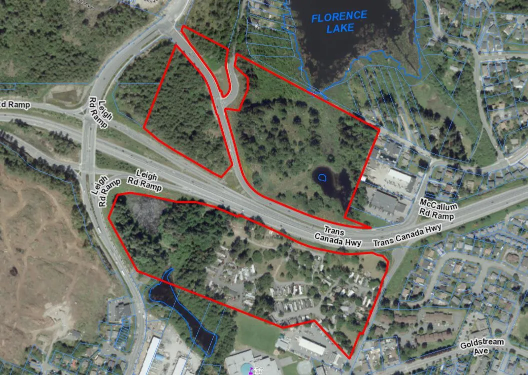
The properties north of the Trans Canada Highway are vacant and treed. There is an area immediately south of Florence Lake that lacks trees due to the fact that this area is wet and is located within several environmental DP areas.
For the property south of the Trans Canada Highway, the eastern portion is used as a mobile home park for 78 mobile homes. The western portion is primarily treed and is located within several environmental DP areas.
Table 2: Surrounding Land Uses
Direction
Zoning
Use
North
R2 (One- and Two-Family Residential); RR4 (Rural Residential 4)
Residential; Residential
East
R2 (One- and Two-Family Residential); RM2 (Attached Housing); RM7A (Medium Density Apartment A); MU1A (Mixed Use Residential Commercial A); BP5 (Business Park 5 – McCallum Rd South); C3 (District Commercial); CS1 (Tourist Commercial – Motel)
Residential; Attached Dwellings; Attached Dwellings; Multi-Family Residential; Construction Yard; Offices and Service Station; Offices
South
R2 (One- and Two-Family Residential); RR4 (Rural Residential 4); BT1 (Business and Technology Park); P2 (Community Institutional)
Vacant; Vacant; Vacant; Middle School
West
MUE1 (Mixed Use Employment 1); CD12 (Comprehensive Development – South Skirt Mountain)
Vacant; Residential
Page 17–30
Figure 1 – Subject Properties
Page 17–30
COUNCIL POLICY
OFFICIAL COMMUNITY PLAN
The Official Community Plan (OCP) Bylaw No. 1200 designates the subject property as ‘Mixed Use Employment Centre’, which is defined by the following text:
A predominantly workplace precinct that includes business of all types including commercial, light industrial, and institutional.
An ideal location for creative or innovative infill housing (such as artisan live-work, mixed use buildings, etc.) that does not jeopardize the long-term function of the centre as an employment node.
Parks, public squares and open spaces are integrated throughout.
Centre is an inter-city and/or inter-regional transit hub that connects residents and employees.
Page 17–30
DEVELOPMENT PERMIT AREAS
Collectively, the subject properties are located within most of the environmental and hazard Development Permit areas. These DP areas include the following: Fire Hazard, 200 Year Flood Plain, Drainage Concern, Potential Habitat and Biodiversity, Riparian Areas, Steep Slopes, Wetland, and Woodland.
These various DP areas are required to be examined by a qualified professional, who will then submit a report outlining recommendations from their examination. Subsequent Development Permit(s) will need to be issued prior to any works occurring on site. Given the proposal, a Form and Character DP will be required for future proposed buildings, which will comply with the City’s Design Guidelines.
Page 17–30
COMMENTS
DEVELOPMENT PROPOSAL
Details of a future build out and specific uses are not known at this time. However, there are some aspects of the larger picture that are known. The lands on the north side of the highway are considered to be a greenfield site. As such, the applicant has determined where some environmentally sensitive lands are located and is proposing to dedicate approximately 4 hectares (10 acres) of land to the City. Additional land may be dedicated in the future depending on what is determined through the environmental Development Permits.
With respect to the land on the south side of the highway, the mobile home park will remain as-is until Council approves a compensation plan for home owners that are relocated, as per Council’s Manufactured Home Park Relocation Policy. Council may wish to secure this item in a covenant.
AREA OF ARCHAEOLOGICAL SIGNIFICANCE
In May of 2000 the City received a report that identifies a midden on the subject property. A midden is a mound of domestic refuse containing shells and animal bones marking the site of a prehistoric settlement. The report states ‘under current government regulations, it would require a qualified archaeologist to assess the site should development in this area be contemplated’. Council may wish to have a covenant registered to require a qualified archaeologist to assess the site, prior to site disturbance, and have the applicant complete the recommendations of the archeologist’s report as a condition of development.
Table 3: Proposal Data
Permitted by R2 and RH1 (Current Majority Zoning)
Proposed by MUE3 Zone — Permitted Uses
• One- or Two-Family Dwelling • Manufactured Homes • Group Daycare
• Townhomes • Apartments • Hotel • Parking Facility • Restaurants • Retail Stores • Public Transportation Depot • Automotive Sales and Service • Gasoline Service Station • Recreational Facility • Offices
Development Standards Comparison
Item
R2 / RH1
Proposed MUE3
Density
550m² lots
6.0 FAR
Height
9m (30 ft)
N/A
Site Coverage
35%
N/A
Front Yard Setback
6m (20 ft)
5.5m (townhouse); 2.0m (commercial/multi-family)
Interior Side Yard Setback
1.5m (5 ft)
1.5m (townhouse); 6.0m (commercial next to residential)
Exterior Side Yard Setback
4.5m (15 Ft)
3.5m (townhouse); 2.0m (commercial/multi-family)
Rear Yard Setback
6m (20 ft)
5.5m (townhouse); 2.0m (commercial/multi-family)
Parking Requirement
2 per dwelling
As per Part 4 of bylaw 300
NEW MUE3 ZONE SPECIFICATIONS
A proposed new MUE3 Zone has been drafted, based on the MUE1 (Mixed-Use Employment) zone, which applies to the large parcel of land located southwest of the Leigh Road interchange. The main difference between these two zones would be the allowable density and amenity contributions as outlined in the proposed zone specifications attached as Appendix C.
This new zone would allow for a range and mix of uses and densities that has the potential to create an area that could be used for work, commercial/retail, recreational facilities, and residential living.
FRONTAGE IMPROVEMENTS
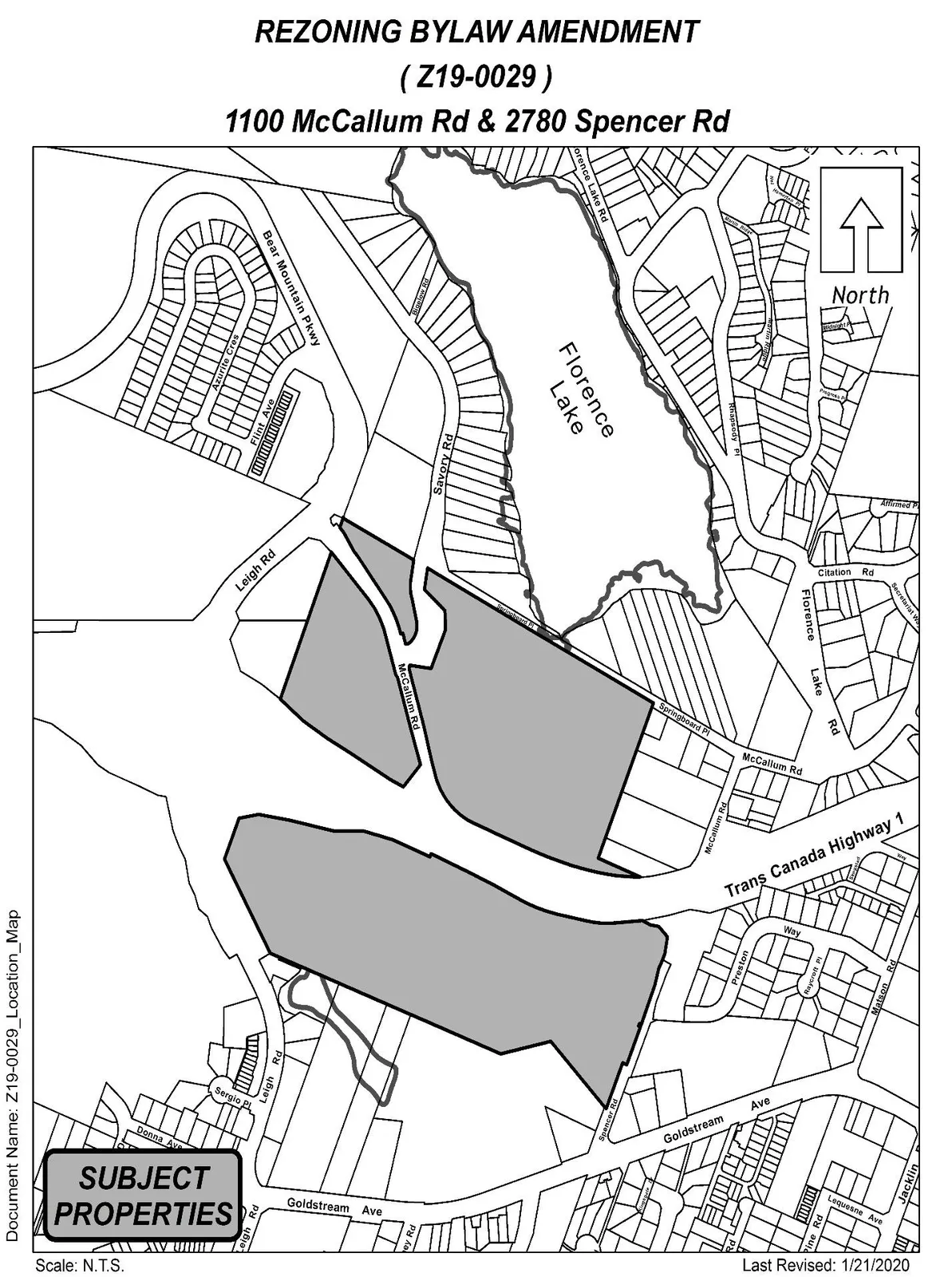
The subject properties front several municipal roads, the Trans-Canada Highway, and on- and off-ramps to the Highway. The Ministry owned highway and ramps would not require any improvements. Roads that front these properties are listed below along with expected improvements, if any.
McCallum Road The applicant will be required to provide full frontage improvements in accordance with Bylaw 1000, as a condition of building permit, or prior to subdivision. Many road improvements have been completed, but some items are still needed such as bike lanes on both sides of the road and street lighting. A right of way for access through 1121 McCallum to 2681 Leigh Road as per the ultimate road plans will need to be registered. This right of way should connect to McCallum directly opposite Savory Road.
Spencer Road Road dedication and improvements may be required, which will be determined by the Director of Engineering. A sidewalk along the west side of Spencer Road is to be installed and connected with the existing sidewalk at 2788 Spencer. Street lights may also be required depending on existing spacing.
Springboard Place Road dedication and improvements that include a turn around will be required. Any additional improvements will be determined by the Director of Engineering.
New Roads If any new roads are proposed, they would need to be built to Bylaw 1000 standards to the satisfaction of the Director of Engineering.
SEWERS
Sewer mains exist along the frontage of all the properties within this development. Any improvements or modifications needed to the sewer mains within the municipal road right-of-way will be constructed by West Shore Environmental Services at the applicant’s expense.
DRAINAGE AND STORMWATER MANAGEMENT
As the site develops over time, an engineer of record would need to submit a detailed stormwater management plan, to the satisfaction of the Director of Engineering outlining how stormwater will be managed onsite. However, as a condition of rezoning, Council may wish to request the applicant to provide a preliminary technical memo from an engineer in this regard to the satisfaction of the Director of Engineering.
NEIGHBOURHOOD CONSULTATION
The applicant has discussed this proposal with residents of the mobile home park. The results of those discussions have been to allow for an overall reduced size of the mobile home park with the majority of mobile homes remaining. Any resident that decides to not stay shall be compensated as per Council Manufactured Home Park Redevelopment Policy. The future development of the manufactured home park could occur, but not until Council agrees to a relocation compensation package for residents as per Council’s policy. Council may wish to secure this requirement through the registration of a restrictive covenant in this regard.
VEHICLE ACCESS AND ROAD NETWORK
The applicant is requesting that the City rezone these properties before a detailed development plan or a road network plan is finalized, which are based on higher densities then what was previously considered for this site.
Council may wish to request the applicant provide a Transportation Impact Assessment (TIA) given how much traffic this development could generate. From the TIA, any recommended road network improvements necessary to accommodate increased density would be implemented by the applicant, which may include signalization of a new intersection on Leigh Road south of the Leigh Road overpass and north of Goldstream Avenue. The TIA and recommended improvements would be to the satisfaction of the Director of Engineering and due prior to the issuance of a master plan development permit. Details of internal roads onsite would also need to be presented prior to issuance of a master plan development permit in order to plan appropriately for future traffic flows through the site and to other access points.
Page 17–30
AMENITY CONTRIBUTIONS
Given the size of this site and the potential density that could be achieved, it’s possible that amenity contributions on this development could range between $2,500,000–$4,000,000 based on Council’s current policy. However, without knowing how this site will develop, Council may wish to simply require amenity contributions as a lump sum as opposed to a per unit contribution, which was how amenity contributions were requested on the Belmont site.
In determining alternative amenity contributions that would be similar in value to the potential amenity contributions as noted above, the following may be considered to make up this value:
The 4 hectares (10 acres) that is being dedicated to the City. This land contains environmental elements and protected areas which should not be built upon as they are important due to its contribution to the surrounding ecosystem.
The portion of McCallum Road that runs through this site and connects to Bear Mountain Parkway was dedicated and built several years ago. This was completed prior to any rezoning or development occurring on these lands and positively contributes to the alleviating congestion in the nearby road networks.
The land where the on and off ramps between Leigh Road and the Trans-Canada Highway were previously dedicated to allow for the construction of the overpass.
The owner has for multiple years now, prior to any development, financially contributed towards the Leigh Road Interchange through a Local Servicing Agreement.
The applicant is proposing to construct a 1,000 square foot amenity building on the mobile home site for those residents.
Residents of the mobile home park that are relocated elsewhere will be compensated as per Council’s Manufactured Home Park Redevelopment Policy.
The mobile home park would continue to be operated as a mobile home park.
The collective result of these contributions may be considered to have comparable value of what would otherwise be collected on a per unit basis at the building permit stage.
Page 17–30
FINANCIAL IMPLICATIONS
Rezoning the subject property to permit a higher density of development will increase the assessed value of lands and increase municipal revenue due to the number of units created. As the developer must complete all frontage improvements, the direct capital costs to the City associated with this development will be negligible. A summary of Amenity Contributions and Development Cost Charges that the developer will be expected to pay, is outlined in Tables 4 and 5 below.
Table 4 – Amenity Contributions
Amenity Item
A minimum 4 hectares (10 acres) land dedication.
The dedication of land for road improvements that have already taken place.
93m² (1,000 ft²) amenity building.
The continued operation of the mobile home park.
Compensation to residents of the manufactured home park that are relocated.
Table 5 – Development Cost Charges
Development Cost Charge
Per unit / area contribution
Total
Roads
$3,188 (multi-family) $55.78 (commercial m²)
TBD
Park Improvement
$1,890 (multi-family)
TBD
Park Acquisition
$1,100 (multi-family)
TBD
Incremental Storage Improvement Fees
$331.65 (multi-family) $140/1000ft² (commercial)
TBD
Integrated Survey Area
$35 per lot
TBD
Subtotal (DCCs paid to City of Langford)
TBD
CRD Water
$2,557 (multi-family) $10.74/m² (commercial)
TBD
School Site Acquisition
$600 (multi-family)
TBD
TOTAL (estimate) DCCs
TBD
Page 17–30
OPTIONS
Option 1
That the Planning, Zoning and Affordable Housing Committee recommend that Council:
Proceed with consideration of Bylaw No. 1885 to amend the zoning designation of the property located at 1100 McCallum Road and 2780 Spencer Road from R2 (One- and Two- Family Residential), CD12 (Comprehensive Development – South Skirt Mountain), RR4 (Rural Residential 4), RH1 (Mobile Home Park), and CT1 (Tourist Commercial – Motel) to a new MUE3 (Mixed-Use Employment 3) Zone subject to the following terms and conditions:
a) That the applicant provides, as a bonus for increased density, the following contribution prior to issuance of a building permit or subdivision approval:
i. The dedication to the City of at least 4.0 hectares of land in a form and location to the satisfaction of the Director of Planning; and
ii. The dedication to the City, or the registration of a non-disturbance covenant, of any additional lands that a qualified professional determines should be protected as per their analysis of the development permit areas; and
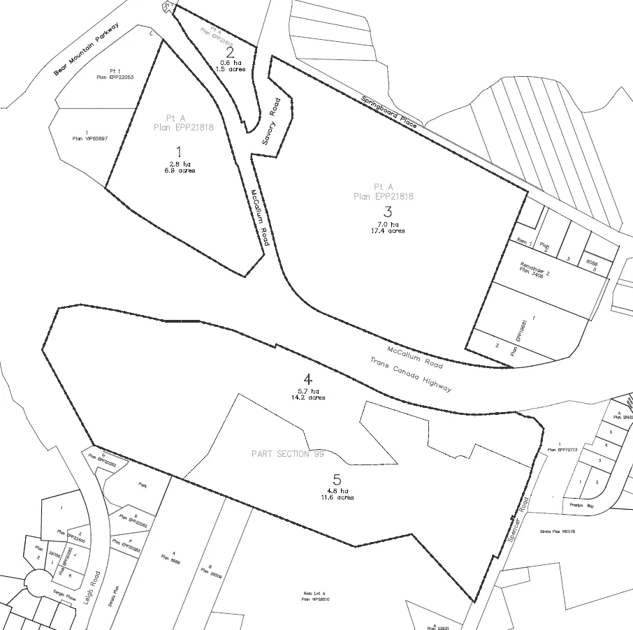
iii. The construction of an 93m² (1,000 ft²) amenity building within Area 5 shown in Appendix A for the use of the residents of the mobile home park to the satisfaction of the Director of Planning.
b) That the applicant provides, prior to Public Hearing, the following:
i. A technical memo from an engineer that verifies storm water can be adequately managed on-site for the proposed development, to the satisfaction of the Director of Engineering.
c) That the applicant provides, prior to Bylaw Adoption, a Section 219 covenant, registered in priority of all other charges on title, that agrees to the following:
i. That an overall mixed use concept plan implementing the objectives of the Mixed-Use Employment Centre OCP designation for each area identified in Appendix A be provided to the satisfaction of the Director of Planning prior to issuance of a Form and Character Development Permit for that area; and
ii. That a no-build and non-disturbance covenant be registered on Area 5 identified in Appendix A that restricts the use to a mobile home park only until the mobile home residents and Council approves a compensation plan for home owners per Council’s Manufactured Home Park Redevelopment Policy; and
iii. That a qualified archaeologist assess the site prior to any site disturbance, and that the applicant complete the recommendations of the archeologist’s report as a condition of development; and
iv. That all road dedication of new roads and/or widening of existing roads is provided prior to issuance of a building permit or subdivision approval, whichever is first, to the satisfaction of the Director of Engineering and Approving Officer; and
v. That a Traffic Impact Assessment (TIA) be completed prior to issuance of a master plan development permit to the satisfaction of the Director of Engineering for the proposed development, and that the recommendations of the TIA be implemented; and
vi. That a Statutory Right of Way be provided on 1121 McCallum Road (identified as Area 1 on Appendix A) for access to lands to the west prior to issuance of a building permit or subdivision approval, whichever is first; and
vii. That all frontage improvements to Bylaw 1000 standards are provided prior to issuance of a building permit or subdivision approval, whichever is first, to the satisfaction of the Director of Engineering;
viii. That a storm water management plan be provided prior to issuance of a building permit or subdivision approval, whichever is first, and implemented as per Bylaw 1000, all to the satisfaction of the Director of Engineering; and
ix. That the required parking stalls for this development are allocated for the use by individuals in each unit, as required by Bylaw 300 and designed accordingly, and that parking stalls are not rented out individually;
OR Option 2
Take no action at this time with respect to Bylaw No. 1885.
Page 17–30
Submitted by:
Robert Dykstra, MCIP, RPP Land Development Planner
Concurrence: Matthew Baldwin, MCIP, RPP, Director of Planning Adriana Proton, Manager of Legislative Services Chris Aubrey, Fire Chief Cory Manton, Manager of Parks and Recreation Michelle Mahovlich, P.Eng, P.Geo, Director of Engineering Leah Stohmann, MCIP, RPP, Deputy Director of Planning Michael Dillabaugh, CPA, CA, Director of Finance Braden Hutchins, Director of Corporate Services Darren Kiedyk, Chief Administrative Officer
Appendix A - Proposed Block LayoutAppendix B - Subject PropertiesAppendix C - Location Map