DocumentsStaff ReportDec 2, 2019Pages 47–52
Staff Report — Bylaw No. 1870 / Application to Rezone 894 Walfred Road (Z19-0006)
Planning staff report recommending rezoning of 894 Walfred Road from R1 to RS4 to enable creation of approximately 14 small lots with suites, including analysis of OCP, servicing, variances, neighbourhood consultation, and financial contributions.
Key facts
- Applicant: Rachael Sansom; Owner: Tracey Johnson; Civic address: 894 Walfred Road; Site size: 0.9 hectares (2.3 acres)
- Proposal: Rezone to RS4 to allow ~14 new small lots (min. 400 m2) with suites; existing house to remain
- Requested variances for existing dwelling: exterior side yard setback from 3.5m to 2.9m; rear yard setback from 5.5m to 3.0m
- Amenity contributions per Council policy: $660 per lot (Affordable Housing) = $9,240 total; $3,960 per lot (General Amenity) = $55,440 total; total $64,680
- Estimated DCCs (City of Langford subtotal): Roads $6,056/lot, Storm Drainage $1,878/lot, etc.; subtotal (DCCs to City) shown as $160,356
Staff Report — Bylaw No. 1870 - Application to Rezone 894 Walfred Road (Z19-0006)
Date: October 15, 2019
Department: Planning
Application No.: Z19-0006
Subject
Bylaw No. 1870 - Application to Rezone 894 Walfred Road from One-Family Residential (R1) to Residential Small Lot 4 (RS4) to Allow Single-Family Dwellings with Suites on Small Lots
PURPOSE
Rachael Sansom has applied on behalf of Tracey Johnson to rezone 894 Walfred Road from One-Family Residential (R1) to Residential Small Lot 4 (RS4) to allow for 14 new lots with a minimum size of 400m² (4,300 ft²) for single-family dwellings with suites.
BACKGROUND
PREVIOUS APPLICATIONS
Table 1 below outlines the relevant land use applications that have previously been received.
Table 1: Land Use Applications
| Type | File No. | Description |
|---|---|---|
| Rezoning | Z08-0019 | GR2 to R4 for eight new lots. |
| Rezoning | Z12-0044 | R4 to R1 for twelve new lots. |
| Subdivision | SUB08-0028 | To create 8 new lots. |
| Subdivision | SUB11-0012 | To create 8 new lots. |
| Subdivision | SUB13-0012 | To create 12 new lots. |
| Subdivision | SUB14-0046 | To create 12 new lots. |
SITE AND SURROUNDING AREA
The subject property is located on the north side of that section off Walfred Road in between Jacklin Road and Cuaulta Crescent. The neighbouring properties are large in size, typically over 0.8 hectares (2 acres), and contain single family homes. These lots are primarily treed.
Table 2: Site Data
| Applicant | Rachael Sansom |
|---|---|
| Owner | Tracey Johnson |
| Civic Address | 894 Walfred Road |
| Legal Description | Lot 3, Section 78, Esquimalt District, Plan 22056 |
| Size of Property | 0.9 hectares (2.3 acres) |
| DP Areas | Interface Fire Hazard, Potential Wildlife Habitat and Biodiversity |
| Zoning Designation | Existing: One-Family Residential (R1) Proposed: Residential Small Lot 4 (RS4) |
| OCP Designation | Existing: Hillside or Shoreline Proposed: Hillside or Shoreline |
Table 3: Surrounding Land Uses
| Direction | Zoning | Use |
|---|---|---|
| North | Rural Residential (RR1) | Residential |
| East | Rural Residential 5 (RR5) | Residential |
| South | Rural Residential 5 (RR5) | Residential |
| West | Rural Residential 5 (RR5) | Residential |
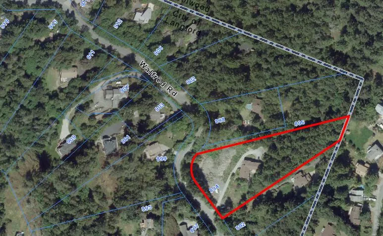
Figure 1 – Subject Property
COUNCIL POLICY
Official Community Plan
The subject property is located within the Hillside or Shoreline OCP designation, which is defined by the following text:
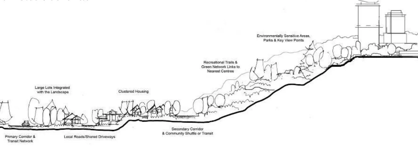
- Predominantly residential precinct that supports a range of clustered low, medium and high density housing choices including secondary suites. Higher building forms, such as point towers, will be permitted on hillsides to maximize open space provided some conditions are satisfied
- Schools, community facilities and other institutional uses are permitted throughout the area
- Home-based businesses, live-work housing is encouraged; Home-based accommodations (e.g. Bed & Breakfasts) are permitted.
- Parks, open spaces and green corridors (creeks, wildlife corridors, trails, etc.) are integrated throughout the area. Large playfields are discouraged due to grading requirements. Site and topographic responsive pocket parks, enhanced viewpoints, graded hiking and walking trails, children's play areas, including, tot lots and outdoor exercise areas are strongly encouraged on hillside areas.
- This area allows for Neighbourhood Centres to emerge in the form of high and medium density clustered mixed-use nodes
Figure 2: A Concept for the Hillside or Shoreline Designation
South Langford Neighbourhood Plan
The South Langford Neighbourhood Plan (SLNP) designates this property as Large Lot Residential, which allows one lot per 1,000m² (4 lots per acre). As the subject property is 9,250m2 (2.3 acres) in size, the applicant is proposing to further deviate from the SLNP as per the previous rezoning in order to create the 14 proposed new lots. Council previously supported higher density on this property, which allow for lots to be created with a minimum size of 550m².
As the applicant will be required to provide municipal services to the site, Council may wish to allow for 400m² lots with suites on the subject property.
COMMENTS
Development Proposal
The applicant is proposing to rezone the subject property to RS4 in order to permit the development of 14 new small lots with suites. The existing house would remain in its current location and would require setback variances as noted in the following section. The attached Appendix A illustrates the proposed layout for the RS4 lots.
Table 4: Proposal Data
| Permitted by R1 (Current Zoning) | Permitted by RS4 (Proposed Zone) | |
|---|---|---|
| Permitted Uses | • One-Family Dwelling • Secondary suites within a one-family dwellings on lots ≥550m² • Home Occupation • Group Daycare |
• One-Family Dwelling • Secondary suites within a one-family dwelling on lots ≥400m² • Home occupation • Two-Family Dwelling on lots ≥835m² |
| Density | 550m² | 400m² |
| Lot Width | 9.5m (31 ft) | 9.0m (30 ft) |
| Height | 9.0m (30 ft) | 8.5m (28 ft) |
| Site Coverage | 50% | 50% |
| Front Yard Setback | 6.0m (20 ft) | 3.0m (10 ft) |
| Interior Side Yard Setback | 1.5m (5 ft) | 1.2m (4 ft) |
| Exterior Side Yard Setback | 4.5m (14.7 ft) | 3.5m (11.5) * |
| Rear Yard Setback | 6.0m (20 ft) | 5.5m (18 ft) * |
| Parking Requirement | • 2 spaces per dwelling • 1 space per secondary suite |
• 2 spaces per dwelling • 1 space to secondary suite |
- Variance Requested (for the existing dwelling)
VARIANCES
With a new road being proposed close to the existing dwelling as well as a new lot proposed south of this dwelling, a variance would be needed for the exterior side yard setback and the rear yard setback for this property. Table 5 below outlines the requested variances.
Table 5: Variance Requests
| Required | Proposed |
|---|---|
| Exterior Side Yard Setback | 3.5m (11.5 ft) → 2.9m (9.5 ft) |
| Rear Yard Setback | 5.5m (18 ft) → 3.0m (10 ft) |
If Council has no objection to the requested variances noted above, they may wish to direct the Director of Planning to include these variances in the Development Permit for Form and Character that will be issued for this site.
NEIGHBOURHOOD CONSULTATION
Ms. Sansom conducted a neighbourhood consultation and stated that some residents were looking forward to drainage improvements being completed, some were concerned with increased traffic, and others concerned with the need to hook up to sewer.
FRONTAGE IMPROVEMENTS
Walfred Road
The applicant will be required to provide full frontage improvements along Walfred Road in accordance with Bylaw 1000 standards. The existing treed buffer is to continue to remain undisturbed and protected through construction.
New Municipal Road
The applicant will be required to construct the new municipal road to Bylaw 1000 standards prior to subdivision approval. Where permitted by the Director of Engineering, the width of the road may be reduced if the other portion of the road can be fully constructed by a neighbouring development in the future provided the road is functional in the interim.
The eastern end of the proposed road would require to be designed to meet current lot widths, a future extension that might be a cul-de-sac, and a fire truck turn around. The plan attached as Appendix A would likely need to be amended slightly to accommodate these requirements to the satisfaction of the Director of Engineer, Approving Officer, and Fire Chief.
PARKS AND BOULEVARD
The Parks Department has not requested that any park land be provided with this development, therefore 5% cash-in-lieu of park land of the post-rezoning assessed value would be required prior to subdivision approval, as per Section 510 of the Local Government Act.
The original rezoning of the subject property required a 3.0m buffer along Walfred Road, which is to remain treed and undisturbed. The applicant has maintained this buffer accordingly, including during the site clearing that occurred under Development Permit DP10-0013.
SEWERS
A sewer main does not exist within Walfred Road fronting the subject site. The developer will be required to extend sewer to the new development in accordance with approved civil engineering drawings. Any sewer extensions or modifications within the municipal road right-of-way will be constructed by West Shore Environmental Services at the applicant’s expense.
DRAINAGE AND STORMWATER MANAGEMENT
As a condition of subdivision approval, Bylaw No 1000 states that storm water must be managed through on-site detention. As a condition of rezoning, Council may wish to require the applicant to provide a storm water management plan (SWMP), prior to public hearing, from a qualified professional regarding storm water management of this site, to the satisfaction of the Director of Engineering. Improvements to downstream drainage will also be necessary and is to be included in the SWMP.
Since sewer and drainage will both need to be brought up Walfred Road to this site, the costs associated in servicing this development will be much greater than other development sites that already have these services along their frontage. These additional costs have contributed to the applicant wishing to increase the potential density, which will help disperse these servicing costs.
Legal
The original rezoning from 2008 required a covenant to be registered that outlined various development requirements that are outdated today. Council may wish to have the old covenant released and replaced with current requirements as per today’s policies and bylaws.
FINANCIAL CONTRIBUTIONS
Council’s Amenity Contribution Policy
The amenity contributions that apply as per Council’s Affordable Housing, Park and Amenity Contribution Policy are summarized in Table 6 below.
Table 6 – Amenity Contributions per Council Policy
| Amenity Item | Per Lot Contribution | Total |
|---|---|---|
| Affordable Housing Reserve Fund | $660 | $9,240 |
| General Amenity Reserve Fund | $3,960 | $55,440 |
| Total | $64,680 |
Table 7 – Development Cost Charges
| Development Cost Charge | Per Lot Contribution | Total |
|---|---|---|
| Roads | $6,056 | $84,784 |
| Storm Drainage | $1,878 | $26,292 |
| Park Improvement | $1,890 | $26,460 |
| Park Acquisition | $1,100 | $15,400 |
| Incremental Storage Improvement Fees | $495 | $6,930 |
| Integrated Survey Area | $35 | $490 |
| Subtotal (DCCs to City of Langford) | $160,356 |