DocumentsStaff ReportDec 2, 2019Pages 17–32
Staff Report — Application to Rezone 684 Hoylake Ave (Z19-0013)
Planning staff report recommending rezoning of 684 Hoylake Ave from R2 to RM2A to permit a stacked townhouse development of six units, with analysis of OCP, site constraints, variances required and financial implications.
Key facts
- Applicant: B.T.H Construction; Owner: Brant and Sandra Hoff
- Civic address: 684 Hoylake Avenue; Lot size: ~724 m2
- Proposal: 6 stacked townhouse units; FAR proposed 0.84; height up to 9 m; site coverage 42%
- Amenity contributions per Council policy: $610/unit (Affordable Housing) and $3,660/unit (General Amenity) — total $4,270/unit; total policy contributions for 6 units: $25,620
- Estimated DCCs per unit: $9,430.68; total estimated DCCs for 6 units: $56,584.08
Staff Report — Application to Rezone 684 Hoylake Ave (Z19-0013)
Date
October 15, 2019
Department
Planning
Application No.
Z19-0013
Subject
Application to rezone the property located at 684 Hoylake Ave from R2, One and Two Family Residential, Zone to the RM2A, Attached Housing, Zone to allow the construction of 6 townhouse units.
PURPOSE
B.T.H Construction has applied on behalf of Brant and Sandra Hoff to rezone the property at 684 Hoylake Avenue from the R2, One and Two Family Residential, Zone to the RM2A, Attached Housing, Zone to allow the construction of 6 townhouse units in a stacked configuration.
BACKGROUND
Previous Applications
There have been no previous planning applications for this property.
The adjacent property, at 694 Hoylake Avenue was rezoned in 2016 from the R2 to the RM7A (Medium Density Apartment A) zone to allow the construction of 10 townhouse units.
The property across the street, at 691 and 697 Hoylake Avenue was rezoned in 2013, from R2 to the C6A (Neighbourhood Mixed Use) zone to allow for the construction of two 5 storey apartment buildings, with a total of 147 units.
Table 1: Site Data
| Item | Details |
|---|---|
| Applicant | B.T.H Construction |
| Owner | Brant and Sandra Hoff |
| Civic Address | 684 Hoylake Avenue |
| Legal Description | Lot 1, Section 1 Range 3 West Highland District, Plan 34701 |
| Size of Property | 724 m2 |
SITE AND SURROUNDING AREA
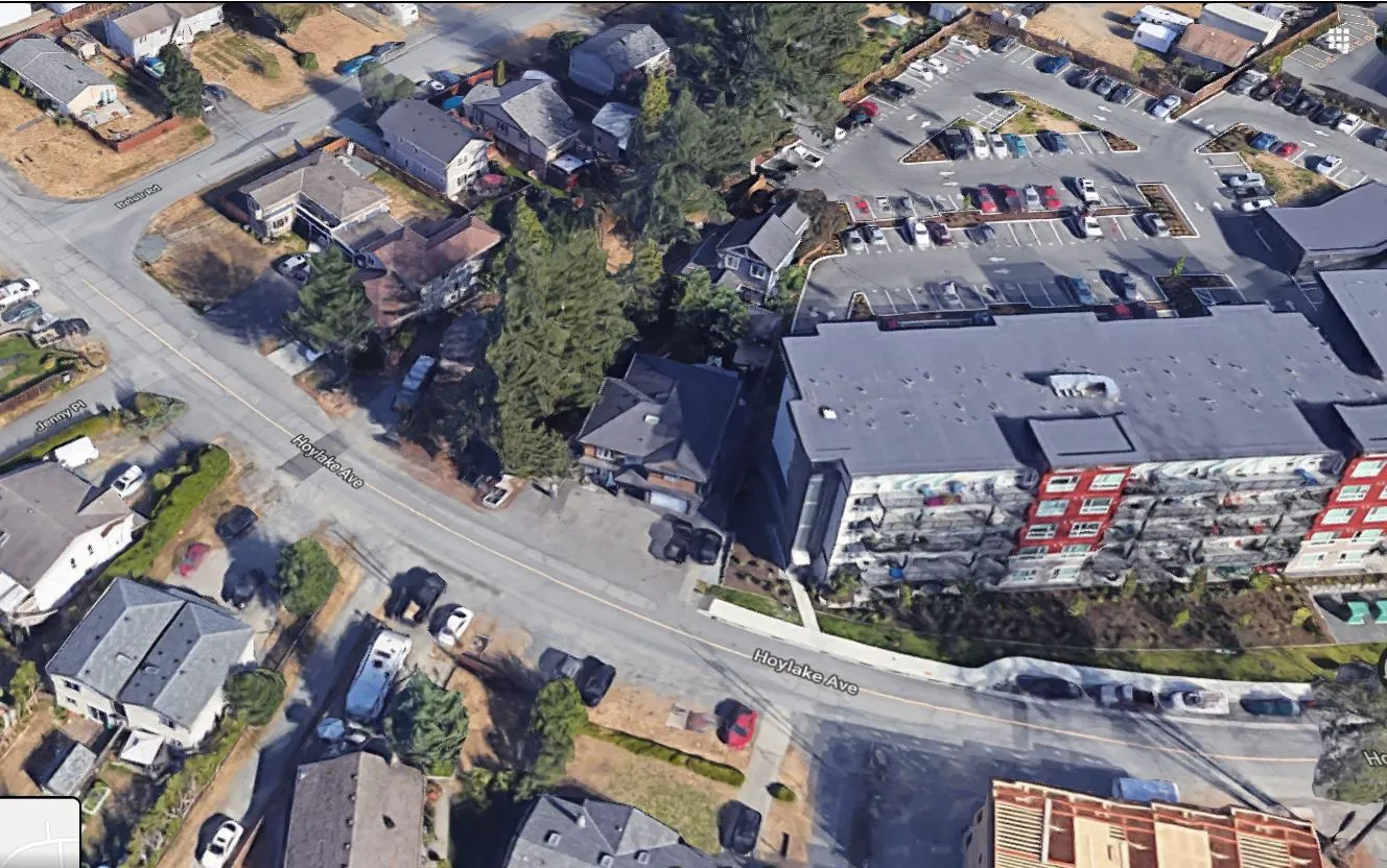
The fairly flat subject property currently contains a single family dwelling and, at approximately 724 m2, is slightly larger than the typical single family lot.
The subject property is adjacent to older single-family and two-family dwellings on the north side of Hoylake Ave. A tributary to Millstream Creek runs behind these homes.
On the edge of the Millstream/Treanor Neighbourhood Centre designation of the OCP, Hoylake Avenue has seen moderate to high density residential redevelopment. The north side of Hoylake Avenue, primarily within the Neighbourhood designation, has been redeveloped into lower density residential developments, mainly townhouses and small lot subdivisions. By contrast, the south side, primarily within the Neighbourhood Centre designation, contains two 74 unit apartment buildings, and may see additional mixed-use and higher density residential developments in the future.
Approximately 200 m north of the property is a portion of Langford that has been designated as Business or Light Industrial within the OCP. Existing in this area are several light industrial uses as well as Western Speedway, an entertainment facility historical to the Langford landscape that provides car racing and other motor sports that generate a distinguishable amount of noise when in operation. As it can be anticipated that future residents of the proposed townhouses will be subject to this noise, Council may wish to have the developer register a Section 219 Covenant on the property that acknowledges this as a nuisance.
Table 2: Surrounding Land Uses
| Location | Zoning | Use |
|---|---|---|
| North (688 and 686 Hoylake Ave) | R2, One and Two Family Residential, Zone | Semi-detached Dwellings |
| East (682 Hoylake Ave) | R2, One and Two Family Residential, Zone | Single Family Detached Dwelling |
| South (691 Hoylake Ave) | C6A, Neighbourhood Mixed Use, Zone | Multi-Family Residential (74 unit Apartment building) |
| West (696 Hoylake Ave) | RM7A, Medium Density Apartment A, Zone | Townhouses (10 units) |
COMMENTS
OFFICIAL COMMUNITY PLAN
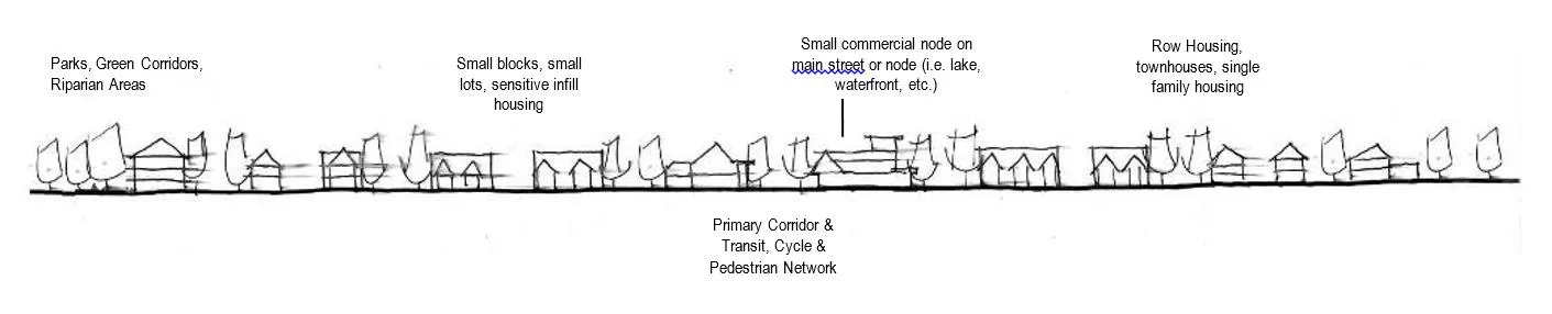
As a property on the boundary of both the Neighborhood and the Neighborhood Centre Official Community Plan (OCP) designations, the proposed redevelopment aligns with policies that encourage densification within walking distance to a Neighbourhood Centre while also being sensitive to surrounding lower density Neighbourhood areas, where a density of 16 unit per acre is anticipated.
The north side of Hoylake Avenue is within the Neighbourhood designation and thus redevelopment on this side of the street has been to mid-scale residential developments including townhouses. The south side of Hoylake Avenue is where higher density and commercial uses are appropriate under the Neighbourhood Centre OCP designation. Redevelopment on this side has included the aforementioned apartment building but also a small lot subdivision across from Millstream Elementary, which may be a more appropriate density given its proximity to the school and the potential for traffic generation resulting from higher density developments.
Neighbourhood
- Predominantly residential precinct that supports a range of low and medium density housing choices including secondary suites
- This area allows for residential and mixed use commercial intensification of streets that connect centres and/or are serviced by transit
- Schools, community facilities and other institutional uses are permitted throughout the area
- Retail serving local residents is encouraged along transportation corridors
- Parks, open spaces and recreational facilities are integrated throughout the area
- This area allows for Neighbourhood Centres to emerge in the form of medium density mixed-use nodes at key intersections.
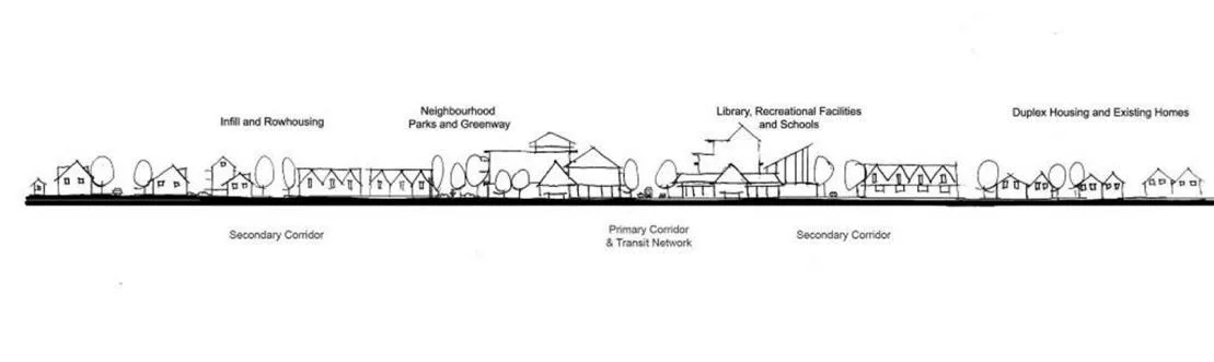
Neighbourhood Centre
- Predominantly residential precinct that supports a range of medium and high density housing, including affordable and rental housing
- Schools, community facilities and other institutional uses also define neighbourhood centres when supported by housing and services in close proximity
- A range of parks and open spaces are integrated throughout centres
- Transit stops are located at centres where appropriate
- Small scale local-serving retail node defines the predominant commercial uses
A Concept for a Neighbourhood Centre on the Valley Floor
DEVELOPMENT PERMIT AREAS
As the subject property is within 43 m of a watercourse, a tributary that flows into Millstream Creak, it is within the Riparian Development Permit Area and as such will require a development permit supplemented with reports from a registered professional biologist. These reports must provide specific recommendations to preserve the area around the watercourse and specify the types of mitigation measures that will be implemented during the construction phase of development to ensure there is no disturbance to the creek.
As a proposed multi-family residential building the proposal is within the Multi-Family Residential Development Permit Area, and thus would be reviewed for compliance with the General Multi-Family Residential Design Guidelines (Appendix H of Bylaw No. 300). The guidelines for multi-family residential buildings include unit entrances at grade, the incorporation of river rock as a design element and landscaping buffers along each side of the property line. While the submitted plans do not include these, further review will be conducted at the Development Permit stage of the approval process wherein those features may be requested.
PEDESTRIAN, CYCLING AND MOTORIST NETWORK
Hoylake Avenue is local residential road that links Millstream Road with Treanor Avenue, a collector road that runs perpendicular to Millstream Road. Sidewalks exist along Hoylake Avenue, to coincide with the redevelopment on the street. In accordance with Bylaw No. 1000, sidewalks are required on the other side of Hoylake. Sidewalks were installed on the Millstream Road frontage of 697 Hoylake Avenue and the Hoylake Avenue frontage of 671 Hoylake Avenue as a condition of developing that property into its current use. Otherwise, the only sidewalks that exist in the Hoylake neighbourhood are those along Hoylake Crescent, a small lot subdivision between Millstream Elementary and Treanor Avenue.
Bike lanes have been installed along Millstream Road to facilitate bicycle traffic north to the community of Bear Mountain and south to Langford City Centre and on to the City of Colwood, as Millstream Road becomes Veterans Memorial Parkway. Given the minimal, mostly residential, traffic on Hoylake Avenue coupled with its access to the existing bike lanes on Millstream Road, it is not anticipated that bike lanes will be installed along Hoylake Avenue.
The Millstream Creek Trail system has an access point on Hoylake Avenue, via the property at 648 Hoylake Avenue. This trail connects Goldie Avenue, including Goldie Park, with Millstream Rd and Treanor Avenue, as well as south to Selwyn Road.
The subject parcel is a close walk to the No.52 bus route which travels northbound and southbound along Millstream Road between Langford and downtown Victoria. Also within walking distance are the No. 47 bus that runs between Goldstream Meadows to downtown Victoria, the No. 56 bus which runs between downtown Langford to Thetis Lake and the No. 57 bus which runs between Westhills to Thetis Lake. These bus routes run east and westbound along Treanor Avenue.
INFRASTRUCTURE
Municipal sewer is available to the property along Hoylake Avenue. The developer will have to connect to and/or upgrade utilities and infrastructure as required to service the site to its proposed capacity. Council may wish to have this secured within a Section 219 registered on the property, so as the developer and future owners of the property are aware of this responsibility.
As there is no municipal stormwater infrastructure in this area, the developer submitted a stormwater management plan, which has been approved by the Director of Engineering. As a condition of this approval, a section 219 covenant must be registered with the property that ensures that on-site infrastructure to manage the drainage will be maintained and updated as needed to comply with the Plan. Any changes to the proposed development that may dictate an update to this Plan must be reviewed by the Director of Engineering prior to the approval of a subdivision or building permit on the property.
The subject property is in an area deemed to be of a low fire risk in accordance with Map 19: Interface Fire Hazard Areas, of Langford’s OCP, Bylaw No. 1200. In order to ensure the control of an urban fire in this location, the fire department has requested that the developer widen the access road into the subject property as part of the redevelopment of the adjacent lot, if at all possible, as it is currently only 3.7m in width.
The developer will be required to submit fire underwriters survey (FUS) calculations to determine the water flow at the site and whether the building setbacks proposed are adequate to achieve the desired water flow necessary to combat a fire. FUS calculations shall be submitted prior to a development permit being issued, a provision that should be secured within a Section 219 covenant registered on the property.
FRONTAGE IMPROVEMENTS
Frontage improvements shall be the responsibility of the developer, installed in accordance with Bylaw No. 1000 and may include boulevard landscaping, on-street parking and street lighting. Sidewalks are not required within the street frontage in accordance with Bylaw No.1000, as they are required on the opposite side of Hoylake Avenue. In accordance with the Subdivision and Servicing Bylaw No. 1000, and the Street Atlas for Hoylake Road. Council may wish to have a Section 219 covenant registered on the property that secures the developer’s responsibility for constructing and installing frontage improvements, in accordance with the standards of the Bylaw and to the satisfaction of the Director of Engineering.
DEVELOPMENT PROPOSAL
The developer is proposing to densify the site by constructing 6 townhouse units, as a stacked townhouse unit configuration, within a three storey building. The three storey design of the building provides an appropriate building height transition between the 5 storey apartment building across the street to the south, and the single family dwellings to the north of the subject property.
A stacked townhouse design, with dwelling units on top of one another other, has been proposed within a single building so as the developer can densify the site as proposed. A stacked townhouse configuration does not occupy the same amount of space as a typical attached townhouse model, as each unit entrance is not uniformly placed to access one thoroughfare, nor does each unit have access to private open space at grade. Each of the six units is proposed to have access from grade, with two entrances off of Hoylake Avenue and the additional 4 entrances at the northeast of the building. While each of the units have their private outdoor open space in the form of a balcony, two of the units have at grade porches that extend to the property line shared with the boulevard.
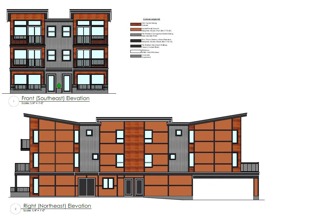
The design of the building incorporates a variety of materials, differing roof angles, extensive fenestration and trim that overall aligns with the aesthetic goals of Langford’s Design Guidelines for Multi-Family Residential Developments (Appendix H of Zoning Bylaw No.300).
The developer is proposing minimal landscaping in order to comply with the parking requirements contained within the Zoning Bylaw. That stated, a fence or other type of screening will be required along with some landscaping along the property lines. In addition to the onsite landscaping, the large boulevard will have to be landscaped in accordance with Bylaw No.1000. Council may wish to ask the developer to provide extensive landscaping in the boulevard, beyond the standard requirements, to make up for the lack of onsite landscaping being provided elsewhere on the property. If supportive, Council could request that boulevard landscaping be designed by a landscape architect and approved by the Director of Planning and Parks Manager to ensure it goes beyond the standards of Subdivision and Servicing Bylaw No.1000. Council could secure the provision for extensive landscaping, as well as for the future strata to maintain the boulevard through a Section 219 covenant, registered on the subject property.
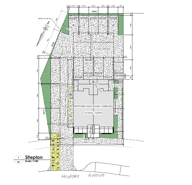
Vehicle access to the property is proposed to be from a 3.7 m wide driveway access on the west side of the property. Given the narrow width of the driveway a vehicle entering or exiting the property may not have knowledge of another vehicle doing the same until they are already at the road edge, forcing one vehicle to reverse the length of the driveway back into the parking lot. To avoid this the developer will install a mirror at the corner of the drive aisle to allow drivers to see when cars are entering the surface parking lot.
The developer has proposed surface parking, along the west side and rear of the property, contained partially underneath the building. Parking to support the 6 units must be in accordance with the Zoning Bylaw No.300 for attached housing and townhouses subdivided as per the Strata Property Act (Table 4.01.01 of Zoning Bylaw No.300). Two vehicle spaces per unit are required along with 2 visitor parking spaces, for a total of 14 spaces. Given the size of the property, slightly larger than a conventional lot for a single family dwelling, it may be difficult to provide the required parking as surface parking while maintaining the necessary spatial dimensions for driving and maneuvering. As such the developer has adjusted the size of several of the resident parking stalls so as they can be considered “small car” parking stalls, which are permitted under the current Zoning regulations. These small car parking stalls will improve the vehicles ability to maneuver but will also restrict the type of vehicle residents can park in these stalls. Council may wish to have the developer provide a turning template, prior to Public Hearing that illustrates how maneuvering into those parking stalls parallel to the driveway will occur, and whether the proposed parking layout is functional.
As mentioned, the size of the subject property is only slightly larger than what is considered a conventional single family lot. As the property is 725 m2, the building’s footprint is proposed to cover 42% of the property, which is just below the 45% lot coverage limit. All of the required setback regulations within the R2MA zone will require variances to accommodate the building and surface parking configuration as presented. If Council wishes to support the following variances they can do so by authorizing the Director of Planning to issue these variances through the subsequent development permit needed to review form and character of the proposal. A table of the requested variances is as follows:
| Location of Setback Variance | R2MA Requirement | Requested by Developer |
|---|---|---|
| Front Property Line | 5.5 m | 3.6 m |
| Front Property Line Projection (balcony) | 4.5 m | 1.6 m |
| Interior Side Setback | 3 m | 2.75 m |
| Rear Setback | 7.5 m | 5.4 m |
The developer is requesting to vary the required building setback to the front property line from the required 5.5 m to 3.6 m to accommodate the front façade of the building. This setback would be further reduced to allow a 1.6 m setback to the front property line for the second story balconies, as this goes beyond the 1 m projection allowed within Bylaw No.300. A reduced setback for the upper storey balconies may allow for additional private open space and a better street to building interaction for pedestrians and residents. Due to the expansive boulevard in the building’s frontage, there will be an impression of a larger building setback than is proposed, and this may mitigate the issues caused by allowing a reduced front building setback. If Council does choose to authorize the Director of Planning to issue this variance within the development permit they may wish to request that the developer register a Section 219 Covenant ensuring there are no encroachments into the City property as a condition.
Allowing reductions to the required side and rear yard building setbacks may cause issues with overlooking into the rear yards of the adjacent two-family dwellings as there are second story balconies located along the rear elevation of the building. If Council chooses to allow this proposed development to proceed as proposed, Staff will request that the developer install privacy screening around these balconies.
Council should be aware that the developer is potentially over developing the site, and while this form of density is encouraged in this location, the site itself may be too small to accommodate the proposed development. Council may wish to ask the developer to redesign the site so as fewer variances are needed, less parking is required, the driveway is more functional, and there is space for landscaping and screening. If Council feels a redesign is necessary they may wish to request that the developer provide this prior to Public Hearing.
Table 3: Proposal Data
| Permitted by R2 (One and Two Family Residential) Zone | Permitted in the RM2A (Attached Housing) Zone | Proposed by this Development |
|---|---|---|
| Density (FAR and/or min. lot size) | Minimum lot size = 550 m2 | FAR = 1 |
| Height | 9 m | |
| Site Coverage | 35% | 45% |
| Front Yard Setback | 6 m | 5.5 m |
| Interior Side Yard Setback | 1.5 m | 3 m |
| Exterior Side Yard Setback | 4.5 m | 5.5 m |
| Rear Yard Setback | 6 m | 7.5 m |
| Parking Requirement (Section 4.01.01) | 2 spaces per dwelling unit | 2 spaces per dwelling, 2 visitor spaces for developments with less than 10 units |
*Variance
FINANCIAL CONTRIBUTIONS
FINANCIAL IMPLICATIONS
Rezoning the subject properties to permit higher density of development will increase the assessed value of lands and eventually will increase municipal revenue due to the number of units created. As the developer is responsible to complete all frontage improvements, servicing connections and upgrades necessary to service the site, the direct capital costs to the City associated with this development will be negligible. A summary of Amenity Contributions and Development Cost Charges that the developer will be expected to pay, is outlined in Tables 4 and 5 below
COUNCIL’S AFFORDABLE HOUSING, AND GENERAL AMENITY RESERVE FUND CONTRIBUTION POLICY
The amenity contributions that apply as per Council’s current Affordable Housing, and Amenity Contribution Policy are summarized in Table 4 below, based the current floor plans and total density of 6 units.
Table 4 – Amenity Contributions per Council Policy
| Amenity Item | Contribution | Total @ 6 units |
|---|---|---|
| Affordable Housing Policy | $610 per unit | $3,660 |
| General Amenity Reserve Fund | $3660 per unit | $21,960 |
| TOTAL POLICY CONTRIBUTIONS | $4,270 per unit | $25,620 |
DEVELOPMENT COST CHARGES
The following Development Cost Charges (DCCs) may be bonded for or paid prior to the issuance of a building permit to construct the site.
Table 5 – Development Cost Charges
| Development Cost Charge | Per unit contribution | Total @ 6 units |
|---|---|---|
| Roads | $3188 | $19,128 |
| Park Improvement | $1890 | $11,340 |
| Park Acquisition | $1100 | $6,600 |
| Incremental Storage Improvement Fees | $371.25 | $2,227.50 |
| Subtotal (DCCs paid to City of Langford) | ||
| CRD Water | $2323.43 | $13,940.58 |
| School Site Acquisition | $558 | $3,348 |
| TOTAL (estimate) DCCs | $9430.68 | $56,584.08 |
OPTIONS
Option 1
That the Planning, Zoning and Affordable Housing Committee recommend that Council:
- Direct staff to prepare a bylaw to rezone the property at 684 Hoylake Avenue from the R2, One and Two Family Residential, Zone to the RM2A, Attached Housing, Zone subject to the following terms and conditions:
a) That the applicant provides, as a bonus for increased density, the following contributions per residential unit, prior to issuance of a building permit: i. $610 per unit towards the Affordable Housing Fund; and ii. $3660 per unit towards the General Amenity Reserve Fund.
b) That the applicant provides, prior to Public Hearing, the following: i. A technical memo from an engineer that verifies storm water can be adequately managed on-site for the proposed developments, to the satisfaction of the Director of Engineering; ii. A turning template that illustrates how motor vehicles will maneuver into the parking stalls located parallel to the driveway; iii. A frontage drawing to the satisfaction of the Director of Engineering to confirm if road dedication is required to complete all required frontage improvements including boulevard landscaping, sidewalks and street lighting (if applicable).
c) That the applicant registers, prior to Bylaw Adoption, a road dedication plan, if required, to the satisfaction of the Director of Engineering;
d) That the applicant provides, prior to Bylaw Adoption, a Section 219 covenant, registered in priority of all other charges on title, that agrees to the following: i. That the developer agrees to install, or bond for, all required frontage improvements to Bylaw No. 1000 standards, including the installation of road edge parking, streetlights, and boulevard landscaping to the satisfaction of the Director of Engineering, prior to issuance of a building permit; ii. That the developer agrees to install underground irrigation to the property, and that irrigation will be extended to the boulevard to the standards of Bylaw No.100 and to the satisfaction of the Director of Engineering; iii. That future maintenance of the boulevard landscaping will be the responsibility of the property owner(s); iv. That the developer will connect and be responsible for any upgrades required to the services and utilities required for the development; v. That all storm water management plan(s) be provided prior to issuance of a building permit and implemented, as per Bylaw 1000, all to the satisfaction of the Director of Engineering; vi. That a construction parking management plan be provide prior to the issuance of a building permit, to the satisfaction of the Director of Engineering. vii. That the required parking stalls for this development are allocated for the use by individuals in each unit and visitors, as required by Bylaw No. 300; and that parking is not separated from individual units nor provided for in exchange for compensation separate than that of the residential unit; viii. That a section 219 shall be registered on each property acknowledging the nuisances that exist from the location close proximity to Western Speed Way; and ix. That the developer submit the Fire Underwriters Survey (FUS) calculations prior to the issuance of a development permit to develop the property, and acknowledges that these calculations may determine different setbacks than what is prescribed in the zone or from what has been granted through variances.
e) That Council authorize the Director of Planning to authorize the following variances within a Development Permit that addresses the form and character of the development:
i. A variance to reduce the required building setback from an interior lot line from 3 m to 2.7 m subject to the following: a. That the developer install screening along the entire perimeter of the property, in accordance with the screening regulations found in Zoning Bylaw No.300; b. That the developer agrees to landscape the boulevard beyond the standards found within Bylaw No. 1000 and in consultation with a professional Landscape Architect, to the satisfaction of the Director of Planning and Parks Manager;
ii. A variance to reduce the required building setback from a rear lot line from 7.5 m to 5.5 m subject to the following; a. That that privacy screens are installed along the rear and sides of the balconies located on the rear elevation;
iii. A variance to reduce the required building setback from front lot line from 5.5m to 2.6 m subject to the following: a. That the applicant register a Section 219 Covenant on the property acknowledging that they will not require an encroachment agreement onto City property as a result of receiving a variance to the required building setback from the front property line;
iv. A variance to the allowable projection limits for a front property line from 4.5 m to 1.6 m;
Option 2
- Take no action at this time with respect to an application to rezone the property at 684 Hoy Lake Avenue.
Submitted by:
Lauren Morhart, MCIP, RPP, Planner 2
Concurrence:
- Matthew Baldwin, MCIP, RPP, Director of Planning
- Cory Manton, Manager of Parks and Recreation
- Michelle Mahovlich, P.Eng, P.Geo, Director of Engineering
- Leah Stohmann, MCIP, RPP, Deputy Director of Planning
- Michael Dillabaugh, CPA, CA, Director of Finance
- Braden Hutchins, Director of Corporate Services
- Braden Hutchins, Acting/Chief Administrative Officer
:lhm
Document Images
(2)