DocumentsStaff ReportNov 25, 2019Pages 21–40
Staff Report: Application to Rezone 804 Latoria Rd and 950 Worrall Dr (Z17-0046) - to Planning, Zoning and Affordable Housing Committee
Planning staff report (Z17-0046) recommending rezoning of 804 Latoria Road and 950 Worrall Drive from RR2 to an R5/R-type zone to accommodate a mixed residential development, describing site context, OCP, environmental/development permit requirements, proposed density, community benefits and conditions.
Key facts
- Applicant: Adam Weir on behalf of Ridley Bros Development Ltd
- Civic addresses: 804 Latoria Road and 950 Worrall Drive
- Property size: ~29.642 hectares
- Proposed zoning: from RR2 (Rural Residential 2) to R5 (One-Family Residential 5) (staff report text)
- Proposed development: mix of one-family homes (including small lot homes), townhouses, community facility and potential Sooke School District school site (~2.84 ha)
Staff Report: Application to Rezone 804 Latoria Rd and 950 Worrall Dr (Z17-0046) - to Planning, Zoning and Affordable Housing Committee
Date: July 8, 2019
Department: Planning
Application No.: Z17-0046
Subject: Application to Rezone 804 Latoria Rd and 950 Worrall Drive from RR2 (Rural Residential 2) to R5 (One-Family Residential 5) to accommodate a residential development that includes a variety of housing types and the potential for a school site, public open space and community facilities.
PURPOSE
Adam Weir has applied on behalf of Ridley Bros Development Ltd. to rezone 804 Latoria Road and 950 Worrall Drive from the RR2 (Rural Residential 2) Zone to the R5 (One-Family Residential 5) Zone to allow for a development consisting of the single-family equivalent (SFE) of 450 dwelling units that will be a mix of one family homes on small lots, townhouses as well as recreational amenities, a community facility and a potential Sooke School District school site.
BACKGROUND
Table 1: Site Data
| Item | Details |
|---|---|
| Applicant | Adam Weir |
| Owner | Ridley Bros. Development Ltd |
| Civic Address | 804 Latoria Road and 950 Worrall Drive |
| Legal Description | Lot 4, Section 70, Metchosin District, Plan 1957, PID 005-035-511 (804 Latoria Road) Lot A, Section 71, AND Section 77, Metchosin District, Plan VIP59646, PID 018-911-790, (950 Worrall Drive) |
| Size of Property | 29.642 ha |
| DP Areas | Potential Habitat and Biodiversity Environmental Riparian Area Environmental Interface Fire Hazard (High) Steep Slopes Hazard |
| Zoning Designation | RR2, Rural Residential 2, Zone |
| OCP Designation | Hillside or Shoreline |
SITE AND SURROUNDING AREA
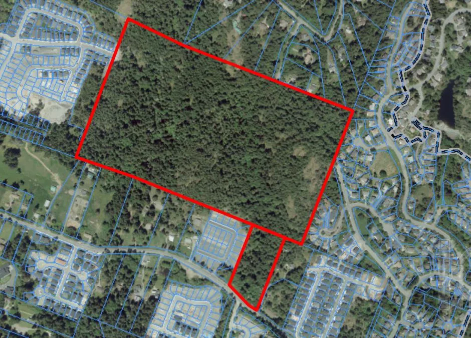
The two properties are situated between Walfred Road and Latoria Road and encompass approximately 30 ha (73 ac) of land within the South Langford Neighbourhood Area. This Neighbourhood Area is predominantly residential, and contains subdivisions with a variety of lot sizes as well as large rural residential properties. Along Latoria Road, south of the subject property, several properties exist that are within the Agricultural Land Reserve, and cannot be developed beyond farm uses without the approval of the Agricultural Land Commission. Rezoning the subject property will align with the varied context of the immediate neighbourhood as it will allow a variety of housing types comparable to existing developments in the Area.
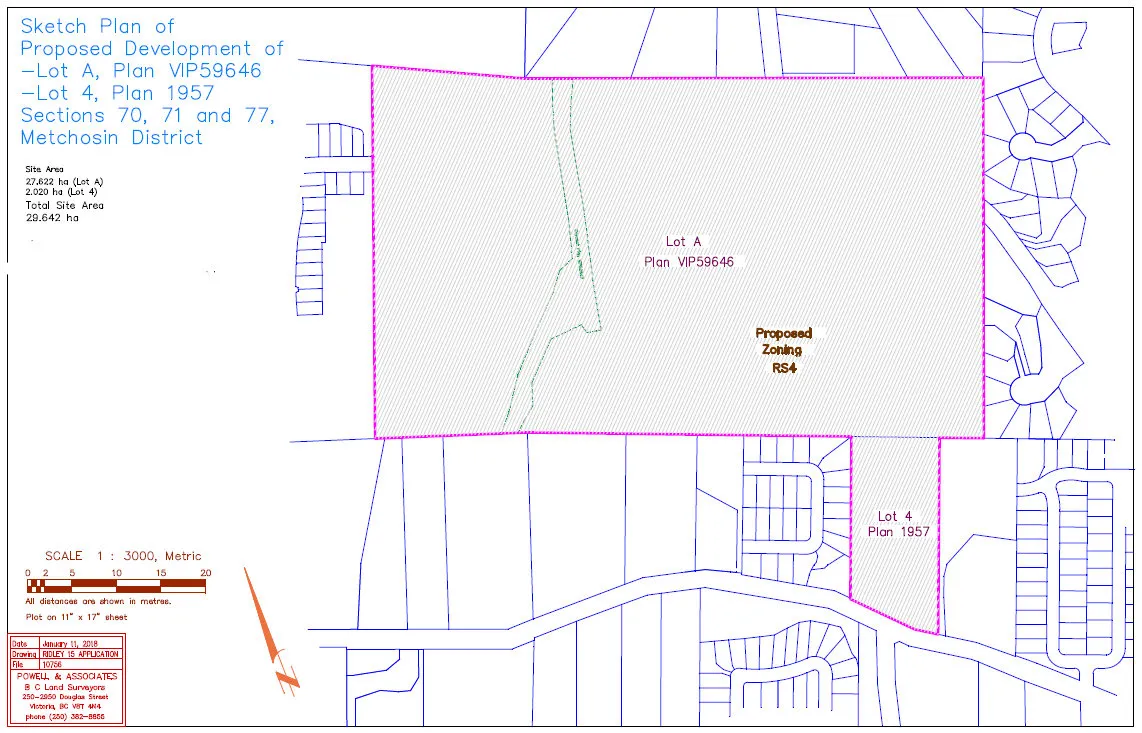
Table 2: Surrounding Land Uses
| Location | Zoning | Use |
|---|---|---|
| North (Various 700 Blk of Walfred Road and 900 Blk of Worrall Drive) | RR5, Rural Residential 5, Zone | One Family Dwellings |
| West (1067 Braeburn – undergoing subdivision) | CD15, Comprehensive Development 15 – McCormick Meadows, Zone | One Family Dwellings, Townhouses |
| South (1000 Blk of Golden Spire Crescent) | RR6A, Rural Residential 6A, Zone | One Family Dwellings |
| South (830, 840 and 854 Latoria Road) | RR2, Rural Residential 2, Zone | One Family Dwellings and Farm Use |
| South (866 Latoria Road, undergoing subdivision) | RR6 and RM2A | One Family Dwellings, Townhouses |
| South (934 -910 Latoria Road) | AG1, Agriculture 1, Zone | One Family Dwellings and Farm use |
| East (Various along Wendey Dr, Monica Terrace, Columbus Place and Sunheights Drive) | R2, One and Two Family Residential, Zone | One Family Dwellings |
COMMENTS
OFFICIAL COMMUNITY PLAN
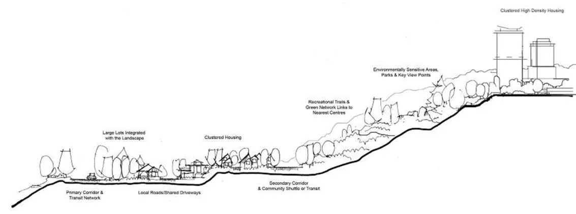
The subject property is designated as “Hillside or Shoreline” within Langford’s Official Community Plan (OCP). This designation, as described within the OCP, is assigned to existing low intensity settled areas that have a high percentage of open space, and are undeveloped areas located on hillsides or in close proximity to shorelines.
Hillside or Shoreline
- Predominantly residential precinct that supports a range of clustered (See Glossary & next page) low, medium and high density housing choices including secondary suites. Higher building forms, such as point towers, will be permitted on hillsides to maximize open space provided some conditions are satisfied (see policies for this area)
- Schools, community facilities and other institutional uses are permitted throughout the area
- Home-based businesses, live-work housing is encouraged; Home-based accommodations (e.g. Bed & Breakfasts) are permitted.
- Parks, open spaces and green corridors (creeks, wildlife corridors, trails, etc.) are integrated throughout the area. Large playfields are discouraged due to grading requirements. Site and topographic responsive pocket parks, enhanced viewpoints, graded hiking and walking trails, children’s play areas, including ‘tot lots’ and outdoor exercise areas are strongly encouraged on hillside areas.
- This area allows for Neighbourhood Centres to emerge in the form of high and medium density clustered mixed-use nodes
- Transit stops are located where appropriate
A Concept for the Hillside Shoreline Areas
As per Policy 1.1.1 (below) greenfield properties designated Hillside or Shoreline, within OCP, are to retain 40% of the total parcel as open space. This allotment may be reduced to 25% of the property as open space if Council determines they have provided a significant community contribution as an alternative.
3.11 Hillside or Shoreline Areas
Objective 1.1 Retain significant open space and maintain ecosystem values.
Policy 1.1.1
When considering development on greenfield sites, retain a minimum of 40% of the site area as public and/or private open space. 25% open space retention will be considered if other conditions that are provided deliver significant community benefit such as affordable housing are met. If a NAP or NCP is in place, each subdivision application will benefit from the overall conditions of the NAP as it relates to open space retention on an area-wide basis. That is, if 40% of the area has been retained for open space through the area-wide plan, individual parcels created through subdivision within designated development areas in the NAP will not be expected to achieve the 40% open space on a site by site basis.
SOUTH LANGFORD NEIGHBOURHOOD PLAN
The subject property is designated as a property with ‘Rural with Heritage Values’ within the South Langford Neighbourhood Plan. This designation applies to areas where the traditional land use of a property may be of significance to the history and culture of Langford. An average density of 1 lot per 12 ha applies to this designation. While the density proposed as part of this rezoning application exceeds that suggested by this South Langford Neighbourhood Plan designation, it does meet the intent of the low density residential policies found within the OCP. It is anticipated that policies within the South Langford plan will evolve with the continued development of the South Langford area to relate to current market and density demands and remain consistent with the OCP Neighbourhood designation.
DEVELOPMENT PERMIT AREAS
Due its size, the subject property is within several development permit areas including the High Risk Fire Hazard, Steep Slopes, and Floodplain Development Permit areas. It is also within the areas subject to environmental review including the Potential Habitat and Biodiversity and Riparian Development Permit Areas. As such, development permits to develop the property must be supplemented with reports from appropriate professionals. These reports must provide specific recommendations to preserve and enhance the environmental aspects of the site and ensure mitigation measures will be implemented during the construction phase of development.
Development Permits will also be required to review the character and layout of development, when required under Langford’s Design Guidelines for Form and Character. These include townhouses and any one family dwellings on parcels that are less than 550 m2.
The OCP designates the Riparian Development Permit Area as being 43 m from either side of the high-water mark of a water body. This 43 m setback acts as a buffer to the Riparian Area to ensure that erosion and sediment control plans and environmental mitigations are in place and the riparian areas are protected during development. Any construction or land alteration that is proposed within this 43 m Development Permit Area requires that a Development Permit be issued by the municipality, and include a Riparian Areas Assessment Report drafted by a Registered Professional Biologist to clarify appropriate environmental mitigation measures and to define the Streamside Protection and Enhancement Area, or SPEA. The SPEA is a non-disturbance natural area, and no development or alteration of the land is permitted between it and the water body or stream.
Riparian Areas exist on the subject property, and coincide with the two streams that run parallel from north to south on the subject property located at 950 Worrall Drive. The Riparian Areas Assessment report prepared by Cordivae has contemplated a SPEA non-disturbance area of 15 m from the high-water mark on either side of each of the streams.
PEDESTRIAN, CYCLING AND MOTORIST NETWORK
Currently the property at 804 Latoria Road is accessed via Latoria Road, a road in the South Langford area that runs perpendicular from Happy Valley Road and connects to Veteran’s Memorial Parkway, in the City of Colwood. The larger property, at 950 Worrall Road, can be accessed from Worrall Road, which connects the property to Walfred Road.
In order to facilitate access to these properties, Braeburn Avenue and Honey Crisp Avenue, to the west of the subject property, are proposed to extend into the property at 950 Worrall Drive and continue through connecting it to Wendey Drive. Worrall Drive may also be realigned to provide a connection to the development. As future internal road networks will be finalized and approved as part of the subdivision approval of the property, a traffic impact assessment is required to determine how these new roads will function. A traffic impact assessment, approved by the Director of Engineering, will be required prior to Public Hearing. Depending on the approved use of the site at 804 Latoria Road, roads within the rest of the development may connect to Latoria Road.
As a residential area that is in the process of growing out to an urban density, infrastructure dedicated to providing alternative transportation in and around the established areas north and east of the site is also developing. Development west and south of the property will include infrastructure to support pedestrian transportation. Sidewalks have been installed in the subdivision west of the subject property and will connect, where required, to those placed along the internal roads of the subject subdivision in accordance to the Subdivision and Servicing Bylaw No.1000 standards.
Bike lanes exist along Latoria Road and facilitate bicycle traffic west towards Happy Valley Road and east towards Colwood. A bike lane already exists in the frontage along 804 Latoria Road.
BC Transit operates route 55, Happy Valley, with service east and west bound along Latoria Road and onto Happy Valley Road to the Langford bus exchange on Station Avenue. The closest bus stop to the subject property is approximately 400 m from the property at 804 Latoria Road. It can be anticipated that the continued development in the area could lead to increased bus services to these and neighbouring properties.
Frontage improvements along Latoria will be in accordance with the Bylaw No.1000 standards and will include road side multi-use pathway, a middle turn lane, and streetlights as well as an access point to Latoria Road, depending on the approved use of the property at 804 Latoria. Council may wish for the applicant to demonstrate whether road dedication is necessary to accommodate these improvements prior to Bylaw Adoption, to the satisfaction of the Director of Engineering. Road dedication, if required, should be provided prior to subdivision approval.
INFRASTRUCTURE
Municipal sewers has been brought to Golden Spire Crescent off of Latoria Road as well Braeburn Avenue in McCormick Meadows. It will be the responsibility of the developer to extend sewer to the proposed subdivision, and install any upgrades or other requirements necessary to bring sanitary sewer servicing to the site.
If the applicant proposes to phase the development, temporary emergency access points must be included in the plans submitted with each phase. As well, a Fire Underwriters Survey (FUS) must be submitted at time of building permit or subdivision approval, whichever is first, that proves the water flow necessary to comply with the FUS calculations are available to the subject site.
A technical stormwater management memo will be required prior to scheduling the Public Hearing of the Bylaw. A formal stormwater management plan must be submitted prior to subdivision approval.
DEVELOPMENT PROPOSAL
The developer would like to rezone the subject property from the RR2, Rural Residential 2, Zone, to a new R5, One-Family Residential 5, Zone that will include up to 450 single family equivalent dwelling units made up of one family dwellings and townhouses. The R5 Zone will also list secondary suites in one family homes on lots larger than 400 m2, schools, group day cares and community facilities as allowable uses. Staff felt that the creation of a new zone was warranted given the size of the subject property, the allowable uses being proposed, and to include regulations tied to density that require the development of affordable housing.
The developer is planning to construct up to the single-family equivalent (SFE) of 450 dwelling units. SFEs are calculated so as a one family dwelling on a standard sized lot of 550 m2 or greater would be considered 1 dwelling unit, whereas smaller homes on lots less than 550 m2 and townhouses would be considered less than the equivalent of a conventional one family dwelling. If Council is interested in limiting the density on the property, they may want to consider a cap of 450 SFE as the developer has proposed. Council may want to limit the number of townhouses that can be constructed on the site to 61 SFE which would allow the developer to build 100 townhouse units on the subject property. If Council is supportive of limiting the density in this way, it should be included as part of the density regulations within the zone.
Table 3: Single Family Equivalent Chart
| Dwelling Type | SFE |
|---|---|
| One Family Home | 1 |
| One Family Home on a Small Lot (less than 550 m2) | 0.66 |
| Townhouse | 0.61 |
The Hillside or Shoreline OCP designation contemplates areas where open spaces, parks, wildlife corridors and trails are integrated throughout a developed property in locations appropriate given the topography and site conditions. In order to ensure open space is retained on properties within the designation, the Hillside or Shoreline Policy requires that 40% of the property being developed is set aside as open space. The caveat to this is:
“that 25% open space retention will be considered if other conditions that are provided deliver significant community benefit such as affordable housing are met.”
To this end the developer would like Council to consider aspects of his proposal as qualifying as “significant community benefits,” to allow for the 25% open space retention, in accordance with the policy excerpt above.
Proposed Open Space Components and Community Benefits
SPEA Non-Disturbance Open Space & Dedicated Open Space
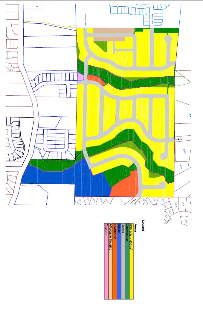
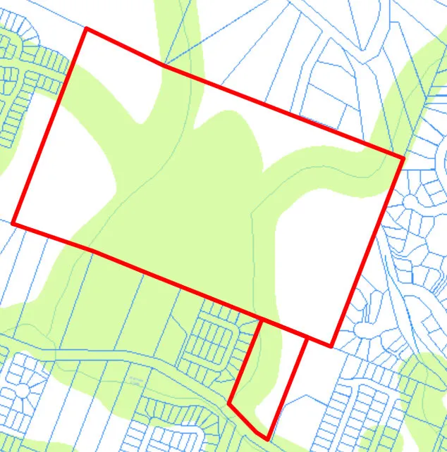
As shown in the Environmental Assessment and Riparian Area Report (RAR) prepared by Cordivae Environmental Consultants, and in Figure 4, two creeks run north to south through the property to create a SPEA area of approximately 3.85 ha. This SPEA area must be protected as a non – disturbance area in accordance with the Provincial Riparian Area Regulations. In accordance with the RAR, the SPEA generated non-disturbance open space equates to approximately 3.85 ha of the total subject property of 29.64 ha, or 13% of the total site.
The developer has proposed to dedicate open space, in the form of small parks and a trail system, to the City. As a condition of rezoning, the property directly south of the subject property (866 Latoria Road), was required to provide a 9.5 m wide green space and trail along the western portion of the property and extending from Latoria Road to the northern boundary shared with 905 Worrall Drive. To facilitate a usable community amenity, this trail should be connected and brought through the subject property, along the SPEA boundary as warranted, at a standard and extent that is to the discretion of the Manager of Parks. The developer will be responsible for the construction of this portion of the trail, which may be constructed as a “Natural Trail” as defined within Bylaw No. 1000, wherein the trail can be narrower with less infrastructure needed to support it. If Council is supportive of this, they may allow that these improvements to the trail be credited towards the Developer’s Development Cost Charges for Park Improvements. The amount and location of land dedicated to the creation of this trail connection, and costs associated with construction of the trail should be determined in consultation with the Manager of Parks and included as part of the Master Development Permit, required prior to the approval of any subdivision on the property.
School-site Open Space
The Sooke School District has shown interest in purchasing a portion of the property, approximately 2.84 ha (7 acres) to be developed as a school site. As with any school, a portion of this site will include an area for students and the surrounding community to use as open space, and the school itself will probably only occupy about 45% of the site. The applicant has requested that the playing fields developed on the school site be included towards the open space calculation for the development as a whole (25% of the total land area). This is anticipated to include approximately 1.56 ha of land, or 55% of the school site.
Private Open Space
The developer would like to provide a portion of the required open space as covenanted non-disturbance open space on private property. Properties with covenanted open space would have a Section 219 covenant registered with their property designating a portion of their yard space as non-disturbance protected area that may not be altered or built upon in any way. If Council is supportive of including this type of open space towards the policy requirement, the developer would like some flexibility on the location of these covenanted areas due to the topography and development potential of the property. Council may wish to require that these non-disturbance open spaces be located adjacent to the areas identified as SPEA, whenever possible, as this will serve to expand the SPEA non-disturbance areas as wildlife corridors. Also, in the interest of preserving these as open space areas, Council may wish to require the developer to install screening in the form of a fence or wall so private owners are not confused as to what portion of their yard is usable space and what has been covenanted as non-disturbance area.
Council may also wish to allow for private non-disturbance areas, outside the SPEA, to be disturbed during time of construction and development, as long as these areas are remediated to a natural state once site preparation on the property subject of the covenant has been completed, and prior to subdivision approval. A replanting plan should be prepared by a Registered Professional Biologist, and a cost estimate for the replanting bonded against prior to the issuance of a building permit for the first one family dwelling that contains non-disturbance area on the property.
The SPEA non-disturbance area is the only fixed amount of open space on the subject property. Council should note that the location and allocation of dedicated park and trail areas, covenanted non-disturbance areas, and open space associated with the school site remain fluid and undetermined due to the development potential, topography and site conditions of the property. A Master Development Permit that includes the location, size, and allocation of open space will be required prior to the approval of any subdivision or land alteration on the property.
Significant Community Benefit: Affordable Homes
The developer is proposing to construct 30 homes (approximately 10% of the development overall) as small lot homes on parcels 200 m2 or less. The first 10 of these homes would be offered for purchase for not more than $399,000. The additional 20 homes will be offered for sale at current market value, however, as they would be on lots less than 200 m2 it is anticipated that they would potentially sell for less than homes on larger lots within the zone. These 30 affordable homes would be required to have 3 bedrooms and there would be no opportunity to construct secondary suites within them.
As the first 10 homes will have a true market value that is potentially greater than $500,000, Council may wish to register a housing agreement on title, prior to subdivision approval, in order to prevent a home owner from reselling the home for market value. Council may wish for staff to further explore options around the structure and content of this housing agreement, which, for example, could allow for a certain degree of appreciation to the home owner based on market value and include a silent second mortgage registered on title held by the City, that would allow the City to gain funds for the Affordable Housing Reserve Fund depending on the time of the sale in relation to the original occupancy and the sale price. As housing agreements must be authorized by Bylaw adopted by Council, these types of details can be further developed over the coming months and presented in full to Council at the time the Bylaw is considered.
If Council wishes to accept the applicant’s proposal to create affordable housing, they may wish to require that the 10 affordable homes be constructed prior to issuance of a building permit for the 101st one family dwelling, and that each subsequent 10 homes (those that are sold at market value) are constructed prior to the 201st and 251st homes accordingly, until 30 homes are constructed. Council may also wish to accept the applicant’s offer to construct these affordable dwellings as an off-set, or significant community benefit, in lieu of open space required in the Hillside/Shoreline OCP.
Council may wish to note that the applicant stands to lose approximately $100,000 in potential revenue from each of the 10 affordable homes (by offering these homes for sale at $399,000), this is essentially a contribution of $1 Million towards the provision of affordable housing. In acknowledgment of this, Council may wish to consider waiving contributions to the Affordable Housing Fund for the 30 aforementioned market and below market affordable homes.
Significant Community Benefit: School Site
Due to the great need for additional schools in this part of Langford, Council may wish to consider the provision of the school site to the Sooke School District as one of the significant community benefits required in order to reduce the greenspace from 40% to 25%. If Council agrees, the school site should be transferred to the Sooke School District prior to the issuance of a building permit for the 101st home constructed on the property. As there is not yet certainty as to whether this will go ahead, Council could include in the Zone an option to increase the open space requirement to 40% in the event the School District decides not to proceed with this site. Limiting the density to 100 homes until this decision is made is early enough in the development process that the Master Plan can still be adjusted to include this revised open space plan.
Significant Community Benefit: $1.5 Million towards a Recreational Amenity
As noted, the Sooke School District has expressed interest in developing a school on the subject property (shown in blue in Figure 4). The developer is proposing to contribute $1.5 million to the City of Langford to construct a recreation amenity in the area close to this proposed school site. This amenity would be dedicated to the City of Langford for maintenance and future management. If Council chooses to accept this as a significant community benefit to offset the open space requirements, they may wish to include regulations tied to the density within the zone that will trigger the contribution. Council may wish to require that $1.5 million is contributed prior to the issuance of a building permit for a school on the site, or in the event that the School Board does not wish to construct a school at the site, then the $1.5 million contribution should be triggered prior to the issuance of a building permit for the 101st home constructed on the property.
Significant Community Benefit: Group Child Care/Community Facility
Addressing a need in the area for both community meeting spaces and child care, the developer is also proposing to construct a community facility within the subdivision that would include a Group Child Care centre. If Council wishes to consider this as a community benefit they can request that the developer set aside a portion of the property for the construction of a community facility. This can be secured within a Section 219 covenant, as well as shown within the Development Permit Master Plan identifying the location of the facility.
Table 4: Proposal Data
| Permitted by RR2 (Current Zoning) | Proposed R5 Zoning |
|---|---|
| Allowable Uses | One or two family dwelling |
| Minimum Lot Size (Density) | 4 ha |
| Height | 10.5 m |
| Site Coverage | N/A |
| Front Yard Setback | 7.5 m |
| Interior Side Yard Setback | 3 m |
| Exterior Side Yard Setback | 3 m (5.5 m to accommodate a driveway) |
| Rear Yard Setback | 10 m |
| Parking Requirement | 2 spaces per unit |
The applicant has not submitted renderings or depictions of the proposed dwellings and therefore they have not been considered against the Langford’s Design Guidelines for intensive residential or multi-family uses (for townhouses). The development permit required to address the environmentally sensitive and hazardous attributes of the site will also include the designs of the proposed homes in order to review their form and character prior to any construction being permitted.
FINANCIAL CONTRIBUTIONS
Council’s Amenity Contribution Policy
The amenity contributions that apply as per Council’s current Affordable Housing, Park and Amenity Contribution Policy are summarized in Table 5 below. The total amount of contributions will be calculated at time of building permit issuance or subdivision approval, as the total number of units has not yet been solidified.
Table 5 – Amenity Contributions per Council Policy*
| Amenity Item | Per Unit Contribution |
|---|---|
| Affordable Housing Reserve Fund (these fees may be waived with Council support) | $1,000 per standard (>550 m2) lot $660 per small (<550 m2) lot $610 per townhouse |
| General Amenity Reserve Fund | $6,000 per (>550 m2) lot $4,182 per small (<550 m2) lot $3,660 per townhouse |
*The applicant will be charged for new lots created at the time of subdivision, and for townhouses or multi-residential unit at the time of building permit issuance.
DEVELOPMENT COST CHARGES
As the developer has not yet submitted a subdivision plan, Council should note that the Development Cost Charges cannot be tallied in a way that will reliably depict the final charges associated with the property. Table 6 provides a breakdown of the DCC charges according to lot size or house type, DCCs are collected at time of subdivision for average size and small lots, and at time of building permit issuance for townhouses. The total amount of DCCs will be determined at the time of building permit or subdivision as a total number of units has not been determined. As mentioned, Council may wish to reduce the amount of DCC credits associated with Park Improvement fees, in an amount equal to the costs associated with installing trail infrastructure, and in consultation with the Manager of Parks. This amount should be determined as part of a Master Development Permit required prior to the approval of a subdivision on the site.
Table 6 – Development Cost Charges
| Development Cost Charge | DCC contribution |
|---|---|
| Roads | $6,506 per standard (>550 m2) lot $3,985 per small (<550 m2) lot $3,985 per townhouse unit |
| Storm Drainage | $1,878 per standard (>550 m2) lot $1,166 per small (<550 m2) lot $1,166 per townhouse unit |
| Park Improvement (Possible reduction associated with the installation of trail infrastructure) | $1,890 per lot created $1,890 per unit constructed |
| Park Acquisition | $1,100 per lot $1,100 per unit created |
| Incremental Storage Improvement Fees | $495 per standard (>550 m2) lot $371.25 per small lot (<550 m2) $371.25 per townhouse unit |
| Integrated Survey Area | $35 per lot |
| CRD Water | $2,655.34 per lot $2,323.43 per townhouse unit (medium density) |
| School Site Acquisition | $698 per parcel created (<21 units/ha) $628 per unit (21 to 50 units/ha) $558 per unit (51 to 125 units/ha) |
*DCC charges are paid at time of subdivision approval for one family dwellings and at time of building permit issuance for townhouses and multi-residential units.
OPTIONS
Option 1
That the Planning, Zoning and Affordable Housing Committee Recommend that Council:
- Accept the following items as community benefits to reduce the 40% open space requirement within Hillside or Shoreline OCP designation to 25% open space:
a. The construction of 10 homes offered for a purchase not exceeding $399,000, with an additional 20 homes offered for sale at market value all constructed on lots 200 m2 or less;
b. A community facility that can support the operation of a Group Child Care centre;
c. The contribution of $1.5 million to construct a recreational amenity;
d. A school site to be owned and operated by the Sooke School District;
- Direct staff to create a Bylaw for the creation of a new R5 (One-Family Residential 5) Zone which will serve to create affordable dwelling units on parcels 200 m2 or less and will also include one family dwellings, townhouses, secondary suites, community amenity space, group day cares, schools and preschools and will restrict the density within the zone in accordance with the following:
a. That there may be no more than 100 residential dwellings constructed on the property until the developer has completed the construction of 10 one family dwellings, that are subject of a housing agreement and that they be offered to the public with a purchase price no greater than $399,000;
b. That there may be no more than 200 residential dwellings constructed on the property until the developer has constructed an additional 10 one family dwellings on lots 200 m2 or less;
c. That there may be no more than 250 residential dwellings constructed on the property until the developer has constructed an additional 10 one family dwellings on lots 200 m2 or less;
d. That the developer contributes $1.5 million towards the construction of a recreational amenity for the City of Langford prior the issuance of a building permit for a Sooke District School or prior to issuance of building permit for the 101st home constructed on the property, whichever is first;
e. That there may be no more than 100 residential dwellings constructed on the property until the developer has transferred a school site to the Sooke School District, or amended their Master Development Permit to include 40% open space;
f. That the overall density in the R5 Zone is limited to 450 single family equivalent (SFE) units, whereas townhouses may not make up any more than 61 SFE units, or 100 townhouse units, and a maximum of 30 one-family dwellings on lots 200 m2 or less are permitted;
Direct staff to apply a Development Cost Charge credit towards the Park Improvement DCCs, for the installation of a trail and associated infrastructure. The DCC Credit for Park Improvements shall be in an amount that equals the costs associated with constructing a Nature Trail, as defined in Bylaw No.1000, and as approved by the Manager of Parks. These costs shall be submitted along with a Master Development Permit, required prior to the approval of any subdivision on the property;
Direct staff to prepare a Bylaw to amend the zoning designation of the properties located at 804 Latoria Road and 950 Worrall Road from the RR2 (Rural Residential 2) Zone to the R5 (One-Family Residential 5) Zone subject to the following terms and conditions:
a. That the applicant agrees to provide 25% of the total property located at 804 Latoria and 905 Worrall as open space, which may include up to 1.56ha of land owned and occupied by Sooke School District No. 62 and developed as playing fields;
b. That the owner agrees to provide, as a bonus for increased density the following contributions per lot or unit, prior to subdivision approval or issuance of a building permit, whichever is first:
i. $6000 per one family dwelling towards the General Amenity Reserve Fund;
ii. $3960 per small lot one family dwelling towards the General Amenity Reserve Fund;
iii. $3660 per townhouse unit towards the General Amenity Reserve Fund;
iv. $1000 per one family dwelling towards the Affordable Housing Reserve Fund;
v. $660 per small lot one family dwelling towards the Affordable Housing Reserve Fund, except for those one family dwellings on lots smaller than 200 m2;
vi. $610 per townhouse unit towards the Affordable Housing Reserve Fund;
c. That, prior to scheduling a Public Hearing, the applicant provides the following:
i. a technical stormwater management assessment to the satisfaction of the Director of Engineering;
ii. a traffic impact assessment approved by the of the Director of Engineering;
d. That prior to Bylaw Adoption the developer provides the following:
i. a frontage drawing for Latoria Road that demonstrates whether road dedication will be necessary to accommodate all required frontage improvements, municipal works and third party utility services installed within the municipal road dedication, to the satisfaction of the Director of Engineering;
ii. a Section 219 Covenant, registered with the properties in priority of all other charges on title, that agrees to the following:
a) That the developer provide a stormwater management plan and implement the approved plan, to the satisfaction of the Director of Engineering and in accordance with Bylaw No. 1000, prior to subdivision approval or building permit issuance, whichever is first;
b) That the developer agree to dedicate road along Latoria Road, if necessary, to accommodate the improvements required by Bylaw No.1000 and Latoria Road Master Plan, to the satisfaction of the Director of Engineering, prior to subdivision approval;
c) That the developer agrees to dedicate to the City, a portion of the property necessary to continue a trail from the property at 866 Latoria Road up through the subject property at 950 Worrall Drive, to a standard and extent approved by the Manager of Parks, and that the developer agree to install the necessary trail infrastructure to support the trail to Bylaw No.1000 standards;
d) That, as part of a phased development, temporary emergency access points must be included in plans submitted with each new phase prior to any subdivision. As well, a Fire Underwriters Survey (FUS) must be submitted at time of building permit or subdivision, whichever is first, that proves the water flow necessary to comply with the FUS calculations are available to the subject site;
e) That any necessary above or underground infrastructure or servicing upgrades, extensions or other required servicing requirements are to be fulfilled to the standards of Bylaw No. 1000 and the Director of Engineering, and that costs incurred will be the responsibility of the developer;
f) That the developer will construct full frontage improvements in accordance with Bylaw No.1000, on internal roads to the satisfaction of the Director of Engineering, including but not limited to: sidewalks, pedestrian connections, street lights and boulevard landscaping. As well, in accordance with the Latoria Road Master Plan, full frontage improvements on Latoria Rd including but not limited to a road side trail, a middle turn lane, a bike lane, streetlights and an access point to Latoria Road, which may connect to the rest of the proposed subdivision and may include a crosswalk.
g) That the developer agrees to implement the recommendations garnered from the submitted Traffic Impact Assessment;
h) That the developer is aware that the proximity to agricultural operations and the South Vancouver Rangers property could create conflict with future residents of the property, and endeavours to make future residents aware of these established nuisances.
i. That a Development Permit Master plan be submitted prior to the approval of any subdivision on the property or prior to the alteration of any land, whichever is first, which in addition to securing the layout of the development, identifies the following:
a. The amount and location of trail connections and dedicated open spaces as parks spaces;
b. A cost estimate of the costs associated with constructing trails and installing park and trail infrastructure;
c. Amount and location of SPEA non-disturbance area, in accordance with the RAR prepared by Cordivae or a RAR prepared by a registered professional Biologist:
d. Amount and location of private, covenanted non-disturbance open space;
e. Location of the Community Facility;
f. Location of the Recreational Amenity, if applicable
g. Location of the School Site;
j. That the developer agrees to register a Section 219 covenant on all properties where a portion of the property has been designated as non-disturbance area and that in the portion designated as non-disturbance area no structures may be located, built or stored and/or landscaping, plant removal, or alteration of any kind may take place;
k. That the developer may disturb the land within a private covenanted non-disturbance area that is a part of an individual property and outside of a SPEA, during time of site grading and preparation, but that these areas must be remediated and replanted to a natural state in accordance with a replanting plan prepared by a registered professional Biologist (RPBIO) prior to subdivision approval;
l. That the developer construct a permanent fence, or screening, that may include a wall, to delineate the private non-disturbance area from the private usable outdoor space and that any wall or fence be placed along the non-disturbance property;
m. That the developer agrees to dedicate any roads, trails, park areas, facilities and/or amenities, as necessary, to the satisfaction of the Director of Engineering and/or the Manager of Parks, prior to the approval of any subdivision on the property;
n. That any home on lots less than 200 m2 contain three bedrooms and at least 10 m2 of storage space, exclusive of closet space; and
o. That the developer provide a construction parking management plan, to the satisfaction of the Director of Engineering, prior to issuance of a building permit.
Option 2
That Planning Zoning and Affordable Housing Committee Recommend that Council:
- Reject the proposal to rezone the properties at 804 Latoria Road and 905 Worrall Drive.
Submitted by:
Lauren Morhart, MCIP, RPP Planner
Concurrence:
Matthew Baldwin, MCIP, RPP Director of Planning
Leah Stohmann, MCIP, RPP, Deputy Director of Planning
Braden Hutchins, Director of Corporate Services
Darren Kiedyk, Chief Administrative Officer
:lhm
Document Images
(1)