DocumentsStaff ReportNov 20, 2017Pages 15–24
Staff Report to PZAH Committee - Z17-0019 (1300 Glenshire Drive)
Planning staff report recommending preparation of a rezoning bylaw to change 1300 Glenshire Drive from RR4 to RM2A to permit ~80–100 townhouses, describing site data, Development Permit Areas, infrastructure requirements, and financial contributions.
Key facts
- Civic Address: 1300 Glenshire Drive; Size: 27,628.5 m2 (6.84 ac)
- Proposed density: approximately 35 units/ha (~96 dwelling units indicated by applicant)
- Amenity contributions (Table 4): $6,000 per SFE (General Amenity) = $351,360; $1,000 per SFE (Affordable Housing) = $58,560; Total policy contributions $409,920 (based on 58.56 SFE)
- Estimated Development Cost Charges (Table 5) subtotal to City: $701,473.40; TOTAL estimated DCCs $1,023,394.04
- Conditions suggested: retain minimum 30% open space, construct left-hand turn lane on West Shore Parkway, satisfy stormwater management, establish FUS water supply, register Section 219 covenants and road dedication prior to bylaw adoption
Staff Report to Planning, Zoning and Affordable Housing Committee
Date: July 10, 2017
Department: Planning
Application No.: Z17-0019
Subject: Application to rezone 1300 Glenshire Drive from Rural Residential 4 (RR4) to Attached Housing (RM2A) to allow for the development of approximately 100 townhouse units on a private roadway
PURPOSE
Mark Johnston of M.H. Johnston & Associates Inc. has applied on behalf of to rezone 1300 Glenshire Drive from Rural Residential 4 (RR4) to Attached Housing (RM2A) to allow for the development of approximately 100 townhouse units on a private roadway.
BACKGROUND
PREVIOUS APPLICATIONS
- In 1998, the Official Community Plan (OCP) was amended to change the designation of the property at 1300 Glenshire Drive from Potential Business Park to Existing Residential (OCP98-0015). At the same time, the property was rezoned from Greenbelt 3 (GB3) to Greenbelt 1 (GR1) to allow for the subdivision of four 4,000 m2 (1.0 ac) lots and a 2.8 ha (6.9 ac) remainder served by a panhandle (Z98-0024).
- In 2000, a Development Variance Permit (DVP00-0005) was issued to increase the maximum required distance between a fire fighting platform and a fire hydrant for proposed Lot 1 on the property at 1300 Glenshire Drive, provided that the applicant registered as Section 219 Covenant requiring residential sprinkler systems in any new dwellings.
- In 2001, the 4.42 ha (10.9 ac) property at 1300 Glenshire Drive was subdivided (SUB00-0020) to create four 0.4 ha (1 ac) lots along Sooke Road and the 2.8 ha (6.9 ac) parcel currently addressed as 1300 Glenshire Drive at the rear.
Table 1: Site Data
| Item | Details |
|---|---|
| Applicant | Mark Johnston of M.H. Johnston & Associates Inc. |
| Owner | |
| Civic Address | 1300 Glenshire Drive |
| Legal Description | Lot 4, Section 87, Metchosin District, Plan VIP72303 |
| Size of Property | 27,628.5 m2 (6.84 ac) |
| DP Areas | Interface Fire Hazard (Extreme), Habitat and Biodiversity, and Steep Slopes |
| Zoning | Existing: Rural Residential 4 (RR4) Proposed: Attached Housing (RM2A) |
| OCP Designation | Hillside or Shoreline |
SITE AND SURROUNDING AREA
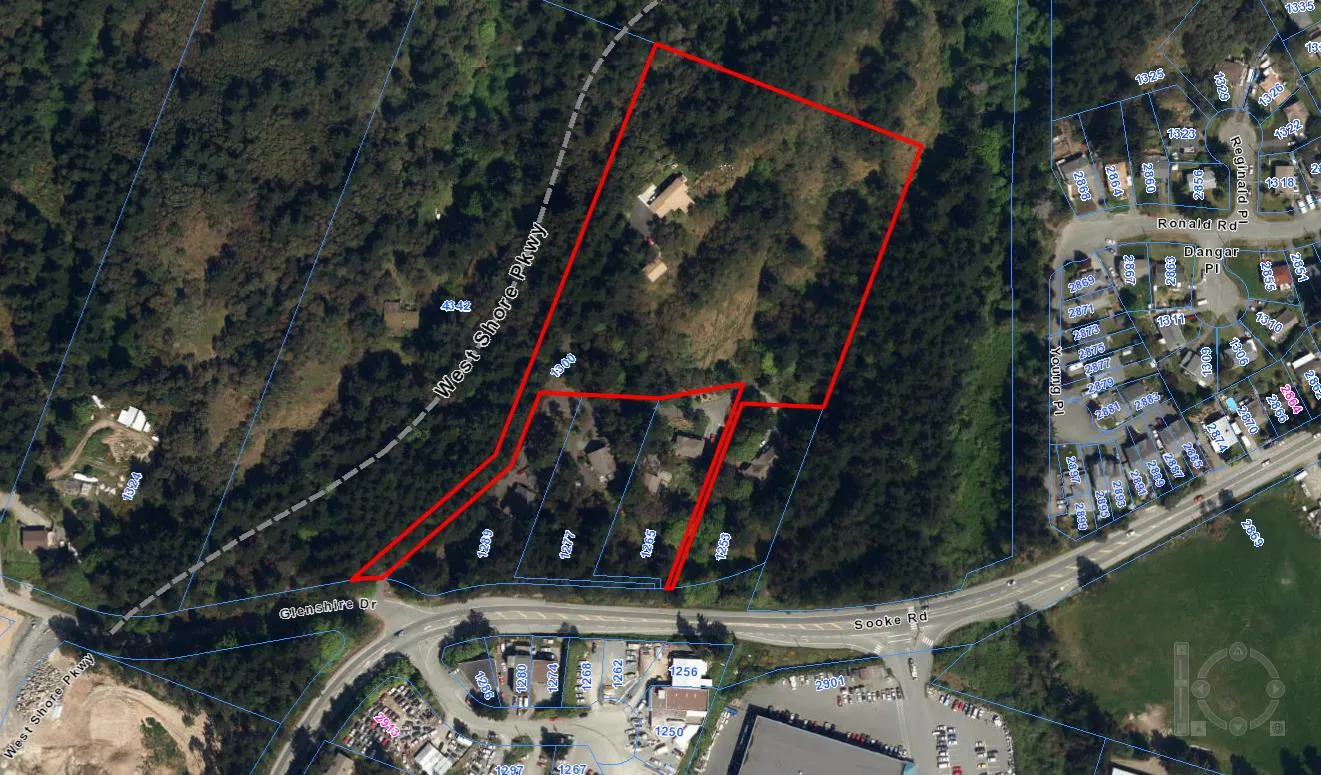
The subject site is located in South Langford, north of Sooke Road and between Glenshire Drive and the Slegg Lumber site. The site is surrounded by large, rural residential properties to the south and west, undeveloped land to the north, and one- and two-family dwellings to the east. A variety of business park and industrial uses are located south of the site, across Sooke Road.
The subject site currently contains a one-family dwelling and detached garage accessed via a long driveway from Glenshire Drive. The majority of the site is forested, and the slope rises approximately 55 m (181 ft) from the southeast corner to the northwest corner. The site is located within the Extreme Interface Fire Hazard, Steep Slopes and Habitat and Biodiversity Development Permit Areas. As a result, Environmental and Hazard Land Development Permits will be required prior to development of the site.
Table 2: Surrounding Land Uses
| Direction | Zoning | Use |
|---|---|---|
| North | Comprehensive Development 3 – Westhills (CD3) | Undeveloped |
| East | Comprehensive Development 3 – Westhills (CD3) One- and Two-Family Residential (R2) |
Undeveloped Residential dwellings |
| South | Rural Residential 5 (RR5) General Industrial (M2) Business Park 2 – Sooke Road (BP2) |
Residential dwellings Residential dwellings, industrial uses Slegg Lumber |
| West | Rural Residential 4 (RR4) Park and Open Space (P4) |
Residential dwellings Mount Wells Regional Park |
COUNCIL POLICY
OFFICIAL COMMUNITY PLAN
The subject site is designated as Hillside or Shoreline by the City of Langford Official Community Plan (OCP). This designation is applied to existing, low intensity settled areas throughout the community with a high percentage of open space, and to undeveloped areas located on a hillside or near the shoreline, and it is intended to:
- Be a predominantly residential district that supports a range of clustered low, medium and high density housing choices including secondary suites. Higher building forms, such as point towers, will be permitted on hillsides to maximize open space provided that some conditions are satisfied;
- Permit schools, community facilities, and other institutional uses throughout the area;
- Encourage home-based businesses and permit home-based accommodations such as bed and breakfasts;
- Integrate parks, open spaces and green corridors such as creeks, wildlife corridors and trails throughout the area. Large playfields are discouraged due to grading requirements, but site and topographic responsive pocket parks, enhanced viewpoints, graded hiking and walking trails, children’s play areas, and outdoor exercise areas are strongly encouraged on hillside areas;
- Allow for Neighbourhood Centres to emerge in the form of high and medium density clustered mixed-use nodes; and
- Local transit stops where appropriate.
The Hillside or Shoreline designation also provides a number of objectives and policies for development, including:
- Objective 3.11 Retain significant open space and maintain ecosystem values
Policy 3.11.1 When considering development on greenfield sites, retain a minimum of 40% of the site area as public and/or private open space… if a Neighbourhood Area Plan or Neighbourhood Centre Plan (NCP) is in place, each subdivision application will benefit from the overall conditions of the NAP as it relates to open space retention on an area-wide basis. That is, if 40% of the area has been retained for open space throughout the area-wide plan, individual parcels created through subdivision within designated development areas in the NAP will not be expected to achieve the 40% open space on a site by site basis.
Policy 3.11.2 Ensure connectivity of open spaces so as to create a network that supports water flow (i.e. creeks), trails, and/or wildlife movement.
- Objective 3.13 Cluster development on hillside sites to facilitate the protection of all or a significant portion of open space and/or environmentally sensitive areas.
Policy 3.13.1 Lower density development sites such as single detached homes and townhouses shall integrate public and private open space and/or preserved historical or environmentally sensitive features extensively in and around development sites.
The proposed development at 1300 Glenshire Drive is intended to be clustered in the western portion of the site, leaving approximately 30% of the site as open space. The proposed open space area includes some of the steepest slopes on the site, as well as environmentally sensitive areas adjacent to a designated riparian area that extends north and south on the abutting Westhills property. This open space area is considered to satisfy the Official Community Plan intentions for open space preservation.
DEVELOPMENT PERMIT AREAS
As previously noted, the subject site is located in the Extreme Interface Fire Hazard, Steep Slopes, and Habitat and Biodiversity Development Permit areas. Should the proposed rezoning be approved, Environmentally Sensitive and Hazardous Area Development Permits accompanied by reports from qualified professionals will be required prior to development.
COMMENTS
DEVELOPMENT PROPOSAL
The applicant has requested that the property at 1300 Glenshire Drive be rezoned from Rural Residential 4 (RR4) to Attached Housing (RM2A) to permit the development of a cluster of approximately 80 – 100 townhouses on a private roadway from a future extension of the West Shore Parkway. The development is anticipated to have a density of approximately 35 dwelling units per hectare (14 dwelling units per acre).
The applicant has not submitted detailed site, building, elevation or landscaping plans. Therefore, compliance with the requirements of the Subdivision and Development Servicing Bylaw No. 1000 will be determined through the subsequent land development process and compliance with the Zoning Bylaw and Multi-Family Design Guidelines will be confirmed through a Form and Character Development Permit should the requested rezoning application be approved.
The applicant has indicated that they intend to construct the proposed townhouses only 6.0 m (20 ft) from the front and rear property lines, requiring variances to reduce the minimum setbacks from 7.5 m (25 ft) from the front property line and 10 m (33 ft) from the rear property line as required in the RM2A Zone. These variances will facilitate increased separation between the development and retained open space. Council has authorized the Director of Planning, through the Multi-Family Design Guidelines, to approve setback variances that “reduce the impact of development on surrounding lands, or avoid sensitive ecosystems”.
A detailed site plan will be required for any Development Permit applications. Council may wish to require that a detailed site plan illustrating the proposed townhouse development and retention of at least 30% of the site as open space be provided prior to Public Hearing.
Table 3: Proposal Data
| Item | Permitted by RR4 Zone (Current Zoning) | Permitted by RM2A Zone (Proposed Zoning) | Proposed by Rezoning Application |
|---|---|---|---|
| Permitted Uses | Accessory buildings and uses Agriculture Boarding kennel Breeding kennel Group daycare Home occupation Intensive agriculture on lots >4 ha (10 ac) One-family dwelling Two-family dwelling Secondary suite in a one-family dwelling Temporary construction and real estate marketing offices Not more than 4 boarders in a one-family dwelling Uses permitted by Section 3.01 |
Accessory buildings and uses Attached housing Home occupation Temporary construction and real estate marketing offices Townhouses Uses permitted by Section 3.01 |
Townhouses |
| Minimum Subdivision Lot Requirements | 40 ha (100 ac) without sewer 0.4 ha (1 ac) with sewer |
1,800 m2 (0.44 ac) 18 m (59 ft) lot width |
N/A |
| Maximum Density | N/A | 0.5 FAR 0.6 FAR, with density bonus payments 0.75 FAR with 50% of parking underground |
35 units/ha (14 units/ac) |
| Maximum Height | 10.5 m (34 ft) | 9.0 m (30 ft) | Not known |
| Maximum Lot Coverage | 30% or 1,000 m2 (10,760 ft2) | 35% | Not known |
| Minimum Front Yard Setback | 7.5 m (25 ft) | 7.5 m (25 ft) | 6.0 m (20 ft) *Variance required |
| Minimum Interior Side Yard Setback | 3.0 m (10 ft) | 6.0 m (20 ft) | Not known |
| Minimum Exterior Side Yard Setback | 3.0 m (10 ft), or 5.5 m (18 ft) for garage or carport facing exterior side lot line | 7.5 m (25 ft) | Not known |
| Minimum Rear Yard Setback | 10 m (33 ft) | 10 m (33 ft) | 6.0 m (20 ft) *Variance required |
| Minimum Parking Requirement | 2 spaces per dwelling unit | 2 spaces per dwelling unit plus visitor parking spaces | Not known |
PEDESTRIAN, CYCLING AND MOTORIST NETWORK
The proposed development will be accessed via a future extension of the West Shore Parkway, and the location of the intersection has already been determined by the Engineering Department. Once completed, West Shore Parkway will provide good vehicular connectivity south to Sooke Road, and north to the Langford Parkway and other areas of the City. The Ministry of Transportation has no objection to the proposed rezoning with access via the West Shore Parkway, but would require further review of the application if plans are revised to provide access onto Sooke Road.
The applicant has also agreed to provide secondary emergency access via a trail connection south to the new driveway for the properties at 1289, 1277, 1265 and 1253 Valemount Court (currently named Glenshire Drive). Council may choose to require the applicant to provide a detailed site plan illustrating this emergency access prior to Public Hearing and require the access to be secured by statutory right-of-way prior to the issuance of a Building Permit. This can be required as a condition of rezoning and secured through a Section 219 Covenant registered on Title prior to Bylaw adoption.
Full frontage improvements, as well as road dedication and the construction of a left turn lane on West Shore Parkway will be required for the proposed development. Boulevard landscaping will be required as per the Parks Department. Council may choose to require the necessary frontage improvements and off-site construction as a condition of rezoning, to be secured through a Section 219 Covenant, and to require the necessary road dedication, to the satisfaction of the Director of Engineering, prior to Bylaw adoption.
INFRASTRUCTURE
Sanitary sewer and water services are not currently available to the subject site, and will be required prior to site preparation and construction of the proposed townhouses. As a condition of subdivision, the City’s Subdivision and Development Servicing Bylaw No. 1000 requires that the applicant demonstrate, to the satisfaction of the Director of Engineering and the Approving Officer, that stormwater will be appropriately managed. Council may wish to require both on-site and off-site stormwater management plans, to the satisfaction of the Director of Engineering and the Approving Officer, prior to Public Hearing.
The Fire Department has indicated that an established water supply meeting the Fire Underwriter’s Survey (FUS) requirements will need to be established before construction. As well, a wildfire assessment report will be required as part of a subsequent Development Permit as the subject site is located within the High Interface Fire Hazard Area.
NUISANCE EASEMENTS
Although the South Vancouver Island Rangers gun range is located approximately 1,400 m (4,593 ft) from the subject site (as the crow flies), it has been the City’s practice to require the applicant to register a Section 219 Covenant on the title of the proposed development to notify future property owners that the gun range may be audible and may generate noise nuisances. Council may choose to require that this Covenant be registered as a condition of rezoning.
NEIGHBOURHOOD CONSULTATION
The applicant has been asked undertake neighbourhood consultation through door-to-door canvassing to notify and consult with surrounding property owners of the proposed development prior to Public Hearing.
FINANCIAL CONTRIBUTIONS
Rezoning the subject property to permit higher densities of development may increase the assessed value of the property, and this may increase municipal revenue. As the applicant will connect the development to municipal sewers, and as the applicant will complete frontage improvements, the direct capital costs to the municipality associated with this development will be negligible. A summary of the amenity contributions required pursuant to Council’s Amenity Contribution Policy POL-011-PLAN and Development Cost Changes required pursuant to DCC Bylaw No. 26 are listed in Tables 4 and 5 below, based on the applicant’s indicated density of 35 dwelling units per hectare (14 dwelling units per acre), or 96 dwelling units.
Table 4 – Amenity Contributions per Council Policy
| Amenity Item | Per SFE contribution – West Langford | Total (58.56 SFE) |
|---|---|---|
| General Amenity Reserve Fund | $6,000 per Single Family Equivalent (SFE) | $351,360 |
| Affordable Housing Reserve Fund | $1,000 per SFE | $58,560 |
| TOTAL POLICY CONTRIBUTIONS | $7,000 per SFE | $409,920 |
Table 5 – Development Cost Charges
| Development Cost Charge | Per unit contribution | Total (96 units) |
|---|---|---|
| Roads | $3,985 per townhouse unit | $382,560 |
| Park Improvement | $1,890 per dwelling unit | $181,440 |
| Park Acquisition | $1,100 per dwelling unit | $105,600 |
| Incremental Storage Improvement Fees | $331.65 per dwelling unit | $31,838.40 |
| Integrated Survey Area | $35 per parcel created | $35 |
| Subtotal (DCCs paid to City of Langford) | $701,473.40 | |
| CRD Water | $2,655.34 per dwelling unit | $254,912.64 |
| School Site Acquisition | $698 per dwelling unit | $67,008 |
| TOTAL (estimated) DCCs | $1,023,394.04 |
OPTIONS
Option 1
That the Planning, Zoning and Affordable Housing Committee recommend that Council:
- Direct staff to prepare a bylaw to amend the zoning designation of the property located at 1300 Glenshire Drive from Rural Residential 4 (RR4) to Attached Housing (RM2A), subject to the following terms and conditions:
a) That the owner agrees to provide, as a bonus for increased density, the following contributions prior to Building Permit issuance:
i. $6,000 per Single Family Equivalent (SFE) towards the General Amenity Reserve Fund; and
ii. $1,000 per SFE towards the Affordable Housing Reserve Fund;
b) That the applicant provides, prior to Public Hearing, the following:
i. A detailed site plan illustrating the proposed development, retention of at least 30% of the site as open space, and an emergency access via a trail connection south to the new driveway for the properties at 1289, 1277, 1265 and 1253 Valemount Court; and
ii. A stormwater management plan to the satisfaction of the Director of Engineering;
c) That the applicant provides, prior to Bylaw Adoption, a Section 219 covenant, registered in priority of all other charges on title, that agrees to the following:
i. That a minimum of 30% of the site be retained as open space in its natural state;
ii. That all frontage improvements, to the satisfaction of the Director of Engineering, be constructed prior to subdivision approval or Building Permit issuance, whichever occurs first;
iii. That the required left hand turn lane on West Shore Parkway be constructed, to the satisfaction of the Director of Engineering, prior to subdivision approval or Building Permit issuance, whichever occurs first;
iv. That any on- or off-site improvements required by the stormwater management plan be implemented prior to subdivision approval or Building Permit issuance, whichever occurs first, to the satisfaction of the Director of Engineering;
v. That a water supply, meeting the Fire Underwriter’s Survey (FUS) requirements be established prior to any construction on-site;
vi. That advisory notes be written and registered on Title to provide future owners with the understanding that the South Vancouver Island Rangers gun range is located approximately 1,400 m (4,593 ft) from the subject site and may generate a noise nuisance; and
vii. That the emergency access to the driveway located south of the subject site be secured by a statutory right-of-way prior to the issuance of a Building Permit;
d) That the applicant registers, prior to Bylaw Adoption, a road dedication plan to the satisfaction of the Director of Engineering.
OR Option 2
- Reject this application for rezoning.
Submitted by
- Sarah Herring, MCIP, RPP, Planner
Concurrence
- Matthew Baldwin, MCIP, RPP Director of Planning
- Lorne Fletcher, Manager of Community Safety and Municipal Enforcement
- Mike Leskiw, Parks and Recreation Manager
- Michelle Mahovlich, P.Eng, P.Geo, Director of Engineering
- Leah Stohmann, MCIP, RPP, Deputy Director of Planning
- Steve Ternent, Director of Finance
- Braden Hutchins, Director of Corporate Services
- Darren Kiedyk, Deputy Chief Administrative Officer
- Jim Bowden, Chief Administrative Officer
:sh
Document Images
(1)