DocumentsStaff ReportOct 2, 2017Pages 18–26
Staff Report to Planning, Zoning and Affordable Housing Committee - Z17-0022 & OCP17-0003 (976 Dunford Avenue)
Planner's report from August 21, 2017 recommending preparation of bylaws to amend the OCP and rezone 976 Dunford Ave from RM2 to MU2 to permit a proposed 5-storey, 24-unit apartment building; includes site analysis, zoning comparison, parking, amenity contributions and DCC estimates.
Key facts
- Applicant: Rohan Rupf on behalf of Chad Bryden / Verity Construction Ltd.
- Civic Address: 976 Dunford Avenue
- Legal Description: LOT A, SECTION 79, ESQUIMALT DISTRICT, PLAN 26317
- Lot Size: 742.43 m2
- Proposal: 5-storey apartment building with 24 two-bedroom units (proposed FAR 3.23; height 5 storeys)
Staff Report to Planning, Zoning and Affordable Housing Committee
Date: August 21, 2017
Department: Planning
Application No.: Z17-0022 and OCP17-0003
Subject: Application to amend the current OCP designation from “Neighbourhood” to “City Centre” and to rezone 976 Dunford Avenue from Rezone RM2 (Attached Housing) Zone to MU2 (Mixed Use Residential Commercial 2) Zone to permit the construction of a 5 story apartment building.
PURPOSE
Rohan Rupf has applied on behalf of Chad Bryden with Verity Construction Ltd. to amend the Official Community Plan designation of 976 Dunford Avenue from “Neighbourhood” to “City Centre” and to rezone this property from the RM2 (Attached Housing) Zone to MU2 (Mixed Use Residential Commercial 2) Zone in order to permit the construction of a 5 storey apartment building.
BACKGROUND
PREVIOUS APPLICATIONS
The parcel at 976 Dunford Avenue was created in 1973 from the subdivision of what is currently 974 Dunford Avenue.
No development or building permits have been applied for in recent history.
Table 1: Site Data
| Item | Details |
|---|---|
| Applicant | Rohan Rupf |
| Owner | Verity Construction Ltd. |
| Civic Address | 976 Dunford Avenue |
| Legal Description | LOT A, SECTION 79, ESQUIMALT DISTRICT, PLAN 26317 |
| Size of Property | 742.43 m2 |
| DP Areas | None |
ZONING AND OCP SUMMARY
Zoning
- Existing: RM2 (Attached Housing)
- Proposed: MU2 (Mixed Use Residential Commercial 2)
OCP Designation
- Existing: Neighbourhood
- Proposed: City Centre
SITE AND SURROUNDING AREA
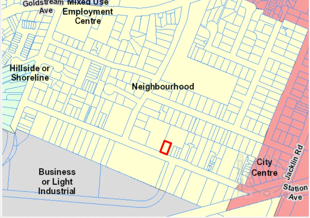
Dunford Avenue is located between the downtown core to the north and light industrial uses to the south. The north side of Dunford Avenue is comprised of residential developments of varying densities while the south side of Dunford Avenue is solely made up of industrial uses.
The subject property contains a single storey home, setback a fair distance from the street frontage, with a driveway that accesses Dunford Avenue directly. The existing home is one of the few single family dwellings on a street that has experienced a great deal of medium to high density redevelopment.
The properties on the west side of the subject parcel are zoned for attached housing and contain four blocks of townhouse units. On the east of the property a driveway leads to a pan handle lot that contains a multi-residential building while the property across this driveway contains three townhouse units, each with driveways accessed directly on Dunford Avenue.
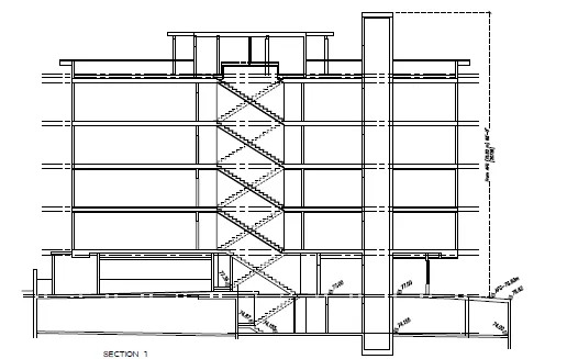
Table 2: Surrounding Land Uses
| Zoning | Use |
|---|---|
| North (974 Dunford Avenue, pan handle lot) — RM3 (Attached Housing 3) | Apartments |
| East (984 Dunford Avenue) — RM2 (Attached Housing 2) | Townhouses |
| South (979 Dunford Avenue) — M1 (Light Industrial) | Accessory Parking for adjacent industrial use |
| West (970 Dunford Avenue, across panhandle lot’s driveway) — RM2 (Attached Housing 2) | Townhouses |
COUNCIL POLICY
OFFICIAL COMMUNITY PLAN
The subject property is currently designated as “Neighbourhood” within Langford’s Official Community Plan. The Neighbourhood designation supports a range of low to medium density residential housing as well as the small scale commercial and institutional uses that support them. The Neighbourhood policy designation supports a density of approximately 40 units per hectare or 16 units per acre. The subject parcel at 976 Dunford Avenue is approximately 742.43 m2 or 0.18 acres, in accordance with the density modifiers within the OCP designation, this parcel would only support 3 units, much less than what the applicant is proposing.
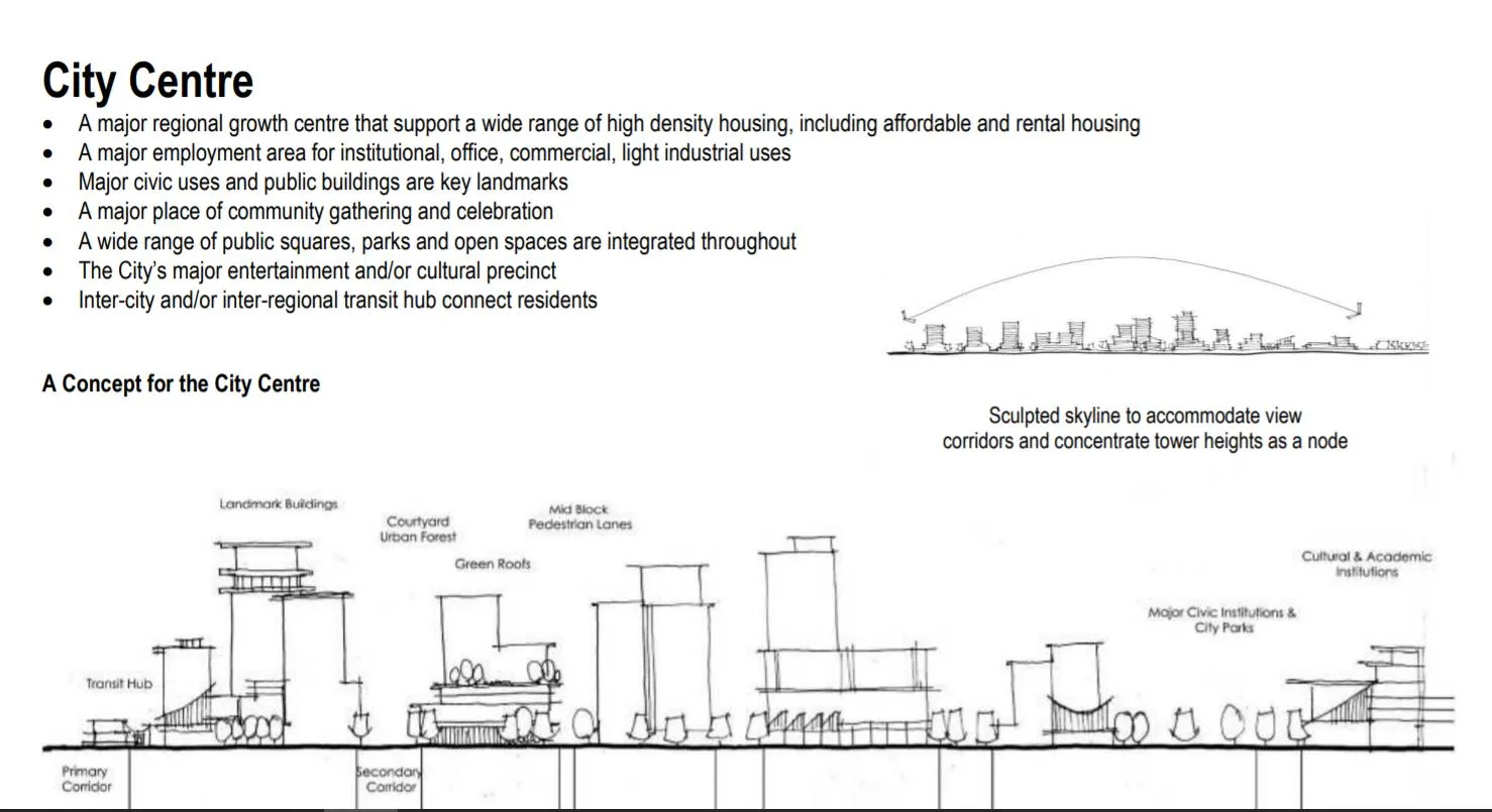
Amending the Official Community Plan designation to “City Centre” would remove this limit on density and may be warranted given the location of the subject property in relation to existing resources and amenities and to the downtown core.
The City Centre designates parcels within the downtown core, and just beyond, as prime areas for major employment, community gathering, and high density housing developments. High density redevelopment, close to downtown Langford, has resulted in the need for the boundaries of the City Centre designation to be re-established as the need for housing that is close to existing services and employment sectors increases.
DEVELOPMENT PERMIT AREAS
The subject property is not within any environmentally sensitive or hazardous Development Permit Areas, therefore only a development permit to address the form and character of the proposed development is required.
COMMENTS
ZONING AND DEVELOPMENT PROPOSAL
The MU2 (Mixed Use Residential and Commercial 2) zone allows for high density developments, with a height limit of 10 storeys and generous setback allowances that promote densification within the downtown area.
The proposed building will be approximately 5 stories, including two floors of parking, one of which will be contained underground. All 24 units are proposed to be 2 bedroom units, with balconies that will face Dunford Avenue to the south and the rear of the property to the north.
The applicant’s proposal will fit within the MU2 guidelines, requiring setback variances, while still staying within the prescribed floor area ratio and height limits. If Council is supportive of the proposal they may wish to authorize the Director of Planning to issue any variances through a subsequent development permit.
A landscape plan has not been submitted, however the applicant has indicated that the intention is to include roof top garden space in an effort to alleviate the loss of landscaping that may occur if interior side setbacks variances are issued a subsequent development permit application.
Table 3: Proposal Data
| Item | Permitted by RM2 (Attached Housing 2) (Current Zoning) | Permitted by MU2 (Mixed Use Residential Commercial 2) (Proposed Zoning) | Proposed by Zoning and OCP Amendment |
|---|---|---|---|
| Permitted Use | attached housing townhouses |
apartments various commercial various institutional |
apartments |
| Density | 35 units per hectare | 16 units per hectare | No density modifier |
| Floor Area Ratio | 0.6 | 4.5 | 3.23 |
| Height | 9 m | 10 storeys | 5 storeys |
| Site Coverage | 35% | 90% | 83% |
| Front Yard Setback | 7.5 m | 1.2 m | 3.89 m |
| Interior Side Yard Setback | 6 m | 1.2 m or 6 m when adjoining a Neighbourhood designated parcel | 0.07 m* |
| Exterior Side Yard Setback | 7.5 m | 1.2 m | N/A |
| Rear Yard Setback | 10 m | 7.5 m when adjoining a Neighbourhood designated parcel | 2.87 m* |
| Parking Requirement | under Neighbourhood policy designation: 2 spaces per unit, 5 visitor spaces for buildings with 21 units or more = 53 units |
2 spaces per unit, 5 visitor spaces for buildings with 21 units or more = 53 units | 1 space per unit, 5 visitor spaces for buildings with 21 units or more = 29 spaces 28 spaces, with 1 required space provided off site* |
*Variances
PEDESTRIAN, CYCLING AND MOTORIST NETWORK
Currently the subject parcel is within the Neighbourhood policy area, where parking ratios follow the Zoning Bylaw No. 300 requirement of 2 parking spaces for units with 2 or more bedrooms and an additional 5 spaces for visitors. If Council is supportive of the OCP designation amendment the proposed development would require 1 space per unit and additional 5 spaces for visitor parking, with no regard for the numbers of bedrooms. Developments within the City Centre OCP designation allow for this reduced parking ratio as amenities and services central to downtown are more likely to be within walking distance.
The applicant is intending to provide 29 parking spaces to support the 24 unit apartment building, with 15 spaces contained underground, 13 spaces at grade level and 1 space within the boulevard frontage. In accordance with the Zoning Bylaw, parking must be located within the boundary of the subject property, as such this proposal may have to be amended to provide the required parking on the site, unless Council approves a variance to the Zoning regulations to permit this.
In alignment with the City Centre objectives the subject property is within close proximity to public transit stops. The #50 bus route stops along Jacklin Road, approximately half a kilometre away, and provides service to and from downtown Victoria. In front of the subject property stops for routes #56, #58, and #53 provide transit service to several locations within Langford and to the Colwood Bus Exchange where a bus transfers are available.
Alternate modes of transportation are within close proximity to the subject property. Sidewalks are located along the north side of Dunford Avenue, providing pedestrian access along Jacklin Road to Goldstream Avenue in the downtown core. New bicycle lanes have been constructed along Dunford Avenue, which connects to the E and N commuter trail that runs parallel along Station Avenue.
Frontage improvements, to the standards of the Subdivision and Servicing Bylaw, No. 1000 will be required prior to building permit issuance. Frontage improvements shall include artificial turf for any separated boulevard under 3 m in width, and trees shall be planted every 15 m that will be serviced via drip irrigation provided by the subject property.
A construction parking management plan, to ensure traffic flow is not affected by construction on the property, will be required prior to building permit issuance.
INFRASTRUCTURE
The property is connected to sanitary sewer and city water services, however upgrades to infrastructure or services in order to accommodate the proposed development may be required, and will be at the applicant’s expense.
A stormwater management plan will also be required conditional to rezoning the property and recommendations within the plan implemented prior to building permit issuance.
NEIGHBOURHOOD CONSULTATION
The applicant has been asked to provide confirmation that public engagement has occurred, in regards to the subject application to rezone, prior to the Public Hearing meeting.
FINANCIAL CONTRIBUTIONS
Rezoning the subject property, to permit higher densities of development, may increase the assessed value of the property, and this may increase municipal revenue. As the applicant will connect the development to municipal sewers, and as the applicant will complete frontage improvements, the direct capital costs to the municipality associated with this development will be negligible. A summary of the amenity contributions required pursuant to Council’s Amenity Contribution Policy and Development Cost Changes required pursuant to DCC Bylaw No. 26 are listed in Tables 4 and 5 below.
In accordance to Council’s Affordable Housing and Amenity Contribution fees policy the applicant may be eligible for a reduction to amenity contributions if they enter into an agreement with the City, registered with the subject property that secures rental tenure of the residential units for 10 years. While this reduction, as per policy, only applies to lands within the downtown pedestrian commercial area, Council has approved site specific reductions outside of this area such as 691 and 697 Hoylake Road, 3031 Jacklin Road and 732 Meadford Road. Council may wish to provide direction as to whether they wish to allow for the reduction of amenity contributions for this project.
Table 4 – Amenity Contributions per Council Policy
| Amenity Item | Per unit contribution | Total @24 units |
|---|---|---|
| General Amenity Reserve Fund | $2562 | $61,488 |
| Affordable Housing Reserve Fund | $610 | $14,640 |
| TOTAL POLICY CONTRIBUTIONS | $3172 | $76,128 |
Table 5 – Development Cost Charges
| Development Cost Charge | Per unit contribution | Total @24 units |
|---|---|---|
| Roads | $3,188 | $76,512 |
| Park Improvement | $1,890 | $45,360 |
| Park Acquisition | $1,100 | $26,400 |
| Incremental Storage Improvement Fees | $331.65 | $7,959.60 |
| Integrated Survey Area | $0 (no new lots created) | $0 |
| Subtotal (DCCs paid to City of Langford) | $6,509.65 | $156,231.60 |
| CRD Water | $2,323.43 | $5,5762.32 |
| School Site Acquisition | $558 | $13,392 |
| TOTAL (estimate) DCCs | $9,391.08 | $225,385.92 |
OPTIONS
Option 1
That the Planning, Zoning and Affordable Housing Committee recommend that Council:
- Direct staff to prepare a bylaw to amend the zoning designation of the property located at 976 Dunford Avenue from the RM2 (Attached Housing) zone to the MU2 (Mixed Use Residential Commercial 2) zone and direct staff to prepare a bylaw to amend the OCP designation of the property located at 976 Dunford from Neighbourhood to City Centre designation, subject to the following terms and conditions:
a) That the owner agrees to provide, as a bonus for increased density, the following contributions per new dwelling unit , prior to building permit issuance
i. $2,562 towards the General Amenity Reserve Fund;
ii. $610 towards the Affordable Housing Reserve Fund;
b) That the applicant provides, prior to Public Hearing, the following:
i. Confirmation that public engagement has occurred regarding the subject application to rezone the property at 976 Dunford Avenue.
c) That the applicant provides, prior to Bylaw Adoption, a Section 219 covenant, registered in priority of all other charges on title, that agrees to the following:
i. That prior to building permit issuance the applicant provides full frontage improvements, to the standards of the Subdivision and Development Servicing Bylaw No. 1000, and to the satisfaction of the Director of Engineering;
ii. That any necessary above or underground infrastructure or servicing upgrades, extensions or other required servicing requirements are to be fulfilled at the applicant’s expense;
iii. That prior building permit issuance the applicant provides a stormwater management plan to standards of Bylaw No. 1000 and to the satisfaction of the Director of Engineering.
iv. That the applicant agrees to implement the recommendations within the stormwater management plan as well as assumes responsibility for all costs, on site and off site, required to manage the subject property’s drainage concerns;
v. That prior to building permit issuance the applicant agrees to provide a Construction Parking Management plan, subject to approval from the Director of Engineering;
vi. That the applicant acknowledges and agrees that the proximity to industrial business operators may be a nuisance to the future residents of the development and that the applicant agrees to divulge this information, as is feasible, to prospective residents.
OR
Option 2
Proceed with the items in Option 1; and
Allow the applicant to pursue a 75% reduction to the amenity contribution funds if they secure rental tenure of the property for the next 10 years through an agreement registered on the title of the subject property.
OR
Option 3
- Reject this application to rezone 976 Dunford Road.
Submitted by:
Lauren Morhart, MCIP, RPP Planner 2
Concurrence:
Matthew Baldwin, MCIP, RPP Director of Planning
Mike Leskiw, Parks and Recreation Manager
Michelle Mahovlich, P.Eng, P.Geo, Director of Engineering
Leah Stohmann, MCIP, RPP, Deputy Director of Planning
Michael Dillabaugh, CPA, CA, Director of Finance
Darren Kiedyk, Chief Administrative Officer
:lhm