DocumentsBylawJan 18, 2016Pages 138–140
BYLAW NO. 1610 - Langford Zoning Bylaw, Amendment No. 445 (2792 Leigh Rd), 2015 (SECOND AND THIRD READING)
Bylaw No.1610 to amend the zoning of 2792 Leigh Rd into the BT1 zone with site-specific provisions allowing a single-family dwelling with a suite (including in an accessory building); presented for second and third reading in Bylaws section.
Key facts
- Bylaw No.: 1610 (Amendment No.445)
- Subject: 2792 Leigh Rd (LOT 7, SECTION 99, PLAN 22423; PID 000-183-521)
- Agenda: Bylaws section (second and third reading)
VISTA DAWN ROAD CLOSURE BYLAW NO. 1609, 2016
Road Closure Bylaw
WHEREAS, pursuant to Section 40 of the Community Charter, Council may, by bylaw, close a portion of a highway to traffic and remove the dedication of the highway, if prior to adopting the bylaw, Council publishes notices of its intention in a newspaper and provides an opportunity for persons who consider they are affected by the bylaw to make representations to Council;
AND WHEREAS the Council of the City of Langford deems it expedient to close to traffic and remove the dedication of highway of those portions of highway comprising a total of approximately 0.175 hectares (0.43 acres) known as Vista Dawn Place, which was dedicated as highway by Plan 27882, shown outlined in bold black on the reference plan prepared by Minda C. Riley, BCLS on the 10th day of December, 2015, a reduced copy of which is attached hereto (the "Road Closure Plan");
AND WHEREAS notices of Council's intention to close that portion of highway to traffic and to remove its dedication as highway were published in a newspaper and posted in the public notice posting place, and Council has provided an opportunity for persons who consider they are affected by the closure to make representations to Council;
AND WHEREAS the Council does not consider that the closure of the Closed Road will affect the transmission or distribution facilities or works of utility operators;
NOW THEREFORE the Council of the City of Langford, in open meeting assembled, enacts as follows:
Attached to this Bylaw as Schedule "A" and forming part of this Bylaw is a reduced copy of the reference plan of highway closure (the "Road Closure Plan").
The City hereby authorizes the closure to traffic and removal of highway dedication of: the 0.175 hectares (0.43 acres) of highway (which was 'dedicated as highway at the Victoria Land Title Office by Plan 27882), labelled "Closed Road" on the Road Closure Plan (the "Closed Road").
On deposit of the Road Closure Plan and all other documentation for the closure of the Closed Road in the Victoria Land Title Office, the Closed Road is closed to public traffic, it shall cease to be public highway, and its dedication as a highway is cancelled.
The Mayor and the Administrator of the City are authorized to execute all deeds of land, plans and other documentation necessary to affect this road closure and disposition.
This Bylaw may be cited as "Vista Dawn Road Closure Bylaw No.1609".
Readings and Adoption
Vista Dawn Road Closure Bylaw No. 1609
Page 2 of 3
READ A FIRST TIME this day of , 2016.
READ A SECOND TIME this day of ,2016.
READ A THIRD TIME this day of ,2016
APPROVED BY THE MINISTRY OF TRANSPORTATION AND INFRASTRUCTURE this day of 2016.
ADOPTED this day of , 2016.
MAYOR
(Certified Correct)
CORPORATE OFFICER
SCHEDULE "A" — Road Closure Plan
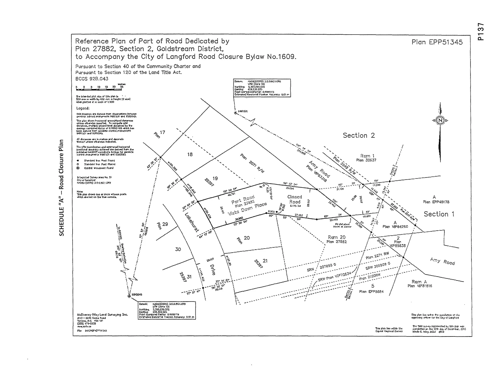
Reference Plan text and associated plan details as included in the document:
SCHEDULE "A" — Road Closure  Plan

Plan EPP5a5i
Rem A
Plan vIP8I516

Reference Plan of Port of Road Dedicated by
Plan 27882, Section 2, Goldstream District,
to Accompany the City of Langford Road Closure Bylaw No.1609.

Pursuant to Section 40 of the Community Charter and
Pursuant to Section 120 ot the Land Title Act.

BOOS 920.043

Legend:

Plan 27552
Plan EPP51345

Section 2

Reference plan prepared by Minda C. Riley, BCLS on the 10th day of December, 2015.

[Map graphic with dimensions and property identifiers showing the area labelled "Closed Road" comprising approximately 0.175 hectares (0.43 acres) dedicated as highway by Plan 27882.]
(Note: The document contains a reduced copy of the reference plan with survey annotations, bearings, and plan numbers as shown above.)
Document Images
(2)